Coriolis Effect - Bermuda Institute of Ocean Sciences
Coriolis Effect - Bermuda Institute of Ocean Sciences
Coriolis Effect - Bermuda Institute of Ocean Sciences

Create successful ePaper yourself
Turn your PDF publications into a flip-book with our unique Google optimized e-Paper software.
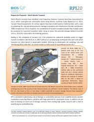
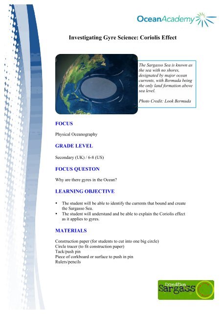
Investigating Gyre Science: <strong>Coriolis</strong> <strong>Effect</strong>The Sargasso Sea is known asthe sea with no shores,designated by major oceancurrents, with <strong>Bermuda</strong> beingthe only land formation abovesea level.Photo Credit: Look <strong>Bermuda</strong>FOCUSPhysical <strong>Ocean</strong>ographyGRADE LEVELSecondary (UK) / 6-8 (US)FOCUS QUESTONWhy are there gyres in the <strong>Ocean</strong>?LEARNING OBJECTIVE• The student will be able to identify the currents that bound and createthe Sargasso Sea.• The student will understand and be able to explain the <strong>Coriolis</strong> effectas it applies to gyres.MATERIALSConstruction paper (for students to cut into one big circle)Circle tracer (to fit construction paper)Tack/push pinPiece <strong>of</strong> corkboard or surface to push in pinRulers/pencils
AUDIO VISUAL MATERIALSOverhead ProjectorTEACHING TIMEOne 45-minute periodSEATING ARRANGEMENTStudents should sit in pairs for this activityKEY WORDS/ VOCABULARYGyre- Major rotational surface current systems in the ocean (5 majorgyres)<strong>Coriolis</strong> <strong>Effect</strong>- The “force” (not a true force) on moving particlesresulting from the earth’s rotation eastward. It causes moving bodies todeflected to the right in the Northern Hemisphere and to the left in theSouthern Hemisphere. This deflection is more apparent at the poles andnot seen at the equator.Current- the motion <strong>of</strong> water as it flows down a slope, pushed by windstress or tidal forces.Equator- an imaginary line <strong>of</strong> latitude (0 degrees) on the earth surfacethat divides the earth into the Northern and Southern Hemispheres. Theline is located equidistant from both North and South polesPrime Meridian- an imaginary line <strong>of</strong> longitude (0 degrees) that dividesthe sphere <strong>of</strong> the earth into an Eastern and Western Hemisphere.Physical <strong>Ocean</strong>ography- the study <strong>of</strong> the physical conditions andphysical processes within the ocean, including the way the ocean movesand the properties <strong>of</strong> the ocean waters in <strong>of</strong> themselves.Latitude- Angular distance north to south <strong>of</strong> the equator measured at 0degrees to 90 degrees at the polesLongitude- Angular distance measured from the prime meridian (0degrees) at Greenwich, England, east or west through 180 degrees
Figure 3: Earth’s major wind patterns. If you look closely you can pointout to students how the ocean tracks these winds. Photo courtesy <strong>of</strong>classroomatsea.net.Because <strong>of</strong> the <strong>Coriolis</strong> effect you will notice that gyres move clockwisein the Northern Hemisphere and counter-clockwise in the SouthernHemisphere. This makes for a rotational movement <strong>of</strong> water known as agyre. <strong>Bermuda</strong> specifically is located within the North AtlanticSubtropical Gyre. Within this gyre is the Sargasso Sea, named for thefloating brown algae, Sargassum. This area is knows as the “sea with noshores” as the Gulf stream lies to the west, North Atlantic Drift to theNorth, Canary Current to the east, and North Atlantic Equatorial Currentto the south. These borders are always changing depending on the AzoresHigh Pressure centerseasonally.Figure 4: Major ocean surfacecurrents that define the SargassoSea
• Hold the ruler diagonal to the X as shown in this photo.Figure 6: How to place the ruler to draw Western boundary• Have one student rotate the earth in a counterclockwise direction whilethe other students draw a line about 5 inches long while holding the ruler.A curved line will result and will turn towards the right, just as thecurrents <strong>of</strong> the Sargasso Sea turn in to the right due to the <strong>Coriolis</strong> effect.• Continue your arrows until all 4 <strong>of</strong> the major surface currents that borderthe Sargasso Sea are drawn and labeled. This demonstrates the <strong>Coriolis</strong>effect in the Northern Hemisphere (particles will bend to the right)• Flip over your ocean and repeat the exercise turning counterclockwise.The line will curve to the left. This is what happens in the southernhemisphere. You can have the students look up major ocean currents thatmake up a gyre in the Southern Hemisphere hereo http://www.srh.noaa.gov/jetstream/ocean/currents_max.htm• Review for understanding:o Which currents bound the Sargasso Sea?o Why do the currents <strong>of</strong> the Sargasso Sea turn to the right?o What effects does that have on the sea itself? On <strong>Bermuda</strong>?EXTENSIONS:Merry-go-roundAnother way to demonstrate the <strong>Coriolis</strong> effect is using the idea <strong>of</strong> amerry-go-round. The playground might have one for students to practicedemonstrating the effect with foam balls, such as in the video link below.http://www.youtube.com/watch?v=mcPs_OdQOYUDrift CardsAnother extension may be exploring how scientists are exploring oceancurrents and how they move by talking about Drift Card studies. Therehave been some really interesting cases <strong>of</strong> drift cards washing up on
eaches 33 years later! Learn about how NOAA and other organizationsuse drift cards to understand how oil and other pollutants will travelhttp://the.honoluluadvertiser.com/article/2002/Dec/23/ln/ln32ajan.htmlhttp://www.oar.noaa.gov/spotlite/archive/spot_driftcard.htmlhttp://www.mnn.com/earth-matters/wilderness-resources/stories/whatcan-28000-rubber-duckies-lost-at-sea-teach-us-about-http://www.cbc.ca/news/story/2003/07/22/rubber_ducks030722.htmlUsing Radar to track Currentshttp://marine.rutgers.edu/mrs/codar.htmlTracking and measuring plasticsTalking also about the accumulation <strong>of</strong> plastics within these gyres? Whydoes this happen, where does the marine debris go.NASA:http://oceanmotion.org/html/gatheringdata/flotsam.htmAlgalita:http://www.algalita.org5 Gyreshttp://5gyres.org/The Plastic <strong>Ocean</strong>s Projecthttp://theplasticocean.blogspot.com/Importance <strong>of</strong> currents to different pr<strong>of</strong>essions:http://education.nationalgeographic.com/education/activity/benefitsstudying-ocean-currents/?ar_a=1FUTHER READING:http://www.education.noaa.gov/<strong>Ocean</strong>_and_Coasts/<strong>Ocean</strong>_Currents.htmlhttp://www.education.noaa.gov/Special_Topics/Hands_On_Activities/<strong>Ocean</strong>_Motion.pdfhttp://www.srh.noaa.gov/jetstream/ocean/currents_max.htmhttp://oceanservice.noaa.gov/facts/sargassosea.htmlhttp://www.youtube.com/watch?v=7DVL0ugj1O4&feature=endscreenhttp://tos.org/oceanography/articles/24-1_ebbesmeyer.pdf
OCEAN LITERACY PRINCIPLES:Principle 1: The Earth has one big ocean with many features.1c: Throughout the ocean there is one interconnected circulation systempowered by wind, tides, the force <strong>of</strong> the earths’ rotation (<strong>Coriolis</strong> effect),the Sun, and water density differences. The shape <strong>of</strong> the ocean basins andadjacent land masses influence the path <strong>of</strong> circulation.Principle 3: The ocean is a major influence on weather and climate.3f: The ocean has had, and will continue to have, a significant influenceon climate change by absorbing, storing and moving heat, carbon andwater.Principle 7: The ocean is largely unexplored7d: New Technologies, sensors and tools are expanding our ability toexplore the ocean. <strong>Ocean</strong> scientists are relying more and more onsatellites, drifters, buoys, subsea observatories and unmannedsubmersibles.CLIMATE LITERACY PRINCIPLES:Principle 1: The sun is the primary source <strong>of</strong> Energy for our Earth’sclimate system.1D: gradual change in Earth’s rotation and orbit around the sun changethe intensity <strong>of</strong> sunlight received in our planet’s polar and equatorialregions. For at least the last 1 million years, these changes occurred in100,000-year cycles that produced ice ages and shorter warm periodsbetween them.Principle 2: Climate is regulated by complex interactions amongcomponents <strong>of</strong> the earth system.2D: Covering 70% <strong>of</strong> Earth’s surface, the ocean exerts a major control onclimate by dominating Earth’s energy and water cycles. It has thecapacity to absorb large amounts <strong>of</strong> solar energy. Heat and water vaporare redistributed globally through density-driven ocean currents andatmospheric circulation. Changes in ocean circulation caused by tectonicmovements or large influxes <strong>of</strong> fresh water from melting polar ice canlead to significant and even abrupt changes in climate, both locally and onglobal scales.Principle 5: Our understanding <strong>of</strong> the climate system is improvedthrough observations, theoretical studies, and modeling.5B: Environmental observations are the foundation for understanding theclimate system. From the bottom <strong>of</strong> the ocean to the surface <strong>of</strong> the Sun,instruments on weather stations, buoys, satellites, and other platformscollect climate data. To learn about past climates, scientists use naturalrecords, such as tree rings, ice cores, and sedimentary layers. Historicalobservations, such as native knowledge and personal journals, alsodocument past climate change.