Floodplain Management in Illinois - Illinois Department of Natural ...
Floodplain Management in Illinois - Illinois Department of Natural ...
Floodplain Management in Illinois - Illinois Department of Natural ...

You also want an ePaper? Increase the reach of your titles
YUMPU automatically turns print PDFs into web optimized ePapers that Google loves.
Understand<strong>in</strong>g the Floodway<br />
A<br />
Flood<br />
Fr<strong>in</strong>ge<br />
Simulated<br />
Encroachment<br />
*Surcharge not to exceed 0.1 foot [Ill<strong>in</strong>ois requirement]<br />
C<br />
Area <strong>of</strong> floodpla<strong>in</strong> that could be<br />
used for development by rais<strong>in</strong>g ground<br />
L<strong>in</strong>e<br />
L<strong>in</strong>e<br />
A<br />
C<br />
<strong>Floodpla<strong>in</strong></strong><br />
B<br />
D<br />
Floodway<br />
Stream<br />
Channel<br />
Surcharge*<br />
D<br />
Flood<br />
Fr<strong>in</strong>ge<br />
Simulated<br />
Encroachment<br />
= Flood Elevation Before Encroachment<br />
= Flood Elevation After Encroachment<br />
B<br />
Flood elevation before<br />
encroachment<br />
Simulated Encroachment<br />
Terms and<br />
Def<strong>in</strong>itions<br />
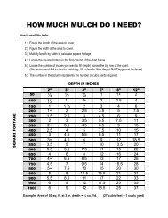
The Floodway is the channel <strong>of</strong> a river<br />
or other watercourse and the adjacent<br />
land areas that must be reserved <strong>in</strong><br />
order to pass the base flood without<br />
<strong>in</strong>creas<strong>in</strong>g the water surface elevation<br />
more than a designated height.<br />
Computer models <strong>of</strong> the floodpla<strong>in</strong><br />
are used to simulate “encroachment”<br />
or fill <strong>in</strong> the flood fr<strong>in</strong>ge <strong>in</strong> order to<br />
predict where and how much the<br />
base flood elevation would <strong>in</strong>crease if<br />
the floodpla<strong>in</strong> is allowed to be filled.<br />
In Ill<strong>in</strong>ois, the Floodway boundary is<br />
drawn where the computer model<br />
<strong>in</strong>dicates that the water surface will<br />
<strong>in</strong>crease 0.1' due to the simulated<br />
encroachment.<br />
For Floodway proposals, before a local floodpla<strong>in</strong> permit can be issued a State <strong>of</strong> Ill<strong>in</strong>ois Permit<br />
must be obta<strong>in</strong>ed. You may need a qualified eng<strong>in</strong>eer to make sure your<br />
proposed project won’t <strong>in</strong>crease flood<strong>in</strong>g on others.<br />
5<br />
ILLINOIS QUICK GUIDE