Bahrain : Complete Profile - What is GIS - World Health Organization
Bahrain : Complete Profile - What is GIS - World Health Organization
Bahrain : Complete Profile - What is GIS - World Health Organization

Create successful ePaper yourself
Turn your PDF publications into a flip-book with our unique Google optimized e-Paper software.
<strong>Health</strong> Systems <strong>Profile</strong>-<strong>Bahrain</strong><br />
Regional <strong>Health</strong> Systems Observatory- EMRO<br />
To facilitate sustainable development in the long term and with the depletion of oil<br />
production, the government took early steps to diversify the economy. Today, the<br />
economic base of <strong>Bahrain</strong> includes oil and petrochemicals, manufacturing such as<br />
aluminum, dry dock for supertankers, banking, financial, and commercial and services.<br />
With its highly developed communication and transport facilities, <strong>Bahrain</strong> <strong>is</strong> home to<br />
numerous multinational firms with business in the Gulf, its central location have also<br />
made it a favorable transit spot for many airlines to numerous Western and Eastern<br />
destinations.<br />
According to the Min<strong>is</strong>try of Finance, the prov<strong>is</strong>ional data of national account in 2003<br />
indicates economic growth of 6.8% compared with 5.2% in 2002. Where as DDP at<br />
constant price increased to BD 3058.5 Million from 2864.3 Million in 2002. Growth <strong>is</strong><br />
ascribed to the improvement in most of the non-oil economic activities. On the other<br />
hand, GDP at constant price increased by 13.7% in 2003 as a result of r<strong>is</strong>e in the world<br />
oil price and improvement in the performance of the finance sectors in <strong>Bahrain</strong>. <strong>Bahrain</strong><br />
has a Free Trade Agreement (FTA) with the United States. Th<strong>is</strong> was signed in<br />
September 2004.<br />
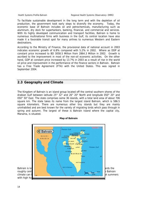
2.3 Geography and Climate<br />
The Kingdom of <strong>Bahrain</strong> <strong>is</strong> an <strong>is</strong>land group located off the central southern shores of the<br />
Arabian Gulf between latitude 25° 32" and 26° 20" North and longitude 050° 20" and<br />
050° 50" East. The state compr<strong>is</strong>es some 36 <strong>is</strong>lands, with a total land area of about 706<br />
square km. The state takes its name from the largest <strong>is</strong>land <strong>Bahrain</strong>, which <strong>is</strong> 586.5<br />
square kilometers. There are numerous other tiny <strong>is</strong>lands but they are mainly<br />
uninhabited and are best known for the variety of migrating birds which pass through in<br />
spring and autumn. The largest of these <strong>is</strong> <strong>Bahrain</strong> Island where the capital city,<br />
Manama, <strong>is</strong> situated.<br />
Map of <strong>Bahrain</strong><br />
<strong>Bahrain</strong> <strong>is</strong> low lying. Typically the limestone bedrock slopes very gently towards the<br />
roughly central peak of Jebel Dukhan (only 137 metres above sea level). The <strong>Bahrain</strong><br />
climate can be generally described as cool winters with sparse rainfall and hot summers<br />
with high humidity.<br />
14