Utility Fact Sheet - Office of Physical Plant - Penn State University
Utility Fact Sheet - Office of Physical Plant - Penn State University
Utility Fact Sheet - Office of Physical Plant - Penn State University

Create successful ePaper yourself
Turn your PDF publications into a flip-book with our unique Google optimized e-Paper software.
<strong>Penn</strong> <strong>State</strong> <strong>University</strong><br />
<strong>Utility</strong> <strong>Fact</strong> <strong>Sheet</strong><br />
Water Storage<br />
<strong>University</strong> Park’s potable water system has four elevated storage tanks. Water Tower #1 is located near the Nittany Lion<br />
Inn. It was erected in 1937 and has a storage capacity <strong>of</strong> 500,000 gallons. Water Tower #2 is located near the North<br />
Halls. It was erected in 1956 and has a storage capacity <strong>of</strong> 750,000 gallons. Water Tower #3 is located north <strong>of</strong> the<br />
<strong>Physical</strong> <strong>Plant</strong> Building. It was erected in 1962 and has a storage capacity <strong>of</strong> 1,000,000 gallons. Water Tower #4 is<br />
located on the Golf Course. It was erected in 1992 and has a storage capacity <strong>of</strong> 1,500,000 gallons.<br />
Sanitary System<br />
A campus sanitary system is owned and operated by the <strong>University</strong>. The wastewater treatment plant is located on<br />
<strong>University</strong> Drive near Route 26. The plant currently operates at over 2 million gallons/average day. Included in the<br />
current daily throughput is about 500,000 gpd taken from the Borough <strong>of</strong> <strong>State</strong> College for a fee. None <strong>of</strong> the effluent is<br />
wasted to nearby Spring Creek; instead it is pumped to spray irrigation fields after being treated. Some parts on the north<br />
side <strong>of</strong> campus utilize a local sanitary system owned by the <strong>University</strong> Area Joint Authority on a fee for service basis.<br />
Storm System<br />
The <strong>University</strong> Park Storm Drain System is currently a 100% gravity flow system consisting <strong>of</strong> approximately 66 linear<br />
miles <strong>of</strong> storm drain pipes varying from 4 inches to 66 inches in diameter, and thousands <strong>of</strong> inlets and manholes. The<br />
<strong>University</strong> has varying levels <strong>of</strong> documentation for the entire system including approximately 1/2 <strong>of</strong> which is precisely<br />
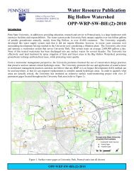
surveyed. The <strong>University</strong> owns large tracts <strong>of</strong> land in the Centre Region tributary to the Big Hollow (Chpt. 93, CWF),<br />
Shavers Creek (Chpt. 93, HQ-CWF), Thompson Run (Chpt. 93, HQ-CWF), Spruce Creek (Chpt. 93, HQ-CWF), Slab<br />
Cabin Run (Chpt. 93, CWF sections), and the main stem <strong>of</strong> Spring Creek (Chpt. 93, HQ-CWF).<br />
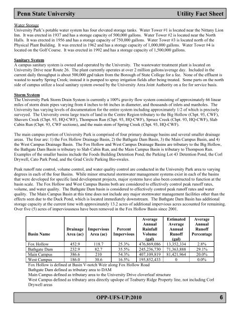
The main campus portion <strong>of</strong> <strong>University</strong> Park is comprised <strong>of</strong> four primary drainage basins and several smaller drainage<br />
areas. The four are: 1) the Fox Hollow Drainage Basin, 2) the Bathgate Dam Basin, 3) the Main Campus Basin, and 4)<br />
the West Campus Drainage Basin. The Fox Hollow and West Campus Drainage Basins are tributary to the Big Hollow,<br />
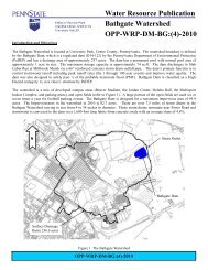
the Bathgate Dam Basin is tributary to Slab Cabin Run, and the Main Campus Basin is tributary to Thompson Run.<br />
Examples <strong>of</strong> the smaller basins include the Foods Building Detention Pond, the Parking Lot 43 Detention Pond, the Corl<br />
Drywell, Cato Park Pond, and the Grad Circle Parking Bio-swales.<br />
Peak run<strong>of</strong>f rate control, volume control, and water quality control are conducted in the <strong>University</strong> Park area to varying<br />
degrees in each <strong>of</strong> the four Basins. While minor structural stormwater management systems exist in each <strong>of</strong> the basins<br />
that were developed for specific land development projects, major systems have also been constructed to function at the<br />
basin scale. The Fox Hollow and West Campus Basins both are considered to effectively control peak run<strong>of</strong>f rates,<br />
volume, and water quality. The Bathgate Dam basin is considered to effectively control peak run<strong>of</strong>f rates and water<br />
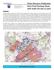
quality. The Main Campus Basin at this time does not include any major stormwater management facilities other than the<br />
effects seen due to the Duck Pond, which is located immediately downstream. The Bathgate Dam Basin has additional<br />
storage capacity at the current time with approximately 13.2 acres <strong>of</strong> additional impervious acres accounted for remaining.<br />
Over five (5) acres <strong>of</strong> imperviousness have been removed in the Fox Hollow Basin since 2001.<br />
Basin Name<br />
Drainage<br />
Area (ac)<br />
Impervious<br />
Area (ac)<br />
Percent<br />
Impervious<br />
Average<br />
Annual<br />
Rainfall<br />
Volume<br />
(gal)<br />
Estimated<br />
Average<br />
Annual<br />
Run<strong>of</strong>f<br />
(gal)<br />
Average<br />
Annual<br />
Run<strong>of</strong>f<br />
Percentage<br />
Fox Hollow 452.9 118.7 25.3% 476,869,086 13,352,334 2.8%<br />
Bathgate Dam 232.9 82.7 35.5% 245,236,730 71,363,888 29.1%<br />
Main Campus 386.6 210 54.3% 407,109,819 81,421,964 20.0%<br />
West Campus 186.0 30.6 16.5% 195,852,433 0 0.0%<br />
Fox Hollow is defined at Basin V-notch Weir along Fox Hollow Road<br />
Bathgate Dam defined as tributary area to DAM<br />
Main Campus defined as tributary area to the <strong>University</strong> Drive cloverleaf structure<br />
West Campus defined as tributary area directly upslope <strong>of</strong> Teaburry Ridge Property line, not including Corl<br />
Drywell areas<br />
OPP-UFS-UP:2010 6