Rapid survey of the birds of the Atewa Range Forest Reserve, Ghana
Rapid survey of the birds of the Atewa Range Forest Reserve, Ghana
Rapid survey of the birds of the Atewa Range Forest Reserve, Ghana
- No tags were found...

Create successful ePaper yourself
Turn your PDF publications into a flip-book with our unique Google optimized e-Paper software.
Chapter 13<br />
Besides, probably because <strong>of</strong> <strong>the</strong>ir fascinating similarity<br />
to human beings, monkeys and apes are amongst <strong>the</strong> most<br />
important tourist attractions <strong>of</strong> <strong>the</strong> African intertropical<br />
zone (Weber 1993). The Republic <strong>of</strong> <strong>Ghana</strong>, with its sixteen<br />
inventoried primate species (Gartlan 1982) and ecotourism<br />
projects such as <strong>the</strong> Kakum National Park (Central region)<br />
and <strong>the</strong> Boabeng-Fiema monkey sanctuary (Brong-Ahafo region),<br />
is no exception. In this context, primate conservation<br />
and <strong>the</strong> preservation <strong>of</strong> primates’ natural habitat are ecologically<br />
essential, but also become an economic challenge for<br />
local authorities and communities. In terms <strong>of</strong> politics as<br />
well, <strong>the</strong> charismatic images <strong>of</strong> simians can be used to influence<br />
conservation decisions and environmental policies in<br />
general.<br />
Despite all this, since <strong>the</strong> early 1980’s over 50% <strong>of</strong><br />
primate diversity faces some form <strong>of</strong> threat (Chapman and<br />
Peres 2001). Primates and <strong>the</strong>ir natural habitat are increasingly<br />
threatened globally by hunting and o<strong>the</strong>r human<br />
activities including logging, slash-and-burn agriculture and<br />
mining (Mittermeier et al. 2005). Such activities, leading to<br />
destruction and fragmentation <strong>of</strong> <strong>the</strong> forest, not only affect<br />
primate species’ abundance and ranging patterns, but also<br />
<strong>the</strong>ir group size and composition (Dominy and Duncan<br />
2005). Given this tenuous conservation context, any area<br />
hosting threatened primate populations deserves attention<br />
and in particular those areas representing rare ecosystems or<br />
remnant habitats benefiting from protected status.<br />
The Republic <strong>of</strong> <strong>Ghana</strong>, located in <strong>the</strong> Guinean <strong>Forest</strong>s<br />
<strong>of</strong> West Africa, is one <strong>of</strong> <strong>the</strong> 34 global Hotspots for biodiversity<br />
conservation, and probably <strong>the</strong> most important<br />
one in terms <strong>of</strong> primate diversity (Bakarr et al. 2004). The<br />
<strong>Atewa</strong> <strong>Range</strong> <strong>Forest</strong> <strong>Reserve</strong> (<strong>Atewa</strong>), located in <strong>the</strong> Eastern<br />
Region <strong>of</strong> <strong>Ghana</strong> (see Map), is part <strong>of</strong> <strong>the</strong> eastern sub-region<br />
<strong>of</strong> this biodiversity hotspot, which is known to contain<br />
severely fragmented forests <strong>of</strong> high conservation value.<br />
<strong>Atewa</strong> consists <strong>of</strong> a 23,660 ha range <strong>of</strong> hills oriented approximately<br />
north-south, and is characterized by steep-sided<br />
slopes topped by flat plateaux. The reserve lies within <strong>the</strong><br />
moist semi-deciduous forest zone, and three-quarters <strong>of</strong> it is<br />
composed <strong>of</strong> healthy Upland Evergreen <strong>Forest</strong>. <strong>Atewa</strong> is one<br />
<strong>of</strong> only two reserves in <strong>Ghana</strong> representing this forest type,<br />
and those two reserves toge<strong>the</strong>r hold 95% <strong>of</strong> <strong>the</strong> Upland<br />
Evergreen <strong>Forest</strong> <strong>of</strong> <strong>Ghana</strong> (BirdLife International 2005).<br />
The very ancient soils <strong>of</strong> <strong>the</strong> <strong>Atewa</strong> <strong>Range</strong>, which are reputed<br />
to be bauxite laden, contain <strong>the</strong> headwaters <strong>of</strong> several <strong>of</strong><br />
<strong>Ghana</strong>’s major watercourses including <strong>the</strong> Birim, Densu and<br />
Ayensu rivers. This area has been legally protected for over<br />
eighty years, and was more recently declared a Globally Significant<br />
Biodiversity Area (GSBA). Despite <strong>the</strong>se measures,<br />
<strong>Atewa</strong> is still threatened by illegal logging and hunting, and<br />
has recently been granted by <strong>the</strong> <strong>Ghana</strong>ian government on<br />
concession to ALCOA for bauxite mineral exploration.<br />
Methods<br />
A <strong>survey</strong> <strong>of</strong> primate diversity, abundance and distribution<br />
was conducted in <strong>Atewa</strong> from 7-22 June 2006. The RAP<br />
<strong>survey</strong> focused on three study sites with campsites located<br />
on <strong>the</strong> top <strong>of</strong> <strong>the</strong> large plateaus dominating <strong>the</strong> reserve at an<br />
altitude <strong>of</strong> 800 m. Atiwiredu (Site 1) still contains relatively<br />
healthy forest although it is <strong>the</strong> zone most impacted by mineral<br />
prospecting activities and a number <strong>of</strong> roads and large<br />
trenches have increased access to <strong>the</strong> top <strong>of</strong> <strong>the</strong> Atiwiredu<br />
plateau. Asiakwa South (Site 2), located at an intermediate<br />
latitude between Sites 1 and 3, shows evidence <strong>of</strong> disturbance,<br />
with moderate scars resulting from drilling activities<br />
and o<strong>the</strong>r human disturbance (mainly hunting and clearing<br />
<strong>of</strong> forest for wood). Asiakwa North (Site 3) presents <strong>the</strong><br />
healthiest forest <strong>of</strong> <strong>the</strong> three sites, but it is also <strong>the</strong> site where<br />
<strong>the</strong> highest hunting pressure was recorded.<br />
Five to six days were spent in each <strong>of</strong> <strong>the</strong> three sampling<br />
sites to get an overall picture <strong>of</strong> <strong>Atewa</strong>’s primate diversity<br />
(see Map for site locations). Sixteen days were spent <strong>survey</strong>ing<br />
<strong>the</strong> forest, using a combination <strong>of</strong> field methods<br />
complemented by interviews with local villagers. Primates<br />
and evidence <strong>of</strong> <strong>the</strong>ir presence were recorded both from line<br />
transects and “reconnaissance <strong>survey</strong>s” during thirteen days<br />
(a total <strong>of</strong> 93 hours). One full day was devoted to interviews<br />
with local hunters and cultivators in villages surrounding <strong>the</strong><br />
reserve.<br />
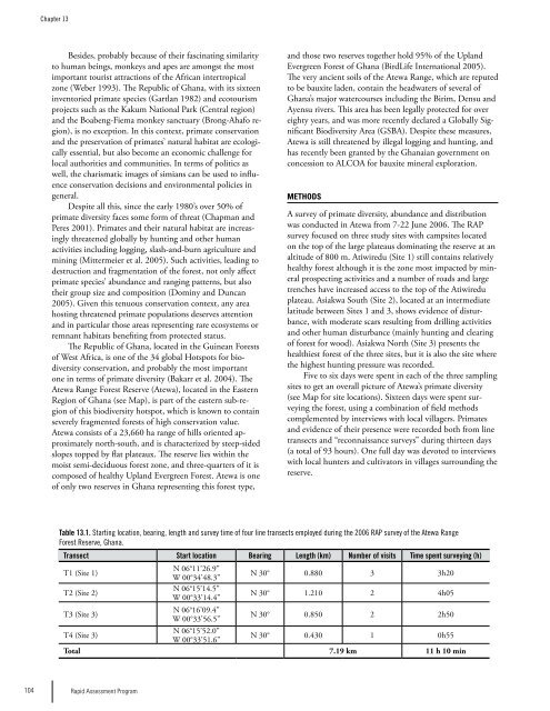
Table 13.1. Starting location, bearing, length and <strong>survey</strong> time <strong>of</strong> four line transects employed during <strong>the</strong> 2006 RAP <strong>survey</strong> <strong>of</strong> <strong>the</strong> <strong>Atewa</strong> <strong>Range</strong><br />
<strong>Forest</strong> <strong>Reserve</strong>, <strong>Ghana</strong>.<br />
Transect Start location Bearing Length (km) Number <strong>of</strong> visits Time spent <strong>survey</strong>ing (h)<br />
T1 (Site 1)<br />
N 06°11’26.9”<br />
W 00°34’48.3”<br />
N 30° 0.880 3 3h20<br />
T2 (Site 2)<br />
N 06°15’14.5”<br />
W 00°33’14.4”<br />
N 30° 1.210 2 4h05<br />
T3 (Site 3)<br />
N 06°16’09.4”<br />
W 00°33’56.5”<br />
N 30° 0.850 2 2h50<br />
T4 (Site 3)<br />
N 06°15’52.0”<br />
W 00°33’51.6”<br />
N 30° 0.430 1 0h55<br />
Total 7.19 km 11 h 10 min<br />
104 <strong>Rapid</strong> Assessment Program