Rapid survey of the birds of the Atewa Range Forest Reserve, Ghana
Rapid survey of the birds of the Atewa Range Forest Reserve, Ghana
Rapid survey of the birds of the Atewa Range Forest Reserve, Ghana
- No tags were found...

You also want an ePaper? Increase the reach of your titles
YUMPU automatically turns print PDFs into web optimized ePapers that Google loves.
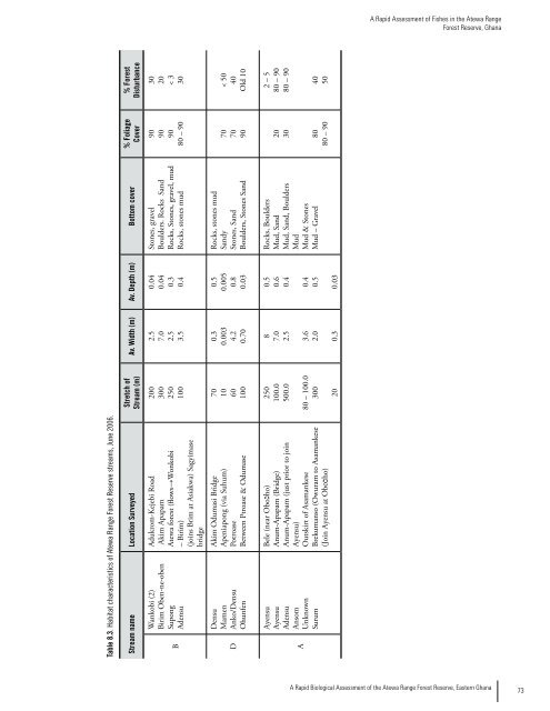
A <strong>Rapid</strong> Assessment <strong>of</strong> Fishes in <strong>the</strong> <strong>Atewa</strong> <strong>Range</strong><br />
<strong>Forest</strong> <strong>Reserve</strong>, <strong>Ghana</strong><br />
Table 8.3. Habitat characteristics <strong>of</strong> <strong>Atewa</strong> <strong>Range</strong> <strong>Forest</strong> <strong>Reserve</strong> streams, June 2006.<br />
Stream name Location Surveyed<br />
B<br />
D<br />
Wankobi (2)<br />
Birim Oben-ne-oben<br />
Supong<br />
Adensu<br />
Densu<br />
Mamen<br />
Anko/Densu<br />
Ohunfen<br />
Adukrom-Kejebi Road<br />
Akim Apapam<br />
<strong>Atewa</strong> forest (flows→Wonkobi<br />
– Birim)<br />
(joins Brim at Asiakwa) Sagyimase<br />
bridge<br />
Akim Odumasi Bridge<br />
Apeniapong (via Suhum)<br />
Potroase<br />
Between Ptroase & Odumase<br />
A<br />
Ayensu<br />
Ayensu<br />
Adensu<br />
Ansom<br />
Unknown<br />
Surum<br />
Bele (near Oboכho)<br />
Anum-Apapam (Bridge)<br />
Anum-Apapam (just prior to join<br />
Ayensu)<br />
Outskirt <strong>of</strong> Asamankese<br />
Brekumanso (Owuram to Asamankese<br />
(Join Ayensu at Oboכho)<br />
Stretch <strong>of</strong><br />
Stream (m)<br />
200<br />
300<br />
250<br />
100<br />
70<br />
10<br />
60<br />
100<br />
250<br />
100.0<br />
500.0<br />
80 – 100.0<br />
300<br />
20<br />
Av. Width (m) Av. Depth (m) Bottom cover<br />
2.5<br />
7.0<br />
2.5<br />
3.5<br />
0.04<br />
0.04<br />
0.3<br />
0.4<br />
Stones, gravel<br />
Boulders. Rocks Sand<br />
Rocks, Stones, gravel, mud<br />
Rocks, stones mud<br />
0.3<br />
0.003<br />
4.2<br />
0.70<br />
0.5<br />
0.005<br />
0.8<br />
0.03<br />
Rocks, stones mud<br />
Sandy<br />
Stones, Sand<br />
Boulders, Stones Sand<br />
8<br />
7.0<br />
2.5<br />
3.6<br />
2.0<br />
0.5<br />
0.6<br />
0.4<br />
0.4<br />
0.5<br />
Rocks, Boulders<br />
Mud, Sand<br />
Mud, Sand, Boulders<br />
Mud<br />
Mud & Stones<br />
Mud – Gravel<br />
0.3<br />
0.03<br />
% Foliage<br />
Cover<br />
90<br />
90<br />
90<br />
80 – 90<br />
70<br />
70<br />
90<br />
20<br />
30<br />
80<br />
80 – 90<br />
% <strong>Forest</strong><br />
Disturbance<br />
30<br />
20<br />
< 3<br />
30<br />
< 50<br />
40<br />
Old 10<br />
2 – 5<br />
80 – 90<br />
80 – 90<br />
40<br />
50<br />
A <strong>Rapid</strong> Biological Assessment <strong>of</strong> <strong>the</strong> <strong>Atewa</strong> <strong>Range</strong> <strong>Forest</strong> <strong>Reserve</strong>, Eastern <strong>Ghana</strong><br />
73