Storm Data and Unusual Weather Phenomena - CIG
Storm Data and Unusual Weather Phenomena - CIG
Storm Data and Unusual Weather Phenomena - CIG
Create successful ePaper yourself
Turn your PDF publications into a flip-book with our unique Google optimized e-Paper software.
ALABAMA, Southwest<br />
Mobile County<br />
Gr<strong>and</strong> Bay<br />
03<br />
Choctaw County<br />
Pushmataha<br />
Covington County<br />
Red Level<br />
Baldwin County<br />
Central Portion<br />
Mobile County<br />
South Portion<br />
Mobile County<br />
South Portion<br />
Baldwin County<br />
Central Portion<br />
ALASKA, Northern<br />
AKZ223<br />
AKZ223-226<br />
AKZ219<br />
<strong>Storm</strong> <strong>Data</strong> <strong>and</strong> <strong>Unusual</strong> <strong>Weather</strong> <strong>Phenomena</strong><br />
Time<br />
Local/<br />
Path<br />
Length<br />
Path<br />
Width<br />
Number of<br />
Persons<br />
Estimated<br />
Damage<br />
Location Date St<strong>and</strong>ard (Miles) (Yards) Killed Injured Property Crops Character of <strong>Storm</strong><br />
07<br />
11<br />
1420CST<br />
1422CST<br />
1525CST<br />
1527CST<br />
1530CST<br />
1532CST<br />
0<br />
0<br />
0<br />
0<br />
0<br />
0<br />
Hail (0.88)<br />
Hail (0.88)<br />
Hail (0.75)<br />
18 0550CST<br />
0 0 500K<br />
Flash Flood<br />
1600CST<br />
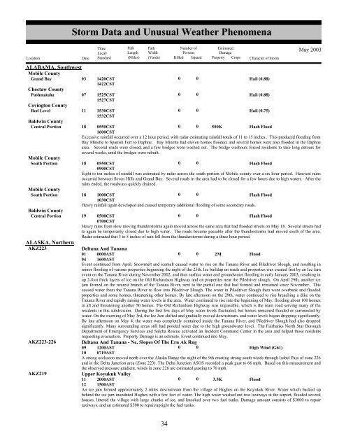
Excessive rainfall occurred over a 12 hour period, with radar estimating rainfall totals of 11 to 15 inches.. This produced flooding from<br />
Bay Minette to Spanish Fort to Daphne. Bay Minette had eleven homes flooded, <strong>and</strong> several homes were also flooded in the Daphne<br />
area. Several roads were closed, <strong>and</strong> a few bridges were washed out. The bridge washouts forced residents to take long detours for<br />
several weeks, until the bridges were rebuilt.<br />
18 0550CST<br />
0 0<br />
Flash Flood<br />
0900CST<br />
Eight to ten inches of rainfall was estimated by radar across the south portion of Mobile county over a six hour period. Heaviest rains<br />
occurred between Seven Hills <strong>and</strong> Gr<strong>and</strong> Bay. Several roads in the area had to be closed for a few hours due to high waters. After the<br />
rains ended, the roadways quickly drained.<br />
18 1000CST<br />
0 0<br />
Flash Flood<br />
1030CST<br />
Heavy rainfall again developed <strong>and</strong> caused temporary additional flooding of some secondary roads.<br />
May 2003<br />
19 0500CST<br />
0 0<br />
Flash Flood<br />
0700CST<br />
Heavy rains from slow moving thunderstorms again moved across the same area that had flooded streets on May 18. Several streets had<br />
to again be temporarily closed due to high water. The roads became passable after the thunderstorms had moved south of the area.<br />
Radar estimated that 3 to 5 inches of rain fell from the thunderstorms during a three hour period.<br />
Deltana And Tanana<br />
01 0000AST<br />
0 0 2M<br />
Flood<br />
04 1600AST<br />
Event continued from April. Snowmelt <strong>and</strong> icemelt caused water to rise on the Tanana River <strong>and</strong> Piledriver Slough, <strong>and</strong> resulting in<br />
minor flooding of various properties beginning the night of the 25th. Ice buildup on roads <strong>and</strong> properties was created first by an Ice Jam<br />
event on the Tanana River during November 2002, <strong>and</strong> then surface water <strong>and</strong> groundwater flooding in early January 2003, resulting in<br />
up 2-foot thick layers of ice on the Old Richardson Highway <strong>and</strong> on properties near the Piledriver slough. On April 29th, another ice<br />
jam formed on the nearest branch of the Tanana River, next to the partial one that had formed <strong>and</strong> remained since November. This<br />
caused water from the Tanana River to flow into Piledriver Slough. The water in Piledriver Slough then went overbank <strong>and</strong> flooded<br />
properties <strong>and</strong> some homes, threatening other homes. By late afternoon on the 29th, water continued to rise breaching a dike on the<br />
Tanana River <strong>and</strong> rapidly raising water levels in the area. Water continued to rise into the beginning of May, flooding about 100 homes<br />
in all <strong>and</strong> threatening another 50 homes. The Old Richardson Highway was impassible, which is the main road serving many of the<br />
residents in this subdivision. During the first few days of May water levels fluctuated, but homes remained flooded or surrounded by<br />
water. On the morning of May 3rd, the Ice Jam shifted <strong>and</strong> gradually moved downstream, <strong>and</strong> water levels began dropping significantly.<br />
By late afternoon on May 4, the water was completely contained inside the Tanana River, <strong>and</strong> Piledriver Slough had also dropped<br />
significantly. Many surrounding areas still had ponded water due to the high groundwater level. The Fairbanks North Star Borough<br />
Department of Emergency Services <strong>and</strong> Salcha Rescue activated an Incident Comm<strong>and</strong> Center in the area <strong>and</strong> helped those residents<br />
requesting evacuation. Property Damage is an estimate. Event continued into May.<br />
Deltana And Tanana - Ne. Slopes Of The Ern Ak Rng<br />
09 1200AST<br />
0 0<br />
High Wind (G61)<br />
10 0719AST<br />
A strong occlusion moved north over the Alaska Range the night of the 9th creating strong south winds through Isabel Pass of zone 226<br />
<strong>and</strong> in the Delta Junction area (Zone 223). The Delta Junction ASOS recorded a peak gust to 66 mph. Based on this measurement <strong>and</strong><br />
the observed pressure gradient, winds in zone 226 are estimated gusting to 70 mph.<br />
Upper Koyukuk Valley<br />
11 2000AST<br />
0 0 3.5K<br />
Flood<br />
12 1500AST<br />
An ice jam formed approximately 2 miles downstream from the village of Hughes on the Koyukuk River. Water which backed up<br />
behind the ice jam inundated Hughes with a few feet of water. The high water washed out two taxiways at the airport, flooded several<br />
houses, littered the village with large chunks of ice, <strong>and</strong> knocked over two fuel tanks. Damage amount consists of $3000 to repair<br />
taxiways, <strong>and</strong> an estimated $500 to repair/upright the fuel tanks.<br />
28<br />
34


