1.1. ISIS Mapper (build v3.6.1.0) - Halcrow
1.1. ISIS Mapper (build v3.6.1.0) - Halcrow
1.1. ISIS Mapper (build v3.6.1.0) - Halcrow

Create successful ePaper yourself
Turn your PDF publications into a flip-book with our unique Google optimized e-Paper software.
<strong>ISIS</strong> v3.6.1 Release Notes<br />
(05 December 2012)<br />
Since the release of <strong>ISIS</strong> v3.6 in August 2012, the software has been further developed and<br />
improved. The interim release, <strong>ISIS</strong> v3.6.1, addresses issues with <strong>ISIS</strong> <strong>Mapper</strong>, <strong>ISIS</strong> 2D and the<br />
<strong>ISIS</strong> Damage Calculator.<br />
NB <strong>ISIS</strong> v3.6 must already be installed before applying this patch.<br />
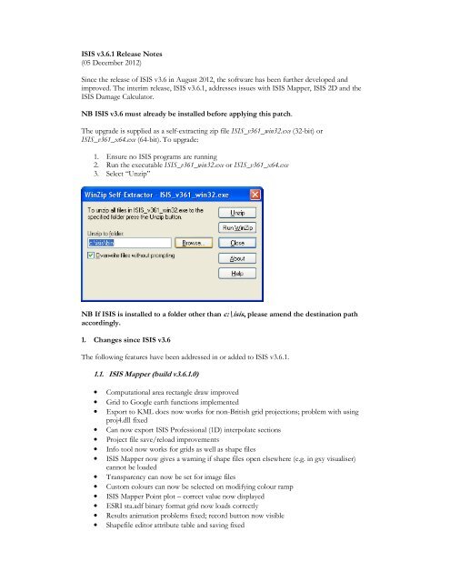
The upgrade is supplied as a self-extracting zip file <strong>ISIS</strong>_v361_win32.exe (32-bit) or<br />
<strong>ISIS</strong>_v361_x64.exe (64-bit). To upgrade:<br />
1. Ensure no <strong>ISIS</strong> programs are running<br />
2. Run the executable <strong>ISIS</strong>_v361_win32.exe or <strong>ISIS</strong>_v361_x64.exe<br />
3. Select “Unzip”<br />
NB If <strong>ISIS</strong> is installed to a folder other than c:\isis, please amend the destination path<br />
accordingly.<br />
1. Changes since <strong>ISIS</strong> v3.6<br />
The following features have been addressed in or added to <strong>ISIS</strong> v3.6.1.<br />
<strong>1.1.</strong> <strong>ISIS</strong> <strong>Mapper</strong> (<strong>build</strong> <strong>v3.6.1.0</strong>)<br />
• Computational area rectangle draw improved<br />
• Grid to Google earth functions implemented<br />
• Export to KML does now works for non-British grid projections; problem with using<br />
proj4.dll fixed<br />
• Can now export <strong>ISIS</strong> Professional (1D) interpolate sections<br />
• Project file save/reload improvements<br />
• Info tool now works for grids as well as shape files<br />
• <strong>ISIS</strong> <strong>Mapper</strong> now gives a warning if shape files open elsewhere (e.g. in gxy visualiser)<br />
cannot be loaded<br />
• Transparency can now be set for image files<br />
• Custom colours can now be selected on modifying colour ramp<br />
• <strong>ISIS</strong> <strong>Mapper</strong> Point plot – correct value now displayed<br />
• ESRI sta.adf binary format grid now loads correctly<br />
• Results animation problems fixed; record button now visible<br />
• Shapefile editor attribute table and saving fixed
• <strong>ISIS</strong> model file display fixed<br />
• Cross-section and reservoir extension tool now working<br />
• Reverse feature points and rotate cross-section are now working<br />
• Import CSV and XYZ formats fixed<br />
• Editing and triangulating <strong>ISIS</strong> cross section and export to shape file now working<br />
• Generate/assign river centre line issues fixed<br />
• 1D-2D link line generator fixed<br />
• <strong>ISIS</strong> <strong>Mapper</strong> 1D and 2D calculator output errors corrected<br />
• Pressing F1 no longer causes a GPF error<br />
• Fixed vertical scroll bar in Modelling toolbox<br />
• <strong>ISIS</strong> <strong>Mapper</strong> 2D “flow” results display fixed<br />
• Second and subsequent polygon display fixed on creating new shape file<br />
• <strong>ISIS</strong> 2D computational area now saves properly<br />
1.2. <strong>ISIS</strong> 2D (<strong>build</strong> v3.6.1.282)<br />
• Hazard class and Courant Number output corrections<br />
• Revised <strong>ISIS</strong>2D_to_asc – velocity direction output and preventing of cropped portions<br />
of output<br />
• Run until converged option – allows simulation to terminate once equilibrium has been<br />
reached<br />
• Build number exported to log<br />
1.3. <strong>ISIS</strong> Damage Calculator (<strong>build</strong> v3.6.1.19)<br />
• Fixed problem where MCM codes beginning with '9' were all treated as ‘9’, e.g. ‘939’<br />
would use the same damage value as ‘9’.<br />
• Fixed problem with property dataset field mappings, where duplicate mappings were<br />
sometimes created and saved with the project.