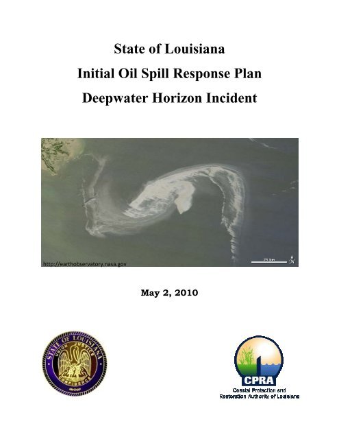
State of Louisiana Initial Oil Spill Response Plan - Coastal ...
State of Louisiana Initial Oil Spill Response Plan - Coastal ...
State of Louisiana Initial Oil Spill Response Plan - Coastal ...

You also want an ePaper? Increase the reach of your titles
YUMPU automatically turns print PDFs into web optimized ePapers that Google loves.
<strong>State</strong> <strong>of</strong> <strong>Louisiana</strong><br />
<strong>Initial</strong> <strong>Oil</strong> <strong>Spill</strong> <strong>Response</strong> <strong>Plan</strong><br />
Deepwater Horizon Incident<br />
http://earthobservatory.nasa.gov<br />
May 2, 2010
In an effort to assist the removal <strong>of</strong> oil from our coastal waters, minimize the interface <strong>of</strong> oil and<br />
<strong>Louisiana</strong>’s fragile coastal wetlands, marine wildlife and the communities and economies<br />
embedded therein, the <strong>State</strong> <strong>of</strong> <strong>Louisiana</strong> provides the following initial near-shore action plan<br />
and requests that it be implemented immediately. This plan was developed in coordination with<br />
affected coastal parishes. The action is feasible and cost effective when considering the potential<br />
damage that threatens our coast. The central tenet <strong>of</strong> this plan is immediate and robust action<br />
supported by the people <strong>of</strong> <strong>Louisiana</strong> who stand ready, willing, and able to assist in anyway to<br />
protect their lives and livelihoods.<br />
The state requests that all relevant training be conducted at designated sites identified herein.<br />
These training efforts should be authorized immediately and coordinated directly with coastal<br />
parishes. Training shall include: financial management under OPA90, relevant regulatory and<br />
legal guidelines, material handling, boom deployment and monitoring, oil collection protocols,<br />
and active containment strategies (containment strategies as a second line <strong>of</strong> defense) to all<br />
interested people. Training shall be <strong>of</strong>fered coast wide in Chalmette, Belle<br />
Chasse, Slidell, Houma, Golden Meadow, Morgan City, Abbeville, and Lake Charles.<br />
A concurrent action following approval <strong>of</strong> this plan is to immediately deploy booms (per the<br />
Boom Measure described below) in all <strong>of</strong> the areas identified in Appendix 1 from the mouth <strong>of</strong><br />
the Mississippi River to the <strong>Louisiana</strong>-Mississippi <strong>State</strong> line. We request that coastal parishes be<br />
authorized to lead and direct boom deployment within their respective jurisdictions. These<br />
deployment strategies may consist <strong>of</strong>: parish deployment, parish contractors (including trained<br />
fishing fleets), invoicing directly to BP, BP contractors operating under parish direction, or<br />
parishes delegating deployment to BP.<br />
Teams charged with these deployments should utilize the human resources and vessels available<br />
through trained citizens and volunteers in coordination with the <strong>Louisiana</strong> Department <strong>of</strong><br />
Wildlife and Fisheries. This workforce is available for deployment efforts, to aid in logistics,<br />
transport <strong>of</strong> materials to and from the boom deployment sites, as well as monitoring and<br />
operations <strong>of</strong> sites as appropriate.<br />
Additional plan elements including Shoreline Cleanup Assessment Team (SCAT) deployment,<br />
oil clean up, and remediation and environmental assessment, are to be implemented as directed<br />
by the Unified Command in concert with the above measures.<br />
Local knowledge, the experience and expertise <strong>of</strong> <strong>Oil</strong> <strong>Spill</strong> <strong>Response</strong> Organizations (OSRO), and<br />
the latest intelligence information on oil location and forecasts will drive the location and<br />
intensity <strong>of</strong> activity. It is assumed that the logistics and coordination will be executed by the<br />
OSRO tasked with the effort. However, the <strong>State</strong> stands ready to assist if any issues arise that<br />
may slow the pace <strong>of</strong> this much-needed and delayed response. All <strong>of</strong> this will ensure that the<br />
response is as efficient and effective as possible and allow for rapid reaction to changing<br />
conditions.<br />
2
Introduction<br />
On April 20, 2010, an explosion occurred on the semisubmersible drilling platform Deepwater<br />
Horizon during deepwater drilling activities on the outer continental shelf southeast <strong>of</strong> the<br />
Mississippi River bird’s-foot delta. Two days later, as fire-fighting activities continued, the<br />
Deepwater Horizon sank into the Gulf <strong>of</strong> Mexico. Shortly thereafter, it was determined that the<br />
drilling assembly was leaking raw petroleum at an estimated 5,000 barrels (approximately<br />
210,000 gallons) per day into the northern Gulf. That leak continues as <strong>of</strong> the writing <strong>of</strong> this<br />
report. Current well conditions remain dynamic. According to BP, the well has the capacity to<br />
produce a maximum <strong>of</strong> 110,000 to 164,000 barrels per day. In addition, it is also understood that<br />
a relief well, including a 90-day drill time, will be an integral part <strong>of</strong> efforts to cap the well. The<br />
continuing oil spill currently threatens priceless ecological, cultural, recreational and economic<br />
resources <strong>of</strong> the states <strong>of</strong> <strong>Louisiana</strong>, Mississippi, Alabama, and Florida.<br />
As a result, significant <strong>State</strong> resources have been mobilized to respond to the event. Several<br />
agencies <strong>of</strong> the <strong>State</strong> <strong>of</strong> <strong>Louisiana</strong> have been involved, including the following:<br />
<br />
<br />
<br />
<br />
<br />
<br />
<br />
<br />
<br />
<br />
<br />
<br />
<br />
Office <strong>of</strong> <strong>Coastal</strong> Protection and Restoration (CPRA’s implementation arm)<br />
Department <strong>of</strong> Environmental Quality,<br />
Department <strong>of</strong> Natural Resources,<br />
Department <strong>of</strong> Wildlife and Fisheries,<br />
Department <strong>of</strong> Transportation and Development,<br />
<strong>Louisiana</strong> Recovery Authority,<br />
<strong>Louisiana</strong> Workforce Commission,<br />
Department <strong>of</strong> Health and Hospitals,<br />
Department <strong>of</strong> Transportation and Development,<br />
Department <strong>of</strong> Economic Development,<br />
<strong>State</strong> Police,<br />
Office <strong>of</strong> Homeland Security and Emergency Preparedness, and<br />
<strong>Oil</strong> <strong>Spill</strong> Coordinator’s Office.<br />
Relevant resources agencies met to develop a joint plan considering many factors, including:<br />
<strong>Louisiana</strong>’s most sensitive coastal resources, potential spill impacts, deployment schedules and<br />
resource considerations. This plan presents a set <strong>of</strong> recommended actions based on current<br />
information, agency discussions and parish input. The <strong>State</strong>’s hope is that the Incident<br />
Command Structure will consider this plan for incorporation into the Incident Action <strong>Plan</strong> (IAP).<br />
These actions outline a series <strong>of</strong> steps, intended to be taken in coordination with those already<br />
identified/approved by the state and coastal parishes and those in the IAP that will support the<br />
Unified Command’s strategy <strong>of</strong> keeping the oil spill away from <strong>Louisiana</strong>’s sensitive coastal<br />
areas.<br />
The majority <strong>of</strong> this document describes necessary action to keep the oil spill from entering<br />
<strong>Louisiana</strong>’s coastal wetlands, based on the assumption that removal <strong>of</strong> the released oil will be<br />
much easier and less damaging to fragile coastal ecosystems if done in the open waters <strong>of</strong> the<br />
3
much easier and less damaging to fragile coastal ecosystems if done in the open waters <strong>of</strong> the<br />
Gulf <strong>of</strong> Mexico. Should that measure not be successful, this report adopts a multiple lines <strong>of</strong><br />
defense strategy to minimize the extent <strong>of</strong> oil penetration into the coastal wetlands. Finally, this<br />
plan focuses on the areas (i.e., parishes) <strong>of</strong> the <strong>State</strong> that have immediate needs, or are likely to<br />
have impacts in the near term. We will continue to develop supplemental plans addressing the<br />
needs <strong>of</strong> interior parishes. These supplemental efforts will focus on situations where the<br />
perimeter measures are overwhelmed, and/or the oil penetrates inland.<br />
Action <strong>Plan</strong> Sequence<br />
Immediate<br />
• Immediately deploy booms at all critical locations east <strong>of</strong> river as shown on maps<br />
included in Appendix 1 (by region) and Appendix 2-12 (by parish).<br />
o Utilize local fishing fleets and fishermen for transport, monitoring and<br />
deployment <strong>of</strong> boom.<br />
• Establish regional staging areas for supplies.<br />
o Order and begin to store necessary supplies assuming extensive, long-lasting oil<br />
removal.<br />
• Inventory, identify and organize multiple shore bases.<br />
o Prepare shore bases to store and handle recovery materials.<br />
o Organize pr<strong>of</strong>essional, contract, and volunteer teams.<br />
• Train local fisherman and others to be involved in clean up effort.<br />
o Training should include material handling, implementation <strong>of</strong> secondary and<br />
tertiary prevention techniques, boom deployment and monitoring, and oil<br />
collection protocols.<br />
As Soon as <strong>Oil</strong> Has the Potential to be within 5 Miles <strong>of</strong> <strong>Coastal</strong> Areas<br />
• Establish booms in coastal areas as identified in appendices.<br />
• Ready local teams for deployment.<br />
72 to 36 Hours Prior to <strong>Oil</strong> Predicted to be within 5 miles <strong>of</strong> Land<br />
• Stock implementation site/marinas.<br />
• Deploy local teams to implement secondary and tertiary prevention measures.<br />
36 Hours to Landfall and Ongoing<br />
• Analyze and continue flow <strong>of</strong> supplies to staging areas and implementation sites.<br />
• Continue management <strong>of</strong> local prevention teams and booms.<br />
• Continue implementation <strong>of</strong> secondary and tertiary prevention measures.<br />
• Active strategies for successive lines <strong>of</strong> defense.<br />
4
Action <strong>Plan</strong> Measures<br />
Dispersants<br />
The decision to apply dispersants in near-shore waters is time-sensitive and complex. Given the<br />
potential impacts that dispersed oil may have on water-column and seafloor biota and habitats,<br />
thoughtful consideration is required prior to use <strong>of</strong> this technology relative to the potential<br />
impacts with and without dispersant application. The trade-<strong>of</strong>fs in use <strong>of</strong> dispersants are a<br />
complex interplay <strong>of</strong> many variables, including the type <strong>of</strong> oil spilled, the volume <strong>of</strong> the spill, sea<br />
state, weather, water depth, degree <strong>of</strong> turbulence (thus mixing and dilution <strong>of</strong> the oil), and<br />
relative abundance and life stages <strong>of</strong> resident organisms. Some key points associated with<br />
trade<strong>of</strong>fs that were considered in formulating the recommendations include: (1) oil spill<br />
dispersants do not actually reduce the total amount <strong>of</strong> oil entering the environment but do allow<br />
much faster bioremediation and removal from the surface; (2) mixing <strong>of</strong> the water column<br />
nearshore with waves and tides may actually mix oil naturally and disperse oil into the water<br />
column, particularly after aging for more than 7 days; (3) the nearshore shallow environment has<br />
some <strong>of</strong> the most productive fisheries in the world; and (4) the muddy environments have a<br />
microbial capacity to naturally decompose many <strong>of</strong> the oil products that contaminate wetlands<br />
(particularly with some enhancements).<br />
Dispersant Measure 1: Focus use <strong>of</strong> dispersants greater than 3 nautical miles (roughly 5<br />
kilometers ) from the shoreline and in water depths greater than 33 feet (10 meters).<br />
Dispersant Measure 2 (near-shore): Determine the effectiveness <strong>of</strong> dispersal use between this<br />
3-mile limit and the shoreline (in water depths greater than 10 meters) by utilizing field test as to<br />
effectiveness.<br />
Dispersant Measure 3 (near-shore): Refrain from using dispersants along shoreline, in<br />
wetlands, or in water less than 10 meters deep.<br />
Booms<br />
While the existing frontal marsh/coastline <strong>of</strong> <strong>Louisiana</strong> will no doubt be adversely impacted by<br />
interaction with the oil spill, it is imperative that we prevent the oil from being carried into the<br />
fragile interior marshes. There are numerous specific critical areas (gaps, chokepoints, etc.) along<br />
the marsh edge that have been identified as strategically located for deployment <strong>of</strong> boom<br />
measures to minimize the entrance <strong>of</strong> the oil into the interior marsh areas. These locations are<br />
provided in Appendix A by region and are listed by parish in Appendix B. OSRO entities are to<br />
be deployed to the areas within the projected landfall threat zone to install booms and sorbent<br />
matting. These units would consist <strong>of</strong> an OSRO advisor, a HazMat-trained supervisor, associated<br />
HazMat-trained personnel, and the resources required to manage and maintain these locations. A<br />
state regulatory agency oversight representative will also be assigned to monitor a site or group<br />
<strong>of</strong> sites to provide feedback to planning on implementation, effectiveness, and additional needs.<br />
5
For this initial phase, it is estimated that approximately 760,000 linear feet <strong>of</strong> boom would be<br />
needed to adequately implement and maintain this initial near-shore plan. This includes a<br />
number <strong>of</strong> identified critical areas located throughout the <strong>Louisiana</strong> coast, from the Mississippi<br />
<strong>State</strong> line at the Pearl River to Sabine Pass at the Texas <strong>State</strong> line.<br />
The effectiveness <strong>of</strong> implementing booming strategies will depend on site-specific conditions,<br />
such as water velocities, tidal influence, wind speed, and wave height. As such, each site will<br />
require site-specific placement and maintenance strategies that have the flexibility to adapt to<br />
changing weather, site, and impact-threat conditions as determined by the assigned OSRO<br />
advisor in accordance with industry-accepted Best Management Practices. It is critical that all<br />
local resources (parish <strong>of</strong>ficials, local fishermen, etc.) be consulted and utilized for the<br />
identification <strong>of</strong> likely oil collection points, potential areas <strong>of</strong> need, and additional areas <strong>of</strong><br />
concern.<br />
As stated, boom measures will be site specific. However, at a minimum, the OSRO should<br />
consider the following measures and materials.<br />
Towed Boom Measures: U-booming, two boats required; V-booming two tow boats, one<br />
skimming vessel; and J-booming, one tow boat, one tow/skimming vessel.<br />
Anchored Boom Measures: U-booming, anchors at upstream ends; deflection booming (more<br />
typical), requires adequate number and size <strong>of</strong> anchors to keep the boom in longitudinal tension<br />
in order to avoid scalloping and subsequent loss <strong>of</strong> oil due to entrainment, deployed boom must<br />
be tended periodically to maintain effectiveness as environmental conditions change.<br />
Barge Boom Measures: For larger waterways with widths not manageable by booms alone (such<br />
as the Rigolets) locally available barges could be put in place, loaded to increase depths <strong>of</strong> drafts,<br />
and configured in an appropriate exclusion or deflection booming strategy as dictated by site<br />
conditions.<br />
Types <strong>of</strong> Retention Booms: Internal foam flotation boom; self-inflating boom; pressure-inflatable<br />
boom; fence boom; shore-sealing boom; sorbent boom.<br />
Sorbents<br />
To supplement the booming activities, sorbent materials (booms, pads, and/or loose material)<br />
will be used to collect the initial amounts <strong>of</strong> oil encountered and will be managed onsite to<br />
minimize the amounts <strong>of</strong> oil that may penetrate the booms. Sorbent booms or pads have low<br />
capacity but very high efficiency. As such, total amounts <strong>of</strong> needed sorbent will depend highly<br />
on the amounts <strong>of</strong> oil encountered at each site and must be replaced when sorbency limits are<br />
reached. Sorbent boom is intended for use in areas too small or sensitive for other skimmers.<br />
Sorbent types actually applied will be tailored to parochial conditions. Additional quantity<br />
information is provided in Appendix 1.<br />
6
Spud Barges<br />
Spud barges are to be stationed across the coast to serve as mobile field bases. The 20 barges are<br />
capable <strong>of</strong> transporting materials necessary for the incident, as well as providing food and shelter<br />
for the OSRO and SCAT teams and first aid as necessary. Being mobile, these barges are to be<br />
deployed as conditions change and areas <strong>of</strong> critical need shift.<br />
Training<br />
All persons involved in executing this plan shall have the appropriate level <strong>of</strong> training<br />
commensurate with their role. Each boom deployment and response site will have a supervisor<br />
that has necessary 40-hour HAZWOPR and 8-hour HAZWOPR Supervisory training. While<br />
many <strong>of</strong> the OSRO have extensive training, the large number <strong>of</strong> interested citizens (e.g.,<br />
commercial fisherman) and volunteers will be required to have the minimum 4-hour oil spill<br />
safety training. Training will be provided in coastal communities throughout <strong>Louisiana</strong><br />
immediately. This will be organized by BP and the Coast Guard in coordination with the state<br />
and coastal parishes as needed to provide the maximum number <strong>of</strong> people with training as<br />
quickly as possible.<br />
Secondary and Tertiary Lines <strong>of</strong> Defense<br />
If oil is to overwhelm the booms and enter the interior wetlands, additional actions must be taken<br />
immediately to limit the damage; these actions are considered secondary and tertiary lines <strong>of</strong><br />
defense. SCAT will continually monitor the wetlands to report any areas that are being<br />
damaged. Supplemental plans involving successive lines <strong>of</strong> defense are under development.<br />
Assessment<br />
It is critical that areas potentially adversely affected by oil from this spill are assessed to<br />
determine removal techniques, the extent <strong>of</strong> damage to the wetlands, wetland-dependant species,<br />
aquatic habitats, and aquatic organisms. This will involve near-term and long-term monitoring<br />
and restoration and remediation plans. The damage to infrastructure must also be assessed.<br />
7
Appendices<br />
Appendix 1……………….Combined Maps and <strong>Plan</strong>s<br />
Appendix 2……………….Orleans Parish<br />
Appendix 3……………….Plaquemines Parish<br />
Appendix 4……………….St. Bernard Parish<br />
Appendix 5……………….St. Tammany Parish<br />
Appendix 6……………….Cameron/Calcasieu Parishes<br />
Appendix 7……………….Iberia Parish<br />
Appendix 8……………….Jefferson Parish<br />
Appendix 9……………….Lafourche Parish<br />
Appendix 10……………...St. Mary Parish<br />
Appendix 11……………...Terrebonne Parish<br />
Appendix 12………………Vermillion Parish
Appendix 1: Combined Maps and <strong>Plan</strong>s
East <strong>of</strong> River (includes all <strong>of</strong> Plaquemines Parish)<br />
Parish<br />
Closure Points<br />
Total Width<br />
(ft)<br />
Boom Length*<br />
(ft)<br />
Secondary and<br />
Tertiary<br />
Prevention<br />
Length** (ft)<br />
Secondary<br />
and Tertiary<br />
Materials<br />
Mobile<br />
Deployment<br />
Sites<br />
Number <strong>of</strong><br />
Teams Staging Areas Shore Bases Training Sites Cost Per Parish<br />
Orleans 4 3,144 14,148 3,537 259 0 2 1 1 0 $7,004,344<br />
Plaquemines 45 22,912 103,104 25,776 2912 4 15 2 3 1 $55,676,459<br />
St. Bernard 31 16,413 73,859 18,465 2006 3 11 1 2 1 $40,580,536<br />
St Tammany 2 2,439 10,976 2,744 129 0 1 1 1 1 $4,461,166<br />
Subtotal 82 44,908 202,086 50,522 5306 7 29 5 7 3<br />
Cost (30 days) $25,260,750 $7,578,225 $3,183,529 $5,250,000 $65,250,000 $125,000 $175,000 $900,000 $107,722,504<br />
Approximate Daily Rate $3,590,750<br />
West Side <strong>of</strong> River (Excluding Plaquemines Parish)<br />
Parish<br />
Closure Points<br />
Total Width<br />
(ft)<br />
Boom Length*<br />
(ft)<br />
Secondary and<br />
Tertiary<br />
Prevention<br />
Length** (ft)<br />
Secondary<br />
and Tertiary<br />
Materials<br />
Mobile<br />
Deployment<br />
Sites<br />
Number <strong>of</strong><br />
Teams Staging Areas Shore Bases Training Sites Cost Per Parish<br />
Cameron/Calcasieu 4 4,844 21,798 5,450 259 0 2 1 2 1 $8,572,469<br />
Iberia 8 12,454 56,043 14,011 518 1 3 1 1 0 $16,967,576<br />
Jefferson 3 6,104 27,468 6,867 194 0 1 0 1 0 $6,855,021<br />
Lafourche 30 10,136 45,612 11,403 1941 3 10 2 2 1 $33,726,656<br />
St. Mary 5 3,419 15,386 3,846 324 2 2 1 1 1 $9,044,261<br />
Terrebonne 54 40,015 180,068 45,017 3494 5 18 1 3 1 $76,007,439<br />
Vermilion 18 14,530 65,385 16,346 1165 2 6 1 2 1 $26,698,886<br />
Subtotal 122 91,502 411,759 102,940 7894 13 42 7 12 5<br />
Cost (30 days) $51,469,875 $15,440,963 $4,736,471 $9,750,000 $94,500,000 $175,000 $300,000 $1,500,000 $177,872,308<br />
Approximate Daily Rate $5,929,077<br />
Total Cost (30 days) $76,730,625 $23,019,188 $7,920,000 $15,000,000 $159,750,000 $300,000 $475,000 $2,400,000 $285,594,813<br />
Approximate Daily Rate $9,519,827<br />
Cost Calculation Assumptions<br />
Containment Boom per Linear Foot $125<br />
Secondary and Tertiary Prevention per Linear Foot $150<br />
Secondary and Tertiary Materials $600<br />
Mobile Deployment Sites (Spud Barges) per day $25,000<br />
SCAT Teams, Per Day $75,000<br />
Staging Areas, Per Month $25,000<br />
Shore Bases, Per Month $25,000<br />
Training Sites, Per Site $300,000<br />
Costs assume 30‐day costs <strong>of</strong> response operations<br />
*Assuming 3 Booms per location and 1.5 factor for curvature<br />
**Assuming need about 1/4 <strong>of</strong> solid boom legth
PROPOSED POINTS OF PROTECTION<br />
PLANNING UNIT 2<br />
157<br />
156<br />
±<br />
158<br />
159<br />
163<br />
160<br />
161<br />
34<br />
162<br />
Lake Borgne<br />
Bobs Lakes<br />
32<br />
33<br />
Lake<br />
Eugenie<br />
31<br />
29<br />
56<br />
30<br />
57<br />
Lake Salvador<br />
Gulf IntracoastalWaterway<br />
Bayou<br />
Perot<br />
Bayou<br />
Rigolettes<br />
Lake<br />
Lery<br />
8<br />
63<br />
5<br />
6<br />
7<br />
64<br />
60 18<br />
17<br />
Lake<br />
Jean<br />
Louis<br />
Robin<br />
12 13<br />
9<br />
61<br />
11<br />
10<br />
16<br />
14<br />
Bay Gardene<br />
MRGO<br />
19<br />
Lake Coquille<br />
Lake Calebasse<br />
15<br />
20<br />
Black Bay<br />
21<br />
22<br />
23<br />
28<br />
Flat<br />
Bay<br />
24<br />
Lake Eloi<br />
27 58<br />
26<br />
59<br />
Lake Athanasio<br />
25<br />
Eloi Bay<br />
Little Lake<br />
Lake<br />
Round Laurier<br />
Lake<br />
45<br />
46<br />
Mud<br />
Lake<br />
Wilkinson<br />
Bay<br />
149<br />
44 43<br />
40<br />
42<br />
41<br />
Bayou<br />
151<br />
152<br />
Mississippi River<br />
39<br />
Grande<br />
Cheniere<br />
BAY<br />
148 SANSBOIS<br />
36<br />
62<br />
65<br />
35<br />
66<br />
4<br />
67<br />
3<br />
Long Bay<br />
2 1<br />
0<br />
**DRAFT May 2, 2010<br />
6 3 0 6 Miles<br />
Middle Fork Bayou L'ours<br />
Hackberry Bay
tracoastal<br />
Bayou<br />
Perot<br />
Little Lake<br />
Bayou<br />
PROPOSED POINTS OF PROTECTION<br />
Rigolettes<br />
PLANNING UNIT 2<br />
Mud<br />
Lake<br />
Round<br />
Lake<br />
46<br />
Lake<br />
Laurier<br />
45<br />
44<br />
43<br />
42<br />
41<br />
Bayou<br />
Mississippi River<br />
39 38<br />
151<br />
37<br />
150<br />
36<br />
Wilkinson<br />
152<br />
Bay<br />
BAY<br />
149 148 SANSBOIS<br />
40<br />
Grande Cheniere<br />
7<br />
5<br />
63<br />
64<br />
62<br />
65<br />
66<br />
35<br />
4<br />
Bay Gardene<br />
3<br />
67<br />
Long Bay<br />
2<br />
1<br />
0<br />
53<br />
52<br />
51 50 49 48<br />
Middle Fork Bayou L'ours<br />
Hackberry Bay<br />
146<br />
145<br />
147<br />
Adams<br />
Barataria Bay<br />
Bay<br />
54<br />
165<br />
166<br />
164<br />
Bay Pomme D'or<br />
Yellow Cotton<br />
Bay<br />
136<br />
Bayou Laf ourche<br />
137<br />
167<br />
168<br />
169<br />
170<br />
55<br />
171<br />
173 172<br />
174<br />
Southwest <strong>Louisiana</strong> Canal<br />
144<br />
143<br />
140<br />
139<br />
141<br />
142<br />
±<br />
4<br />
West Bay<br />
**DRAFT May 2, 2010<br />
2 0 4 Miles
84<br />
PROPOSED POINTS OF PROTECTION<br />
SIX MILE LAKE<br />
86<br />
ATCHAFALAYA BAY<br />
PLANNING UNIT 3a<br />
85<br />
154<br />
155<br />
89<br />
91 94<br />
90<br />
87<br />
88<br />
93 92<br />
96 97<br />
98 99<br />
95<br />
100 105 104<br />
110<br />
108 109<br />
106 107<br />
133<br />
135<br />
126 132<br />
138<br />
119 124 128 129<br />
131<br />
130 134<br />
121 125 127<br />
112 123<br />
117<br />
101<br />
103<br />
Lake Salvador<br />
Waterway<br />
Bayou<br />
Perot<br />
Bayou<br />
Gulf Intracoastal<br />
137<br />
136<br />
Bayou Lafourche<br />
54<br />
139<br />
140<br />
Rigolettes<br />
Little Lake<br />
52 53 51 49 47<br />
141<br />
Southwest <strong>Louisiana</strong> Canal<br />
55<br />
142<br />
Lake<br />
Lery<br />
Lake<br />
Round<br />
Laurier<br />
43<br />
Lake<br />
42<br />
46 45 40 41<br />
Mud<br />
Lake<br />
Middle Fork Bayou L'ours<br />
172<br />
50<br />
164<br />
165<br />
167<br />
169<br />
174<br />
173<br />
Hackberry Bay<br />
143<br />
Wilkinson<br />
Bay<br />
149<br />
Bayou<br />
Barataria Bay<br />
144<br />
Mississippi River<br />
Cheniere<br />
Grande<br />
17<br />
39 BAY 35<br />
SANSBOIS<br />
152<br />
148<br />
146<br />
60<br />
13<br />
61<br />
Lake<br />
Jean<br />
Louis<br />
Robin<br />
8 6 11<br />
7 9<br />
10<br />
5<br />
64<br />
65<br />
63<br />
4<br />
66<br />
67 3<br />
Bay Gardene<br />
1<br />
16<br />
Long Bay<br />
2<br />
14<br />
147<br />
145<br />
19<br />
MRGO<br />
Lake Coquille<br />
Lake Calebasse<br />
15<br />
Black Bay<br />
0<br />
Lake Eloi<br />
Eloi B<br />
59<br />
Lake Athanasi<br />
21<br />
Adams<br />
Bay<br />
Yellow Cotto<br />
Bay Pomme D'or Bay<br />
±<br />
8<br />
**DRAFT May 2, 2010<br />
4 0 8 Miles
PROPOSED POINTS OF PROTECTION<br />
PLANNING UNIT 3b<br />
186<br />
77<br />
78<br />
79<br />
188<br />
76<br />
187<br />
80<br />
184<br />
81<br />
82<br />
83<br />
SIX MILE LAKE<br />
189<br />
181<br />
183<br />
185<br />
84<br />
182 178<br />
179 180<br />
177<br />
175<br />
176<br />
VERMILION BAY<br />
86<br />
85<br />
153<br />
ATCHAFALAYA BAY<br />
154<br />
155<br />
87<br />
88<br />
95<br />
96<br />
±<br />
5<br />
**DRAFT May 2, 2010<br />
2.5 0 5 Miles<br />
89<br />
90<br />
91<br />
94<br />
93<br />
92
PROPOSED POINTS OF PROTECTION<br />
PLANNING UNIT 4<br />
SABINE<br />
LAKE<br />
CALCASIEU<br />
LAKE<br />
GRAND<br />
LAKE<br />
186<br />
77<br />
78<br />
79<br />
69<br />
68<br />
70<br />
71<br />
73<br />
WHITE<br />
LAKE<br />
72<br />
74<br />
75<br />
76 187<br />
184<br />
189<br />
181<br />
183<br />
185<br />
179 182<br />
176<br />
178 180<br />
177<br />
175<br />
80<br />
VERMILIO<br />
±<br />
8<br />
**DRAFT May 2, 2010<br />
4 0 8 Miles
Appendix 2: Orleans Parish
<strong>Initial</strong> Orleans Parish <strong>Plan</strong> Summary<br />
Secondary and<br />
Parish Closure Points<br />
Total Width<br />
(ft)<br />
Boom Length*<br />
(ft)<br />
Tertiary<br />
Prevention<br />
Length** (ft)<br />
Secondary and<br />
Tertiary Materials<br />
Mobile<br />
Deployment<br />
Sites<br />
Number <strong>of</strong><br />
Teams Staging Areas Shore Bases Training Sites<br />
Cost Per Parish<br />
for 30 days<br />
Orleans 4 3144 14148 3537 259 0 2 1 1 0 $7,004,344<br />
Boom Point Location<br />
PARISH<br />
Point<br />
Width<br />
Opening (Ft)<br />
Point<br />
Description X Coordinate Y Coordinate <strong>Plan</strong>ning Unit Training Sites: Chalmette<br />
Orleans 158 653 Blind Rigolets ‐89.64065735650 30.14355228630 1 Staging Sites: Chalmette<br />
Pass @ Lake<br />
Orleans 159 546 Borgne ‐89.68210162180 30.10733987230 1 Shore Bases: Michoud<br />
Orleans 160 1,203<br />
Chef Menteur<br />
Pass ‐89.77499016590 30.04984030050 1<br />
Bayou Thomas<br />
Orleans 163 742 @ Lake Borgne ‐89.82177653590 30.04223795650 1<br />
Total 3,144
St. Tammany<br />
156<br />
157<br />
158<br />
159<br />
163<br />
160<br />
161<br />
34<br />
St. Bernard<br />
Bobs Lakes<br />
32 31<br />
162<br />
Lake Borgne<br />
33<br />
Lake<br />
Eugenie<br />
29<br />
Jefferson<br />
Plaquemines<br />
PROPOSED POINTS OF PROTECTION<br />
ORLEANS PARISH<br />
**DRAFT May 2, 2010<br />
2 1 0 2 Miles<br />
±<br />
28<br />
Flat<br />
Bay
Appendix 3: Plaquemines Parish
<strong>Initial</strong> Plaquemines Parish <strong>Plan</strong> Summary<br />
Parish Closure Points<br />
Total Width<br />
(ft)<br />
Boom Length*<br />
(ft)<br />
Secondary and<br />
Tertiary<br />
Prevention<br />
Length** (ft)<br />
Secondary and<br />
Tertiary<br />
Materials<br />
Mobile<br />
Deployment<br />
Sites<br />
Number <strong>of</strong><br />
Teams Staging Areas Shore Bases Training Sites<br />
Cost Per Parish<br />
for 30 days<br />
Plaquemines 45 22912 103104 25776 2912 4 15 2 3 1 $55,676,459<br />
Training Sites: Belle Chasse<br />
Staging Sites: Port Sulphur, Pointe a la Hache<br />
Shore Bases: Port Sulphur, Pointe a la Hache, Venice
<strong>Initial</strong> Plaquemines Parish Boom Location<br />
Boom Point Location<br />
PARISH Point<br />
Width<br />
Opening<br />
(Ft) Point Description X Coordinate Y Coordinate <strong>Plan</strong>ning Unit<br />
Plaquemines 0 187 Bayou Lamoque ‐89.55342959350 29.45714587490 1<br />
Plaquemines 1 300 Entrance to Cox Bay ‐89.62185510980 29.48813976250 1<br />
Plaquemines 1 844 Entrance to Cox Bay ‐89.62185510980 29.48813976250 1<br />
Plaquemines 2 265 Upper Grand Bay ‐89.63782486690 29.50102805230 1<br />
Plaquemines 3 874<br />
Entrance south <strong>of</strong> Uhlan<br />
Bay ‐89.66519773740 29.51434175500 1<br />
Plaquemines 4 875 Uhlan Bay ‐89.67583152950 29.53394692220 1<br />
Plaquemines 5 431 Big Four Bayou ‐89.72801672490 29.59222869750 1<br />
Plaquemines 6 326 Bayou Ponton North ‐89.70810296830 29.63827981990 1<br />
Plaquemines 7 135 Bayou Ponton South ‐89.70801427540 29.62369765150 1<br />
Plaquemines 7 120 Bayou Ponton South ‐89.70801427540 29.62369765150 1<br />
Plaquemines 8 327 Bakers Bay NW ‐89.76292141450 29.63456289960 1<br />
Plaquemines 9 464 Bay Lafourche NW ‐89.68729985210 29.62757594000 1<br />
Plaquemines 10 535<br />
Entrance to Bayou<br />
Ponton ‐89.66047068390 29.63761345370 1<br />
Plaquemines 11 417 Entrance near Pintail Flat ‐89.66540378040 29.67389433960 1<br />
Entrance to Lake Cuatro<br />
Plaquemines 12 394 Caballo ‐89.67505110520 29.68343120880 1<br />
Plaquemines 13 356 North Lake Pato Caballo ‐89.66589352780 29.68362587290 1<br />
Plaquemines 35 474<br />
Plaquemines 36 398<br />
Plaquemines 37 166<br />
Plaquemines 38 131<br />
Plaquemines 39 122<br />
Plaquemines 40 132<br />
Plaquemines 41 157<br />
Grand Bayou/(Northern)<br />
Bay Lanaux ‐89.72307206810 29.47420269370 2<br />
Socola Canal Number<br />
Two/Bayou Grande<br />
Cheniere ‐89.74795192780 29.48867321310 2<br />
NE <strong>of</strong> Duhuy, Bayou @<br />
Bayou Grande Cheniere ‐89.75690305810 29.49257440620 2<br />
N <strong>of</strong> Two Sisters Bayou<br />
@ Bayou Grande<br />
Cheniere ‐89.79819766280 29.50087684020 2<br />
S <strong>of</strong> Magnolia <strong>Oil</strong>&Gas fld<br />
@ Bayou Grande<br />
Cheniere ‐89.81765172710 29.49970519870 2<br />
E <strong>of</strong> Bayou Raquette @<br />
Bayou Grande Cheniere ‐89.83938682960 29.52376657650 2<br />
SE <strong>of</strong> Wilkinson Canal @<br />
Bayou Grande Cheniere ‐89.85628200760 29.53385289130 2<br />
Plaquemines 42 267<br />
E <strong>of</strong> Wilkinson Canal @<br />
Bayou Grande Cheniere ‐89.86139901950 29.54470229640 2<br />
Plaquemines 43 299 Hermitage Bayou ‐89.89145432220 29.55375388130 2<br />
Plaquemines 43 484 Hermitage Bayou ‐89.89145432220 29.55375388130 2<br />
Plaquemines 44 1,725<br />
Lake Laurier @<br />
Wilkinson's Bayou ‐89.92573869190 29.55842665610 2<br />
Plaquemines 45 281<br />
Wilkinson's Canal South<br />
<strong>of</strong> Oaks Bayou ‐89.95360695780 29.54416813490 2<br />
Plaquemines 61 337 Inlet to False River ‐89.67458031440 29.66150096060 1<br />
Plaquemines 62 666 Battle Ground Bay ‐89.71958400000 29.58225731390 1<br />
Plaquemines 63 335 Bullseye Bayou ‐89.72506410450 29.58809635740 1<br />
Plaquemines 64 187 Cow Bayou ‐89.71058859620 29.57705345850 1<br />
Plaquemines 65 253 Bayou Law ‐89.70226023690 29.55604323360 1<br />
Plaquemines 66 342 John Bayou ‐89.69690722460 29.52476179500 1<br />
Plaquemines 67 616 Fucich Bayou ‐89.64743964110 29.50340120520 1<br />
Plaquemines 145 519 Grand Bayou ‐89.67137445200 29.39113896390 2<br />
Plaquemines 146 1,382 Robinson Canal ‐89.76189101980 29.41285244320 2<br />
Plaquemines 146 289 Robinson Canal ‐89.76189101980 29.41285244320 2<br />
Plaquemines 146 1,436 Robinson Canal ‐89.76189101980 29.41285244320 2<br />
Plaquemines 147 378<br />
Bayou Maringouin @<br />
Adams Bay ‐89.65160101470 29.40622759350 2<br />
Plaquemines 148 611 Bayou Dulac ‐89.80426904090 29.45742721170 2<br />
Plaquemines 149 335 Bayou Dupont ‐89.95185942020 29.45965523060 2<br />
Plaquemines 150 1,346 Wilkinson Bayou ‐89.91013364380 29.48378418110 2<br />
Plaquemines 151 873 Petit Bay Chene Fleur ‐89.89091407880 29.49225285290 2<br />
Plaquemines 152 1,521 Pond @ Bay Batiste ‐89.86536343110 29.47626221950 2<br />
Total 22,912
St. Charles<br />
12 13<br />
11<br />
61<br />
14<br />
Lake Calebasse<br />
15<br />
St. Bernard<br />
al<br />
Waterway<br />
8<br />
6<br />
7<br />
9<br />
10<br />
Black Bay<br />
Bayou<br />
Perot<br />
Bayou<br />
Rigolettes<br />
5<br />
63<br />
64<br />
62<br />
Bay Gardene<br />
Little Lake<br />
Jefferson<br />
Mud<br />
Lake<br />
Round<br />
Lake<br />
46<br />
Lake<br />
Laurier<br />
45<br />
44<br />
Wilkinson<br />
Bay<br />
150<br />
43<br />
151<br />
42<br />
41<br />
152<br />
Bayou<br />
40<br />
Mississippi River<br />
39 38<br />
Grande Cheniere<br />
149 148<br />
BAY<br />
SANSBOIS<br />
37<br />
36<br />
35<br />
65<br />
66<br />
4<br />
3<br />
67<br />
Long Bay<br />
2<br />
1<br />
0<br />
53<br />
52<br />
51<br />
Lafourche<br />
Middle Fork Bayou L'ours<br />
49 48 47<br />
Hackberry Bay<br />
146<br />
147<br />
145<br />
Adams<br />
Barataria Bay<br />
Bay<br />
Bayou Lafourche<br />
54<br />
165<br />
166<br />
167<br />
164<br />
PROPOSED POINTS OF PROTECTION<br />
PLAQUEMINES PARISH<br />
Bay Pomme D'or<br />
**DRAFT May 2, 2010<br />
2.5 1.25 0 2.5 Miles<br />
±<br />
Yellow
Appendix 4: St. Bernard Parish
Parish Closure Points<br />
Total Width<br />
(ft) Boom Length* (ft)<br />
Secondary and<br />
Tertiary Prevention<br />
Length** (ft)<br />
Secondary and<br />
Tertiary Materials<br />
Mobile<br />
Deployment<br />
Sites<br />
Number <strong>of</strong><br />
Teams Staging Areas Shore Bases Training Sites<br />
Cost Per Parish<br />
for 30 days<br />
St. Bernard 31 16413 73859 18465 2006 3 11 1 2 1 $40,580,536<br />
Training Sites: Chalmette<br />
Staging Sites: Chalmette<br />
Shore Bases: Port Sulphur, Pointe a la Hache, Venice<br />
<strong>Initial</strong> St. Bernard Parish <strong>Plan</strong> Summary
Boom Point Location<br />
<strong>Initial</strong> St. Bernard Parish Boom Location<br />
PARISH Point<br />
Width<br />
Opening<br />
(Ft) Point Description X Coordinate Y Coordinate <strong>Plan</strong>ning Unit<br />
St. Bernard 15 373 Entrance to Terre aux Boeufs ‐89.57615426710 29.66652328060 1<br />
St. Bernard 161 482 Bayou Bienvenue ‐89.86006053300 30.00220590630 1<br />
St. Bernard 14 278 West Bayou Grande ‐89.62450137290 29.68512683940 1<br />
St. Bernard 16 231 Entrance to canal NE <strong>of</strong> Bottle Bayou ‐89.63964969130 29.70869070750 1<br />
St. Bernard 17 237 Entrance to Bayou Jean Louis Robin ‐89.65552787990 29.74248614820 1<br />
St. Bernard 18 471 Entrance to Spanish Bayou ‐89.63355309380 29.76032319020 1<br />
St. Bernard 18 156 Entrance to Spanish Bayou ‐89.63355309380 29.76032319020 1<br />
St. Bernard 18 125 Entrance to Spanish Bayou ‐89.63355309380 29.76032319020 1<br />
St. Bernard 18 349 Entrance to Spanish Bayou ‐89.63355309380 29.76032319020 1<br />
St. Bernard 19 503 Entrance to Bayou Pisana ‐89.58095744160 29.75674363440 1<br />
St. Bernard 20 271 Lake <strong>of</strong> Second Trees NW ‐89.54930300940 29.74234888790 1<br />
St. Bernard 21 847 Lake <strong>of</strong> Second Trees North ‐89.52426377090 29.74254284920 1<br />
St. Bernard 22 385 Entrance to Bayou Pointe‐en‐Pointe ‐89.47646011880 29.79663932820 1<br />
St. Bernard 23 1,269 West Halfmoon Lake ‐89.46482742160 29.81242120130 1<br />
St. Bernard 24 507 Entrance to Bayou Eloi ‐89.43357138660 29.78228502480 1<br />
St. Bernard 25 247 Bayou la Loutre ‐89.36791992610 29.79791927880 1<br />
St. Bernard 26 1,031 Treasure Pass ‐89.41751832780 29.82349816360 1<br />
St. Bernard 27 663 Bayou Petre ‐89.41117241940 29.84284615390 1<br />
St. Bernard 28 392 Bayou Ramon ‐89.43546906530 29.85140960810 1<br />
St. Bernard 29 628 South Lake Eugenie ‐89.41117935800 29.89616613880 1<br />
St. Bernard 30 825 Bayou Muscle ‐89.38096069530 29.91806092090 1<br />
St. Bernard 31 376 Bayou Redfish ‐89.40540711750 29.96055759520 1<br />
St. Bernard 32 718 Bobs Bayou ‐89.46221164330 29.96279510130 1<br />
St. Bernard 33 364 Flat Bayou ‐89.45082573210 29.95175071370 1<br />
St. Bernard 34 1,130 Bayou Marron ‐89.45551672400 29.99369497570 1<br />
St. Bernard 56 296 Lawson Bay ‐89.38510285640 29.93918658160 1<br />
St. Bernard 57 571 Lake <strong>of</strong> the Mound ‐89.37307602980 29.88835943060 1<br />
St. Bernard 58 185 Christmas Camp Lake ‐89.39344897190 29.83801771210 1<br />
St. Bernard 59 1,735 Lake Athanasio @ MRGO ‐89.47462889740 29.73783875130 1<br />
St. Bernard 60 261 Bayou Batola Bay ‐89.65189450780 29.75802108710 1<br />
St. Bernard 162 507 MRGO @ Bayou Pollett ‐89.84176325890 29.94563095940 1<br />
Total 16,413
159<br />
Orleans<br />
163<br />
160<br />
161<br />
34<br />
162<br />
Lake Borgne<br />
Bobs Lakes<br />
32 31<br />
33<br />
56<br />
Lake<br />
Eugenie<br />
29<br />
30<br />
57<br />
28<br />
Flat<br />
Bay<br />
27<br />
58<br />
26<br />
23<br />
22<br />
25<br />
Lake<br />
Lery<br />
MRGO<br />
Lake Eloi<br />
24<br />
60<br />
18<br />
19<br />
Eloi Bay<br />
17<br />
Lake<br />
Jean<br />
Louis<br />
Robin<br />
16<br />
Lake Coquille<br />
20<br />
21<br />
59<br />
Lake Athanasio<br />
11<br />
12 13<br />
61<br />
14<br />
Lake Calebasse<br />
15<br />
ke<br />
rier<br />
Mississippi Rive<br />
Plaquemines<br />
8<br />
6<br />
7<br />
5<br />
63<br />
64<br />
62<br />
9<br />
10<br />
Bay Gardene<br />
Black Bay<br />
PROPOSED POINTS OF PROTECTION<br />
ST BERNARD PARISH<br />
**DRAFT May 2, 2010<br />
3 1.5 0 3 Miles<br />
±
Appendix 5: St. Tammany Parish
<strong>Initial</strong> St. Tammany Parish <strong>Plan</strong> Summary<br />
Parish Closure Points<br />
Total Width<br />
(ft) Boom Length* (ft)<br />
Secondary and<br />
Tertiary Prevention<br />
Length** (ft)<br />
Secondary and<br />
Tertiary Materials<br />
Mobile<br />
Deployment<br />
Sites<br />
Number <strong>of</strong><br />
Teams Staging Areas Shore Bases Training Sites<br />
Cost Per Parish<br />
for 30 days<br />
St Tammany 2 2439 10976 2744 129 0 1 1 1 1 $4,461,166<br />
Boom Point Location<br />
PARISH<br />
Point<br />
Width<br />
Opening (Ft) Point Description X Coordinate Y Coordinate <strong>Plan</strong>ning Unit Training Sites: Slidell<br />
St Tammany 156 1,250 Pearl River ‐89.58095607150 30.18617577440 1 Staging Sites: Slidell<br />
St. Tammany 157 1,189 West Mouth ‐89.65008452260 30.16219688790 1 Shore Bases: Slidell<br />
Total 2,439
156<br />
LITTLE LAKE<br />
157<br />
THE RIGOLETS<br />
Orleans<br />
158<br />
PROPOSED POINTS OF PROTECTION<br />
ST TAMMANY PARISH<br />
St. Bernard<br />
**DRAFT May 2, 2010<br />
0.3 0.15 0 0.3 Miles<br />
±
Appendix 6 : Cameron/Calcasieu Parishes
<strong>Initial</strong> Cameron Parish and Calcasieu Parish <strong>Plan</strong> Summary<br />
Parish<br />
Closure Points<br />
Total Width<br />
(ft)<br />
Boom<br />
Length* (ft)<br />
Secondary and<br />
Tertiary<br />
Prevention<br />
Length** (ft)<br />
Secondary and<br />
Tertiary Materials<br />
Mobile Deployment<br />
Sites<br />
Number <strong>of</strong><br />
Teams<br />
Staging<br />
Areas<br />
Shore<br />
Bases<br />
Training<br />
Sites<br />
Cost Per Parish<br />
for 30 days<br />
Cameron/Calcasieu 4 4,844 21,798 5,450 259 0 2 1 2 1 $8,572,469<br />
Boom Point Location<br />
PARISH Point<br />
Width<br />
Opening (Ft) Point Description X Coordinate Y Coordinate <strong>Plan</strong>ning Unit<br />
Cameron 68 1,101 Calcasieu Pass ‐93.34436009810 29.76306332830 4<br />
Cameron 70 789 Mermentau ‐93.00990619690 29.72962832240 4<br />
Cameron 71 396 Joseph's Harbor ‐92.76651680450 29.63611022650 4<br />
Cameron 69 2,558 Sabine Pass ‐93.84067307580 29.68900466440 4<br />
Total 4,844<br />
Training Sites: Lake Charles<br />
Staging Sites: Cameron<br />
Shore Bases: Cameron, Grand Chenier, Johnsons Bayou
Acadia<br />
Calcasieu<br />
Jefferson Davis<br />
SABINE<br />
LAKE<br />
CALCASIEU<br />
LAKE<br />
LITTLE LAKE<br />
GRAND<br />
LAKE<br />
Vermilion<br />
68<br />
70<br />
69<br />
THE RIGOLETS<br />
71<br />
73<br />
PROPOSED POINTS OF PROTECTION<br />
CAMERON PARISH<br />
**DRAFT May 2, 2010<br />
4 2 0 4 Miles<br />
±
Appendix 7: Iberia Parish
<strong>Initial</strong> Iberia Parish <strong>Plan</strong> Summary<br />
Secondary and<br />
Parish Closure Points<br />
Total Width<br />
(ft) Boom Length* (ft)<br />
Tertiary<br />
Prevention<br />
Length** (ft)<br />
Secondary and<br />
Tertiary Materials<br />
Mobile<br />
Deployment<br />
Sites<br />
Number <strong>of</strong><br />
Teams Staging Areas Shore Bases Training Sites<br />
Cost Per Parish<br />
for 30 days<br />
Iberia 8 12454 56043 14011 518 1 3 1 1 0 $16,967,576<br />
Boom Point Location<br />
PARISH<br />
Point<br />
Width<br />
Opening (Ft) Point Description X Coordinate Y Coordinate <strong>Plan</strong>ning Unit Training Sites: Abbeville, Morgan City<br />
Iberia 77 350<br />
Avery Canal @<br />
Vermilion Bay ‐91.90842133260 29.83092586300 3b Staging Sites: Port <strong>of</strong> Iberia<br />
Iberia 78 382<br />
Bayou Carlin @<br />
Vermilion Bay ‐91.84835769000 29.83113813860 3b Shore Bases: Port <strong>of</strong> Iberia<br />
Iberia 79 904 GIWW @ Bayou Carlin ‐91.82763229430 29.83240040760 3b<br />
Iberia 80 688 GIWW ‐91.81641005320 29.79286799660 3b<br />
Iberia 186 277<br />
Oaks Canal @<br />
Vermilion Bay ‐91.96525767550 29.83593088330 3b<br />
Iberia 188 575<br />
Bayou Carlin @<br />
Vermilion Bay ‐91.82618706400 29.83105900140 3b<br />
Iberia 175 5,035<br />
Southside <strong>of</strong><br />
Southwest point ‐92.03788024520 29.58342026720 3b<br />
Iberia 176 4,243<br />
Northside <strong>of</strong><br />
Southwest point ‐92.00350868380 29.60992682600 3b<br />
Total 12,454
186<br />
77<br />
78<br />
79<br />
188<br />
80<br />
187<br />
81<br />
82<br />
83<br />
Vermilion<br />
St. Mary<br />
84<br />
VERMILION BAY<br />
176<br />
175<br />
PROPOSED POINTS OF PROTECTION<br />
IBERIA PARISH<br />
**DRAFT May 2, 2010<br />
2 1 0 2 Miles<br />
±
Appendix 8: Jefferson Parish
<strong>Initial</strong> Jefferson Parish <strong>Plan</strong> Summary<br />
Total Width<br />
Secondary and<br />
Boom Length* Tertiary Prevention Secondary and<br />
Mobile<br />
Deployment Number <strong>of</strong><br />
Cost Per Parish<br />
Parish Closure Points (ft)<br />
(ft) Length** (ft) Tertiary Materials Sites Teams Staging Areas Shore Bases Training Sites for 30 days<br />
Jefferson 3 6104 27468 6867 194 0 1 0 1 0 $6,855,021<br />
Boom Point Location<br />
PARISH<br />
Point<br />
Width<br />
Opening (Ft)<br />
Point<br />
Description X Coordinate Y Coordinate <strong>Plan</strong>ning Unit Training Sites: Belle Chasse<br />
Jefferson 143 2,760 Caminada Bay ‐90.04509139420 29.19803143830 2 Staging Sites: Golden Meadow<br />
Jefferson 144 2,692 Barataria Bay ‐89.94911336780 29.26936954040 2 Shore Bases: Grand Isle<br />
Jefferson 46 652<br />
Southern<br />
portion Round<br />
Lake ‐89.98485786890 29.53623876820 2<br />
Total 6,104
144<br />
Lafourche<br />
Plaquemines<br />
G U L F O F M E X I C O<br />
143<br />
PROPOSED POINTS OF PROTECTION<br />
JEFFERSON PARISH<br />
**DRAFT May 2, 2010<br />
0.6 0.3 0 0.6 Miles<br />
±
Appendix 9: Lafourche Parish
<strong>Initial</strong> Lafourche Parish <strong>Plan</strong> Summary<br />
Secondary and<br />
Parish Closure Points<br />
Total Width<br />
(ft) Boom Length* (ft)<br />
Tertiary<br />
Prevention<br />
Length** (ft)<br />
Secondary and<br />
Tertiary Materials<br />
Mobile<br />
Deployment<br />
Sites<br />
Number <strong>of</strong><br />
Teams Staging Areas Shore Bases Training Sites<br />
Cost Per Parish<br />
for 30 days<br />
Lafourche 30 10136 45612 11403 1941 3 10 2 2 1 $33,726,656<br />
Training Sites: Golden Meadow<br />
Staging Sites: Golden Meadow, Fourchon<br />
Shore Bases: Golden Meadow, Fourchon
<strong>Initial</strong> Lafourche Parish Boom Location<br />
Boom Point Location<br />
Width<br />
Opening<br />
PARISH Point (Ft) Point Description X Coordinate Y Coordinate <strong>Plan</strong>ning Unit<br />
Middle Fork Bayou<br />
L'ours (E <strong>of</strong> Yankee<br />
Lafourche 47 197 Canal East) ‐90.09793924230 29.41677909390 2<br />
Lafourche 48 179<br />
Middle Fork Bayou<br />
L'ours @ Yankee Canal<br />
East ‐90.11079793290 29.41801546400 2<br />
Lafourche 49 133<br />
Middle Fork Bayou<br />
L'ours (W <strong>of</strong> Yankee<br />
Canal East) ‐90.12607034560 29.41892006170 2<br />
Lafourche 50 139<br />
Middle Fork Bayou<br />
L'ours (N <strong>of</strong> Enfermer<br />
<strong>Oil</strong>/Gas) ‐90.13936671960 29.42016314080 2<br />
Lafourche 51 160<br />
Lafourche 52 168<br />
West Fork Bayou L'ours<br />
(S <strong>of</strong> King's Canal) ‐90.15674960460 29.42378831960 2<br />
West Fork Bayou L'ours<br />
(SW <strong>of</strong> King's Canal) ‐90.18859840100 29.42599554230 2<br />
Lafourche 53 156<br />
West Fork Bayou L'ours<br />
(SW <strong>of</strong> King's Canal2) ‐90.19600430360 29.42691713040 2<br />
Lafourche 54 439<br />
Bayou Lafourche @ Lake<br />
Jesse (North) ‐90.23591802160 29.33515010400 2<br />
Lafourche 55 525<br />
Leeville Bridge @<br />
Southwest <strong>Louisiana</strong><br />
Canal ‐90.20273985780 29.24876549140 2<br />
Lafourche 134 528 Bay Des Conards ‐90.37227587830 29.29831805970 3a<br />
Lafourche 135 411 Bayou De La Valle ‐90.35376022910 29.34243870970 3a<br />
Lafourche 136 633 Grand Bayou Blue ‐90.25428717850 29.25264586480 3a<br />
Lafourche 137 711<br />
Southwestern <strong>Louisiana</strong><br />
Canal ‐90.25283163530 29.24398566810 3a<br />
Lafourche 138 383 Bayou Courant ‐90.34525106420 29.33413222690 3a<br />
Lafourche 139 446<br />
Grand Bayou @ Gulf Of<br />
Mexico ‐90.24826551550 29.14079264720 3a<br />
Lafourche 140 327<br />
Grand Bayou @ Gulf Of<br />
Mexico ‐90.24536066770 29.14753206670 3a<br />
Lafourche 141 179<br />
Grand Bayou @ Gulf Of<br />
Mexico ‐90.22800991170 29.11652196640 3a<br />
Lafourche 142 1,362 Belle Pass ‐90.22559726740 29.08769485240 2<br />
Lafourche 164 85<br />
Bay Vasier @Judgment<br />
Area ‐90.12485918540 29.32409591460 2<br />
Lafourche 164 111<br />
Bay Vasier @Judgment<br />
Area ‐90.12485918540 29.32409591460 2<br />
Lafourche 165 142 NE <strong>of</strong> Bay Jaque ‐90.14579623310 29.31224791050 2<br />
Lafourche 166 142 NW <strong>of</strong> Bay Jaque ‐90.14955494790 29.30781617280 2<br />
Lafourche 167 170<br />
Intersection <strong>of</strong> Bayou<br />
Ferblanc with pipeline<br />
canal ‐90.14019828940 29.28480278160 2<br />
Lafourche 168 145<br />
Bay Vasier N <strong>of</strong> SW LA<br />
Canal ‐90.11177792570 29.27668417410 2<br />
Lafourche 169 419<br />
Bayou Ferblanc N <strong>of</strong> SW<br />
LA Canal ‐90.13654439350 29.27370405490 2<br />
Lafourche 170 374<br />
SW LA Canal at Bay<br />
Desespere ‐90.10873845200 29.26505577210 2<br />
Lafourche 171 405<br />
Pipeline canal south <strong>of</strong><br />
SW LA Canal ‐90.10918085720 29.24496899400 2<br />
Lafourche 172 94 NW Bay Macoin ‐90.10461562950 29.23217019220 2<br />
Lafourche 173 585 NW Bay Macoin ‐90.10536082400 29.22805569570 2<br />
Lafourche 174 388<br />
Bayou Ferblanc near<br />
Bay Macoin ‐90.10591616100 29.21941765230 2<br />
Total 10,136
53<br />
52<br />
51<br />
Middle Fork Bayou L'ours<br />
50 49 48 47<br />
Hackberry Bay<br />
146<br />
Barataria Bay<br />
135<br />
138<br />
54<br />
164<br />
Terrebonne<br />
131<br />
165<br />
166<br />
Plaquemines<br />
134<br />
Bayou Lafourche<br />
167<br />
136<br />
137<br />
55<br />
Southwest <strong>Louisiana</strong> Canal<br />
169<br />
168<br />
170<br />
171<br />
Jefferson<br />
144<br />
172<br />
173<br />
174<br />
143<br />
140<br />
139<br />
141<br />
142<br />
PROPOSED POINTS OF PROTECTION<br />
LAFOURCHE PARISH<br />
**DRAFT May 2, 2010<br />
2 1 0 2 Miles<br />
±
Appendix 10: St. Mary Parish
<strong>Initial</strong> St. Mary Parish <strong>Plan</strong> Summary<br />
Parish Closure Points<br />
Total Width<br />
(ft) Boom Length* (ft)<br />
Secondary and<br />
Tertiary Prevention<br />
Length** (ft)<br />
Secondary and<br />
Tertiary Materials<br />
Mobile<br />
Deployment<br />
Sites<br />
Number <strong>of</strong><br />
Teams Staging Areas Shore Bases Training Sites<br />
Cost Per Parish<br />
for 30 days<br />
St. Mary 5 3419 15386 3846 324 2 2 1 1 1 $9,044,261<br />
Boom Point Location<br />
PARISH<br />
Point<br />
Width Opening<br />
(Ft) Point Description X Coordinate Y Coordinate <strong>Plan</strong>ning Unit Training Sites: Morgan City<br />
St. Mary 81 309 Atchafalaya Bay ‐91.73840438420 29.75083285750 3b Staging Sites: Morgan City<br />
St. Mary 82 175 Atchafalaya Bay ‐91.69422013750 29.74414452420 3b Shore Bases: Morgan City<br />
St. Mary 83 1,207 The Jaws ‐91.62113042980 29.74865747350 3b<br />
St. Mary 84 512 Atchafalaya Bay ‐91.58617488990 29.64079793020 3b<br />
St. Mary 86 1,216<br />
New Pass @<br />
Atchafalaya Bay ‐91.42929646370 29.54384977440 3b<br />
Total 3,419
St. Martin<br />
81<br />
82<br />
83<br />
SIX MILE LAKE<br />
Assumption<br />
84<br />
Assumption<br />
VERMILION BAY<br />
86<br />
Iberia<br />
85<br />
Terrebonne<br />
153<br />
ATCHAFALAYA BAY<br />
PROPOSED POINTS OF PROTECTION<br />
ST MARY PARISH<br />
154<br />
155<br />
**DRAFT May 2, 2010<br />
2.5 1.25 0 2.5 Miles<br />
±
Appendix 11: Terrebonne Parish
<strong>Initial</strong> Terrebonne Parish <strong>Plan</strong> Summary<br />
Parish Closure Points<br />
Total Width<br />
(ft)<br />
Boom Length*<br />
(ft)<br />
Secondary and<br />
Tertiary<br />
Prevention<br />
Length** (ft)<br />
Secondary and<br />
Tertiary<br />
Materials<br />
Mobile<br />
Deployment<br />
Sites<br />
Number <strong>of</strong><br />
Teams Staging Areas Shore Bases Training Sites<br />
Cost Per Parish<br />
for 30 days<br />
Terrebonne 54 40015 180068 45017 3494 5 18 1 3 1 $76,007,439<br />
Training Sites: Houma<br />
Staging Sites: Houma<br />
Shore Bases: Dularge, Cocodrie, Point‐Aux‐Chenes
Boom Point Location<br />
<strong>Initial</strong> Terrebonne Parish Boom Location<br />
PARISH Point<br />
Width<br />
Opening<br />
(Ft) Point Description X Coordinate Y Coordinate <strong>Plan</strong>ning Unit<br />
Terrebonne 87 594 Blue Hammock Bayou ‐91.03321350170 29.30310145200 3b<br />
Terrebonne 88 1,050 Grand Pass ‐90.93552243930 29.26515983190 3a<br />
Terrebonne 89 656 Oyster Bayou ‐91.13125413850 29.22127123520 3b<br />
Terrebonne 90 900 Bayou De West ‐91.05498030690 29.19345875330 3a<br />
Terrebonne 91 350 East Bay Junop ‐91.04354617840 29.21083029580 3a<br />
Terrebonne 92 2,340 Bayou Grand Caillou ‐90.94042905670 29.17866109000 3a<br />
Terrebonne 93 2,337 Grand Bayou Du Large ‐90.97450216590 29.18808914680 3a<br />
Terrebonne 94 922 Taylors Bayou ‐91.03002262510 29.20450739430 3a<br />
Terrebonne 94 274 Taylors Bayou ‐91.03002262510 29.20450739430 3a<br />
Terrebonne 95 327 Bayou Jones ‐90.87663578690 29.26296902180 3a<br />
Terrebonne 96 530 Bayou Saveur ‐90.86727874270 29.25486065150 3a<br />
Terrebonne 97 402 Bayou Du Nord ‐90.83979644700 29.25442423150 3a<br />
Terrebonne 98 282 Bayou Sale ‐90.82967171690 29.24428711630 3a<br />
Terrebonne 99 995 Bayou Grand Caillou ‐90.81013726870 29.23925398680 3a<br />
Terrebonne 100 577 Trouble Bayou ‐90.80603478980 29.23773609950 3a<br />
Terrebonne 101 737 Houma Navigation Canal ‐90.67119493420 29.23405591990 3a<br />
Terrebonne 102 230 Bayou Petit Caillou ‐90.66151999890 29.24548338750 3a<br />
Terrebonne 102 252 Bayou Petit Caillou ‐90.66151999890 29.24548338750 3a<br />
Terrebonne 103 306 Moss Bay ‐90.68626574880 29.22307253750 3a<br />
Terrebonne 103 174 Moss Bay ‐90.68626574880 29.22307253750 3a<br />
Terrebonne 104 663 Bayou Sale ‐90.72395991420 29.19420066520 3a<br />
Terrebonne 105 390 Bayou Colyell ‐90.77122414280 29.19394206360 3a<br />
Terrebonne 106 2,063 Caillou Bay ‐90.87375544050 29.11736001400 3a<br />
Terrebonne 107 1,197 Pelican Bayou ‐90.81705328800 29.11885083870 3a<br />
Terrebonne 108 2,342 California Bay ‐90.78484719520 29.12621574590 3a<br />
Terrebonne 109 871 Little Misale Bayou ‐90.76023216170 29.12580656500 3a<br />
Terrebonne 110 651 Bayou Sale ‐90.73766880580 29.13881165840 3a<br />
Terrebonne 111 464 Bayou Terrebonne ‐90.61576300040 29.27789077770 3a<br />
Terrebonne 112 343 Bayou Petit Caillou @ Bayou Ter ‐90.63799526590 29.27504446600 3a<br />
Terrebonne 113 121 Bayou Terrebonne ‐90.61064796030 29.31509355140 3a<br />
Terrebonne 114 289 Bayou Terrebonne ‐90.60659583710 29.31360171760 3a<br />
Terrebonne 115 136 Bayou Terrebonne ‐90.60244938220 29.31285146990 3a<br />
Terrebonne 116 291 Bayou La Fleur ‐90.60118369010 29.30762492790 3a<br />
Terrebonne 117 198 Bayou Terrebonne ‐90.59908657130 29.29839609680 3a<br />
Terrebonne 118 258 Bayou Terrebonne ‐90.61326552660 29.30865251330 3a<br />
Terrebonne 119 250 Bayou Terrebonne ‐90.59508087590 29.31016556960 3a<br />
Terrebonne 120 889 Bayou Chitigue ‐90.58528235340 29.31695796840 3a<br />
Terrebonne 121 200 Bayou Terrebonne ‐90.59002397390 29.31286103570 3a<br />
Terrebonne 122 458 Bayou De Mangue ‐90.57385330560 29.31622268350 3a<br />
Terrebonne 123 294 Bayou Dufrene ‐90.56812748680 29.31379536480 3a<br />
Terrebonne 124 148 Bayou Dufrene ‐90.55160695880 29.32447509900 3a<br />
Terrebonne 125 150 Madison Bay ‐90.54464809540 29.32825419050 3a<br />
Terrebonne 126 347 Bayou Barre ‐90.54021962710 29.33269719250 3a<br />
Terrebonne 127 1,194 Lake Tambour ‐90.52761379820 29.30887929150 3a<br />
Terrebonne 128 691 Lake Tambour ‐90.51062348580 29.30825928350 3a<br />
Terrebonne 129 1,254 Lake Tambour ‐90.50059343110 29.30685512970 3a<br />
Terrebonne 130 398 Lake Billiot ‐90.42845749780 29.34979106050 3a<br />
Terrebonne 131 392 Bayou Jean Lacroix ‐90.39678800400 29.31199267420 3a<br />
Terrebonne 132 346 Channel at Lake Felicity ‐90.46048270140 29.33741018070 3a<br />
Terrebonne 133 260 Bayou Leblanc ‐90.44827036040 29.35137120150 3a<br />
Terrebonne 153 468 Palmetto Bayou ‐91.21863236100 29.43775244980 3b<br />
Terrebonne 154 532 Plumb Bayou ‐91.20860200730 29.41497058200 3b<br />
Terrebonne 155 577 Creole Bayou ‐91.20866206970 29.40382558010 3b<br />
Terrebonne 85 6,655 Lower Atchafalaya River ‐91.27390596280 29.48480836150 3b<br />
Total 40,015
85<br />
153<br />
ATCHAFALAYA BAY<br />
St. Mary<br />
154<br />
155<br />
87<br />
126<br />
124<br />
125<br />
122<br />
118 119 123 127 128 129<br />
121<br />
116 120<br />
132<br />
133<br />
130<br />
131<br />
135<br />
134<br />
138<br />
88<br />
95<br />
96<br />
97<br />
98<br />
99<br />
102<br />
112<br />
117<br />
111<br />
Lafourche<br />
89<br />
91<br />
94<br />
90<br />
93<br />
92<br />
100<br />
105 104<br />
103<br />
101<br />
110<br />
106<br />
107<br />
108<br />
109<br />
PROPOSED POINTS OF PROTECTION<br />
TERREBONNE PARISH<br />
**DRAFT May 2, 2010<br />
4 2 0 4 Miles<br />
±
Appendix 12: Vermilion Parish
<strong>Initial</strong> Vermilion Parish <strong>Plan</strong> Summary<br />
Parish Closure Points Total Width (ft) Boom Length* (ft)<br />
Secondary and<br />
Tertiary Prevention<br />
Length** (ft)<br />
Secondary and<br />
Tertiary Materials<br />
Mobile<br />
Deployment<br />
Sites<br />
Number <strong>of</strong><br />
Teams Staging Areas Shore Bases Training Sites<br />
Cost Per Parish<br />
for 30 days<br />
Vermilion 18 14530 65385 16346 1165 2 6 1 2 1 $ 26,698,886<br />
Boom Point Location<br />
PARISH<br />
Point<br />
Width Opening<br />
(Ft) Point Description X Coordinate Y Coordinate <strong>Plan</strong>ning Unit Training Sites: Abbeville<br />
Vermilion 72 229 Rollover Bayou ‐92.53623323520 29.57353537610 4 Staging Sites: Intracoastal City<br />
Vermilion 73 168 Flat Lake ‐92.55764106090 29.58972280260 4 Shore Bases: Intracoastal City, Pecan Island<br />
Vermilion 74 568 Freshwater Bayou ‐92.30764091250 29.54055689830 4<br />
Vermilion 75 552<br />
Freshwater Bayou @<br />
Vermilion Bay ‐92.20521344480 29.75250364100 4<br />
Vermilion 75 1,755<br />
Freshwater Bayou @<br />
Vermilion Bay ‐92.20521344480 29.75250364100 4<br />
Vermilion 76 1,060 GIWW ‐92.13997691110 29.78207285470 4<br />
Vermilion 177 263<br />
West cove <strong>of</strong><br />
Southwest point ‐92.07086037410 29.59439814340 3b<br />
Vermilion 178 63 Hog Bayou ‐92.07849778530 29.62069509970 3b<br />
Vermilion 179 76 Hell Hole Bayou ‐92.09357872750 29.61751099730 3b<br />
Vermilion 180 396 Prien Bayou ‐92.09948388610 29.61170586730 3b<br />
Vermilion 181 185 Redfish Point Bayou ‐92.10363662580 29.69670965490 3b<br />
Vermilion 181 70 Redfish Point Bayou ‐92.10363662580 29.69670965490 3b<br />
Vermilion 182 71 Prien Bayou ‐92.11297474880 29.61800742860 3b<br />
Vermilion 183 205 Fearman Lake Canal ‐92.13316034650 29.67279481570 3b<br />
Vermilion 184 801<br />
Four Mile Canal @<br />
Vermilion bay ‐92.11317536720 29.74241964370 3b<br />
Vermilion 185 77 Canal ‐92.12930998890 29.65355306680 3b<br />
Vermilion 187 134<br />
Boston Canal @<br />
Vermilion Bay ‐92.03543261100 29.78219804410 3b<br />
Vermilion 189 7,857<br />
Mud Point to East <strong>of</strong><br />
Shallow Bayou ‐92.15365922240 29.70855736390 3b<br />
Total 14,530
D<br />
186<br />
76<br />
187<br />
75<br />
184<br />
WHITE<br />
LAKE<br />
189<br />
Cameron<br />
181<br />
183<br />
St. Mary<br />
185<br />
182<br />
179<br />
180<br />
178<br />
176<br />
Iberia<br />
73<br />
177<br />
175<br />
72<br />
74<br />
PROPOSED POINTS OF PROTECTION<br />
VERMILION PARISH<br />
**DRAFT May 2, 2010<br />
3 1.5 0 3 Miles<br />
±