barrier island status report - Coastal Protection and Restoration ...
barrier island status report - Coastal Protection and Restoration ...
barrier island status report - Coastal Protection and Restoration ...

You also want an ePaper? Increase the reach of your titles
YUMPU automatically turns print PDFs into web optimized ePapers that Google loves.
BARRIER ISLAND STATUS REPORT<br />
Fiscal Year 2014 Annual Plan<br />
1.0 Introduction<br />
In compliance with Act 297 of the 2006 Regular Legislative Session, the <strong>Coastal</strong> <strong>Protection</strong> <strong>and</strong><br />
<strong>Restoration</strong> Authority (CPRA) provides this <strong>barrier</strong> <strong>isl<strong>and</strong></strong> <strong>status</strong> <strong>report</strong> as part of the Annual<br />
Plan document, which will be submitted to each member of the Louisiana Legislature. The act<br />
requires that the <strong>report</strong> indicate: 1) the condition of all <strong>barrier</strong> <strong>isl<strong>and</strong></strong>s, 2) provide the <strong>status</strong> of all<br />
<strong>barrier</strong> <strong>isl<strong>and</strong></strong> stabilization <strong>and</strong> preservation projects under construction, <strong>and</strong> 3) outline future<br />
plans for restoration <strong>and</strong> maintenance of the <strong>barrier</strong> <strong>isl<strong>and</strong></strong>s <strong>and</strong> coastal passes. Because the<br />
Annual Plan provides information about all coastal restoration projects in Louisiana (including<br />
location, <strong>status</strong>, features, acres benefited, cost, <strong>and</strong> funding source), it is appropriate to include a<br />
<strong>report</strong> on the <strong>status</strong> of the <strong>barrier</strong> <strong>isl<strong>and</strong></strong>s.<br />
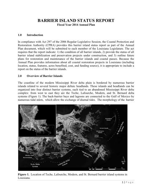
2.0 Overview of Barrier Isl<strong>and</strong>s<br />
The coastline of the modern Mississippi River delta plain is bordered by numerous <strong>barrier</strong><br />
<strong>isl<strong>and</strong></strong>s related to several historic major deltaic headl<strong>and</strong>s. These <strong>isl<strong>and</strong></strong>s <strong>and</strong> headl<strong>and</strong>s can be<br />
organized into four distinct <strong>barrier</strong> systems, each tied to an ab<strong>and</strong>oned Mississippi River delta<br />
complex: from west to east they are the Teche, Lafourche, Modern, <strong>and</strong> St. Bernard delta<br />
systems (Figure 1). The back-<strong>barrier</strong> bays <strong>and</strong> lagoons are connected to the Gulf of Mexico by<br />
numerous tidal inlets, which allow the exchange of diurnal tides. The morphology of the <strong>barrier</strong><br />
Figure 1. Location of Teche, Lafourche, Modern, <strong>and</strong> St. Bernard <strong>barrier</strong> <strong>isl<strong>and</strong></strong> systems in<br />
Louisiana.<br />
1 | P a g e
<strong>isl<strong>and</strong></strong>s along the Louisiana coast is related to the sediment supply <strong>and</strong> physical processes acting<br />
in the region (Georgiou et al., 2005). Because <strong>barrier</strong> <strong>isl<strong>and</strong></strong>s migrate <strong>and</strong> deteriorate over time<br />
(McBride <strong>and</strong> Byrnes, 1997), restoration of these habitats requires periodic addition of sediment<br />
to counteract the erosive forces. Numerous hurricanes <strong>and</strong> the Deepwater Horizon oil spill have<br />
clearly demonstrated the importance of having robust <strong>barrier</strong> <strong>isl<strong>and</strong></strong>s <strong>and</strong> a well-managed<br />
coastline in terms of shoreline resilience <strong>and</strong> hurricane damage reduction. These events have<br />
also highlighted the ecological concerns related to the massive loss of coastal wetl<strong>and</strong> <strong>and</strong> <strong>barrier</strong><br />
<strong>isl<strong>and</strong></strong> systems (Ewing <strong>and</strong> Pope, 2006). These coastal l<strong>and</strong>scapes can provide a significant <strong>and</strong><br />
potentially sustainable buffer from wind <strong>and</strong> wave action as well as storm surges generated by<br />
tropical storms <strong>and</strong> hurricanes. In addition, <strong>barrier</strong> shorelines are unique habitats that represent<br />
the foundation for complex <strong>and</strong> productive coastal ecosystems.<br />
The restoration of Louisiana‟s <strong>barrier</strong> <strong>isl<strong>and</strong></strong>s has been a priority for a number of programs over<br />
the past several decades. In the 1990‟s, <strong>barrier</strong> <strong>isl<strong>and</strong></strong> restoration was a priority for the <strong>Coastal</strong><br />
Wetl<strong>and</strong>s Planning, <strong>Protection</strong>, <strong>and</strong> <strong>Restoration</strong> Act (CWPPRA) program, which funded<br />
construction of a number of <strong>barrier</strong> <strong>isl<strong>and</strong></strong> restoration projects. More recently, the CPRA has<br />
constructed or is planning to construct a large number of additional projects (see below) to<br />
restore <strong>barrier</strong> <strong>isl<strong>and</strong></strong>s <strong>and</strong> headl<strong>and</strong>s in coastal Louisiana. The constructed projects have been<br />
studied <strong>and</strong> performance has been assessed to adaptively improve resilience <strong>and</strong> persistence of<br />
these projects.<br />
More than 20 <strong>barrier</strong> <strong>isl<strong>and</strong></strong> projects have been implemented in Louisiana over the past two<br />
decades. These projects are described below geographically from west to east, <strong>and</strong> are grouped<br />
by <strong>barrier</strong> <strong>isl<strong>and</strong></strong> system.<br />
2.1 Teche Delta System (Raccoon Isl<strong>and</strong> to Wine Isl<strong>and</strong>)<br />
2.1.1 Constructed Projects<br />
1. Raccoon Isl<strong>and</strong> Breakwaters Demonstration (TE-29; CWPPRA; 1997) – The goal of this<br />
project was to reduce shoreline erosion <strong>and</strong> increase l<strong>and</strong> coverage. Eight segmented<br />
breakwaters were constructed along the eastern end of the <strong>isl<strong>and</strong></strong> to reduce the rate of<br />
shoreline retreat, promote sediment deposition along the beach, <strong>and</strong> protect seabird habitat.<br />
Project effectiveness was determined by monitoring changes in the shoreline, wave energy,<br />
<strong>and</strong> elevations along the beach, <strong>and</strong> by surveys of the gulf floor between the shoreline <strong>and</strong><br />
the breakwaters.<br />
2. Whiskey Isl<strong>and</strong> <strong>Restoration</strong> (TE-27; CWPPRA; 1999) – The objective of this project was to<br />
create <strong>and</strong> restore beaches <strong>and</strong> back <strong>barrier</strong> marsh platform on Whiskey Isl<strong>and</strong>. Towards the<br />
Gulfside about 4.6 miles of the shoreline with beach/dune of variable width (700-800 feet)<br />
was restored using about 2.9 million cubic yards (MCY) of s<strong>and</strong>. The dune height was 4 feet<br />
with crest varying from 300-500 feet. The project consisted of creating 523 acres of back<br />
<strong>barrier</strong> marsh platform <strong>and</strong> filling in the breach at Coupe Nouvelle. The initial vegetation<br />
planting of smooth cordgrass (Spartina alterniflora) on the bayside shore was completed in<br />
July 1998 <strong>and</strong> additional vegetation seeding <strong>and</strong> planting was carried out in spring 2000.<br />
2 | P a g e
3. Whiskey Isl<strong>and</strong> Back Barrier Marsh Creation (TE-50; CWPPRA; 2009) – The goal of the<br />
TE-50 project was to increase the longevity of the previously restored <strong>and</strong> natural portions of<br />
the <strong>isl<strong>and</strong></strong> by increasing the <strong>isl<strong>and</strong></strong>‟s width which helped retain s<strong>and</strong> volume <strong>and</strong> elevation.<br />
Approximately 316 acres of back <strong>barrier</strong> intertidal marsh habitat, 5,800 linear feet of tidal<br />
creeks, three 1-acre tidal ponds <strong>and</strong> 13,000 linear feet of protective s<strong>and</strong> dune were created<br />
by semiconfined disposal <strong>and</strong> placement of dredged material. About 2.76 MCY of mixed<br />
sediment was dredged from an offshore borrow area in Gulf of Mexico near the <strong>isl<strong>and</strong></strong>. After<br />
removal of the mixed sediment overburden, about 0.36 MCY of underlying s<strong>and</strong> was used to<br />
create the dune fronting the marsh platform. The vegetative planting with native marsh<br />
vegetation to colonize <strong>and</strong> protect the newly-placed marsh soil was undertaken.<br />
4. Isles Dernieres <strong>Restoration</strong> Trinity Isl<strong>and</strong> (TE-24; CWPPRA; 1999) – The project objectives<br />
included the restoration of the dunes <strong>and</strong> back <strong>barrier</strong> marshes of Trinity Isl<strong>and</strong>.<br />
Approximately 4.85 MCY of s<strong>and</strong>/sediment were dredged from a borrow area in Lake Pelto<br />
to build approximately 4.3 miles long, 8 feet high dune with crest width of about 300 feet<br />
along with an elevated marsh platform at the bay side of the <strong>isl<strong>and</strong></strong>. A total of about 353 acres<br />
of supratidal <strong>and</strong> intratidal habitats were created. About 22,500 feet of s<strong>and</strong> fences were<br />
installed in various orientations along with vegetative planting to stabilize the s<strong>and</strong> <strong>and</strong><br />
minimize wind-driven transport.<br />
5. New Cut Dune <strong>and</strong> Marsh <strong>Restoration</strong> Project (TE-37; CWPPRA; 2007) - The purpose of<br />
this project was to close the breach between Trinity <strong>and</strong> East Isl<strong>and</strong>s through the creation of<br />
beach, dune, <strong>and</strong> marsh habitats in order to increase the structural integrity of eastern Isles<br />
Dernieres by restoring the littoral drift <strong>and</strong> adding sediment into the nearshore system. New<br />
Cut was closed through the construction of about 8,000 feet long dune platform (by placing<br />
approximately 0.85 MCY of s<strong>and</strong> dredge from an offshore borrow area) matching the dune<br />
elevations on the east <strong>and</strong> west, strengthening the connection between East <strong>and</strong> Trinity<br />
Isl<strong>and</strong>s. Nine species of native <strong>barrier</strong> <strong>isl<strong>and</strong></strong> vegetation were planted along with over 17,000<br />
linear feet of s<strong>and</strong> fence.<br />
6. Isles Dernieres <strong>Restoration</strong> East Isl<strong>and</strong> (TE-20; CWPPRA; 1999) – The project objective is<br />
to restore the coastal dunes <strong>and</strong> wetl<strong>and</strong>s of the Eastern Isles Dernieres. Approximately 3.9<br />
MCY of s<strong>and</strong> were dredged from Lake Pelto to build about 353 acres of beach <strong>and</strong> dune with<br />
target elevations of 2 feet <strong>and</strong> 8 feet, respectively. The dune crest width ranges from 300 to<br />
500 feet. S<strong>and</strong> fences <strong>and</strong> vegetation were also installed to stabilize the s<strong>and</strong> <strong>and</strong> minimize<br />
wind-driven transport.<br />
7. Enhancement of Barrier Isl<strong>and</strong> Vegetation Demonstration (TE-53; CWPPRA; 2010) – The<br />
goal of this project is to test several technologies or products to enhance the establishment<br />
<strong>and</strong> growth of key <strong>barrier</strong> <strong>isl<strong>and</strong></strong> <strong>and</strong> salt marsh vegetation. The project focuses specifically<br />
on enhancing the establishment <strong>and</strong> growth of transplants of both dune vegetation (Panicum<br />
amarum <strong>and</strong> Uniola paniculata) <strong>and</strong> marsh vegetation (Spartina alterniflora <strong>and</strong> Avicennia<br />
germinans). Planting took place on Whiskey Isl<strong>and</strong> <strong>and</strong> New Cut in 2010, <strong>and</strong> monitoring of<br />
vegetation began in 2011.<br />
3 | P a g e
2.1.2 Projects under Construction<br />
1. Raccoon Isl<strong>and</strong> Shoreline <strong>Protection</strong>/ Marsh Creation (TE-48; CWPPRA; 2007, 2013) – The<br />
goal of this project is to protect the Raccoon Isl<strong>and</strong> rookery <strong>and</strong> seabird colonies from an<br />
encroaching shoreline by reducing the rate of erosion along the western end of the <strong>isl<strong>and</strong></strong> <strong>and</strong><br />
creating more l<strong>and</strong> along the northern shoreline. This goal was accomplished through the<br />
construction of eight additional breakwaters west of the existing (TE-29) breakwaters <strong>and</strong> a<br />
terminal groin at the eastern of the <strong>isl<strong>and</strong></strong> (Phase A). In addition, mixed sediment from an<br />
offshore borrow site in Federal waters is being dredged to create 16 acres of back <strong>barrier</strong><br />
marsh platform with an average elevation of 3.5 feet (Phase B). The shoreline protection<br />
(Phase A) component of this project was constructed in 2007; construction of the marsh<br />
creation (Phase B) component is underway <strong>and</strong> expected to be completed in 2013.<br />
2.1.3 Future Projects<br />
1. NRDA Caillou Lake Headl<strong>and</strong>s <strong>Restoration</strong> Project (TE-100; NRDA): This project includes<br />
the project area as envisaged by previous CWPPRA project Ship Shoal: Whiskey West Flank<br />
<strong>Restoration</strong> (TE-47). The design template of this project is same as that suggested under the<br />
Louisiana <strong>Coastal</strong> Area (LCA) Terrebonne Basin Barrier Shoreline (TBBS) <strong>Restoration</strong><br />
Project, which includes the entire <strong>isl<strong>and</strong></strong> footprint. This project will provide a <strong>barrier</strong> to<br />
reduce wave <strong>and</strong> tidal energy, thereby protecting the mainl<strong>and</strong> shoreline from continued<br />
erosion. The objective of this project is to rebuild dunes <strong>and</strong> a marsh platform on the<br />
Whiskey Isl<strong>and</strong> through the emplacement of about 8.7 MCY of s<strong>and</strong> transported from Ship<br />
Shoal Block 88. About 4.26 miles of shoreline will be nourished with a 6.4 foot high <strong>and</strong> 220<br />
foot wide dune <strong>and</strong> 4.2 foot high <strong>and</strong> 464 foot wide beach covering around 497 acres. About<br />
0.972 MCY of sediment would be used to construct 198 acres of back <strong>barrier</strong> marsh<br />
platform. This project has been proposed for NRDA funding.<br />
2.2 Lafourche Delta System (Timbalier Isl<strong>and</strong> to Gr<strong>and</strong> Isle)<br />
2.2.1 Constructed Projects<br />
1. Timbalier Isl<strong>and</strong> Planting Demonstration (TE-18; CWPPRA; 1996) – For this project, s<strong>and</strong><br />
fences were installed <strong>and</strong> vegetation suited to the salinity <strong>and</strong> habitat type of Timbalier Isl<strong>and</strong><br />
was planted in several areas on the <strong>isl<strong>and</strong></strong> to trap s<strong>and</strong> <strong>and</strong> buffer wind <strong>and</strong> wave energy.<br />
2. Timbalier Isl<strong>and</strong> Dune <strong>and</strong> Marsh Creation (TE-40; CWPPRA; 2004) – Timbalier Isl<strong>and</strong> is<br />
migrating rapidly to the west/northwest; therefore, the western end of Timbalier Isl<strong>and</strong> is<br />
undergoing lateral migration by spit-building processes at the expense of erosion along the<br />
eastern end. The objective of this project was to restore the eastern end of Timbalier Isl<strong>and</strong><br />
by restoring beach, dunes, <strong>and</strong> marsh. An 8 foot high dune with average crest width of about<br />
400 feet was build using about 4.6 MCY of s<strong>and</strong>/sediment dredged from offshore borrow<br />
area which created a total fill area of about 273 acres, including about 196 acres of marsh<br />
platform.<br />
3. East Timbalier Isl<strong>and</strong> Sediment <strong>Restoration</strong>, Phase 1 (TE-25; CWPPRA; 2000) – The<br />
objective of this project was to strengthen <strong>and</strong> thus increase the longevity of East Timbalier<br />
4 | P a g e
Isl<strong>and</strong>. The project included the placement of dredged sediment in three embayments along<br />
the l<strong>and</strong>ward shoreline of East Timbalier Isl<strong>and</strong>, along with aerial seeding of the dune<br />
platform, installation of about 13,000 linear feet of s<strong>and</strong> fencing, <strong>and</strong> dune vegetation<br />
plantings. About 2.8 MCY of sediment was dredged from an offshore borrow area to create<br />
total of about 217 acres of supratidal <strong>and</strong> intratidal habitats which included a 5 foot high dune<br />
with crest width of about 200 feet <strong>and</strong> a 2 foot high <strong>and</strong> 500 foot wide marsh platform. This<br />
project was funded over two funding cycles, PPL 3 <strong>and</strong> 4, from 1999 <strong>and</strong> 2000, respectively.<br />
4. East Timbalier Isl<strong>and</strong> Sediment <strong>Restoration</strong>, Phase 2 (TE-30; CWPPRA; 2000) – The project<br />
goals <strong>and</strong> objectives were the same as that of Phase 1. While Phase 2 of the project along the<br />
western half of the <strong>isl<strong>and</strong></strong> did not reconnect the western <strong>and</strong> eastern portions of the <strong>isl<strong>and</strong></strong>, it<br />
did create 99% of the targeted acreage. It has helped to protect thous<strong>and</strong>s of acres of existing<br />
fringing marsh to the north. Construction funds from this phase of the project were also used<br />
for 7,000 feet of rubble mound revetment created to protect the newly created habitats.<br />
5. West Belle Pass Barrier Headl<strong>and</strong> <strong>Restoration</strong> (TE-52; CWPPRA; 2012) – The goals of this<br />
project were to re-establish the eroded West Belle Pass headl<strong>and</strong> via dune <strong>and</strong> marsh creation<br />
<strong>and</strong> to prevent increased erosion along the adjacent bay shoreline, protect the interior<br />
marshes <strong>and</strong> the Port Fourchon area. The project created a continuous headl<strong>and</strong><br />
approximately 10,660 feet in length, creating about 93 acres of dune habitat using nearly 1.74<br />
MCY of dredged s<strong>and</strong>, <strong>and</strong> about 227 acres of marsh habitat using 3.05 MCY of dredged<br />
mixed sediment. Construction began in May 2011 <strong>and</strong> completed in 2012.<br />
6. Bayside Segmented Breakwaters at Gr<strong>and</strong> Isle (BA-50; CIAP; 2012) – The purpose of this<br />
project was to reduce erosion on the bay side of Gr<strong>and</strong> Isle. Twenty-four 300 foot<br />
breakwaters (approximately 1.5 miles) were constructed on the back-bay side of Gr<strong>and</strong> Isle.<br />
This project was constructed with Jefferson Parish CIAP funds in September 2012.<br />
2.2.2 Projects under Construction<br />
1. Caminada Headl<strong>and</strong> Beach <strong>and</strong> Dune <strong>Restoration</strong> (BA-45; CIAP; Surplus) – The Caminada<br />
Headl<strong>and</strong> Beach <strong>and</strong> Dune <strong>Restoration</strong> project will restore <strong>and</strong> maintain the headl<strong>and</strong> through<br />
the creation of dunes <strong>and</strong> beach habitat <strong>and</strong> will protect unique coastal habitats, continue<br />
littoral s<strong>and</strong> transport to Gr<strong>and</strong> Isle, <strong>and</strong> protect Port Fourchon <strong>and</strong> the only hurricane<br />
evacuation route available to the region. This reach of the Barataria shoreline also supports<br />
the only l<strong>and</strong>-based access to the <strong>barrier</strong> shoreline in the Deltaic Plain. Portions of the<br />
Caminada Headl<strong>and</strong> component of the LCA Barataria Basin Barrier Shoreline (BBBS)<br />
<strong>Restoration</strong> Project template will begin construction in early 2013 using CIAP 2007 <strong>and</strong><br />
Surplus 2008 funds. Approximately 2.88 MCY of s<strong>and</strong> from South Pelto Blocks 12 &13<br />
borrow area (eastern portion of Ship Shoal Complex) will be placed to nourish approximately<br />
4.8 miles of shoreline by constructing a 7 foot high <strong>and</strong> about 290 foot wide dune <strong>and</strong> a 4.5<br />
foot high <strong>and</strong> 65 foot wide beach over a surface area of about 246 acres. This is the first time<br />
that s<strong>and</strong> from the Ship Shoal complex will be dredged for coastal restoration purposes.<br />
5 | P a g e
2.2.3 Future Projects<br />
1. NRDA Caminada Headl<strong>and</strong> Beach <strong>and</strong> Dune <strong>Restoration</strong> Increment 2 (BA-143, NRDA) –<br />
Project design for the proposed NRDA component of the Caminada Headl<strong>and</strong> Beach <strong>and</strong><br />
Dune <strong>Restoration</strong> Project is expected to be completed by early 2013. The design includes<br />
4.27 MCY of s<strong>and</strong> from the same borrow area in the South Pelto Block as BA-45 (above), to<br />
construct a 7 foot high dune with a 290 foot width along with a 4.5 foot high <strong>and</strong> 65 foot<br />
wide beach over a project length of 8.9 miles. It is expected to create a surface area of about<br />
532 acres.<br />
2.3 Modern Delta System (Chenier Ronquille to Scofield Isl<strong>and</strong>)<br />
2.3.1 Constructed Projects<br />
1. Vegetative Plantings of a Dredged Material Disposal Site on Gr<strong>and</strong> Terre Isl<strong>and</strong> (BA-28;<br />
CWPPRA; 2001) – The goal of this project is to stabilize dredged material sites on West<br />
Gr<strong>and</strong> Terre Isl<strong>and</strong>. This objective was achieved through vegetation plantings <strong>and</strong> by<br />
purchasing grazing rights on the <strong>isl<strong>and</strong></strong> for the 20-year life of the project.<br />
2. East Gr<strong>and</strong> Terre Isl<strong>and</strong> <strong>Restoration</strong> (BA-30; CIAP; 2010) – The goal of this project is to<br />
stabilize <strong>and</strong> benefit 1,575 acres of <strong>barrier</strong> <strong>isl<strong>and</strong></strong> habitat <strong>and</strong> extend the <strong>isl<strong>and</strong></strong>'s life<br />
expectancy by filling breaches <strong>and</strong> tidal inlets in the shoreline, <strong>and</strong> reinforce the existing<br />
shoreline with s<strong>and</strong>. For this about 621 acres of <strong>barrier</strong> <strong>isl<strong>and</strong></strong> were created by restoring 2.8<br />
miles of <strong>barrier</strong> shoreline through construction of a 6 foot high dune along with 165 acres of<br />
beach habitat <strong>and</strong> construction of about 456 acre marsh platform using about 3 MCY of s<strong>and</strong><br />
<strong>and</strong> 1.6 MCY of mixed sediment from two offshore borrow areas. Although CPRA<br />
constructed this projects using CIAP 2007 funds, this project was engineered, designed,<br />
permitted, <strong>and</strong> received the necessary l<strong>and</strong> rights for construction, through the CWPPRA<br />
program, in partnership with the NOAA Fisheries.<br />
3. Barataria Barrier Isl<strong>and</strong> Complex Project: Pelican Isl<strong>and</strong> <strong>and</strong> Pass La Mer to Chal<strong>and</strong> Pass<br />
<strong>Restoration</strong> (BA-38; CWPPRA; 2007, 2012) – The objectives of this project were to create<br />
<strong>barrier</strong> <strong>isl<strong>and</strong></strong> habitat, enhance storm-related surge <strong>and</strong> wave protection, prevent overtopping<br />
during storms, <strong>and</strong> increase the volume of s<strong>and</strong> within the active <strong>barrier</strong> system. This project<br />
includes restoration of two <strong>barrier</strong> <strong>isl<strong>and</strong></strong>s, viz. the Chal<strong>and</strong> Headl<strong>and</strong> portion of this project<br />
which was constructed in 2007 <strong>and</strong> construction of the Pelican Isl<strong>and</strong> segment which began<br />
in May 2011<strong>and</strong> completed in 2012. Additionally in June 2010, the State began construction<br />
of a <strong>barrier</strong> berm in response to the Deepwater Horizon oil spill from Shell Isl<strong>and</strong> to Scofield<br />
Isl<strong>and</strong> west of the river to safeguard its coast from the effects of the oil. The construction of<br />
the berm introduced a significant amount of s<strong>and</strong> into the <strong>barrier</strong> <strong>isl<strong>and</strong></strong> system.<br />
<br />
Pass La Mer to Chal<strong>and</strong> Pass <strong>Restoration</strong> (BA-38-1; CWPPRA; 2007) – A total<br />
fill area of 484 acres was created which included about 254 acres of back <strong>barrier</strong><br />
marsh platform with an average elevation of 2.5 feet. Marsh platform was<br />
constructed using about 1.0 MCY of overburden mixed sediment from an offshore<br />
borrow area. About 2.4 MCY of s<strong>and</strong> was placed to build about 230 acres of<br />
6 | P a g e
each-dune habitat with a dune height of 6 feet <strong>and</strong> crest width of 400 feet over a<br />
project length of 2.7 miles.<br />
<br />
Pelican Isl<strong>and</strong> <strong>Restoration</strong> Project (BA-38-2; CWPPRA; 2012) – Pelican Isl<strong>and</strong><br />
was restored using about 6.4 MCY of mixed sediment <strong>and</strong> s<strong>and</strong> from four<br />
different borrow areas in State <strong>and</strong> Federal waters ranging in distance from 2 to<br />
12 miles. About 2.1 MCY (in-place volume) of s<strong>and</strong> were utilized to create 192<br />
acres of beach-dune habitats. About 398 acres of marsh platform, with an average<br />
elevation of about 2.6 feet, was constructed using 1.6 MCY of sediment. Average<br />
dune elevation was about 7.5 feet extending to a length of 2.5 miles. It may be<br />
noted that Emergency Berm W9 was built in front of this <strong>isl<strong>and</strong></strong> using about 1.24<br />
MCY of s<strong>and</strong>.<br />
4. Pass Chal<strong>and</strong> to Gr<strong>and</strong> Bayou Pass Barrier Shoreline <strong>Restoration</strong> (BA-35; CWPPRA; 2009)<br />
– Also known as Bay Joe Wise, this project includes the emplacement of mixed sediment to<br />
create marsh along with tidal creeks <strong>and</strong> ponds, followed by vegetation plantings. The<br />
project's objectives are to: 1) prevent the breaching of the Bay Joe Wise shoreline by<br />
increasing <strong>barrier</strong> shoreline width; 2) increase back-<strong>barrier</strong>, emergent marsh area by<br />
approximately 220 acres to maintain the <strong>barrier</strong> shoreline; <strong>and</strong> 3) create emergent marsh<br />
suitable for tidal aquatic habitats. These features act as a buffer against wave <strong>and</strong> tidal<br />
energy, thereby protecting the mainl<strong>and</strong> shoreline from breaching <strong>and</strong> continued erosion.<br />
About 350 acres of total fill area was created which included a marsh platform approximately<br />
1,000 feet wide contiguous with the northern side of the gulf shoreline of Bay Joe Wise. The<br />
dune was built to an elevation of 6 feet with dune crest width of about 110 feet.<br />
Approximately 3 MCY of sediment was dredged from the Pas la Mer Ebb-Tide Delta, Pass<br />
Chal<strong>and</strong> Ebb-Tide Delta, <strong>and</strong> Gr<strong>and</strong> Pass Ebb-Tide Delta. The project also included the<br />
construction of approximately 10,000 feet of 4 foot wide, 2 foot deep tidal creeks or water<br />
exchange channels. In addition, immediate post-construction aerial seeding with Japanese<br />
millet (Echinochloa frumentacea) or brown top millet (Panicum ramosum) followed by<br />
smooth cordgrass (Spartina alterniflora) <strong>and</strong> black mangrove (Avicennia germinans)<br />
vegetative plantings were undertaken.<br />
5. Western Berm Reaches (West of Mississippi River along Shell, Pelican <strong>and</strong> Scofield Isl<strong>and</strong>s)<br />
In response to the Deepwater Horizon oil spill which began on April 20, 2010, the State of<br />
Louisiana constructed approximately 16 miles of s<strong>and</strong> berms along several sections of the<br />
State‟s <strong>barrier</strong> <strong>isl<strong>and</strong></strong>s both east <strong>and</strong> west of the Mississippi River. The objective of these<br />
projects was to provide a <strong>barrier</strong> to oil <strong>and</strong> minimize the potential impact of the oil spill to<br />
thous<strong>and</strong>s of acres of fragile <strong>barrier</strong> <strong>isl<strong>and</strong></strong>s <strong>and</strong> wetl<strong>and</strong>s in coastal Louisiana.<br />
a. Berm Reach W8 (Shell Isl<strong>and</strong>): The initial template of berm reach W8 was located within<br />
the footprint of the Shell Isl<strong>and</strong> restoration project which was proposed under the LCA<br />
BBBS project. However, pre-construction surveys indicated that the <strong>isl<strong>and</strong></strong> had receded,<br />
so the profile was shifted approximately 750 feet north. The construction template for<br />
the W8 berm reach was identical to the templates used on the other berm reaches: a 20<br />
foot crest width, +5 feet, NAVD88 crest elevation, 1V:25H side slopes above -2.0 feet,<br />
NAVD88 <strong>and</strong> 1V:50H below -2.0 feet, NAVD88. Construction of approximately 9,000<br />
7 | P a g e
linear feet of berm on Shell Isl<strong>and</strong> started on October 9, 2010 <strong>and</strong> was completed by<br />
November 23, 2010. Approximately 777,000 cubic yards of s<strong>and</strong> was placed along the<br />
<strong>isl<strong>and</strong></strong>.<br />
b. Berm Reach W9 (Pelican Isl<strong>and</strong>): Construction of berm reach W9 along Pelican Isl<strong>and</strong><br />
started on July 18, 2010 <strong>and</strong> was completed by October 2, 2010. S<strong>and</strong> was placed within<br />
the construction template, which was identical to the template used for the other berm<br />
reaches. The template was superimposed on the existing <strong>isl<strong>and</strong></strong> <strong>and</strong> within the footprint of<br />
the proposed <strong>Coastal</strong> Wetl<strong>and</strong>s Planning, <strong>Protection</strong>, <strong>and</strong> <strong>Restoration</strong> Act (CWPPRA)<br />
Pelican Isl<strong>and</strong> <strong>Restoration</strong> Project (BA-38-1). A total length of 12,700 feet of berm was<br />
constructed <strong>and</strong> approximately 1,294,000 cubic yards of s<strong>and</strong> was emplaced within the<br />
berm along Pelican Isl<strong>and</strong>.<br />
c. Berm Reach W10 (Scofield Isl<strong>and</strong>): Construction of berm reach W10 on Scofield Isl<strong>and</strong><br />
started on September 13, 2010. Approximately 935,000 cubic yards of s<strong>and</strong> was placed<br />
between September 13 <strong>and</strong> November 23, 2010 for constructing approximately 14,755<br />
feet of berm. The construction template for berm reach W10 was identical to the other<br />
berm reaches. The berm was constructed within the footprint of the proposed CWPPRA<br />
Scofield Isl<strong>and</strong> <strong>Restoration</strong> Project (BA-40).<br />
2.3.2 Projects under Construction<br />
1. Riverine S<strong>and</strong> Mining/Scofield Isl<strong>and</strong> <strong>Restoration</strong> (BA-40; Berm Funds; 2013) – The goals<br />
of this project are to mitigate breaches <strong>and</strong> tidal inlets in the shoreline, reinforce the existing<br />
shoreline with s<strong>and</strong>, increase the width of the <strong>isl<strong>and</strong></strong> with back <strong>barrier</strong> marsh to increase<br />
<strong>isl<strong>and</strong></strong> longevity, <strong>and</strong> re-establish a s<strong>and</strong>y dune along the length of the shoreline to protect the<br />
back <strong>barrier</strong> marsh platform from sea level rise <strong>and</strong> storm damage. The beach-dune habitats<br />
are constructed by the s<strong>and</strong> dredged from a borrow area in the Lower Mississippi River via<br />
22 mile long pipeline <strong>and</strong> the marsh platform from offshore borrow source of mixed<br />
sediment. Although this project was designed under CWPPRA, construction began in<br />
December 2012 using Berm to Barrier Funds. This will create approximately 11,400 foot<br />
long beach <strong>and</strong> dune fill to close the breach areas <strong>and</strong> restore/protect the erosive beach. The<br />
dune component includes a 50 foot wide crest width at +6 feet NAVD88. The beach fill<br />
template includes a 100 foot wide construction berm at +4 feet NAVD88. The surface area of<br />
the proposed beach platform is approximately 223 acres measured at +4 feet NAVD88. The<br />
required fill volume is approximately 2.03 MCY (required excavation volume is<br />
approximately 2.64 MCY). An approximately 11,800 foot long marsh platform on the bay<br />
side of Scofield Isl<strong>and</strong> was constructed. The surface area of the proposed marsh platform is<br />
approximately 375 acres with target marsh platform elevation of +3.0 feet NAVD88. The<br />
required fill volume is approximately 1.74 MCY (the required excavation volume is<br />
approximately 2.79 MCY). It may be noted that Emergency Berm W-10 was built in front of<br />
this <strong>isl<strong>and</strong></strong> using about 0.964 MCY of s<strong>and</strong>.<br />
2. Shell Isl<strong>and</strong> <strong>Restoration</strong> – Shell Isl<strong>and</strong> is a critical component of the Barataria shoreline<br />
which has been breached into two <strong>isl<strong>and</strong></strong>s – east <strong>and</strong> west. <strong>Restoration</strong> of these two <strong>isl<strong>and</strong></strong>s<br />
was initially included in LCA BBBS Project. The Shell Isl<strong>and</strong> <strong>Restoration</strong> project would<br />
8 | P a g e
estore this <strong>barrier</strong> <strong>isl<strong>and</strong></strong> through the creation of dune <strong>and</strong> marsh habitat. The overall goals of<br />
this project are to prevent intrusion of the Gulf of Mexico into interior bays <strong>and</strong> marshes,<br />
restore natural s<strong>and</strong> transport along this reach of the coast, <strong>and</strong> protect oil <strong>and</strong> gas facilities.<br />
This segment of the shoreline has been nearly lost. It may be noted that Emergency Berm<br />
Reach W8 was built using about 0.777 MCY of s<strong>and</strong> in front of the <strong>isl<strong>and</strong></strong>. This project has<br />
been split into two projects: Shell Isl<strong>and</strong> East-BERM (BA-110) <strong>and</strong> Shell Isl<strong>and</strong> West-<br />
NRDA (BA-111). Shell Isl<strong>and</strong> – East has been funded for construction, whereas Shell Isl<strong>and</strong><br />
– West is still to be funded.<br />
a. Shell Isl<strong>and</strong> East –BERM (BA-110) is funded by Berm to Barrier Funds. Shell Isl<strong>and</strong><br />
East is anticipated to commence construction during 2013. About 2.265 MCY of<br />
s<strong>and</strong> from Lower Mississippi River (same as Scofield <strong>Restoration</strong> Project (BA-40))<br />
will be used to construct an 8 foot high dune with a crest width of 340 feet along with<br />
a 5 foot high <strong>and</strong> 1,100 foot wide beach over a project length of about 5,380 feet<br />
creating a surface area of about 93 acres. About 83 acres of marsh platform will be<br />
constructed using about 0.278 MCY of mixed sediment from an offshore borrow<br />
source.<br />
2.3.3 Future Projects<br />
1. Shell Isl<strong>and</strong> West–NRDA (BA-111): This project is in design phase. The template of this<br />
project includes 15,750 feet of shoreline with an 8 foot high <strong>and</strong> 340 foot wide dune <strong>and</strong> a 5<br />
foot high <strong>and</strong> 1,100 foot wide beach, creating a surface area of about 277 acres with 7.6<br />
MCY of s<strong>and</strong>. About 308 acres of back <strong>barrier</strong> marsh platform will be constructed using<br />
about 2.1 MCY of mixed sediment. This project has been proposed for NRDA funding.<br />
2. Cheniere Ronquille Barrier Isl<strong>and</strong> <strong>Restoration</strong> (BA-76; CWPPRA) – This project would<br />
exp<strong>and</strong> the Cheniere Ronquille‟s gulf shoreline structural integrity by tying into two recently<br />
constructed projects to the east <strong>and</strong> address one of the remaining reaches of the Barataria/<br />
Plaquemines shoreline. The design includes fill for a beach <strong>and</strong> dune plus 20 years of<br />
advanced maintenance fill, as well as fill for marsh creation/nourishment. Approximately 127<br />
acres of beach/dune fill would be constructed <strong>and</strong> approximately 259 acres of back <strong>barrier</strong><br />
marsh platform would be constructed using the s<strong>and</strong>/sediment from the borrow areas<br />
identified for earlier projects. Once restored, this <strong>isl<strong>and</strong></strong> will provide critical habitat, <strong>and</strong> help<br />
reconnect the <strong>barrier</strong> <strong>isl<strong>and</strong></strong> chain that provides defense to inl<strong>and</strong> communities. Dune<br />
plantings would be conducted by seeding <strong>and</strong> installing approved nursery stock. About half<br />
of the marsh platform would be planted with cordgrass <strong>and</strong> portions of the dune, swale, <strong>and</strong><br />
marsh would be planted with appropriate woody species.<br />
3. Barataria Basin Barrier Shoreline (BBBS) <strong>Restoration</strong> (LA-10; LCA) – Initially this project<br />
included the Caminada Headl<strong>and</strong> Beach <strong>and</strong> Dune <strong>Restoration</strong> <strong>and</strong> Shell Isl<strong>and</strong> <strong>Restoration</strong><br />
Projects. Portions of Caminada Headl<strong>and</strong> are being constructed under CIAP <strong>and</strong> Surplus<br />
funds. The eastern beach/dune portion <strong>and</strong> marsh component are not currently funded for<br />
construction. Shell Isl<strong>and</strong> East is currently funded for construction with Berm to Barrier<br />
Funds, <strong>and</strong> Shell Isl<strong>and</strong> West has been proposed for NRDA funding. Construction of the<br />
remainder of the BBBS template features will be decided at a later date.<br />
9 | P a g e
2.4 St. Bernard Delta System<br />
2.4.1 Constructed Projects<br />
1. Ch<strong>and</strong>eleur Isl<strong>and</strong>s Marsh <strong>Restoration</strong> (PO-27; CWPPRA; 2001) – This project is intended to<br />
accelerate the recovery period of <strong>barrier</strong> <strong>isl<strong>and</strong></strong> areas overwashed by Hurricane Georges in<br />
1998 through vegetation plantings. The overwash areas, which encompass 364 acres, are<br />
located at 22 sites along the Ch<strong>and</strong>eleur Sound side of the <strong>isl<strong>and</strong></strong> chain <strong>and</strong> were planted with<br />
smooth cordgrass (Spartina alterniflora).<br />
2. Eastern Berm Reach E4 (East of Mississippi River along Ch<strong>and</strong>eleur Isl<strong>and</strong>s): In response to<br />
the Deepwater Horizon oil spill which began on April 20, 2010, the State of Louisiana<br />
constructed approximately 16 miles of s<strong>and</strong> berms along several sections of the State‟s<br />
<strong>barrier</strong> <strong>isl<strong>and</strong></strong>s both east <strong>and</strong> west of the Mississippi River. The objective of this project was<br />
to provide a <strong>barrier</strong> to oil <strong>and</strong> minimize the potential impact of the oil spill to thous<strong>and</strong>s of<br />
acres of fragile <strong>barrier</strong> <strong>isl<strong>and</strong></strong>s <strong>and</strong> wetl<strong>and</strong>s in coastal Louisiana. A total of 47,000 feet (8.9<br />
miles) of berm were constructed along the Ch<strong>and</strong>eleur Isl<strong>and</strong>s. It was estimated that a total<br />
of 5.85 MCY of s<strong>and</strong> was dredged from Hewes Point.<br />
2.4.2 Projects under Construction<br />
None<br />
2.4.3 Future Projects<br />
None<br />
3.0 Monitoring <strong>and</strong> Maintenance<br />
Louisiana‟s <strong>barrier</strong> <strong>isl<strong>and</strong></strong>s are part of a complex system controlled by many overlapping <strong>and</strong><br />
interrelated processes. The four primary <strong>barrier</strong> <strong>isl<strong>and</strong></strong> systems have been monitored <strong>and</strong><br />
evaluated by recent efforts, such as the Barrier Isl<strong>and</strong> Comprehensive Monitoring (BICM)<br />
program (Section 3.1) <strong>and</strong> the monitoring of the Emergency Berms (Section 3.2). In addition to<br />
the monitoring, the Barrier Isl<strong>and</strong> Maintenance Program (BIMP; Section 3.3) provides a<br />
framework for prioritizing planning, design, <strong>and</strong> construction of <strong>barrier</strong> <strong>isl<strong>and</strong></strong> maintenance<br />
projects when needs are identified. These programs have provided information to the CPRA<br />
regarding the current condition <strong>and</strong> stability of Louisiana‟s <strong>barrier</strong> <strong>isl<strong>and</strong></strong>s.<br />
3.1 Barrier Isl<strong>and</strong> Comprehensive Monitoring (BICM) program<br />
The development of a comprehensive program to evaluate the State‟s <strong>barrier</strong> shoreline was<br />
initiated by a Louisiana Department of Natural Resources (LDNR) workgroup (now headed by<br />
the CPRA) in 2002-03. This workgroup developed a monitoring framework to assess shoreline<br />
processes <strong>and</strong> resulting habitats, <strong>and</strong> the changes in these ecosystems over time. The initial plan<br />
was then reviewed in 2004 by the Louisiana Shoreline Science <strong>Restoration</strong> Team (SSRT)<br />
working under the LCA program. The LCA study recommended the establishment of a<br />
10 | P a g e
coordinated System-wide Assessment <strong>and</strong> Monitoring Program (SWAMP), which would<br />
integrate the environmental monitoring of wetl<strong>and</strong>s (Coastwide Reference Monitoring System,<br />
or CRMS-Wetl<strong>and</strong>s), rivers <strong>and</strong> inshore waters (CRMS-Waters), near-shore waters, <strong>and</strong> <strong>barrier</strong><br />
<strong>isl<strong>and</strong></strong>s (BICM). The initiation of the BICM program in 2005 was conducted through the CPRA<br />
<strong>and</strong> was funded by the LCA Science <strong>and</strong> Technology (S&T) office <strong>and</strong> through a partnership<br />
between the University of New Orleans (UNO) <strong>and</strong> the U.S. Geological Survey (USGS). Initial<br />
goals of the BICM program were to establish baseline conditions for the State‟s <strong>barrier</strong> shoreline<br />
after hurricanes Katrina <strong>and</strong> Rita, as well as to refine the methods <strong>and</strong> products for use in<br />
programs other than LCA (e.g., CWPPRA; CIAP; BIMP).<br />
The advantage of BICM over CWPPRA project-specific monitoring alone, is the ability to<br />
provide integrated long-term data on all of Louisiana‟s <strong>barrier</strong> shorelines, instead of just those<br />
areas with constructed projects. As a result, a greater amount of long-term data are now available<br />
to evaluate constructed projects, facilitate planning <strong>and</strong> design of future <strong>barrier</strong> <strong>isl<strong>and</strong></strong> projects,<br />
assist operations <strong>and</strong> maintenance activities, <strong>and</strong> determine storm impacts. Because data were<br />
collected for the entire <strong>barrier</strong> <strong>isl<strong>and</strong></strong> system concurrently, BICM data are more consistent <strong>and</strong><br />
complete than previous <strong>barrier</strong> <strong>isl<strong>and</strong></strong> data collection efforts.<br />
Initial BICM datasets collected include 1) post-storm damage assessment photography <strong>and</strong><br />
videography, 2) shoreline position, 3) l<strong>and</strong>/water analysis, 4) topography, 5) bathymetry, 6)<br />
habitat composition, <strong>and</strong> 7) surficial<br />
sediment composition. Additionally, these<br />
datasets have been compared to historic<br />
datasets, where available, that have been<br />
st<strong>and</strong>ardized therefore providing digital<br />
datasets to user groups for their use in<br />
multiple restoration efforts. Data collection<br />
for all seven BICM components initiated in<br />
2005 was completed in 2008. Final datasets<br />
<strong>and</strong> <strong>report</strong>s are currently available through<br />
the CPRA web site.<br />
Post-storm assessment products included<br />
an aerial video survey of the entire<br />
coastline <strong>and</strong> photographs of the majority<br />
of the shoreline. Photography of particular<br />
shoreline locations were then matched with<br />
historic photographs to provide time-series<br />
datasets for shoreline evaluations <strong>and</strong><br />
comparisons (Figure 2).<br />
These datasets have already proven<br />
invaluable in assessment of the impacts of<br />
Hurricanes Gustav <strong>and</strong> Ike in 2008, in the<br />
planning of LCA projects currently in the<br />
feasibility stage, <strong>and</strong> in the Deepwater<br />
Figure 2. Photo comparison of Elmer‟s Isl<strong>and</strong><br />
shoreline in Lafourche Parish, LA immediately<br />
after Hurricanes Katrina <strong>and</strong> Rita in 2005, <strong>and</strong><br />
approximately two years later.<br />
11 | P a g e
Horizon oil spill of 2010. These photos have also allowed assessment of impacts for<br />
documentation of damage claims to FEMA.<br />
A combination of CRMS-Wetl<strong>and</strong>s, UNO photography, <strong>and</strong> Quickbird satellite imagery was<br />
collected for the entire Louisiana coast. Shoreline positions using post-storm photography have<br />
been developed along with complete 1880s, 1930s, 1990s, <strong>and</strong> 2004 shorelines. The imagery has<br />
been analyzed, <strong>and</strong> datasets for historic, long-term, short-term, <strong>and</strong> near-term erosion rates for<br />
the entire coastline are available (Figure 3). Additionally, l<strong>and</strong>/water change maps <strong>and</strong> tables<br />
have been developed with the shoreline changes (Figures 4 <strong>and</strong> 5).<br />
Figure 3. Shoreline erosion rates for sections of the Louisiana coast. A) Historic (1850s-2005),<br />
B) Long-term (1920s–2005), C) Short-term (1996-2005), <strong>and</strong> D) Near-term (2004-2005)<br />
(Martinez et al., 2009 ).<br />
LiDAR data have been collected for all three portions of the s<strong>and</strong>y coast; the Ch<strong>and</strong>eleur Isl<strong>and</strong>s,<br />
from Raccoon Isl<strong>and</strong> to S<strong>and</strong>y Point, <strong>and</strong> the Chenier Plain from Sabine Pass to the Mermentau<br />
River Outlet. Data, grid models, <strong>and</strong> change models for all coastal areas are complete (Figure 6).<br />
USGS has continued to fly LiDAR for the Ch<strong>and</strong>eleur region <strong>and</strong> has provided an additional four<br />
surveys of the area (Figure 7). Additionally, LiDAR was flown by USGS for the Teche <strong>and</strong><br />
Lafourche Deltaic Regions in early 2008 <strong>and</strong> plans are underway to bring these data into the<br />
BICM program for use. Plans are also underway to fly LiDAR from Caminada Headl<strong>and</strong> to<br />
S<strong>and</strong>y Point in early 2013 as a part of a lower Barataria LiDAR update through a partnership<br />
with USGS.<br />
12 | P a g e
Figure 4. Historical overlays for the Isle Dernieres for 1887 – 2005. (Martinez et<br />
al., 2009).<br />
13 | P a g e
Figure 5. A time-series documenting the historical area changes in East Isl<strong>and</strong> (TE-<br />
20) between 1978 <strong>and</strong> 2005. Significant shoreline events are illustrated along the<br />
time-series line (Martinez et al., 2009).<br />
Figure 6. LiDAR topography of a portion of the Isle Derniers in Terrebonne parish<br />
in 2002 <strong>and</strong> 2006, as well as analysis of elevation changes within common areas of<br />
the data.<br />
14 | P a g e
Figure 7. Draft LiDAR surveys of a portion of the<br />
Northern Ch<strong>and</strong>eleur Isl<strong>and</strong>s. Colored portions are the<br />
l<strong>and</strong> areas above MHW.<br />
Bathymetric surveys were conducted during 2006 <strong>and</strong> 2007. The Chenier plain area <strong>and</strong> the<br />
southern Ch<strong>and</strong>eleur Isl<strong>and</strong>s were surveyed to complete the coast-wide coverage areas begun in<br />
2006. Surveys covered from five kilometers (km) offshore to two km bayward of the shoreline.<br />
In addition to bathymetry data, USGS collected sonar <strong>and</strong> seismic data along all the offshore<br />
lines <strong>and</strong> did a complete sidescan sonar mosaic of the gulf side of the Ch<strong>and</strong>eleur Isl<strong>and</strong>s. Data,<br />
grid models, <strong>and</strong> change models from all field work are finalized (Figures 8, 9, <strong>and</strong> 10).<br />
Figure 8. Example of chirp seismic–reflection profile data provided by USGS surveys of the<br />
Ch<strong>and</strong>eleur Isl<strong>and</strong>s. Data is available from Baldwin et al., 2009.<br />
15 | P a g e
Figure 9. Bathymetric maps for the Isle Dernieres - 1890s <strong>and</strong> 1930s.<br />
16 | P a g e
Figure 10. Bathymetric maps for the Isle Dernieres - 1980s <strong>and</strong> 2006.<br />
17 | P a g e
Habitat analysis based on the aerial photography is complete. Detailed habitat data for all BICM<br />
shoreline areas are available for 1996/98, 2002, 2004, <strong>and</strong> 2005 along with change maps<br />
showing habitat differences for all time periods (Figures 11 <strong>and</strong> 12).<br />
Collection of surficial sediments for sediment characterization was conducted in 2008 <strong>and</strong><br />
analysis is complete. Sediment characterization analysis, <strong>report</strong>s, <strong>and</strong> distribution maps are<br />
available (Figure 13).<br />
Analysis <strong>and</strong> final <strong>report</strong> preparation is ongoing through USGS <strong>and</strong> publication of an USGS<br />
open file <strong>report</strong> (Baldwin et al., 2009) should be completed in early 2013. Planning <strong>and</strong> design<br />
of the program will continue to refine future data collection, analysis, products, tools, <strong>and</strong><br />
timelines for future programmatic monitoring.<br />
CIAP funded monitoring of vegetation on some <strong>barrier</strong> <strong>isl<strong>and</strong></strong> projects will be used to refine<br />
vegetative sampling procedures proposed in the original 2003 BICM proposal document. These<br />
vegetative sampling procedures will be conducted <strong>and</strong> analyzed to determine the added value of<br />
vegetative sampling within the BICM program, <strong>and</strong> potential costs of full-scale implementation.<br />
Once this analysis is completed, decisions will be made whether to incorporate this additional<br />
BICM component as originally recommended.<br />
The next BICM Program data collection will be initiated in 2013 beginning with updated<br />
shoreline change <strong>and</strong> habitat analysis using the 2012 CRMS coastal photography recently<br />
collected. Work plans <strong>and</strong> contracts are currently being finalized to repeat other data collection<br />
activities along the coast over a four-year period, as well as exp<strong>and</strong> collection to areas not<br />
covered initially (Figure 14).<br />
3.2 Monitoring of the Emergency Berms<br />
In response to the Deepwater Horizon oil spill which began on April 20, 2010, the State of<br />
Louisiana constructed approximately 16 miles of s<strong>and</strong> berms along several sections of the State‟s<br />
<strong>barrier</strong> <strong>isl<strong>and</strong></strong>s both east <strong>and</strong> west of the Mississippi River. The objective of this project was to<br />
provide a <strong>barrier</strong> to oil <strong>and</strong> minimize the potential impact of the oil spill to thous<strong>and</strong>s of acres of<br />
fragile <strong>barrier</strong> <strong>isl<strong>and</strong></strong>s <strong>and</strong> wetl<strong>and</strong>s in coastal Louisiana. These berms are man-made features,<br />
were constructed for a specific purpose, as stated above, <strong>and</strong> are different geomorphologically<br />
than native <strong>barrier</strong> <strong>isl<strong>and</strong></strong>s. However, we gain significant insight into coastal processes which<br />
effect <strong>barrier</strong> <strong>isl<strong>and</strong></strong>s by monitoring their changes over time.<br />
On May 27, 2010, a NOD‐20 emergency permit (MVN 2010‐1066‐ETT) was issued by the U.S.<br />
Army Corps of Engineers (USACE), New Orleans District (CEMVN). The emergency permit<br />
allowed the construction of s<strong>and</strong> berms in specified areas or “reaches”. Specifically, reaches E3<br />
<strong>and</strong> E4 to the east of the Mississippi River, <strong>and</strong> reaches W8, W9, W10, <strong>and</strong> W11 to the west of<br />
the Mississippi River, were authorized for a total of approximately 38 miles of <strong>barrier</strong> berm.<br />
These areas were identified by USACE staff as critical locations where greater immediate benefit<br />
was likely to be achieved with minimal adverse disruption of the coastal environment. Only<br />
18 | P a g e
Figure 11. Habitat classification maps of East Isl<strong>and</strong> (TE-20), Isle Dernieres, Terrebonne<br />
Parish, LA for 1996 <strong>and</strong> 2002.<br />
19 | P a g e
Figure 12. Habitat classification maps of East Isl<strong>and</strong> (TE-20), Isle Dernieres, Terrebonne Parish,<br />
LA for 2004 <strong>and</strong> 2005.<br />
20 | P a g e
Figure 13. Surficial sediment characterization of the 2008 Isle Dernieres area in Terrebonne<br />
Parish, LA.<br />
Figure 14. Proposed BICM data collection structure for the 2013 through 2017 work effort.<br />
Note the additional areas of effort in the Eastern Chenier Plain <strong>and</strong> Teche Delta regions.<br />
21 | P a g e
eaches E4, W8, W9 <strong>and</strong> W10 (over 83,000 linear feet; approximately 16 miles of s<strong>and</strong> berm)<br />
were constructed under the NOD-20 emergency permit (Figures 15 <strong>and</strong> 16). Reaches W11 <strong>and</strong><br />
E3 were not constructed.<br />
Monitoring was required as a part of the emergency permit. Transects were established<br />
perpendicular to the shoreline, beginning at a point 1,000 feet l<strong>and</strong>ward from the inside toe of the<br />
berm <strong>and</strong> ending at the -20 foot NAVD88 isobath. The constructed berms were surveyed along<br />
these transects at five (5) time-intervals: after construction (as-built), <strong>and</strong> at 30, 90, 180 <strong>and</strong> 360-<br />
days post-construction to estimate s<strong>and</strong>-volume-changes (Table 1).<br />
Figure 15. Borrow Area <strong>and</strong> S<strong>and</strong> Berm (E4) locations on the eastern side of the<br />
Mississippi River. S<strong>and</strong> for E4 was mined from Hewes Point to the north <strong>and</strong> either<br />
placed directly into the berm, or transported to a reh<strong>and</strong>ling area (RH-2) using a hopper<br />
dredge (from borrow area HD-A). Borrow Area 6A was used as a temporary borrow site<br />
to begin work on the northernmost 2,000 linear feet of Reach E4 of the s<strong>and</strong> berm <strong>and</strong><br />
was backfilled with s<strong>and</strong> from Borrow Area CH-B.<br />
22 | P a g e
Figure 16. S<strong>and</strong> Berm (W8, W9 <strong>and</strong> W10) <strong>and</strong> Borrow Area locations on the<br />
western side of the Mississippi River. Reaches W8, W9, <strong>and</strong> W10 were constructed<br />
by dredging s<strong>and</strong> from approved borrow sites in Lower Mississippi River to preapproved<br />
reh<strong>and</strong>ling areas 35E <strong>and</strong> 25-5.<br />
Table 1. Summary of s<strong>and</strong> volumes from as-built <strong>and</strong> monitoring surveys for Emergency Berm<br />
reaches.<br />
Volumes (cy)<br />
Reach No. As-built<br />
30-day<br />
90-day<br />
180-day 360-day<br />
Monitoring Monitoring Monitoring Monitoring<br />
E4 3,166,600 3,117,400 3,857,400 3,493,000 2,451,700<br />
W8 777,300 722,600 685,100 625,100 642,600<br />
W9 1,242,500 1,194,000 979,800 1,004,300 977,500<br />
W10 964,200 817,100 863,900 931,800 875,200<br />
The monitoring data suggest that for berm reach E4, 77% of the fill had been retained at the 360-<br />
day monitoring survey; for berm reach W8, 83% of the fill had been retained at the 360-day<br />
monitoring survey; for berm reach W9, 79% of the total volume placed appears to be retained at<br />
360-days post-construction <strong>and</strong> for berm reach W10, approximately 91% of the volume placed in<br />
23 | P a g e
the berm had been retained at the 360-day monitoring survey. It should be noted that the direct<br />
causes of the changes in s<strong>and</strong> volumes discussed above are difficult to determine at this time.<br />
However, these changes are undoubtedly attributed to a combination of factors like longshore<br />
transport, overwash, settlement <strong>and</strong> subsidence that have all been experienced along Louisiana‟s<br />
<strong>barrier</strong> <strong>isl<strong>and</strong></strong> system.<br />
The data collected as part of the monitoring programs are extremely valuable to increase the<br />
underst<strong>and</strong>ing of coastal processes on Louisiana‟s <strong>barrier</strong> <strong>isl<strong>and</strong></strong>s. Data sets collected at such<br />
frequent intervals <strong>and</strong> relatively tight spacing are rare. The permit requires that surveys be<br />
conducted for 12 months following construction <strong>and</strong> that the volume of s<strong>and</strong> remaining within<br />
the berm reaches be calculated. The CPRA is developing additional analytical tools to further<br />
investigate processes responsible for sediment movement <strong>and</strong> sediment volume changes which<br />
affect the long-term resilience of the berms <strong>and</strong> of <strong>barrier</strong> shorelines in Louisiana.<br />
3.3 Barrier Isl<strong>and</strong> Maintenance Program (BIMP)<br />
Several legislative programs have been established on both the State <strong>and</strong> Federal levels that call<br />
for the implementation of a program to stabilize <strong>and</strong> preserve Louisiana‟s <strong>barrier</strong> <strong>isl<strong>and</strong></strong>s <strong>and</strong><br />
shorelines. House Bill No. 429, Act No. 407, authored by Representative Gordon Dove during<br />
the 2004 Regular Session, outlined the process by which the CPRA would annually develop a list<br />
of priority projects to be submitted to the House <strong>and</strong> Senate Committees on Natural Resources.<br />
These projects would be funded by the Barrier Isl<strong>and</strong> Stabilization <strong>and</strong> Preservation Fund, which<br />
was established by House Bill No. 1034, Act No. 786 of the 2004 Session to provide<br />
appropriations, donations, grants <strong>and</strong> other monies for the program. The legislation requires this<br />
fund to be used exclusively by the CPRA to support the Barrier Isl<strong>and</strong> Stabilization <strong>and</strong><br />
Preservation Program, with all interest earnings <strong>and</strong> unencumbered monies remaining in the fund<br />
at the end of the fiscal year.<br />
In accordance with this legislation, <strong>and</strong> with the underst<strong>and</strong>ing that maintenance is an integral<br />
part of stabilization, preservation, <strong>and</strong> restoration of any <strong>barrier</strong> <strong>isl<strong>and</strong></strong> or shoreline, BIMP was<br />
conceptualized by the CPRA. BIMP provides the framework for categorizing, prioritizing,<br />
selecting, <strong>and</strong> funding State <strong>barrier</strong> <strong>isl<strong>and</strong></strong> maintenance projects, while coordinating with<br />
CWPPRA <strong>and</strong> other existing restoration mechanisms.<br />
3.3.1 Rationale<br />
The BIMP program is necessary to quickly coordinate <strong>and</strong> fund the maintenance of previously<br />
constructed <strong>barrier</strong> shoreline restoration projects in Louisiana. This program can act as a<br />
comprehensive management approach to prioritizing rehabilitation efforts in coordination with<br />
other restoration initiatives (e.g., CWPPRA, LCA).<br />
During the past decade, numerous <strong>barrier</strong> <strong>isl<strong>and</strong></strong>s <strong>and</strong> headl<strong>and</strong>s in Louisiana have been or are<br />
currently being restored by the State <strong>and</strong> its Federal partners through CWPPRA <strong>and</strong> other<br />
sources. CWPPRA projects have a design life of 20 years; however, scheduled maintenance of<br />
these projects has not been incorporated into their funding or design. Design of these projects<br />
relies heavily on numerical models for predicting their longevity <strong>and</strong> ultimate success. Inherent<br />
24 | P a g e
in these models are certain assumptions <strong>and</strong> the realization that there are significant uncertainties<br />
about the physical processes that affect the stability of these l<strong>and</strong> masses. If the project is<br />
impacted by more events than assumed in the model, the condition of the <strong>barrier</strong> <strong>isl<strong>and</strong></strong> or<br />
headl<strong>and</strong> deteriorates considerably, thereby reducing the life of the project. The project then<br />
requires maintenance to sustain the predicted design template. Maintenance costs can increase<br />
exponentially when not performed in a timely manner. Therefore, BIMP is a tool that can be<br />
used to formulate a much needed component of maintenance planning for existing projects<br />
without maintenance funds. This strategy will address the need for timely <strong>and</strong> cost-effective<br />
maintenance of <strong>barrier</strong> shoreline projects to ensure their long-term success.<br />
3.3.2 Program Area<br />
BIMP encompasses all <strong>barrier</strong> <strong>isl<strong>and</strong></strong>s, headl<strong>and</strong>s, <strong>and</strong> s<strong>and</strong>y shorelines, restored or otherwise<br />
(Figure 17). Based on the geographic <strong>and</strong> geologic setting, the domain of the BIMP program<br />
includes the eight coastal segments identified below (Campbell et al. 2005).<br />
1. Ch<strong>and</strong>eleur Isl<strong>and</strong>s – Northern Ch<strong>and</strong>eleur Isl<strong>and</strong>s (Freemason Isl<strong>and</strong>s, North Isl<strong>and</strong>s, <strong>and</strong><br />
New Harbor Isl<strong>and</strong>s) <strong>and</strong> Southern Ch<strong>and</strong>eleur Isl<strong>and</strong>s (Breton Isl<strong>and</strong>, Gr<strong>and</strong> Gosier Isl<strong>and</strong>,<br />
<strong>and</strong> Curlew Isl<strong>and</strong>s).<br />
2. Plaquemines – S<strong>and</strong>y Point, Pelican Isl<strong>and</strong>, Shell Isl<strong>and</strong>, „„Chal<strong>and</strong> Headl<strong>and</strong>‟‟ (Pass La Mer<br />
area), Chenier Ronquille, <strong>and</strong> East <strong>and</strong> West Gr<strong>and</strong> Terre Isl<strong>and</strong>s.<br />
3. Lafourche – Gr<strong>and</strong> Isle <strong>and</strong> Caminada- Moreau Headl<strong>and</strong>.<br />
4. Timbalier Isl<strong>and</strong>s – Timbalier <strong>and</strong> East Timbalier Isl<strong>and</strong>s.<br />
5. Isle Dernieres – Raccoon, Whiskey, Trinity, East, <strong>and</strong> Wine Isl<strong>and</strong>s.<br />
6. Freshwater Bayou to Point Au Fer – Point Au Fer, Marsh Isl<strong>and</strong>, <strong>and</strong> Chenier au Tigre.<br />
7. Eastern Chenier Plain – Freshwater Bayou to Calcasieu Pass.<br />
8. Western Chenier Plain – Calcasieu Pass to Sabine Pass.<br />
Grouping these apparently disparate <strong>and</strong> disjointed units of <strong>barrier</strong> <strong>isl<strong>and</strong></strong>s, headl<strong>and</strong>s, <strong>and</strong> s<strong>and</strong>y<br />
shorelines into coastal segments will facilitate the development of a regional long-term strategy<br />
for shoreline maintenance, including project prioritization <strong>and</strong> development. It should be noted<br />
that any alteration to an area within a segment will affect the remainder of the segment due to<br />
coastal processes <strong>and</strong> morphodynamics, <strong>and</strong>, consequently, the sediment budget.<br />
3.3.3 Funding <strong>and</strong> Timeline<br />
As part of BIMP, the CPRA will formulate an annual list of potential projects based on<br />
inspections of previously constructed projects, post-storm assessments, BICM data, <strong>and</strong> existing<br />
project maintenance schedules. Data from these sources will be used to identify existing projects<br />
with an immediate need for repairs. All projects will be compiled <strong>and</strong> ranked by December 1 of<br />
each year. This list, along with recommended funding levels, will be provided to both the House<br />
<strong>and</strong> Senate Committees on Natural Resources for approval <strong>and</strong> funding. Funding will come from<br />
the Barrier Isl<strong>and</strong> Stabilization <strong>and</strong> Preservation Fund as set forth in House Bill No. 1034, Act<br />
No. 786 of the 2004 Session.<br />
25 | P a g e
Figure 17. Various coastal segments including s<strong>and</strong>y shorelines, headl<strong>and</strong>s, <strong>and</strong> <strong>barrier</strong> <strong>isl<strong>and</strong></strong>s.<br />
3.3.4 BIMP Projects<br />
1. The 2006/2007 BIMP projects approved for implementation were the Bay Champagne Marsh<br />
Creation <strong>and</strong> Bay Champagne S<strong>and</strong> Fencing projects. Bay Champagne is a 250-acre body of<br />
water just east of Port Fourchon in Lafourche Parish. Currently, only a narrow dune feature<br />
separates the bay from the Gulf, <strong>and</strong> a breach of this dune would expose interior marsh to<br />
increased erosion. These restoration projects would create 70 acres of marsh in the bay, as<br />
well as utilize s<strong>and</strong> fencing to stabilize the fore <strong>and</strong> back dune areas. The total combined<br />
cost of the projects was estimated at $2,820,000. These projects were discontinued due to a<br />
lack of sediment sources in close proximity. Additionally, the Caminada Headl<strong>and</strong> project<br />
currently funded for construction should address the Bay Champagne area-of-need when it is<br />
constructed.<br />
2. The 2007/2008 BIMP selections were the Sediment Bypassing at the Mermentau Jetties <strong>and</strong><br />
the East Gr<strong>and</strong> Terre Vegetative Plantings projects. The former project planned to add<br />
$1,387,688 in Cameron Parish CIAP funds with $2,750,000 in BIMP funds to hydraulically<br />
dredge sediment adjacent to the east Mermentau Jetty <strong>and</strong> move it to the west side. This<br />
would allow the littoral drift to disperse the sediment on the beach front. The goal of this<br />
project was to rebuild approximately 75 to 100 acres of gulf shoreline at Hackberry Beach.<br />
However, this project was deemed unfeasible because a preliminary investigation found there<br />
was insufficient s<strong>and</strong> to justify this project, <strong>and</strong> preliminary modeling showed that removing<br />
sediment adjacent to the east jetty could cause accelerated erosion <strong>and</strong> possible breaching of<br />
the shoreline at the north end of the jetty. The East Gr<strong>and</strong> Terre Vegetative Plantings project<br />
26 | P a g e
will be implemented in the project area of the East Gr<strong>and</strong> Terre Isl<strong>and</strong> <strong>Restoration</strong> (BA-30)<br />
CIAP project that was constructed in 2010. The total cost of the BIMP planting project is<br />
approximately $750,000.<br />
3. The BIMP project approved for implementation in the 2008/2009 cycle was the 2009 S<strong>and</strong><br />
Fencing Project, which consisted of installation of 34,000 linear feet of s<strong>and</strong> fencing within<br />
the project areas of five constructed <strong>barrier</strong> <strong>isl<strong>and</strong></strong> restoration projects in Terrebonne <strong>and</strong><br />
Plaquemines Parishes. The construction contract amount was $198,200. The proposed s<strong>and</strong><br />
fencing was installed on Trinity/East Isl<strong>and</strong>s in the eastern Isles Dernieres (TE-20 East<br />
Isl<strong>and</strong>, TE-24 Trinity Isl<strong>and</strong>, <strong>and</strong> TE-37 New Cut project areas); Timbalier Isl<strong>and</strong> (TE-40<br />
Timbalier Isl<strong>and</strong> project area); <strong>and</strong> near Chal<strong>and</strong> Pass (BA-38 Chal<strong>and</strong> Headl<strong>and</strong> project<br />
area). Installation of the s<strong>and</strong> fencing will facilitate the capturing of wind-blown s<strong>and</strong> <strong>and</strong><br />
building of additional s<strong>and</strong> dunes on the <strong>isl<strong>and</strong></strong>s. The work was completed in May 2010. No<br />
additional projects were selected this cycle, as the Sediment Bypassing at the Mermentau<br />
Jetties <strong>and</strong> East Gr<strong>and</strong> Terre Vegetative Plantings projects were expected to use funds from<br />
this funding cycle.<br />
4. No new BIMP projects were selected in the 2009/2010 cycle, because the Mermentau Jetties<br />
project‟s preliminary feasibility investigations continued through early 2010, <strong>and</strong> it was<br />
expected that the Jetties project would use funding from this cycle. When this project was<br />
deemed unfeasible, it was hoped that another suitable project could be developed within<br />
Cameron Parish, so the funds from this BIMP funding cycle were set aside for this potential<br />
new project. However, another suitable project was not identified for this funding cycle in<br />
Cameron Parish.<br />
4.0 Barrier Isl<strong>and</strong> Performance Assessment<br />
4.1 Overall Barrier Shoreline Condition<br />
Louisiana‟s <strong>barrier</strong> shoreline is one of the fastest eroding shorelines in the world. Due to the<br />
geologic setting <strong>and</strong> the predicted changes in sea level during coming decades, these shoreline<br />
habitats <strong>and</strong> the services they provide are some of the most vulnerable features of our coastal<br />
l<strong>and</strong>scape. The CPRA‟s BICM Program has been established to assess <strong>and</strong> <strong>report</strong> on the changes<br />
of the coastal shoreline to help develop programmatic approaches to restoration <strong>and</strong><br />
maintenance. In addition, CPRA funded an interim study (CEC, 2012) to look at <strong>barrier</strong> <strong>isl<strong>and</strong></strong><br />
performance in the five years since BICM data were collected.<br />
Current shoreline erosion data from BICM (Martinez et al., 2009) indicate that most of<br />
Louisiana‟s shoreline is eroding faster than ever before, with some short-term (1996 – 2005)<br />
erosion rates more than double the historic (1890s – 2005) averages (Figures 18 <strong>and</strong> 19).<br />
However, recent information from the post-BICM studies elucidate the benefits of recent<br />
restoration projects. This section presents the overall findings from BICM; a more detailed<br />
discussion by geomorphologic delta complex follows. The shoreline change characterizations<br />
found below are estimates based on available information <strong>and</strong> are not necessarily indicative of<br />
future changes.<br />
27 | P a g e
ft/yr<br />
Isle Derniers<br />
Timbalier<br />
Isl<strong>and</strong><br />
East<br />
Timbalier<br />
Isl<strong>and</strong><br />
Caminada-<br />
Moreau<br />
Headl<strong>and</strong><br />
Gr<strong>and</strong> Isle<br />
Plaquemines<br />
South<br />
Ch<strong>and</strong>eleur<br />
Isl<strong>and</strong>s<br />
North<br />
Ch<strong>and</strong>eleur<br />
Isl<strong>and</strong>s<br />
ft/yr<br />
WEST CHENIER<br />
PLAIN<br />
EAST CHENIER<br />
PLAIN<br />
ACADIANA BAYS<br />
TECHE DELTA<br />
LAFOURCHE<br />
DELTA<br />
MODERN DELTA<br />
CHANDELEUR<br />
ISLANDS<br />
PONTCHARTRAIN<br />
BASIN<br />
The Ch<strong>and</strong>eleur Isl<strong>and</strong>s have exhibited the largest changes in erosion rates. Historic erosion<br />
rates of approximately 27 ft/yr have increased within the past decade to more than 125 ft/yr,<br />
BICM Shoreline Change Rates<br />
40.0<br />
20.0<br />
0.0<br />
-20.0<br />
-40.0<br />
-60.0<br />
-80.0<br />
-100.0<br />
-120.0<br />
-140.0<br />
BICM REGION<br />
Historic Change Long-Term Change Short-Term Change<br />
Figure 18. Average shoreline erosion rates for BICM Regions of the Louisiana Coast developed<br />
from aerial photography for Historic (1890‟s – 2005), Long-term (1930‟s – 2005), <strong>and</strong> Shortterm<br />
(1996 – 2005) periods.<br />
BICM Shoreline Change Rates<br />
100.0<br />
0.0<br />
-100.0<br />
-200.0<br />
-300.0<br />
-400.0<br />
-500.0<br />
-600.0<br />
-700.0<br />
-800.0<br />
c<br />
McBride & Byrnes 1997 Divisions<br />
Historic Change Long-Term Change Short-Term Change Near-Term Change<br />
Figure 19. Average shoreline erosion rates for various sections of the Louisiana coast including<br />
the direct impacts of Hurricanes Katrina <strong>and</strong> Rita (Near-Term 2004- 2005). Note that the<br />
Timbalier Isl<strong>and</strong> shoreline accreted due to the 2004/05 CWPPRA restoration project (TE-40)<br />
(McBride <strong>and</strong> Byrnes 1997 4 ).<br />
28 | P a g e
predominantly due to storm activities. This has led to a decrease in the overall size of Breton<br />
Isl<strong>and</strong> by approximately 776 acres, or 95% (Table 2). Additionally, over 66% (85.1 acres) of the<br />
l<strong>and</strong> area remaining in 2004 was removed by Hurricanes Katrina <strong>and</strong> Rita in 2005. When<br />
compared to the fact that only 18 percent (150.7 acres) of the l<strong>and</strong> mass was lost between 1850<br />
<strong>and</strong> 1920, this emphasizes the need to maintain the <strong>isl<strong>and</strong></strong>s so that they are more sustainable<br />
during storm events. The data seem to indicate that there is a “tipping point” when an <strong>isl<strong>and</strong></strong><br />
breaches, beyond which erosion accelerates, restoration costs increase exponentially <strong>and</strong> results<br />
may become less predictable.<br />
Table 2. Historical (1800‟s-2005), long term (1930‟s-2005), <strong>and</strong> short term (1996-2005) <strong>barrier</strong><br />
<strong>isl<strong>and</strong></strong> changes in acres <strong>and</strong> the projected date of disappearance (Martinez et al., 2009).<br />
Isl<strong>and</strong> 1800s 1922-30s 1996-98 2004 2005<br />
Projected<br />
Year of<br />
Disappearance<br />
Breton 820.4 669.7 212.3 128.7 43.6 2013<br />
Ch<strong>and</strong>eleur 6,827.50 6,140.60 4,333.10 2,789.60 913.9 2026<br />
Gr<strong>and</strong> Gossier/Curlew 1,119.40 71.7 595.5 75.2 0<br />
New Harbor 177.9 232.3 85.7 76.9 87 2135<br />
North 1,455.50 966.2 125.8 77.1 79.7 2013<br />
Freemason 538.7 247.1 28.8 17.6 4.8 2006<br />
Isle Derniers 8,727.80 4,838.30 1,566.50 1,613.90 1,595.50 2033<br />
Timbalier 3,669.50 2,646.50 1,147.40 1,028.40 1,069.40 2056<br />
East Timbalier 476.9 229.8 311.7 311.4 245.3 2138<br />
Gr<strong>and</strong> Isle 2,616.80 2,347.50 2,439.50 2,232.00 2,286.00 2867<br />
Gr<strong>and</strong> Terre 4,198.30 2,614.40 1,093.40 1,021.10 997.7 2044<br />
Shell Isl<strong>and</strong> 313.8 432.4 89.7 56.5 51 2029<br />
The large reduction of Breton Isl<strong>and</strong> within the last decade, along with the extreme loss<br />
experienced from Hurricane Katrina, emphasizes the need to maintain flexibility in setting<br />
restoration priorities. McBride <strong>and</strong> Byrnes (1997) predicted that Breton Isl<strong>and</strong> would disappear<br />
in 2106 based on the l<strong>and</strong> loss rates through the 1980s. When compared to other <strong>isl<strong>and</strong></strong>s that<br />
were projected to be lost in the early 2000s, the restoration of Breton Isl<strong>and</strong> was a comparatively<br />
low priority. However, based on BICM data collected after Hurricanes Katrina <strong>and</strong> Rita, the<br />
projected disappearance for Breton Isl<strong>and</strong> based on the l<strong>and</strong> loss rates through 2005 (does not<br />
include impacts from Hurricanes Gustav <strong>and</strong> Ike in 2008 or Hurricane Isaac in 2012) is now<br />
2013 (Table 2). More dramatic than Breton Isl<strong>and</strong> are Gr<strong>and</strong> Gossier <strong>and</strong> Curlew Isl<strong>and</strong>s, which<br />
were predicted by McBride <strong>and</strong> Byrnes (1997) to last until 2174, yet these <strong>isl<strong>and</strong></strong>s were both<br />
reduced to shoals by Hurricane Katrina in 2005.<br />
The good news is that restoration efforts on other <strong>isl<strong>and</strong></strong>s have shown benefits. McBride <strong>and</strong><br />
Byrnes (1997) predicted Timbalier Isl<strong>and</strong> would disappear by 2046, based on data through the<br />
1980s. However, restoration completed just prior to Hurricanes Katrina <strong>and</strong> Rita added<br />
29 | P a g e
approximately 10 years of life to the <strong>isl<strong>and</strong></strong>. Also, McBride <strong>and</strong> Byrnes (1997) predicted that the<br />
Isles Dernieres would disappear by 2017; however, the CWPPRA <strong>barrier</strong> <strong>isl<strong>and</strong></strong> restoration<br />
projects constructed on the <strong>isl<strong>and</strong></strong>s have increased their life span by approximately 16 years.<br />
Nonetheless, additional storms, increasing erosion rates, <strong>and</strong> predicted sea-level rise still need to<br />
be taken into account for designing future projects.<br />
The Deepwater Horizon oil spill presented an entirely new challenge to coastal Louisiana. The<br />
State responded with a robust effort to safeguard its coast from the effects of the oil. In June<br />
2010, the State began construction of <strong>barrier</strong> berms along the Ch<strong>and</strong>eleur Isl<strong>and</strong>s east of the<br />
Mississippi River (East Barrier Berm) <strong>and</strong> from Shell Isl<strong>and</strong> to Scofield Isl<strong>and</strong> west of the river<br />
(West Barrier Berms). The construction of the Barrier Berm projects introduced a significant<br />
amount of s<strong>and</strong> into the State‟s <strong>barrier</strong> <strong>isl<strong>and</strong></strong> systems. To maximize this opportunity, the State is<br />
utilizing the berm s<strong>and</strong> <strong>and</strong> approximately $100 million of the funds set aside for berm<br />
construction to convert the temporary berm features into the more resilient <strong>barrier</strong> <strong>isl<strong>and</strong></strong> features<br />
that were designed as CWPPRA projects. The CWPPRA Scofield project (BA-40) is being<br />
constructed using Berm to Barrier funds. Shell Isl<strong>and</strong> East (BA-110) will be constructed by<br />
Berm to Barrier funds.<br />
Additional datasets <strong>and</strong> analysis, ongoing under BICM, are also beginning to show information<br />
which will hopefully increase our ability to forecast priority areas <strong>and</strong> better predict project<br />
outcome. Until final <strong>report</strong>s are concluded for all sections of the coast, the main indications are<br />
that:<br />
1. <strong>Coastal</strong> shoreline erosion rates are increasing (Figures 18 <strong>and</strong> 19). Along the central coast<br />
<strong>barrier</strong>s, interior wetl<strong>and</strong> loss results in increasing tidal prism (volume of water that flows<br />
through the inlet during each tidal cycle) (Figure 20). Central coast s<strong>and</strong> is sequestered in<br />
exp<strong>and</strong>ing ebb tidal deltas as inlets widen <strong>and</strong> deepen <strong>and</strong> these processes occur at the<br />
expense of <strong>barrier</strong> <strong>isl<strong>and</strong></strong> s<strong>and</strong> volume. This sequestering of s<strong>and</strong> volume offshore has<br />
dominated over relative sea level rise in reducing <strong>isl<strong>and</strong></strong> area.<br />
2. Hurricane impacts <strong>and</strong> subsequent recovery processes dominate Ch<strong>and</strong>eleur Isl<strong>and</strong>s<br />
evolution, whereby s<strong>and</strong> is removed from the central portion of the <strong>isl<strong>and</strong></strong> <strong>and</strong> distributed<br />
laterally, ultimately coming to rest in deepwater sinks at the flanks of the <strong>barrier</strong> <strong>isl<strong>and</strong></strong> arc<br />
(Figure 21). This better underst<strong>and</strong>ing of the sediment transport pathways <strong>and</strong> scales allows<br />
efficient <strong>barrier</strong> <strong>isl<strong>and</strong></strong> management strategies to be developed.<br />
3. Seafloor change analysis results show that long-term sediment transport trends are about two<br />
orders of magnitude greater than calculated predictions of longshore sediment transport<br />
potential in the nearshore zone based on historical wave data (millions of cubic meters per<br />
year instead of tens of thous<strong>and</strong>s) (Figure 22).<br />
4. The identification <strong>and</strong> quantification of these sediment transport processes, pathways, <strong>and</strong><br />
sinks is crucial for successful sediment budget management <strong>and</strong> sediment allocation <strong>and</strong><br />
project prioritization.<br />
30 | P a g e
Figure 20. Combined tidal inlet cross-sectional area for Raccoon Point to S<strong>and</strong>y Point<br />
for each time period covered by the study (1880–2006). Profiles trend along the <strong>barrier</strong><br />
shoreline <strong>and</strong> intersect inlets at the location of minimum throat cross-sectional area for<br />
each time period. Note the widening <strong>and</strong> deepening at existing inlets as additional, stable<br />
inlets simultaneously form, resulting in a more than threefold increase in combined<br />
cross-sectional area during the past 125 years in response to an increasing tidal prism<br />
associated with interior marshl<strong>and</strong> loss. The 1880s to 1980s bathymetry is from List et<br />
al. (1994) (from Miner et al., 2009).<br />
4.2 Teche Delta Barrier Isl<strong>and</strong>s (Raccoon Isl<strong>and</strong> to Wine Isl<strong>and</strong>)<br />
The Teche Delta Barrier Isl<strong>and</strong>s (Isles Dernieres) benefitted from the first <strong>barrier</strong> <strong>isl<strong>and</strong></strong><br />
restoration projects funded through the CWPPRA program (Figure 23 <strong>and</strong> Table 3). In total, six<br />
projects have been constructed in this region.<br />
According to the BICM data presented above through 2005, the Teche Delta <strong>barrier</strong> <strong>isl<strong>and</strong></strong>s were<br />
projected to disappear by 2033. A more recent study including post-BICM data <strong>report</strong>s<br />
disappearance date by <strong>isl<strong>and</strong></strong> <strong>and</strong> suggests that restoration projects may have extended the life<br />
expectancy of these <strong>isl<strong>and</strong></strong>s.<br />
4.2.1 Raccoon Isl<strong>and</strong><br />
The l<strong>and</strong> area over time for Raccoon Isl<strong>and</strong> is plotted in Figure 24. It is noted that Raccoon<br />
Isl<strong>and</strong> underwent emergency restoration in 1994, which may have contributed to the upward<br />
trend between 1990 <strong>and</strong> 1998. Although no sediment was placed on the <strong>isl<strong>and</strong></strong>, it has benefitted<br />
from two CWPPRA projects, TE-29 <strong>and</strong> TE-48A, which included installing breakwaters, first in<br />
31 | P a g e
Figure 21. 1870s to 2006-07 seafloor change from Breton Isl<strong>and</strong> to Hewes Point. Note the<br />
large magnitude of erosion on the center shoreface as well as the large deposition zones at each<br />
terminal end of the arc. (UNO/PIES)<br />
Figure 22. 1880s to 2005 seafloor change from Raccoon Point to S<strong>and</strong>y Point. Note the<br />
large magnitude of erosion fronting the Caminada Headl<strong>and</strong> <strong>and</strong> the Plaquemines <strong>barrier</strong><br />
shoreline, as well as the deposition at ebb-tidal deltas in the coastal bights at Cat Isl<strong>and</strong> Pass <strong>and</strong><br />
the Barataria Inlets. The map coordinate system is UTM Zone 15 N meters. The 1880s<br />
bathymetry is from List et al. (1994). Shoreline data are from Martinez et al. (2009). (Miner et<br />
al., 2009).<br />
32 | P a g e
Figure 23. Location of <strong>barrier</strong> <strong>isl<strong>and</strong></strong> restoration projects in Teche Delta Barrier System. (CEC,<br />
2012).<br />
Table 3. List of projects constructed, funded for construction, <strong>and</strong> for future implementation in<br />
the Teche Delta Barrier System.<br />
Funding<br />
Program<br />
Construction<br />
Date<br />
Barrier Shoreline <strong>Restoration</strong> Projects<br />
Teche Barrier System<br />
Constructed Projects<br />
Raccoon Isl<strong>and</strong> Breakwaters (TE-29) CWPPRA 1997<br />
Whiskey Isl<strong>and</strong> <strong>Restoration</strong> (TE-27) CWPPRA 1999<br />
Whiskey Isl<strong>and</strong> Back Barrier Marsh Creation (TE-50) CWPPRA 2009<br />
Isles Dernieres <strong>Restoration</strong> Trinity Isl<strong>and</strong> (TE-24) CWPPRA 1999<br />
New Cut Dune <strong>and</strong> Marsh <strong>Restoration</strong> (TE-37) CWPPRA 2007<br />
Isles Dernieres <strong>Restoration</strong> East Isl<strong>and</strong> (TE-20) CWPPRA 1999<br />
Funded for Construction<br />
Raccoon Isl<strong>and</strong> Shoreline <strong>Protection</strong>/ Marsh Creation (TE-48) (under constr.) CWPPRA 2013<br />
Future Projects<br />
NRDA (proposed) Caillou Lake Headl<strong>and</strong>s (TE-100) (in design)<br />
(includes Ship Shoal: Whiskey West Flank <strong>Restoration</strong> (TE-47))<br />
33 | P a g e
Figure 24. Raccoon Isl<strong>and</strong> L<strong>and</strong> Area Change Analysis (CEC, 2012).<br />
1997 <strong>and</strong> again in 2005. These breakwaters re-oriented the wave climate/energy regime in such<br />
a way that s<strong>and</strong> from an adjacent, nearshore shoal was redistributed as inverted salients between<br />
the breakwaters <strong>and</strong> the <strong>isl<strong>and</strong></strong>. The pre-breakwater Year of Disappearance (YOD) was projected<br />
to be 2000. Hurricanes Katrina <strong>and</strong> Rita caused significant l<strong>and</strong> loss on Raccoon Isl<strong>and</strong> in 2005<br />
(Martinez et al., 2006), however post-breakwater installation, the YOD was projected to be 2017.<br />
The benefits of <strong>barrier</strong> shoreline restoration are evidenced by the post-breakwater increase in<br />
<strong>isl<strong>and</strong></strong> longevity, projected to be 17 years, compared to the pre-breakwater projected rate of<br />
disappearance.<br />
4.2.2 Whiskey Isl<strong>and</strong><br />
The l<strong>and</strong> area over time for Whiskey Isl<strong>and</strong> is plotted in Figure 25. The <strong>isl<strong>and</strong></strong> benefitted from<br />
two CWPPRA restoration projects, the first, TE-27, in 1999 <strong>and</strong> the second, TE-50, in 2009.<br />
The pre-restoration YOD was projected to be 2091. Post-restoration, the YOD was projected to<br />
be 2130. It is noted that Hurricanes Katrina <strong>and</strong> Rita caused significant l<strong>and</strong> loss on Whiskey<br />
Isl<strong>and</strong> in 2005 (Martinez et al., 2006), reducing its acreage below the trend line. The benefits of<br />
<strong>barrier</strong> shoreline restoration are evidenced by the post-restoration increase in <strong>isl<strong>and</strong></strong> longevity,<br />
projected to be 39 years, compared to the pre-restoration projected rate of disappearance.<br />
4.2.3 Trinity-East Isl<strong>and</strong><br />
The l<strong>and</strong> area over time for Trinity-East Isl<strong>and</strong> is plotted in Figure 26. It is noted that East Isl<strong>and</strong><br />
was the site of a pilot study project in 1985, <strong>and</strong> received a breach repair project in 1996 which<br />
may have contributed to the upward trend between 1990 <strong>and</strong> 1998. The <strong>isl<strong>and</strong></strong>s benefitted from<br />
34 | P a g e
Figure 25. Whiskey Isl<strong>and</strong> L<strong>and</strong> Area Change Analysis (CEC, 2012).<br />
Figure 26. Trinity-East Isl<strong>and</strong> L<strong>and</strong> Area Change Analysis (CEC, 2012)<br />
CWPPRA restoration projects TE-20 <strong>and</strong> TE-24 in 1999, <strong>and</strong> TE-37 in 2007. The prerestoration<br />
YOD was projected to be 2052. Post-restoration, the YOD was projected to be 2053.<br />
It is noted that Hurricanes Katrina, Rita, Gustav, <strong>and</strong> Ike caused significant l<strong>and</strong> loss on Trinity-<br />
East Isl<strong>and</strong> between 2005 <strong>and</strong> 2008 (Doran et al., 2009; Martinez et al., 2006). As such, it is<br />
expected that the l<strong>and</strong> loss rate would have accelerated, <strong>and</strong> in absence of the 1999 restoration<br />
project, Trinity-East Isl<strong>and</strong> would have disappeared significantly sooner than the 2052<br />
projection.<br />
35 | P a g e
4.3 Lafourche Delta Barrier Isl<strong>and</strong>s (Timbalier Isl<strong>and</strong> to Gr<strong>and</strong> Isle)<br />
The Lafourche Delta Barrier Isl<strong>and</strong>s have benefitted from a number of <strong>barrier</strong> <strong>isl<strong>and</strong></strong> restoration<br />
projects, most recently the East Gr<strong>and</strong> Terre Isl<strong>and</strong> <strong>Restoration</strong> project (BA-30) that was<br />
completed through CIAP (Figure 27 <strong>and</strong> Table 4). In total, five projects have been constructed<br />
in this region <strong>and</strong> several others are planned.<br />
Figure 27. Location of <strong>barrier</strong> <strong>isl<strong>and</strong></strong> restoration projects in Lafourche Delta Barrier System<br />
(CEC, 2012).<br />
Table 4. List of projects constructed, funded for construction, <strong>and</strong> for future implementation in<br />
the Lafourche Delta Barrier System.<br />
Funding<br />
Program<br />
Construction<br />
Date<br />
Barrier Shoreline <strong>Restoration</strong> Projects<br />
Lafourche Barrier System<br />
Constructed Projects<br />
Timbalier Isl<strong>and</strong> Planting Demonstration (TE-18) CWPPRA 1996<br />
Timbalier Isl<strong>and</strong> Dune <strong>and</strong> Marsh Creation (TE-40) CWPPRA 2004<br />
East Timbalier Isl<strong>and</strong> Sediment <strong>Restoration</strong>, Phase 1 (TE-25) CWPPRA 2000<br />
East Timbalier Isl<strong>and</strong> Sediment <strong>Restoration</strong>, Phase 2 (TE-30) CWPPRA 2000<br />
West Belle Pass Barrier Headl<strong>and</strong> <strong>Restoration</strong> (TE-52) CWPPRA 2012<br />
Bayside Segmented Breakwaters at Gr<strong>and</strong> Isle (BA-50) CIAP 2012<br />
Funded for Construction<br />
Caminada Headl<strong>and</strong> Beach <strong>and</strong> Dune <strong>Restoration</strong> (BA-45) (under construction)<br />
Future Projects<br />
Barataria Basin Barrier Shoreline (BBBS) <strong>Restoration</strong> (BA-10)<br />
Eastern portion of Caminada<br />
NRDA (proposed) Caminada Headl<strong>and</strong> Beach <strong>and</strong> Dune <strong>Restoration</strong>, increment 2<br />
(BA-143) (under design)<br />
CIAP/<br />
Surplus 2014<br />
LCA<br />
36 | P a g e
According to the BICM data through 2005, the projected YODs for these <strong>isl<strong>and</strong></strong>s are 2056<br />
(Timbalier), 2138 (East Timbalier), 2867 (Gr<strong>and</strong> Isle), <strong>and</strong> 2044 (Gr<strong>and</strong> Terre). A more recent<br />
study including post-BICM data <strong>report</strong>s disappearance date by <strong>isl<strong>and</strong></strong> <strong>and</strong> suggests much sooner<br />
rates of disappearance for Timbalier (2044) <strong>and</strong> East Timbalier (2018) <strong>isl<strong>and</strong></strong>s.<br />
4.3.1 Timbalier Isl<strong>and</strong><br />
The l<strong>and</strong> area over time for Timbalier Isl<strong>and</strong> is plotted in Figure 28. It is noted that Timbalier<br />
Isl<strong>and</strong> was the site of a breach repair project in 1996 which may have contributed to the upward<br />
trend in l<strong>and</strong> area between 1990 <strong>and</strong> 1998. The <strong>isl<strong>and</strong></strong> was restored through CWPPRA project<br />
TE-40 in 2004. The pre-restoration YOD was projected to be 2043. Post-restoration, the YOD<br />
was projected to be 2044. It is noted that Hurricanes Katrina, Rita, Gustav, <strong>and</strong> Ike caused<br />
significant l<strong>and</strong> loss on Timbalier Isl<strong>and</strong> between 2005 <strong>and</strong> 2008 (Rodrigue et al., 2011;<br />
Martinez et al., 2006). As such, it is expected that the l<strong>and</strong> loss rate would have accelerated, <strong>and</strong><br />
in absence of the 2004 restoration project, Timbalier Isl<strong>and</strong> would have disappeared significantly<br />
sooner than the 2043 projection.<br />
Figure 28. Timbalier Isl<strong>and</strong> L<strong>and</strong> Area Change Analysis (CEC, 2012)<br />
4.3.2 East Timbalier Isl<strong>and</strong><br />
The l<strong>and</strong> area over time for East Timbalier Isl<strong>and</strong> is plotted in Figure 29. The <strong>isl<strong>and</strong></strong> was<br />
restored through CWPPRA projects TE-25 <strong>and</strong> TE-30 in 2000. The pre-restoration YOD was<br />
projected to be 2014. Post-restoration, the YOD was projected to be 2018. It is noted that<br />
Hurricanes Katrina, Rita, Gustav, <strong>and</strong> Ike caused significant l<strong>and</strong> loss on East Timbalier Isl<strong>and</strong><br />
between 2005 <strong>and</strong> 2008 (Doran et al., 2009; Martinez et al., 2006). As such, it is expected that<br />
the l<strong>and</strong> loss rate would have accelerated, <strong>and</strong> in absence of the 2000 restoration projects, East<br />
Timbalier Isl<strong>and</strong> would have disappeared significantly sooner than the 2014 projection.<br />
37 | P a g e
Figure 29. East Timbalier Isl<strong>and</strong> L<strong>and</strong> Area Change Analysis (CEC, 2012)<br />
4.4 Modern Delta Barrier Isl<strong>and</strong>s (Chenier Ronquille to Scofield Isl<strong>and</strong>)<br />
The Modern Delta Barrier Isl<strong>and</strong>s have benefitted from a number of very recent <strong>barrier</strong> <strong>isl<strong>and</strong></strong><br />
restoration projects, in addition to the Barrier Berms that were constructed as a part of the BP oil<br />
spill response (Figure 30 <strong>and</strong> Table 5).<br />
Although BICM did not <strong>report</strong> estimated disappearance rates for all of these <strong>isl<strong>and</strong></strong>s, the BICM<br />
data presented above through 2005 projected that Shell Isl<strong>and</strong> would have disappeared by 2029<br />
(Table 2; Section 5.1). Recent assessment of shoreline erosion rates for the Modern Delta <strong>barrier</strong><br />
<strong>isl<strong>and</strong></strong>s suggest that the recent projects constructed by CPRA have prograded the shoreline<br />
positions gulfward relative to their pre- hurricanes Katrina <strong>and</strong> Rita positions (Figure 31).<br />
Pre-restoration average rates of shoreline erosion ranged from -4.5 ft/yr (Pelican Isl<strong>and</strong>) to -41.7<br />
ft/yr (East Gr<strong>and</strong> Terre Isl<strong>and</strong>). Post-restoration rates of shoreline erosion range from +12.7 ft/yr<br />
(Pelican Isl<strong>and</strong>) to +85.9 ft/yr (East Gr<strong>and</strong> Terre Isl<strong>and</strong>) noting the higher value for East Gr<strong>and</strong><br />
Terre Isl<strong>and</strong> may be related to the fact the project was recently completed in 2010 <strong>and</strong> the<br />
analysis utilized the post-construction survey. For this same time period, the average erosion<br />
rate for Chenier Ronquille was -46.1 ft/yr. It is noted that the post-restoration period included<br />
the s<strong>and</strong> berms on Pelican <strong>and</strong> Scofield Isl<strong>and</strong>s, neither of which underwent full <strong>isl<strong>and</strong></strong><br />
restoration during this time period. These reversals of shoreline change rates, from erosion to<br />
accretion, are evidence that the restoration projects have benefited not only the individual<br />
<strong>isl<strong>and</strong></strong>s, but the system as a whole.<br />
38 | P a g e
Figure 30. Location of <strong>barrier</strong> <strong>isl<strong>and</strong></strong> restoration projects in Lafourche Delta Barrier System<br />
(CEC, 2012).<br />
Table 5. List of projects constructed, funded for construction, <strong>and</strong> for future implementation in<br />
the Modern Delta Barrier System.<br />
Barrier Shoreline <strong>Restoration</strong> Projects<br />
Modern Barrier System<br />
Constructed Projects<br />
Funding<br />
Program<br />
Construction<br />
Date<br />
East Gr<strong>and</strong> Terre Isl<strong>and</strong> <strong>Restoration</strong> (BA-30) CIAP 2010<br />
Pass La Mer to Chal<strong>and</strong> Pass (BA-38-1)<br />
also known as "Chal<strong>and</strong> Headl<strong>and</strong>" CWPPRA 2006<br />
Pass Chal<strong>and</strong> to Gr<strong>and</strong> Bayou Pass Barrier Shoreline <strong>Restoration</strong> (BA-35)<br />
also known as "Bay Joe Wise" CWPPRA 2009<br />
Barataria Barrier Isl<strong>and</strong> Complex Project: Pelican Isl<strong>and</strong> <strong>and</strong> Pass (BA-38-2) CWPPRA 2012<br />
Emergency Berms W8, W9, W10<br />
Berm<br />
Funds 2010-2011<br />
Funded for Construction<br />
Berm<br />
Shell Isl<strong>and</strong> <strong>Restoration</strong> "Berm" (under construction)<br />
Riverine S<strong>and</strong> Mining/Scofield Isl<strong>and</strong> <strong>Restoration</strong> (BA-40)<br />
Future Projects<br />
Chenier Ronquille Barrier Isl<strong>and</strong> <strong>Restoration</strong> (BA-76)<br />
NRDA (proposed) Shell Isl<strong>and</strong> <strong>Restoration</strong> (under design)<br />
Funds 2013<br />
CWPPRA/<br />
Berm<br />
Funds 2013<br />
39 | P a g e
Figure 31. Barrier <strong>isl<strong>and</strong></strong> average gulf-side shoreline change rates pre-restoration (1884-2005)<br />
<strong>and</strong> post-restoration (2005-2010/2011). Projects constructed (<strong>and</strong> years) are also listed in the<br />
data table.<br />
4.4.1 East Gr<strong>and</strong> Terre<br />
East Gr<strong>and</strong>e Terre Isl<strong>and</strong> is part of the original Gr<strong>and</strong> Terre Isl<strong>and</strong> which has divided into East<br />
<strong>and</strong> West Gr<strong>and</strong> Terre Isl<strong>and</strong>s separated by Pass Abel. This <strong>isl<strong>and</strong></strong> was restored in 2010 through<br />
the construction of the East Gr<strong>and</strong> Terre Isl<strong>and</strong> <strong>Restoration</strong> Project (BA-30) by the CPRA with<br />
funding from the <strong>Coastal</strong> Impact Assistance Program (CPE, 2011). The East Gr<strong>and</strong> Terre Isl<strong>and</strong><br />
<strong>Restoration</strong> Project was part of the original East <strong>and</strong> West Gr<strong>and</strong> Terre Isl<strong>and</strong> <strong>Restoration</strong> Project<br />
which was cooperatively designed <strong>and</strong> engineered by the CPRA <strong>and</strong> National Marine Fisheries<br />
Service through the CWPPRA program.<br />
Presented in Figure 32 are the average shoreline change rates for East Gr<strong>and</strong> Terre. The prerestoration<br />
erosion rates ranged from -38.9 ft/yr (BICM short-term) to -48.3 ft/yr (BICM longterm)<br />
noting the BICM historical average was on the same order of magnitude equal to -41.7<br />
ft/yr. East Gr<strong>and</strong> Terre has experienced breaching throughout the long-term <strong>and</strong> short-term<br />
intervals. The <strong>isl<strong>and</strong></strong> experienced net accretion in the near-term interval (+85.9 ft/yr on average)<br />
noting this period included the recently completed restoration project. The new historical<br />
average, equal to -34.7 ft/yr, is less than the BICM time period averages. Thus restoration of the<br />
<strong>isl<strong>and</strong></strong>‟s geomorphic form <strong>and</strong> function offset a significant percentage of the erosion experienced<br />
in the short-term period, returning the historical erosion rate to less than pre-restoration rates.<br />
40 | P a g e
Figure 32. East Gr<strong>and</strong> Terre Average Shoreline Change Rates (CEC, 2012).<br />
4.4.2 Chenier Ronquille<br />
Presented in Figure 33 are the average<br />
shoreline change rates for Chenier<br />
Ronquille. In general the erosion rates<br />
have accelerated over time, ranging from<br />
-30.5 ft/yr (BICM historical) to -46.1 ft/yr<br />
(near-term). Shell Isl<strong>and</strong> experienced<br />
multiple breaches between 2004 <strong>and</strong> 2006<br />
attributed to Hurricanes Katrina <strong>and</strong> Rita.<br />
Chenier Ronquille has not been restored<br />
to date, but future restoration projects are<br />
planned (BA-76). The new historical<br />
erosion rate average, equal to -30.7 ft/yr,<br />
is nearly identical to the BICM historical<br />
rate.<br />
Figure 33. Chenier Ronquille Average Shoreline<br />
Change Rates (CEC, 2012).<br />
41 | P a g e
4.4.3 Chal<strong>and</strong> Headl<strong>and</strong><br />
The Chal<strong>and</strong> Headl<strong>and</strong> extends from Pass Chal<strong>and</strong> (now closed) on its eastern end to Pass La<br />
Mer on its western end. This headl<strong>and</strong> was restored in 2006 under CWPPRA Project BA-38-2<br />
(CPE, 2008). Presented in Figure 34 are the average shoreline change rates for the Chal<strong>and</strong><br />
Headl<strong>and</strong>. The pre-restoration erosion rates ranged from -17.4 ft/yr (BICM long-term) to -32.6<br />
ft/yr (BICM short-term), noting the short-term average was over 1.5 times the long-term average<br />
<strong>and</strong> the BICM historical average equal to -19.0 ft/yr. The Chal<strong>and</strong> Headl<strong>and</strong> first breached<br />
between 1998 <strong>and</strong> 2004 <strong>and</strong> experienced additional breaching in 2005 attributed to Hurricanes<br />
Katrina <strong>and</strong> Rita, all of which occurred<br />
during the short-term interval. This<br />
breaching correlates to the amplified<br />
shoreline erosion rate. The <strong>isl<strong>and</strong></strong><br />
experienced net shoreline progradation in<br />
the near-term interval (+41.3 ft/yr on<br />
average), noting this period included the<br />
restoration project. The new historical<br />
average shoreline erosion equaled -16.4<br />
ft/yr, which was on the same order of<br />
magnitude as the BICM historical <strong>and</strong><br />
long-term averages. Thus restoration of<br />
the <strong>isl<strong>and</strong></strong>‟s geomorphic form <strong>and</strong> function<br />
offset a significant percentage of the<br />
erosion experienced in the short-term<br />
period, returning the historical erosion rate<br />
to pre-restoration rates.<br />
4.4.4 Bay Joe Wise<br />
Figure 34. Chal<strong>and</strong> Headl<strong>and</strong> Average Shoreline<br />
Change Rates (CEC, 2012).<br />
This <strong>barrier</strong> shoreline extends from Gr<strong>and</strong><br />
Bayou Pass (now closed) on its eastern end to<br />
Pass Chal<strong>and</strong> on its western end. This<br />
headl<strong>and</strong> was restored in 2008-2009 under<br />
CWPPRA Project BA-35 (CEC, 2010)<br />
entitled Pass Chal<strong>and</strong> to Gr<strong>and</strong> Bayou Pass<br />
Barrier Shoreline <strong>Restoration</strong>. Presented in<br />
Figure 35 are the average shoreline change<br />
rates for the Bay Joe Wise Headl<strong>and</strong>. The<br />
pre-restoration erosion rates ranged from -5.0<br />
ft/yr (BICM long-term) to -27.1 ft/yr (BICM<br />
short-term) noting the short-term average was<br />
over 5 times the long-term average <strong>and</strong> over 3<br />
times the BICM historical average equal to -<br />
7.8 ft/yr. Bay Joe Wise first breached<br />
between 1998 <strong>and</strong> 2004 <strong>and</strong> experienced<br />
additional breaching in 2005 attributed to<br />
Figure 35. Bay Joe Wise Average Shoreline<br />
Change Rates (CEC, 2012).<br />
42 | P a g e
Hurricanes Katrina <strong>and</strong> Rita, all of which occurred during the short-term interval. This<br />
breaching correlates to the amplified shoreline erosion rate. The <strong>isl<strong>and</strong></strong> experienced net accretion<br />
in the near-term interval (+34.6 ft/yr on average), noting this period included the restoration<br />
project. The new historical average equaled -5.5 ft/yr, which was on the same order of<br />
magnitude as the BICM historical <strong>and</strong> long-term averages. Thus restoration of the <strong>isl<strong>and</strong></strong>‟s<br />
geomorphic form <strong>and</strong> function offset a significant percentage of the erosion experienced in the<br />
short-term period, returning the historical erosion rate to pre-restoration rates.<br />
4.4.5 Shell Isl<strong>and</strong><br />
Presented in Figure 36 are the average shoreline change rates for Shell Isl<strong>and</strong>. The erosion rates<br />
ranged from -74.9 ft/yr (BICM historical) to -355.6 ft/yr (BICM short-term) noting the shortterm<br />
average was over 4.5 times the historical average <strong>and</strong> over 3.5 times the BICM long-term<br />
average of -94.8 ft/yr. Shell Isl<strong>and</strong> first breached between 1884 <strong>and</strong> 1922 <strong>and</strong> continued to<br />
divide into multiple <strong>isl<strong>and</strong></strong>s as it disintegrated over time. Shell Isl<strong>and</strong>‟s high erosion rate is in<br />
part attributed to the Empire Waterway jetties, which interrupt the natural alongshore transport<br />
from east to west.<br />
The initial template of Barrier Berm reach W8 was located within the footprint of the Shell<br />
Isl<strong>and</strong> restoration project which was proposed under the LCA BBBS project. However, preconstruction<br />
surveys indicated that the <strong>isl<strong>and</strong></strong> had receded, so the profile was shifted<br />
approximately 750 feet north (l<strong>and</strong>ward).<br />
The construction template for the W8 berm<br />
reach was identical to the templates used<br />
on the other berm reaches: a 20-foot crest<br />
width, +5 feet, NAVD88 crest elevation,<br />
1V:25H side slopes above -2.0 feet,<br />
NAVD88 <strong>and</strong> 1V:50H below -2.0 feet,<br />
NAVD88. Construction of approximately<br />
9,000 linear feet of berm on Shell Isl<strong>and</strong><br />
started on October 9, 2010 <strong>and</strong> was<br />
completed by November 23, 2010.<br />
Approximately 790,000 cubic yards of<br />
s<strong>and</strong> was placed along the <strong>isl<strong>and</strong></strong>.<br />
Monitoring of emergency s<strong>and</strong> berm reach<br />
W8 indicates that 83% of the material had<br />
been retained after the first 360-day<br />
monitoring event.<br />
Figure 36. Shell Isl<strong>and</strong> Average Shoreline Change<br />
Rates (prior to Emergency Berm construction;<br />
CEC, 2012).<br />
4.4.6 Pelican Isl<strong>and</strong><br />
Presented in Figure 37 are the average shoreline change rates for Pelican Isl<strong>and</strong>. It is noted this<br />
<strong>isl<strong>and</strong></strong> benefitted by Barrier Berm W9 (Thompson, 2012). The pre-berm erosion rates ranged<br />
from -4.5 ft/yr (BICM historical) to -40.5 ft/yr (BICM short-term) noting the short-term average<br />
was 9 times the historical average <strong>and</strong> over 2.5 times the BICM long-term average equal to -16.2<br />
43 | P a g e
ft/yr. Pelican Isl<strong>and</strong> first breached between 1998 <strong>and</strong> 2004, which occurred during the shortterm<br />
interval. This breaching correlates to the amplified shoreline erosion rate. The <strong>isl<strong>and</strong></strong><br />
experienced net shoreline progradation in the near-term interval (+12.7 ft/yr on average) noting<br />
this period included the s<strong>and</strong> berm construction. The new historical average equaled -3.8 ft/yr,<br />
which was on the same order of magnitude as the BICM historical average. Thus placement of<br />
the s<strong>and</strong> berm restored some of the <strong>isl<strong>and</strong></strong>‟s geomorphic form <strong>and</strong> function, returning the<br />
historical erosion rate to pre-breach rates.<br />
Construction of Barrier Berm reach W9<br />
along Pelican Isl<strong>and</strong> started on July 18,<br />
2010 <strong>and</strong> was completed by October 2,<br />
2010. S<strong>and</strong> was transported from reh<strong>and</strong>ling<br />
area 35-E <strong>and</strong> emplaced within<br />
the construction template, which was<br />
identical to the template used for the other<br />
berm reaches. The template was<br />
superimposed on the existing <strong>isl<strong>and</strong></strong> <strong>and</strong><br />
within the footprint of the CWPPRA<br />
Pelican Isl<strong>and</strong> <strong>Restoration</strong> Project (BA-38-<br />
2). A total length of 12,700 feet of berm<br />
was constructed <strong>and</strong> approximately<br />
1,294,000 cubic yards of s<strong>and</strong> was<br />
emplaced within the berm along Pelican<br />
Isl<strong>and</strong>. Monitoring of emergency s<strong>and</strong> berm<br />
reach W9 indicates that 79% of the material<br />
had been retained after the first 360-day<br />
monitoring event.<br />
Figure 37. Pelican Isl<strong>and</strong> Average Shoreline<br />
Change Rates (CEC, 2012).<br />
4.4.6 Scofield Isl<strong>and</strong><br />
Presented in Figure 38 are the average<br />
shoreline change rates for Scofield Isl<strong>and</strong>.<br />
Similar to Pelican Isl<strong>and</strong>, it is noted this<br />
<strong>isl<strong>and</strong></strong> was the site of emergency berm<br />
W10 as part of the Barrier Berm Project<br />
(Thompson, 2012). The pre-berm erosion<br />
rates ranged from -11.7 ft/yr (BICM longterm)<br />
to -30.2 ft/yr (BICM short-term)<br />
noting the short-term average was over 2.5<br />
times the long-term average <strong>and</strong> over 1.5<br />
times the BICM historical average equal to<br />
-18.5 ft/yr. Scofield Isl<strong>and</strong> first breached<br />
between 1998 <strong>and</strong> 2004, which occurred<br />
during the short-term interval.<br />
Figure 38. Scofield Isl<strong>and</strong> Average Shoreline<br />
Change Rates (CEC, 2012).<br />
44 | P a g e
This breaching correlates to the amplified shoreline erosion rate. The <strong>isl<strong>and</strong></strong> experienced net<br />
shoreline progradation in the near-term interval (+20.7 ft/yr on average), noting this period<br />
included the s<strong>and</strong> berm. The new historical average equaled -17.0 ft/yr, which was on the same<br />
order of magnitude as the BICM historical average. Thus placement of the s<strong>and</strong> berm restored<br />
some of the <strong>isl<strong>and</strong></strong>‟s geomorphic form <strong>and</strong> function, returning the historical erosion rate to prebreach<br />
rates.<br />
Construction of berm reach W10 on Scofield Isl<strong>and</strong> started on September 13, 2010.<br />
Approximately 935,000 cubic yards of s<strong>and</strong> was transported from reh<strong>and</strong>ling site 25-5 between<br />
September 13 <strong>and</strong> November 23, 2010 for constructing approximately 14,755 feet of berm. The<br />
construction template for berm reach W10 was identical to the other berm reaches. The berm was<br />
constructed within the footprint of the proposed CWPPRA Scofield Isl<strong>and</strong> <strong>Restoration</strong> Project<br />
(BA-40). Monitoring of emergency s<strong>and</strong> berm reach W10 indicates that 91% of the s<strong>and</strong> had<br />
been retained after the first 360-day monitoring event.<br />
4.5 St. Bernard Delta Barrier Isl<strong>and</strong>s<br />
Barrier Berm Reach E4 was constructed adjacent to the northern Ch<strong>and</strong>eleur Isl<strong>and</strong>s. Dredging<br />
operations in the Hewes Point borrow site (Figure 39 <strong>and</strong> Table 6) commenced after the State<br />
received the notice to proceed on June 11, 2010 <strong>and</strong> ended by March 21, 2011. For the northern<br />
section of berm reach E4, s<strong>and</strong> was pumped directly by dredging from the approved borrow<br />
areas in Hewes Point. Once adjacent to the <strong>isl<strong>and</strong></strong>, the s<strong>and</strong> was shaped into the final berm<br />
alignment using grader equipment. All work performed by the equipment at the berm site<br />
remained within the footprint of the berm section or seaward of the berm. S<strong>and</strong> for the southern<br />
portion of berm reach E4 was transported via hopper dredge from Hewes Point <strong>and</strong> emplaced in<br />
reh<strong>and</strong>ling area RH-2 (Figure 39).<br />
The berm template had a dune height of +5 feet, NAVD88 with a crest width of 20 feet. Side<br />
slopes of 1V:25H were constructed above -2.0 feet, NAVD88, while a construction slope of<br />
1V:50H was applied below -2.0 feet, NAVD88. Initially, the berm was constructed so that the<br />
l<strong>and</strong>ward toe of fill was located 100 feet seaward of the mean high water line. However, this<br />
requirement was adjusted starting at Sta 187+11 so that the berm could be constructed along the<br />
shoreline. This reduced the fill density necessary to construct the berm template.<br />
A total of 47,000 feet (8.9 miles) of berm was constructed along the Ch<strong>and</strong>eleur Isl<strong>and</strong>s.<br />
Construction of the berm along Ch<strong>and</strong>eleur Isl<strong>and</strong> (Reach E4) placed approximately 3,170,000<br />
cubic yards of s<strong>and</strong>y material from Hewes Point. The shoreline was extended an average of 430<br />
feet <strong>and</strong> numerous breaches were plugged.<br />
Based on the 360-day monitoring survey, approximately 77% (2,450,000 cubic yards) of the<br />
sediment remains within the initial fill footprint. Although comparison of the as-built survey <strong>and</strong><br />
the 360-day monitoring survey suggests that there has been a volumetric loss of 720,000 cubic<br />
yards, this anomaly could be, at least partially, attributed to survey error. The shoreline has<br />
remained stable such that the average shoreline position is roughly 5 feet seaward of the as-built<br />
shoreline position. It should be noted that as of the 360-day monitoring survey, the berm had not<br />
been subjected to a significant storm event with the exceptions of Tropical Storm Lee <strong>and</strong><br />
45 | P a g e
Figure 39. Location of Barrier Berm E4 <strong>and</strong> surrounding features in the vicinity of the<br />
Ch<strong>and</strong>eleur Isl<strong>and</strong>s.<br />
Table 6. List of projects constructed, funded for construction, <strong>and</strong> for future implementation in<br />
the St. Bernard Delta Barrier System.<br />
Funding<br />
Program<br />
Construction<br />
Date<br />
Barrier Shoreline <strong>Restoration</strong> Projects<br />
St. Bernard Delta System<br />
Constructed Projects<br />
Ch<strong>and</strong>eleur Isl<strong>and</strong>s Marsh <strong>Restoration</strong> (PO-27) CWPPRA 2001<br />
Emergency Berms E4 2010<br />
Funded for Construction<br />
None<br />
Future Projects<br />
None<br />
Tropical Storm Debby. Shoreline recession <strong>and</strong> erosion are highest at the center of the<br />
constructed <strong>isl<strong>and</strong></strong> where the largest l<strong>and</strong>mass existed prior to construction.<br />
There has been a measurable reduction in the berm crest elevation, likely due to overwash. It is<br />
estimated that more than 50% of the overwash occurred between the as-built <strong>and</strong> 30-day<br />
monitoring surveys. It is thought that this overwash is a result of nor‟easter storm events <strong>and</strong> the<br />
46 | P a g e
Elevation (ft,NAVD)<br />
<strong>isl<strong>and</strong></strong> adjusting to an equilibrium elevation. Overwash is not considered a loss of s<strong>and</strong> as the<br />
s<strong>and</strong> stays within the system.<br />
4.6 Factors affecting Barrier Isl<strong>and</strong> Stability<br />
Figure 40 illustrates the major pathways for s<strong>and</strong> movement, which affect <strong>barrier</strong> <strong>isl<strong>and</strong></strong> stability.<br />
These sediment pathways are discussed below.<br />
6<br />
4<br />
Settlement<br />
2<br />
Overwash<br />
Lift Thickness = Maximum Lift<br />
0<br />
-2<br />
-4<br />
-6<br />
-500 -400 -300 -200 -100 0 100 200 300 400 500<br />
Range (ft)<br />
Figure 40. Illustration of various sediment movement pathways which contribute to <strong>barrier</strong><br />
<strong>isl<strong>and</strong></strong> stability.<br />
4.6.1 Settlement<br />
Pre-Construction (July 2010)<br />
As-Built (October 2010)<br />
Monitoring 30 (January 2011)<br />
Monitoring 90 (March 2011)<br />
Monitoring 180 (July 2011)<br />
In addition to hydrodynamic processes, consolidation of the underlying substrate (settlement)<br />
lowers the profile elevation, suggesting an apparent volumetric loss of material. This apparent<br />
loss is not the result of material leaving the placement area, but is the result of material sinking in<br />
place. It is critical to underst<strong>and</strong> the extent of this process because ignoring it could attribute a<br />
greater volume change to other processes, such as longshore transport, than is actually occurring.<br />
Rosati (2009) suggests that consolidation under the weight of a <strong>barrier</strong> <strong>isl<strong>and</strong></strong> is a dominant<br />
process governing morphologic evolution <strong>and</strong> migration. Results indicate that the volume of<br />
s<strong>and</strong> that is sequestered through the consolidation process can be as large as 68% for a <strong>barrier</strong><br />
<strong>isl<strong>and</strong></strong> overlying a poorly consolidated substrate, such as would occur for new construction of a<br />
<strong>barrier</strong> <strong>isl<strong>and</strong></strong> (or s<strong>and</strong> berm) over a compressible substrate.<br />
47 | P a g e
4.6.2 Overwash<br />
Overwash is a significant component of the sediment budget, although overwash is not<br />
considered a loss from the system. As it is a redistribution of sediment, it describes the<br />
performance of the project <strong>and</strong> explains observed sediment redistribution. Overwash can be<br />
calculated by measuring the volume change l<strong>and</strong>ward of the location of maximum elevation on<br />
the as-built survey. The overwash density (<strong>and</strong> corresponding volume when calculating volumes<br />
using the average end area method) was obtained by calculating the volume change l<strong>and</strong>ward of<br />
the project between the as-built <strong>and</strong> monitoring profiles.<br />
4.6.3 Offshore Loss of Fine Sediment<br />
Fine-grained sediment (silt <strong>and</strong> clay) is more easily resuspended by waves <strong>and</strong> transported<br />
offshore than coarse-grained sediment (s<strong>and</strong>). Some <strong>barrier</strong> <strong>isl<strong>and</strong></strong> projects are constructed with<br />
a mixture of s<strong>and</strong>, silt, <strong>and</strong> clay. Silts <strong>and</strong> clays can be used to effectively construct back-<strong>barrier</strong><br />
marsh platforms, but are highly erosive on the shoreface of <strong>barrier</strong> <strong>isl<strong>and</strong></strong>s. A distinction must be<br />
made within a sediment budget to account for the difference in sediment types. From a coastal<br />
engineering perspective, it is the volume of s<strong>and</strong> within the system that is important because the<br />
s<strong>and</strong> provides longer term protection from wave attack. When silt <strong>and</strong> clay are exposed they are<br />
more easily suspended in the water column <strong>and</strong> can be transported offshore.<br />
4.6.4 Longshore Transport<br />
The losses due to longshore transport (sediment moving along the shoreline) can be estimated by<br />
taking the total measured volume change between surveys <strong>and</strong> subtracting the offshore loss.<br />
Longshore transport is the process which typically results in sediment being deposited in<br />
navigation channels that bisect <strong>barrier</strong> <strong>isl<strong>and</strong></strong>s. The slope of the longshore transport curve<br />
indicates whether erosion or accretion is occurring <strong>and</strong> the severity of this erosion or accretion.<br />
Areas of higher erosion (or accretion) will result in a steeper longshore transport curve. Stable<br />
areas will result in a flatter longshore transport curve.<br />
4.6.5 Isl<strong>and</strong> Breaching<br />
It is noted that the period of time when shoreline erosion rates increased dramatically above the<br />
historical averages corresponds with breaching of the <strong>barrier</strong> shorelines. These periods of time<br />
correlated with the passage of significant hurricanes <strong>and</strong> resultant breaching of shorelines. Often<br />
times these breaches occurred adjacent to canals which acted as sediment sinks when the beach<br />
was overwashed <strong>and</strong> sediments deposited in the canals. The sediments are no longer available<br />
for transport <strong>and</strong> in essence are removed from the littoral system.<br />
Recent studies have documented that breaching of <strong>isl<strong>and</strong></strong>s contributes to accelerated shoreline<br />
erosion <strong>and</strong> <strong>isl<strong>and</strong></strong> disintegration. Numerous <strong>barrier</strong> <strong>isl<strong>and</strong></strong> breaches caused by hurricanes over<br />
the past 7 years have benefitted by recent restoration projects, which in many cases, have<br />
returned <strong>isl<strong>and</strong></strong>s to their historic shoreline positions.<br />
48 | P a g e
4.7 Minimized Design Template<br />
The minimized design template is defined as a design template with minimal <strong>barrier</strong> <strong>isl<strong>and</strong></strong><br />
dimensions that restores the <strong>barrier</strong> shoreline‟s geomorphic form <strong>and</strong> ecologic function <strong>and</strong><br />
retains this form <strong>and</strong> function after being subjected to the design storm events. There are several<br />
components needed to construct the minimized design template for a <strong>barrier</strong> system including<br />
bathymetric/topographic data, sediment transport pathways, design storm criteria, subsidence <strong>and</strong><br />
compaction, existing restoration project footprints, <strong>and</strong> site constraints (e.g. unique<br />
environmental habitats).<br />
A minimized design template was developed for the Terrebonne Basin <strong>barrier</strong> shorelines<br />
extending from East Timbalier Isl<strong>and</strong> to Raccoon Isl<strong>and</strong> as part of the LCA program for the<br />
TBBS <strong>Restoration</strong> Project (USACE, 2010). The design storms selected included a hypothetical<br />
50-year design storm <strong>and</strong> historic storms, Hurricanes Katrina <strong>and</strong> Rita, which occurred in 2005,<br />
<strong>and</strong> Hurricanes Gustav <strong>and</strong> Ike, which occurred in 2008. Table 7 presents dimensions of the<br />
minimized restoration template developed for the Terrebonne Basin <strong>isl<strong>and</strong></strong>s.<br />
Table 7. Summary of Minimized <strong>Restoration</strong> Templates for TBBS <strong>Restoration</strong> Project<br />
Isl<strong>and</strong> Raccoon Whiskey Trinity East Timbalier<br />
East<br />
Timbalier<br />
Gulf-side Beach Width (ft) 250 250 250 250 250 250<br />
Dune Crest Width (ft) 100 100 100 100 100 100<br />
Bay-side Beach Width (ft) 100 100 100 100 100 100<br />
Marsh Width (ft) 1,000 1,000 1,000 1,000 1,000 1,000<br />
Beach Elev. (ft, NAVD88) 4.2 4.0 4.0 4.0 4.0 4.0<br />
Dune Elev. (ft, NAVD88) 6.4 6.2 6.2 6.2 6.2 6.2<br />
Marsh Elev. (ft, NAVD88) 2.5 2.1 2.3 2.3 2.2 2.3<br />
A number of <strong>barrier</strong> <strong>isl<strong>and</strong></strong> projects have been constructed in the Teche, Lafourche, <strong>and</strong> Modern<br />
delta reaches since 1994. With the recent updating <strong>and</strong> adoption of Louisiana’s Comprehensive<br />
Master Plan for a Sustainable Coast (CPRA, 2012), it is timely to consider the <strong>status</strong> of the<br />
already-accomplished restoration projects. In order to improve the underst<strong>and</strong>ing of <strong>barrier</strong><br />
system evolution <strong>and</strong> enhance the science behind <strong>barrier</strong> system restoration design, it is both<br />
essential <strong>and</strong> prudent to evaluate performance of the constructed projects as completed in the<br />
recently-commissioned <strong>barrier</strong> <strong>isl<strong>and</strong></strong> performance study (CEC, 2012).<br />
49 | P a g e
4.8 Benefits of BI restoration on longevity of system(s)<br />
With several major restoration projects in place, the post-restoration estimated YOD for several<br />
<strong>barrier</strong> <strong>isl<strong>and</strong></strong> systems in Louisiana have been extended by years to decades. This increase in<br />
<strong>isl<strong>and</strong></strong> longevity throughout the system is a direct benefit of the restoration projects. Further,<br />
with the increase in both frequency <strong>and</strong> intensity of major hurricanes over the past twelve years<br />
(<strong>and</strong> similar projections into the future), in the absence of the restoration <strong>and</strong> protection program,<br />
it is expected many of these <strong>isl<strong>and</strong></strong>s would have disappeared much sooner than original<br />
projections.<br />
5.0 Future Plans<br />
Future plans for Louisiana‟s <strong>barrier</strong> <strong>isl<strong>and</strong></strong>s include additional projects, continuation of<br />
systemwide monitoring, <strong>and</strong> the development improved management of borrow material,<br />
management of relevant sediment <strong>and</strong> geophysical data, <strong>and</strong> overall underst<strong>and</strong>ing of sediment<br />
management requirements to support the sediment needs of the <strong>Coastal</strong> Master Plan.<br />
5.1 Projects<br />
In addition to the “Future Projects” listed in Section 2, the <strong>Coastal</strong> Master Plan identifies <strong>barrier</strong><br />
<strong>isl<strong>and</strong></strong> restoration projects in four main groupings. These projects are listed as: Isles Dernieres<br />
Barrier Isl<strong>and</strong> <strong>Restoration</strong> (from Raccoon Isl<strong>and</strong> to Wine Isl<strong>and</strong>); Timbalier Isl<strong>and</strong>s Barrier<br />
Isl<strong>and</strong> <strong>Restoration</strong> (from Timbalier Isl<strong>and</strong> to Belle Pass); Belle Pass to Caminada Pass Barrier<br />
Isl<strong>and</strong> <strong>Restoration</strong>; <strong>and</strong> Barataria Pass to S<strong>and</strong>y Point Barrier Isl<strong>and</strong> <strong>Restoration</strong>. In addition to<br />
these projects, 8 of the 13 projects that Louisiana has proposed for consideration as part of<br />
NRDA Early <strong>Restoration</strong> are <strong>barrier</strong> <strong>isl<strong>and</strong></strong> projects:<br />
1) Cheniere Ronquille<br />
2) Gr<strong>and</strong> Isle Bayside Breakwaters<br />
3) West Gr<strong>and</strong> Terre Beach Nourishment<br />
4) West Gr<strong>and</strong> Terre Stabilization<br />
5) Barataria Basin Barrier Shoreline – Caminada Headl<strong>and</strong><br />
6) Caillou Lake (Whiskey Isl<strong>and</strong>)<br />
7) Ch<strong>and</strong>eleur Isl<strong>and</strong> <strong>Restoration</strong><br />
8) Shell Isl<strong>and</strong> <strong>Restoration</strong><br />
These projects will be prioritized for development <strong>and</strong> for construction in the near future.<br />
5.2 Monitoring<br />
As discussed above in Section 3.1, the BICM program has provided an extremely useful baseline<br />
of <strong>barrier</strong> <strong>isl<strong>and</strong></strong> condition. Now that we have this tremendous tool, there is a need to continue<br />
this effort to assess how the <strong>isl<strong>and</strong></strong>s continue to change over time. The CPRA will continue<br />
BICM with a second increment of data collection over the next 5 years, referred to as BICM2<br />
(Figure 14).<br />
50 | P a g e
5.3 Borrow Area Monitoring <strong>and</strong> Maintenance (BAMM)<br />
To ensure the efficient <strong>and</strong> effective use of limited sediment resources in Louisiana, a Borrow<br />
Area Monitoring <strong>and</strong> Maintenance (BAMM) project will be initiated <strong>and</strong> funded through CIAP<br />
as a part of the Performance Evaluation <strong>and</strong> Science Monitoring Project. The BAMM project<br />
will provide information to underst<strong>and</strong> the evolution of the borrow pits (inl<strong>and</strong>, riverine, <strong>and</strong><br />
offshore) over time, especially the infilling characteristics (rate <strong>and</strong> types of sediment) <strong>and</strong><br />
gradient of the pit-slopes.<br />
The goals BAMM are to develop general guidelines for developing criteria for location,<br />
delineation, <strong>and</strong> design of potential borrow areas in inl<strong>and</strong>, riverine, <strong>and</strong> offshore environments<br />
for coastal restoration projects in Louisiana in a cost effective manner which will have no or<br />
minimum adverse impact on the adjoining coastal system. This will include review of potential<br />
dredge impacts, existing wave analysis work, <strong>and</strong> other related studies. Geophysical,<br />
geotechnical, <strong>and</strong> water quality data will be collected from several borrow areas. The combined<br />
information gathered during these efforts will be analyzed <strong>and</strong> used to provide recommendations<br />
on borrow area location, depth of dredging, <strong>and</strong> design.<br />
Additionally many of the current marsh creation <strong>and</strong> restoration projects in Louisiana specify<br />
that fill material will be obtained from borrow areas designed within interior lakes <strong>and</strong> bays. The<br />
use of “inl<strong>and</strong>” borrow areas is governed by numerous restrictions <strong>and</strong>/or regulations. Most of<br />
these regulations focus on vertical <strong>and</strong> horizontal dredging limits. The impacts of these aspects<br />
of borrow area design on wave heights <strong>and</strong> energies as well as on the surrounding marsh<br />
environment are not clearly understood. Therefore, the scientific basis of these restrictions <strong>and</strong>/or<br />
regulations needs to be investigated to determine whether these borrow area design constraints<br />
are justified.<br />
5.4 Louisiana S<strong>and</strong> Resources Database (LASARD)<br />
The CPRA developed the Louisiana S<strong>and</strong> Resources Database (LASARD) to archive, populate,<br />
<strong>and</strong> maintain the geoscientific <strong>and</strong> related data acquired for ecosystem restoration on a GIS<br />
platform. The objective of LASARD is to centralize relevant data from various sources for<br />
better project coordination. This will facilitate future planning for delineating <strong>and</strong> utilizing<br />
sediment resources for a sustainable ecosystem restoration in coastal Louisiana by streamlining<br />
access to existing data sources, which will minimize the cost <strong>and</strong> time required to identify<br />
appropriate resources. To keep pace with the large amount of data being delivered to the CPRA<br />
from ongoing projects, the current LASARD database will need to be updated to incorporate<br />
these new data sets. Keeping LASARD current will provide the benefit of real cost savings to<br />
upcoming projects by not only providing valuable data for planning, but also by reducing the<br />
potential for costly, redundant data collection efforts. This will include finalizing updates to the<br />
LASARD attribute formats, updating existing data to match these new formats, <strong>and</strong> processing<br />
additional data sets that are generated by ongoing implementation of coastal restoration projects.<br />
The LASARD database, along with the mapping of surficial sediment distribution, is an<br />
important component of the Louisiana Sediment Management Plan (LASMP).<br />
51 | P a g e
5.5 Louisiana Sediment Management Plan (LASMP)<br />
To ensure the timeline as described in the <strong>Coastal</strong> Master Plan for reversing the trend of coastal<br />
l<strong>and</strong> loss is realized, the State must depend upon sound environmental <strong>and</strong> fiscal management of<br />
sediment resources. As such, introduction of river sediment <strong>and</strong> freshwater nutrients to coastal<br />
marshes must be an integral component of restoration efforts, <strong>and</strong> s<strong>and</strong> deposits associated with<br />
ancient distributary channels <strong>and</strong> remnant shoals formed during the destructive phase of delta<br />
evolution should continue to be pursued as viable sources for <strong>barrier</strong> <strong>isl<strong>and</strong></strong> <strong>and</strong> back-<strong>barrier</strong><br />
marsh restoration. Moreover, sediment needs are likely to increase due to rapid subsidence in<br />
south Louisiana <strong>and</strong> potential increases in sea-level rise over the next century. Thus, the success<br />
of restoration efforts depends on locating, managing, <strong>and</strong> utilizing sediments in a cost-effective<br />
manner. One of the metrics the State has chosen to track their progress is average rate of l<strong>and</strong><br />
change for the next 50 years. The goal is to change the trajectory of l<strong>and</strong> loss from net loss to one<br />
of net gain by the year 2042.<br />
Khalil <strong>and</strong> Finkl (2009) <strong>and</strong> Khalil et al. (2010) stressed the importance of developing <strong>and</strong><br />
implementing a sediment management plan for coastal Louisiana in support of coastal restoration<br />
efforts. Developing a clear underst<strong>and</strong>ing of the evolutionary processes controlling coastal<br />
sedimentation in deltaic environments is critical to any successful sediment management<br />
strategy. This involves direct knowledge of natural coastal processes (e.g., sea level change,<br />
subsidence, wave <strong>and</strong> current energy, sedimentation patterns, <strong>and</strong> geologic controls) <strong>and</strong> the<br />
impact of engineering activities (e.g., dredging/channels, levees/dams) on these processes.<br />
Effective restoration efforts should be consistent with natural system evolution. Ultimately, one<br />
must underst<strong>and</strong> the imbalance between sediment input <strong>and</strong> erosion (energy required to mobilize<br />
<strong>and</strong> transport sediment) to properly evaluate net sediment movement within wetl<strong>and</strong>s to design<br />
effective restoration strategies. The CPRA is focused on long-term conservation <strong>and</strong><br />
management of State natural resources. As part of this focus, the CPRA developed the LASMP<br />
framework that embraces a regional sediment management strategy upon which restoration<br />
projects are planned within a regional purview as opposed to merely a project-focused approach.<br />
The LASMP is a working model to incorporate the influence of scale on resource availability<br />
(river, in-shore, <strong>and</strong> continental shelf) <strong>and</strong> resource distribution for effective restoration.<br />
Although technical considerations associated with sediment borrow areas, river sediment, <strong>and</strong><br />
engineering activities are critical for successful plan implementation, coastal policy/regulation<br />
requirements are expected to have significant influence on plan implementation.<br />
The desired result of LASMP is a more cost-effective implementation of the <strong>Coastal</strong> Master Plan<br />
via comprehensive management of renewable <strong>and</strong> non-renewable sediment resources; a<br />
reduction in project costs <strong>and</strong> environmental impacts; <strong>and</strong> a long-term, safe <strong>and</strong> sustainable coast<br />
to protect Louisiana communities, national critical energy infrastructure, <strong>and</strong> State natural<br />
resources for future generations.<br />
52 | P a g e
6.0 References<br />
Baldwin, W. E., Pendleton, E. A., <strong>and</strong> Twichell, D. C. 2009. Geophysical Date from Offshore<br />
of the Ch<strong>and</strong>eleur Isl<strong>and</strong>s, Eastern Mississippi Delta. USGS Open File Report 2008-<br />
1195.<br />
Campbell, T., Benedet, L. <strong>and</strong> Finkl, C. W. 2005. Regional strategies for <strong>barrier</strong> <strong>isl<strong>and</strong></strong><br />
restoration. In: Finkl, C.W. <strong>and</strong> S. M. Khalil, (eds.), Louisiana Barrier Isl<strong>and</strong><br />
<strong>Restoration</strong>. West Palm Beach, Florida: Journal of <strong>Coastal</strong> Research, Special Issue No.<br />
44, 240–262.<br />
<strong>Coastal</strong> Engineering Consultants, Inc. 2010. Pass Chal<strong>and</strong> to Gr<strong>and</strong> Bayou Pass Barrier<br />
Shoreline <strong>Restoration</strong> Project (BA-35) Project Completion Report. LDNR Contract No.<br />
2503-08-06. Submitted to the Office of <strong>Coastal</strong> <strong>Restoration</strong> <strong>and</strong> <strong>Protection</strong>.<br />
<strong>Coastal</strong> Engineering Consultants, Inc. 2012. Barrier Isl<strong>and</strong> Performance Analysis. Prepared for<br />
<strong>Coastal</strong> <strong>Protection</strong> <strong>and</strong> <strong>Restoration</strong> Authority under contract 2503-12-22.<br />
<strong>Coastal</strong> Planning <strong>and</strong> Engineering, Inc (CPE). 2008. Chal<strong>and</strong> Headl<strong>and</strong> <strong>Restoration</strong> (BA-38-2)<br />
Project Completion Report. Submitted to the National Oceanic <strong>and</strong> Atmospheric<br />
Administration & Louisiana Department of Natural Resources.<br />
<strong>Coastal</strong> <strong>Protection</strong> <strong>and</strong> <strong>Restoration</strong> Authority. 2012. Louisiana‟s Comprehensive Master Plan for<br />
a Sustainable Coast. Baton Rouge, LA.<br />
Doran, K.S., Stockton, H.F., Sallenger, A.H., Guy, K.K., <strong>and</strong> Serafin, K.A. 2009. Hurricane<br />
Gustav: Observations of <strong>Coastal</strong> Changes. U. S. Geological Survey Open-File Report<br />
2009-1279, 35 p.<br />
Ewing, L. <strong>and</strong> Pope, J. 2006. Viewing the Beach as an Ecosystem Shore & Beach, 74 (1), 2.<br />
Georgiou, I.Y., Fitzgerald, D.M., <strong>and</strong> Stone, G.W. 2005. The impact of physical processes along<br />
the Louisiana coast, Journal of <strong>Coastal</strong> Research, Special Issue No. 44, pp. 72-89.<br />
Khalil, S. M. <strong>and</strong> C. W. Finkl. 2009 Regional sediment management strategies for coastal<br />
restoration in Louisiana, USA. Journal of <strong>Coastal</strong> Research, Special Issue No. 56, pp.<br />
1320-1324.<br />
Khalil, S.M., Finkl, C.W., Roberts, H.H., <strong>and</strong> Raynie, R.C. 2010. New approaches to sediment<br />
management on the inner continental shelf offshore coastal Louisiana, Journal of <strong>Coastal</strong><br />
Research, 26 (4), 591-604.<br />
List, J.H., Jaffe, B.E., Sallenger, Jr., A.H., Williams, S.J., McBride, R.A., <strong>and</strong> Penl<strong>and</strong>, S. 1994.<br />
Louisiana <strong>barrier</strong> <strong>isl<strong>and</strong></strong> erosion study: Atlas of sea-floor changes from 1878 to 1989,<br />
U.S. Geological Survey Miscellaneous Investigations Series Map I-2150-B, 79p.<br />
53 | P a g e
Martinez, L., O‟Brien, S., Penl<strong>and</strong>, S., <strong>and</strong> Kulp, M. 2006. Louisiana Barrier Isl<strong>and</strong><br />
Comprehensive Monitoring Program (BICM), Volume 2: Shoreline Changes <strong>and</strong> Barrier<br />
Isl<strong>and</strong> L<strong>and</strong> Loss 1800‟s -2005. University of New Orleans, Pontchartrain Institute for<br />
Environmental Sciences, New Orleans, LA, 32 pp.<br />
Martinez, L, Penl<strong>and</strong>, S, Fearnley, S, O'Brien, S, Bethel, M <strong>and</strong> Guarisco, P. (2009) Louisiana<br />
Barrier Isl<strong>and</strong> Comprehensive Monitoring Program (BICM), Task 3: Shoreline change<br />
analysis: 1800's to 2005: Pontchartrain Institute for Environmental Sciences, Technical<br />
Report no. 001-2008, University of New Orleans, New Orleans, Louisiana, pp 27.<br />
McBride, R.A. <strong>and</strong> M.R Byrnes. 1997. Regional variations in shore response along <strong>barrier</strong> <strong>isl<strong>and</strong></strong><br />
systems of the Mississippi River delta plain: historical change <strong>and</strong> future prediction.<br />
Journal of <strong>Coastal</strong> Research 13(3):628-655.<br />
Miner, M., Kulp, M., Weathers, H.D., <strong>and</strong> Flocks, J. (2009) Historical (1870-2007) seafloor<br />
evolution <strong>and</strong> sediment dynamics along the Ch<strong>and</strong>eleur Isl<strong>and</strong>s, In: Baldwin, W, Doran,<br />
K, Flocks, J, Guy, K, Howard, P, Lavoie, D, Pendelton, E, Sallenger, A, Jr, Sanford, J,<br />
Sullivan, C, Twichell, D, Williams, S, Wright, C, Bohling, C, Fearnley, S, Georgiou, I,<br />
Kulp, M, Martinez, L, Miner, M, Penl<strong>and</strong>, S, Rogers, B, Schindler, J <strong>and</strong> Weathers, D<br />
(2009) S<strong>and</strong> Resources, Regional Geology <strong>and</strong> <strong>Coastal</strong> Processes of the Ch<strong>and</strong>eleur<br />
Isl<strong>and</strong> <strong>Coastal</strong> System – an Evaluation of the Resilience of the Breton National Wildlife<br />
Refuge: U.S. Department of the Interior, U.S. Geological Survey, Reston, Virginia, pp<br />
96-149.<br />
Rodrigue, L.B., Curole, G.P., <strong>and</strong> Lee, D. M. 2011. 2011 Operations, Maintenance, <strong>and</strong><br />
Monitoring Report for Timbalier Isl<strong>and</strong> Dune/Marsh <strong>Restoration</strong> Project (TE-40), <strong>Coastal</strong><br />
<strong>Protection</strong> <strong>and</strong> <strong>Restoration</strong> Authority of Louisiana, Office of <strong>Coastal</strong> <strong>Protection</strong> <strong>and</strong><br />
<strong>Restoration</strong>, Thibodax, LA. 27 pp <strong>and</strong> appendices.<br />
Rosati, J. D. 2009. Barrier Isl<strong>and</strong> Migration Over a Consolidating Substrate. <strong>Coastal</strong> Inlets<br />
Research Program, U.S. Army Engineer Research <strong>and</strong> Development Center, <strong>Coastal</strong> <strong>and</strong><br />
Hydraulics Laboratory. ERDC/CHL TR-09-8. Vicksburg, MS. 219 pp.<br />
Thompson, Gordon. 2012. Monitoring <strong>and</strong> Performance Evaluation of Emergency Berms.<br />
PowerPoint Presentation to the Louisiana <strong>Coastal</strong> <strong>Protection</strong> <strong>and</strong> <strong>Restoration</strong> Authority.<br />
U.S. Army Corps of Engineers. 2010. Louisiana <strong>Coastal</strong> Area Ecosystem <strong>Restoration</strong> Study.<br />
Vol. V of VI. Integrated Feasibility Study <strong>and</strong> Final Environmental Impact Statement for<br />
the Terrebonne Basin Barrier Shoreline <strong>Restoration</strong>, Terrebonne Parish, Louisiana. New<br />
Orleans, Louisiana.<br />
54 | P a g e