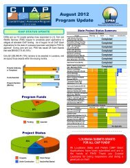
barrier island status report - Coastal Protection and Restoration ...
barrier island status report - Coastal Protection and Restoration ...
barrier island status report - Coastal Protection and Restoration ...

Create successful ePaper yourself
Turn your PDF publications into a flip-book with our unique Google optimized e-Paper software.
Figure 21. 1870s to 2006-07 seafloor change from Breton Isl<strong>and</strong> to Hewes Point. Note the<br />
large magnitude of erosion on the center shoreface as well as the large deposition zones at each<br />
terminal end of the arc. (UNO/PIES)<br />
Figure 22. 1880s to 2005 seafloor change from Raccoon Point to S<strong>and</strong>y Point. Note the<br />
large magnitude of erosion fronting the Caminada Headl<strong>and</strong> <strong>and</strong> the Plaquemines <strong>barrier</strong><br />
shoreline, as well as the deposition at ebb-tidal deltas in the coastal bights at Cat Isl<strong>and</strong> Pass <strong>and</strong><br />
the Barataria Inlets. The map coordinate system is UTM Zone 15 N meters. The 1880s<br />
bathymetry is from List et al. (1994). Shoreline data are from Martinez et al. (2009). (Miner et<br />
al., 2009).<br />
32 | P a g e