Upper Hurunui Photo Album
Upper Hurunui Photo Album
Upper Hurunui Photo Album

You also want an ePaper? Increase the reach of your titles
YUMPU automatically turns print PDFs into web optimized ePapers that Google loves.
H<br />
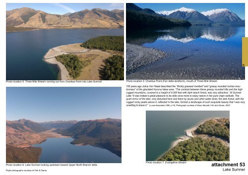
<strong>Photo</strong> location 5: Three Mile Stream running out from Charleys Point into Lake Sumner<br />
<strong>Photo</strong> location 5: Charleys Point (Fan delta landform), mouth of Three Mile Stream<br />
150 years ago Julius Von Haast described the “thickly grassed riverbed” and “grassy rounded roches moutonnees”<br />
of the glaciated <strong>Hurunui</strong> lakes area. “The contrast between these grassy rounded hills and the high<br />
rugged mountains, covered to a height of 4,000 feet with dark beech forest, was very attractive.” At Sumner<br />
Lake “It was indeed a great pleasure to be able once more to enjoy nature in her pure virgin solitude. The<br />
quiet mirror of the lake, only disturbed here and there by ducks and other water birds; the dark forest, with the<br />
rugged rocky peaks above it, reflected in the lake, formed a landscape of such exquisite beauty that I was very<br />
unwilling to leave it.” (Lucas Associates,1995. p.16). <strong>Photo</strong>graph courtesty of Shaun Barnett, Fish and Game, 2007.<br />
Flight photographs courtesy of Fish & Game<br />
<strong>Photo</strong> location 7: Evangeline Stream<br />
<strong>Photo</strong> location 6: Lake Sumner looking upstream toward <strong>Upper</strong> North Branch delta attachment 53<br />
Lake Sumner