Upper Hurunui Photo Album
Upper Hurunui Photo Album
Upper Hurunui Photo Album

Create successful ePaper yourself
Turn your PDF publications into a flip-book with our unique Google optimized e-Paper software.
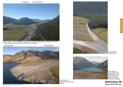
Macs Knob<br />
Mount Longfellow<br />
H<br />
<strong>Photo</strong> location 1: <strong>Upper</strong> North Branch floodplain & river flats, coalescing fans and isolated mountain.<br />
Looking downstream toward Macs Knob and Mount Longfellow.<br />
Woolshed Ridge<br />
Crawford Range<br />
<strong>Photo</strong> location 2:<br />
Landslip Stream<br />
Flight photographs courtesy of Fish & Game<br />
<strong>Photo</strong> location 4:<br />
<strong>Upper</strong> North Branch delta<br />
landform.<br />
<strong>Photo</strong> location 4:<br />
<strong>Upper</strong> North Branch<br />
delta landform. Looking<br />
downstream toward<br />
Lake Sumner<br />
and Mount Longfellow.<br />
attachment 49<br />
<strong>Upper</strong> North Branch