Upper Hurunui Photo Album
Upper Hurunui Photo Album
Upper Hurunui Photo Album

You also want an ePaper? Increase the reach of your titles
YUMPU automatically turns print PDFs into web optimized ePapers that Google loves.
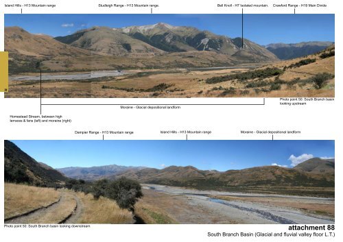
Island Hills - H13 Mountain range<br />
Studleigh Range - H13 Mountain range.<br />
Bell Knoll - H7 Isolated mountain.<br />
Crawford Range - H19 Main Divide<br />
H<br />
Moraine - Glacial depositional landform<br />
<strong>Photo</strong> point 50: South Branch basin<br />
looking upstream<br />
Homestead Stream, between high<br />
terraces & fans (left) and moraine (right)<br />
Dampier Range - H13 Mountain range<br />
Island Hills - H13 Mountain range<br />
Moraine - Glacial depositional landform<br />
<strong>Photo</strong> point 50: South Branch basin looking downstream<br />
attachment 88<br />
South Branch Basin (Glacial and fluvial valley floor L.T.)