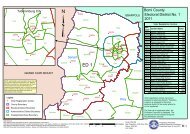
View map - National Elections Commission
View map - National Elections Commission
View map - National Elections Commission

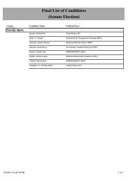
Create successful ePaper yourself
Turn your PDF publications into a flip-book with our unique Google optimized e-Paper software.
Bassa Town<br />
Flahn Town<br />
Topoe Village<br />
New Georgia Estate<br />
Somalia Drive<br />
Iron Factory<br />
Ward SixStreet/Road<br />
Monrovia<br />
SOS Transit<br />
New Georgia Estate Road<br />
New Georgia Township<br />
Chocolate City A<br />
New Georgia<br />
Chocolate City B<br />
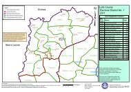
NOTE: Administrative unit boundaries shown here do<br />
not represent official endorsement by the <strong>National</strong><br />
<strong>Elections</strong> <strong>Commission</strong> or the Government of Liberia.<br />
The process for the accurate demarcation and<br />
<strong>map</strong>ping of administrative units is currently on-going.<br />
Upon completion of this process, the Government of<br />
Liberia shall release the official boundaries for<br />
administrative units of Liberia<br />
Legend<br />
" Voter Registration Center<br />
County Boundary<br />
Electoral District Boundary<br />
City/Township Boundary<br />
Amalgamated Area Boundary<br />
Old Field Gulf/Sign Board<br />
Somalia Drive<br />
"<br />
30159<br />
Grass Field<br />
St. Michael<br />
J.J.Y. - Snow Hill<br />
Duan Town<br />
30157<br />
"<br />
Gardnersville Township<br />
Mangrove Island<br />
Old Field South<br />
"<br />
30171<br />
Barnersville Estate<br />
Barnersville Road<br />
J.E. Marshall<br />
Somalia Drive<br />
Barnersville Road<br />
"<br />
Barnersville Road<br />
30172<br />
ED 12<br />
Kesselly Boulevard<br />
Dabwe Town Johnsonville Road B<br />
Shoe Factory<br />
30281<br />
"<br />
30264<br />
"<br />
Somalia Drive<br />
30217<br />
MTA<br />
"<br />
"<br />
30216<br />
30265<br />
River <strong>View</strong><br />
"<br />
30010<br />
30166<br />
" "<br />
30165 30167<br />
30164<br />
Bardnersville Township<br />
Barnersville Road<br />
Day Break Mouth Open<br />
"<br />
Johnsonville Road A<br />
LPRC Road<br />
30282<br />
Somalia Drive<br />
"<br />
LPRC Road<br />
LPRC Road<br />
30055<br />
Somalia Drive<br />
"<br />
"<br />
30051<br />
" 30052<br />
30054<br />
30295<br />
"<br />
30294<br />
30053<br />
"<br />
Stephen Tolbert Estate<br />
Somalia Drive<br />
Chicken Soup Factory<br />
Ward Nine<br />
Paynesville<br />
Lower Johnsonville<br />
Johnsonville Township<br />
Somalia Drive<br />
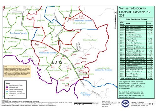
Montserrado County<br />
³Electoral District No. 12<br />
2011<br />
Voter Registration Centers<br />
VRC<br />
Name Total<br />
Code<br />
30010 West African Christian Inst. 607<br />
30051 Wells-Hairston School 2,574<br />
30052 Wells-Hairston School 1,876<br />
30053 A.G.M. School 1,546<br />
30054 Christain David School 944<br />
30055<br />
Free Penticostal Global<br />
Mission Church 1,762<br />
30157 St. Philip School 2,959<br />
30159 James Tue High School 1,289<br />
30164<br />
Emmanuel Comm.<br />
Polytechnic Jr. & Sr. School 1,683<br />
30165<br />
Emmanuel Comm.<br />
Polytechnic Jr. & Sr. School 1,472<br />
30166 Euphemia Abdullia Sch. 793<br />
30167 Euphemia Abdullia Sch. 851<br />
30171 Star International Academy 1,576<br />
30172 Wisdom Home Heritage Sch. 955<br />
30216 St. Magarette School System 1,710<br />
30217 Liberia Christian Comm. Col. 2,415<br />
30264 OPHANAGE/WACI 529<br />
30265 Maranatha A.G.M School 1,035<br />
30281 Picoli Preparatory School 1,913<br />
30282 Richand Hunter School 2,417<br />
30294 Special Project School 1,478<br />
30295 Wesleyan School 1,680<br />
Total Registrants (After Exhibition):<br />
Voter registration centers have been<br />
assigned to electoral districts. Therefore,<br />
a person is assigned to the same<br />
electoral district of the center where he<br />
or she registered.<br />
The final roll of registrants (after the<br />
Exhibition Exercise) is displayed. The<br />
provisional roll was utilized during the<br />
the delineation exercise.<br />
34,064<br />
Data Sources:<br />
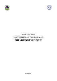
2011 <strong>National</strong> Voter Registration Exercise- <strong>National</strong> <strong>Elections</strong> <strong>Commission</strong>s<br />
2009-2010 Administrative Boundary & Locality Revalidation Project - Inter-Agency Taskforce on Delimitation (IATD: MIA, MLME, NEC, LISGIS)<br />
2007 <strong>National</strong> Geographic Planning - LIberia Institute of Statistics & Geo-Information Services (LISGIS)<br />
2006-2007 Boundary Harmonization Exercise - Special Joint Stakeholders Collaborative Committee (SJSCC)<br />
Kilometers<br />
0 0.25 0.5 1<br />
Scale: 30,000<br />
Map Projection: UTM Zone 29N<br />
Datum: WGS 84<br />
Unit: Meter<br />
Prepared & Printed By:<br />
<strong>National</strong> <strong>Elections</strong> <strong>Commission</strong><br />
Production Date: 29 July 2011<br />
M 51