View map - National Elections Commission
View map - National Elections Commission
View map - National Elections Commission

You also want an ePaper? Increase the reach of your titles
YUMPU automatically turns print PDFs into web optimized ePapers that Google loves.
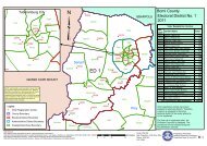
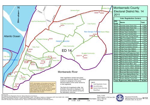
Fish Town<br />
West Point Township<br />
"<br />
Vai Town A<br />
30337<br />
U. N. Drive<br />
30338<br />
"<br />
30339<br />
³<br />
Atlantic Ocean<br />
"<br />
30139<br />
Vai Town B<br />
"<br />
30249<br />
30250<br />
Central Clara Town II<br />
30267 30268<br />
30033<br />
"<br />
"<br />
30266 " 30031<br />
30034<br />
30030<br />
Giblata<br />
Clara Town<br />
Clara Town<br />
Freeport<br />
"<br />
30032<br />
Central Clara Town I<br />
Freeport<br />
Free Port Development<br />
Paity Town<br />
Peugeot Garage<br />
Freeport<br />
"<br />
"<br />
30253<br />
U. N. Drive<br />
30150<br />
"<br />
30151<br />
30035<br />
River <strong>View</strong><br />
Clara Town<br />
NOTE: Administrative unit boundaries shown here do<br />
not represent official endorsement by the <strong>National</strong><br />
<strong>Elections</strong> <strong>Commission</strong> or the Government of Liberia.<br />
The process for the accurate demarcation and<br />
<strong>map</strong>ping of administrative units is currently on-going.<br />
Upon completion of this process, the Government of<br />
Liberia shall release the official boundaries for<br />
administrative units of Liberia<br />
Free Port Community<br />
30254<br />
"<br />
Garglorh Township<br />
Jamaica Road<br />
Somalia Drive<br />
Hope Community<br />
ED 14<br />
Montserado River<br />
30297<br />
"<br />
"<br />
30301<br />
30300<br />
Voter registration centers have been<br />
assigned to electoral districts. Therefore,<br />
a person is assigned to the same<br />
electoral district of the center where he<br />
or she registered.<br />
The final roll of registrants (after the<br />
Exhibition Exercise) is displayed. The<br />
provisional roll was utilized during the<br />
the delineation exercise.<br />
Cow Factory<br />
30068<br />
30298<br />
30299 "<br />
Struggle Community<br />
"<br />
Stockton Creek<br />
30069<br />
New Georgia Township Topoe Village<br />
Legend<br />
" Voter Registration Center<br />
County Boundary<br />
Electoral District Boundary<br />
Street/Road<br />
Montserrado County<br />
Electoral District No. 14<br />
2011<br />
VRC<br />
Code<br />
Voter Registration Centers<br />
Name<br />
Total<br />
30030 Central Clara Town Hut 1,996<br />
30031 Central Clara Town Hut 1,998<br />
30032 Fanina Isaac School 1,524<br />
30033 Clara Town Central Sch. 1,046<br />
30034 Clara Town Central Sch. 872<br />
30035 James Doe Young School 1,979<br />
30068 Mac Foundation School 1,452<br />
30069 Mac Foundation School 1,366<br />
30139 Savaco Community School 2,247<br />
30150 Royal Foundation School 809<br />
30151 Royal Foundation School 997<br />
30249 Paity Town Gas Station 656<br />
30250 Paity Town Gas Station 670<br />
30253 Ophelia Hoff Saytuman Sch. 1,115<br />
30254 Timosa Elementary School 2,101<br />
30266 Marvia Sonu Elem. School 1,071<br />
30267 Marvia Sonu Elem. School 1,101<br />
30268 Marvia Sonu Elem. School 920<br />
30297 Maude Popla Mem. Sch. 2,490<br />
30298 S.K.D. Comm. Elem. School 1,463<br />
30299 S.K.D. Comm. Elem. School 1,504<br />
30300 Busroad Memorial Institute 1,234<br />
30301 Busroad Memorial Institute 955<br />
30337 Vai Town Market Block Fac. 2,758<br />
30338 Imam Adullah Tunis Sch. 1,280<br />
30339 Imam Adullah Tunis Sch. 1,276<br />
Total Registrants (After Exhibition):<br />
36,880<br />
Data Sources:<br />
2011 <strong>National</strong> Voter Registration Exercise- <strong>National</strong> <strong>Elections</strong> <strong>Commission</strong>s<br />
2009-2010 Administrative Boundary & Locality Revalidation Project - Inter-Agency Taskforce on Delimitation (IATD: MIA, MLME, NEC, LISGIS)<br />
2007 <strong>National</strong> Geographic Planning - LIberia Institute of Statistics & Geo-Information Services (LISGIS)<br />
2006-2007 Boundary Harmonization Exercise - Special Joint Stakeholders Collaborative Committee (SJSCC)<br />
0 0.125 0.25 0.5<br />
Kilometers<br />
Scale: 12,500<br />
Map Projection: UTM Zone 29N<br />
Datum: WGS 84<br />
Unit: Meter<br />
Prepared & Printed By:<br />
<strong>National</strong> <strong>Elections</strong> <strong>Commission</strong><br />
Production Date: 29 July 2011<br />
M 53