View map - National Elections Commission
View map - National Elections Commission
View map - National Elections Commission

Create successful ePaper yourself
Turn your PDF publications into a flip-book with our unique Google optimized e-Paper software.
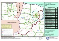
Central Johnsonville<br />
Johnsonville Road A<br />
Mount Barclay<br />
Lower Johnsonville<br />
Johnsonville Township<br />
Chicken Soup Factory<br />
Barnard Farm<br />
Rock Hill<br />
City <strong>View</strong><br />
Stephen Tolbert Estate<br />
Pipeline B<br />
Ward Seven<br />
Zinc Factory<br />
Morris Farm<br />
Somalia Drive<br />
Double Bridge<br />
Ward Nine<br />
Jacob Town<br />
Paynesville<br />
Ward Six<br />
72nd Community<br />
Tubman Boulevard<br />
SKD Bouldevard<br />
Neezoe Road<br />
Somalia Drive<br />
AB Tolbert Road<br />
Pipeline Road<br />
Ward Eight<br />
Pipe LineA<br />
Neezoe<br />
Tubman Boulevard<br />
GSA Road<br />
Rehab Road<br />
30278<br />
Monrovia-Kakata Road<br />
30279<br />
"<br />
"<br />
30110<br />
30117<br />
Kemah Town/Omega<br />
Wood Camp<br />
Ward Five<br />
Red Light<br />
Bassa Town<br />
Soul Clinic<br />
Police Academy<br />
30128Duport Road North<br />
"<br />
Swankamore Ward One<br />
30129<br />
" 30122<br />
"<br />
Pagos Island<br />
Duport Road N. East<br />
A.B Tolbert Road<br />
30127<br />
30119<br />
"<br />
Congo Town<br />
Town Hall<br />
Ward Four<br />
30120<br />
30125<br />
"<br />
Congo Town<br />
30123<br />
30124<br />
" "<br />
30126"<br />
Congo Town Old Rd<br />
Duport Road South<br />
Paynesville Joe Bar<br />
S.D Copper<br />
GSA Road Rockville<br />
Ward Two Kpelle Town<br />
Rehab/Borbor Town<br />
King Gray-Elwa<br />
Ward Three<br />
"<br />
"<br />
"<br />
30115<br />
" 30114<br />
"<br />
"<br />
"<br />
30113<br />
Duport Road<br />
"<br />
30116<br />
30111<br />
ED 4<br />
30109<br />
30108<br />
"<br />
30112<br />
Fendell<br />
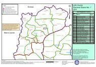
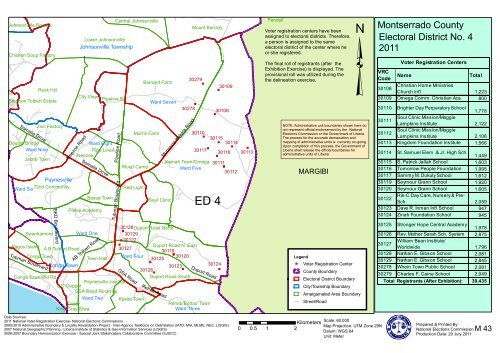
Voter registration centers have been<br />
assigned to electoral districts. Therefore,<br />
a person is assigned to the same<br />
electoral district of the center where he<br />
or she registered.<br />
The final roll of registrants (after the<br />
Exhibition Exercise) is displayed. The<br />
provisional roll was utilized during the<br />
the delineation exercise.<br />
MARGIBI<br />
Legend<br />
" Voter Registration Center<br />
County Boundary<br />
Electoral District Boundary<br />
City/Township Boundary<br />
³<br />
NOTE: Administrative unit boundaries shown here do<br />
not represent official endorsement by the <strong>National</strong><br />
<strong>Elections</strong> <strong>Commission</strong> or the Government of Liberia.<br />
The process for the accurate demarcation and<br />
<strong>map</strong>ping of administrative units is currently on-going.<br />
Upon completion of this process, the Government of<br />
Liberia shall release the official boundaries for<br />
administrative units of Liberia<br />
Amalgamated Area Boundary<br />
Street/Road<br />
Montserrado County<br />
Electoral District No. 4<br />
2011<br />
Voter Registration Centers<br />
VRC<br />
Name<br />
Total<br />
Code<br />
Christian Home Ministries<br />
30108<br />
Church Int'l 1,223<br />
30109 Omega Comm. Christian Aca. 800<br />
30110 Brighter Day Perparatory School<br />
1,778<br />
30111<br />
Soul Clinic Mission/Maggie<br />
Lampkins Institute 2,122<br />
30112<br />
Soul Clinic Mission/Maggie<br />
Lampkins Institute 2,106<br />
30113 Kingdom Foundation Institute 1,566<br />
30114 St. Samuel Elem .& Jr. High Sch.<br />
1,449<br />
30115 S. Patrick Jallah School 1,603<br />
30116 Tomorrow People Foundation 1,995<br />
30117 Sammy M. Dukuly School 1,612<br />
30119 Seymour Grann School 1,920<br />
30120 Seymour Grann School 1,605<br />
30122<br />
Rik-C Day Care, Nursery & Pre-<br />
Sch. 2,059<br />
30123 Dave R. Inman Int'l School 947<br />
30124 Zinah Foundation School 945<br />
30125 Stronger Hope Central Academy<br />
1,978<br />
30126 Rev. Mother Sarah Sch. System 2,875<br />
30127<br />
William Bean Institute/<br />
Worldwide 1,796<br />
30128 Nathan E. Gibson School 2,081<br />
30129 Nathan E. Gibson School 2,845<br />
30278 Whein Town Public School 2,081<br />
30279 Charles F. Caine School 2,049<br />
Total Registrants (After Exhibition):<br />
39,435<br />
Data Sources:<br />
2011 <strong>National</strong> Voter Registration Exercise- <strong>National</strong> <strong>Elections</strong> <strong>Commission</strong>s<br />
2009-2010 Administrative Boundary & Locality Revalidation Project - Inter-Agency Taskforce on Delimitation (IATD: MIA, MLME, NEC, LISGIS)<br />
2007 <strong>National</strong> Geographic Planning - LIberia Institute of Statistics & Geo-Information Services (LISGIS)<br />
2006-2007 Boundary Harmonization Exercise - Special Joint Stakeholders Collaborative Committee (SJSCC)<br />
0 0.5 1 2<br />
Scale: 60,000<br />
Kilometers Map Projection: UTM Zone 29N<br />
Datum: WGS 84<br />
Unit: Meter<br />
Prepared & Printed By:<br />
<strong>National</strong> <strong>Elections</strong> <strong>Commission</strong><br />
Production Date: 29 July 2011<br />
M 43