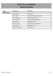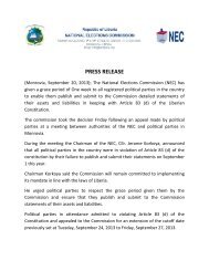
View map - National Elections Commission
View map - National Elections Commission
View map - National Elections Commission

Create successful ePaper yourself
Turn your PDF publications into a flip-book with our unique Google optimized e-Paper software.
Two<br />
³<br />
Sundufu<br />
BOMI<br />
Dineekon<br />
Bonowah<br />
Todee<br />
Gbarveah<br />
Upper D'lng<br />
"<br />
30191<br />
Lower D'lng<br />
30195<br />
"<br />
Lower Markoi<br />
30330<br />
"<br />
30215<br />
"<br />
Mount Coffee General<br />
30196Lower Mein<br />
"<br />
30333<br />
"<br />
Upper Markoi<br />
Upper " Mein Lower Kpo<br />
30334<br />
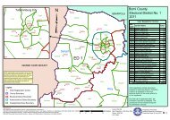
ED 1<br />
Upper Nyehn<br />
30335<br />
"<br />
Kpannahlolo Two<br />
30170<br />
"<br />
Kartoe One<br />
BONG<br />
Upper Kpo<br />
" "<br />
30331<br />
30436<br />
"<br />
Yarkpazuah Three<br />
30435<br />
"<br />
Fahn-Seh<br />
30103<br />
"<br />
"<br />
30102<br />
Central Arthington<br />
Bahr<br />
Harrisburg General<br />
" 30003 30002<br />
Upper Virginia<br />
30149<br />
Lower Nyehn<br />
" Grimes<br />
Kaikpu<br />
"<br />
30140<br />
"<br />
30147<br />
One<br />
Millsburg General<br />
30148<br />
Gomoshu<br />
"<br />
"<br />
Barcon<br />
Crozierville General<br />
30194<br />
30329<br />
"<br />
Luneh "<br />
30197<br />
30433<br />
Dee<br />
" 30328<br />
"<br />
"<br />
30072<br />
Upper Careysburg<br />
Goyah<br />
" Kpayaquelleh<br />
30432<br />
30180<br />
"<br />
Five Seven<br />
Tolbert "<br />
30141<br />
Four Bassa Tribal 30189White Plains " General<br />
"<br />
Fagans " "<br />
Central Virginia Louisiana 30434<br />
Six<br />
30138 30101<br />
Eight<br />
Central Careysburg 30177<br />
Nine<br />
Kolliemai<br />
"<br />
"<br />
30028<br />
" 30270<br />
30178Kingsville General<br />
Lower VirginiaDixville Water Side<br />
"<br />
"<br />
Samukai Town Sasstown<br />
30190<br />
30179<br />
Caldwell Market<br />
"<br />
"<br />
30029<br />
30104<br />
Tweh Farm<br />
Lower Careysburg<br />
Cassava Hill<br />
Fendall "<br />
Crab Hole Dixville B<br />
Kaba Town<br />
30105<br />
Vicky Spot Central Johnsonville<br />
Duan Town<br />
Mount Barclay<br />
Grass FieldLower Johnsonville<br />
30332<br />
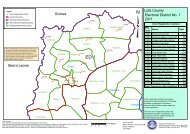
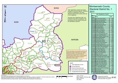
Voter registration centers have been<br />
assigned to electoral districts. Therefore,<br />
a person is assigned to the same<br />
electoral district of the center where he<br />
or she registered.<br />
The final roll of registrants (after the<br />
Exhibition Exercise) is displayed. The<br />
provisional roll was utilized during the<br />
the delineation exercise.<br />
MARGIBI<br />
NOTE: Administrative unit boundaries shown here do<br />
not represent official endorsement by the <strong>National</strong><br />
<strong>Elections</strong> <strong>Commission</strong> or the Government of Liberia.<br />
The process for the accurate demarcation and<br />
<strong>map</strong>ping of administrative units is currently on-going.<br />
Upon completion of this process, the Government of<br />
Liberia shall release the official boundaries for<br />
administrative units of Liberia<br />
Legend<br />
" Voter Registration Center<br />
County Boundary<br />
Electoral District Boundary<br />
Administrative District Boundary<br />
Amalgamated Area Boundary<br />
Montserrado County<br />
Electoral District No. 1<br />
2011<br />
VRC<br />
Code<br />
Voter Registration Centers<br />
Name<br />
Total<br />
30002 Goba Town Public School 1,166<br />
30003 Sackie Town Public School 621<br />
30028 Careysburg High School 812<br />
30029 Careysburg Admin Building 1,014<br />
30072 Crozierville Town Hall 1,069<br />
30101 Euphemial Barclay School 1,250<br />
30102 Morris Farm School 1,968<br />
30103 Blopa Public School 726<br />
30104 Fendall Public School 646<br />
30105 Fendall U.L. Palava Hut 1,891<br />
30138 Children Home School 894<br />
30140 Youth Camp Auditorium 1,322<br />
30141 Freeman Reserved Public Sch. 834<br />
30147 Bernand Curve Palava Hut 636<br />
30148 David A. Day Mem. Lutheran Sch. 325<br />
30149 Raymond Camp School 347<br />
30170 Kartoe Public School 550<br />
30177 Kingsville Public School 1,506<br />
30178 Kingsville Public School 1,559<br />
30179 15th Gate Community School 814<br />
30180 Kpayaquelleh Palava Hut 377<br />
30189 Louisiana Waterside Comm. Sch. 419<br />
30190 King's Farm Community School 1,235<br />
30191 Mary Paye Farm Public School 490<br />
30194 Gwee Town Palava Hut 769<br />
30195 Tarquoi Town Palava Hut 423<br />
30196 Koon Town Public School 1,285<br />
30197 Manamu Town Palava Hut 516<br />
30215 Zingbor Town Hall 777<br />
30270 Sasstown Community School 444<br />
30328 New Land IDP Camp Comm. Hall 374<br />
30329 New Land IDP Camp Comm. Hall 447<br />
30330 Clean Town Palava Hut 500<br />
30331 Zannah Town Public School 1,200<br />
30332 Moisee Town Public School 244<br />
30333 Yeakpai Town Public School 1,110<br />
30334 Yeagbah Town Public School 753<br />
30335 Nyehn Town Public School 1,398<br />
30432 C. H. Henry Public School 127<br />
30433 Jesus Christ Children Int'l School 221<br />
30434 Hart Town Hall 221<br />
30435 Yarkpazuah Palava Hut 1,021<br />
30436 Pleemu Public School 1,459<br />
Total Registrants (After Exhibition):<br />
35,760<br />
Data Sources:<br />
2011 <strong>National</strong> Voter Registration Exercise- <strong>National</strong> <strong>Elections</strong> <strong>Commission</strong>s<br />
2009-2010 Administrative Boundary & Locality Revalidation Project - Inter-Agency Taskforce on Delimitation (IATD: MIA, MLME, NEC, LISGIS)<br />
2007 <strong>National</strong> Geographic Planning - LIberia Institute of Statistics & Geo-Information Services (LISGIS)<br />
2006-2007 Boundary Harmonization Exercise - Special Joint Stakeholders Collaborative Committee (SJSCC)<br />
Kilometers<br />
0 2 4 8<br />
Scale: 310,000<br />
Map Projection: UTM Zone 29N<br />
Datum: WGS 84<br />
Unit: Meter<br />
Prepared & Printed By:<br />
<strong>National</strong> <strong>Elections</strong> <strong>Commission</strong><br />
Production Date: 29 July 2011<br />
M 40
30192<br />
"<br />
Dabwe Town<br />
Barnersville Road<br />
LPRC Road<br />
Samukai Town<br />
Dixville BDixville Township<br />
Somalia Drive<br />
Chicken Soup Factory<br />
Kaba Town<br />
Bardnersville Township<br />
Behwein Community<br />
Johnsonville Road B<br />
Johnsonville Road A<br />
Barnersville Road<br />
Day Break Mouth Open<br />
Gardnersville Township<br />
Chicken Soup Factory<br />
MTA<br />
Cardwell Township<br />
Rock Hill<br />
Stephen Tolbert Estate<br />
River <strong>View</strong><br />
30193<br />
"<br />
30225 Zinc Factory<br />
30224 " "<br />
"<br />
30231<br />
30223 30226<br />
" 30091<br />
Double Bridge 30230<br />
"<br />
30232<br />
"<br />
30227 Ward Nine<br />
"<br />
Jacob Town "<br />
"<br />
30229 30228<br />
Cassava Hill<br />
Lower Johnsonville<br />
"<br />
"<br />
Neezoe Road<br />
30100<br />
30099<br />
"<br />
City <strong>View</strong> Pipeline B<br />
Somalia Drive<br />
Pipeline Road<br />
Ward Eight<br />
Pipe LineA<br />
Neezoe<br />
30036<br />
Central Johnsonville<br />
Sasstown<br />
"<br />
Johnsonville Township<br />
ED 2<br />
Paynesville<br />
Morris Farm<br />
Wood Camp<br />
72nd Community<br />
Ward Six<br />
Bassa Town Red LightSoul Clinic<br />
Ward Six<br />
Barnard Farm<br />
Ward Seven<br />
Monrovia-Kakata Road<br />
Data Sources:<br />
2011 <strong>National</strong> Voter Registration Exercise- <strong>National</strong> <strong>Elections</strong> <strong>Commission</strong>s<br />
2009-2010 Administrative Boundary & Locality Revalidation Project - Inter-Agency Taskforce on Delimitation (IATD: MIA, MLME, NEC, LISGIS)<br />
2007 <strong>National</strong> Geographic Planning - LIberia Institute of Statistics & Geo-Information Services (LISGIS)<br />
2006-2007 Boundary Harmonization Exercise - Special Joint Stakeholders Collaborative Committee (SJSCC)<br />
Mount Barclay<br />
"<br />
Monrovia-Kakata Road<br />
30214<br />
Kemah Town/Omega<br />
Ward Five<br />
"<br />
Louisiana Township<br />
30213<br />
Fendell<br />
Legend<br />
MARGIBI<br />
" Voter Registration Center<br />
County Boundary<br />
Lower Careysburg<br />
Electoral District Boundary<br />
City/Township Boundary<br />
Amalgamated Area Boundary<br />
Street/Road<br />
Kilometers<br />
0 0.5 1 2<br />
NOTE: Administrative unit boundaries shown here do<br />
not represent official endorsement by the <strong>National</strong><br />
<strong>Elections</strong> <strong>Commission</strong> or the Government of Liberia.<br />
The process for the accurate demarcation and<br />
<strong>map</strong>ping of administrative units is currently on-going.<br />
Upon completion of this process, the Government of<br />
Liberia shall release the official boundaries for<br />
administrative units of Liberia<br />
Scale: 65,000<br />
Map Projection: UTM Zone 29N<br />
Datum: WGS 84<br />
Unit: Meter<br />
Montserrado County<br />
Electoral District No. 2<br />
2011<br />
Voter Registration Centers<br />
VRC<br />
Code<br />
Name<br />
Total<br />
30036 Johnsonville Public School 1,577<br />
30091 Fairfield Baptist School 1,870<br />
30099 Hope For Life School 1,539<br />
30100 Our Lady of Fatama School 2,699<br />
30192<br />
Light Enterprises Academy &<br />
Vocational School System 1,832<br />
30193 YMCA - Nekely Town 2,074<br />
30213 NRC School 1,785<br />
30214 Child Friendly Space 1,125<br />
30223 Monrovia Vocational Training Cen. 2,307<br />
30224 Monrovia Vocational Training Cen. 1,754<br />
30225 New Hope Academy 2,029<br />
30226 Bassa Town Community School 607<br />
30227 St. Francis School 3,106<br />
30228 Calvary Temple A.G.M. High Sch. 2,155<br />
30229 Calvary Temple A.G.M. High Sch. 2,170<br />
30230 Ma Bendu I. Sheriff School 1,855<br />
30231<br />
Muslim Solidarity Arabic & English<br />
School 2,327<br />
30232 Star Baptist School 1,685<br />
Total Registrants (After Exhibition):<br />
Voter registration centers have been<br />
assigned to electoral districts. Therefore,<br />
a person is assigned to the same<br />
electoral district of the center where he<br />
or she registered.<br />
The final roll of registrants (after the<br />
Exhibition Exercise) is displayed. The<br />
provisional roll was utilized during the<br />
the delineation exercise.<br />
34,496<br />
Prepared & Printed By:<br />
<strong>National</strong> <strong>Elections</strong> <strong>Commission</strong><br />
Production Date: 29 July 2011³<br />
M 41
Rock Hill<br />
Zinc Factory<br />
Ward Nine<br />
Jacob Town<br />
SKD Bouldevard<br />
Neezoe Road<br />
City <strong>View</strong><br />
Neezoe<br />
72nd Community<br />
30092<br />
"<br />
"<br />
30093<br />
Somalia Drive<br />
Lower Johnsonville<br />
Johnsonville Township<br />
"<br />
30094<br />
Ward Eight<br />
Pipe LineA<br />
30288<br />
"<br />
30283<br />
"<br />
30095<br />
"<br />
Bassa Town<br />
30097<br />
"<br />
"<br />
30096<br />
Pipeline B<br />
Pipeline Road<br />
ED 3<br />
Morris Farm<br />
Wood Camp<br />
"<br />
30271<br />
"<br />
Ward Six<br />
Red Light<br />
Central Johnsonville<br />
"<br />
"<br />
30274<br />
30276<br />
30273<br />
"<br />
30280<br />
30272<br />
"<br />
Barnard Farm<br />
Ward Seven<br />
30275<br />
Soul Clinic<br />
"<br />
Paynesville<br />
"<br />
30277<br />
Monrovia-Kakata Road<br />
Ward Five<br />
Mount Barclay<br />
Monrovia-Kakata Road<br />
Kemah Town/Omega<br />
³<br />
NOTE: Administrative unit boundaries shown here do<br />
not represent official endorsement by the <strong>National</strong><br />
<strong>Elections</strong> <strong>Commission</strong> or the Government of Liberia.<br />
The process for the accurate demarcation and<br />
<strong>map</strong>ping of administrative units is currently on-going.<br />
Upon completion of this process, the Government of<br />
Liberia shall release the official boundaries for<br />
administrative units of Liberia<br />
Legend<br />
" Voter Registration Center<br />
County Boundary<br />
Electoral District Boundary<br />
City/Township Boundary<br />
Amalgamated Area Boundary<br />
Street/Road<br />
Montserrado County<br />
Electoral District No. 3<br />
2011<br />
VRC<br />
Code<br />
Voter Registration Centers<br />
Name Total<br />
30092 Aaron G. Burgess Momerial Aca. 2,363<br />
30093 Christian Methodist School 1,977<br />
30094 New Jerusalem Baptist Church 2,619<br />
30095 Salvation Army 3,003<br />
30096 Int'l Christian Sch. of Prime Sys. 2,102<br />
30097 Small Catholic & IDP Camp 2,120<br />
30271 Revival Temple A.G.M School 2,458<br />
30272 Jawalla Community School 1,691<br />
30273 Billie Call Christian Institute 2,360<br />
30274 Billie Call Christian Institute 2,293<br />
30275 Victorial A. William High Sch. 1,455<br />
30276 Factory Comm. Christian Aca. 2,486<br />
30277 Practical Trade Training Cen. 2,886<br />
30280 Messiah Mission School 1,893<br />
30283 David G. Barshell Sr. School 2,730<br />
30288 Paynesville Central Aca. 3,600<br />
Total Registrants (After Exhibition):<br />
Voter registration centers have been<br />
assigned to electoral districts. Therefore,<br />
a person is assigned to the same<br />
electoral district of the center where he<br />
or she registered.<br />
The final roll of registrants (after the<br />
Exhibition Exercise) is displayed. The<br />
provisional roll was utilized during the<br />
the delineation exercise.<br />
38,036<br />
Data Sources:<br />
2011 <strong>National</strong> Voter Registration Exercise- <strong>National</strong> <strong>Elections</strong> <strong>Commission</strong>s<br />
2009-2010 Administrative Boundary & Locality Revalidation Project - Inter-Agency Taskforce on Delimitation (IATD: MIA, MLME, NEC, LISGIS)<br />
2007 <strong>National</strong> Geographic Planning - LIberia Institute of Statistics & Geo-Information Services (LISGIS)<br />
2006-2007 Boundary Harmonization Exercise - Special Joint Stakeholders Collaborative Committee (SJSCC)<br />
Kilometers<br />
0 0.25 0.5 1<br />
Scale: 35,000<br />
Map Projection: UTM Zone 29N<br />
Datum: WGS 84<br />
Unit: Meter<br />
Prepared & Printed By:<br />
<strong>National</strong> <strong>Elections</strong> <strong>Commission</strong><br />
Production Date: 29 July 2011<br />
M 42
Central Johnsonville<br />
Johnsonville Road A<br />
Mount Barclay<br />
Lower Johnsonville<br />
Johnsonville Township<br />
Chicken Soup Factory<br />
Barnard Farm<br />
Rock Hill<br />
City <strong>View</strong><br />
Stephen Tolbert Estate<br />
Pipeline B<br />
Ward Seven<br />
Zinc Factory<br />
Morris Farm<br />
Somalia Drive<br />
Double Bridge<br />
Ward Nine<br />
Jacob Town<br />
Paynesville<br />
Ward Six<br />
72nd Community<br />
Tubman Boulevard<br />
SKD Bouldevard<br />
Neezoe Road<br />
Somalia Drive<br />
AB Tolbert Road<br />
Pipeline Road<br />
Ward Eight<br />
Pipe LineA<br />
Neezoe<br />
Tubman Boulevard<br />
GSA Road<br />
Rehab Road<br />
30278<br />
Monrovia-Kakata Road<br />
30279<br />
"<br />
"<br />
30110<br />
30117<br />
Kemah Town/Omega<br />
Wood Camp<br />
Ward Five<br />
Red Light<br />
Bassa Town<br />
Soul Clinic<br />
Police Academy<br />
30128Duport Road North<br />
"<br />
Swankamore Ward One<br />
30129<br />
" 30122<br />
"<br />
Pagos Island<br />
Duport Road N. East<br />
A.B Tolbert Road<br />
30127<br />
30119<br />
"<br />
Congo Town<br />
Town Hall<br />
Ward Four<br />
30120<br />
30125<br />
"<br />
Congo Town<br />
30123<br />
30124<br />
" "<br />
30126"<br />
Congo Town Old Rd<br />
Duport Road South<br />
Paynesville Joe Bar<br />
S.D Copper<br />
GSA Road Rockville<br />
Ward Two Kpelle Town<br />
Rehab/Borbor Town<br />
King Gray-Elwa<br />
Ward Three<br />
"<br />
"<br />
"<br />
30115<br />
" 30114<br />
"<br />
"<br />
"<br />
30113<br />
Duport Road<br />
"<br />
30116<br />
30111<br />
ED 4<br />
30109<br />
30108<br />
"<br />
30112<br />
Fendell<br />
Voter registration centers have been<br />
assigned to electoral districts. Therefore,<br />
a person is assigned to the same<br />
electoral district of the center where he<br />
or she registered.<br />
The final roll of registrants (after the<br />
Exhibition Exercise) is displayed. The<br />
provisional roll was utilized during the<br />
the delineation exercise.<br />
MARGIBI<br />
Legend<br />
" Voter Registration Center<br />
County Boundary<br />
Electoral District Boundary<br />
City/Township Boundary<br />
³<br />
NOTE: Administrative unit boundaries shown here do<br />
not represent official endorsement by the <strong>National</strong><br />
<strong>Elections</strong> <strong>Commission</strong> or the Government of Liberia.<br />
The process for the accurate demarcation and<br />
<strong>map</strong>ping of administrative units is currently on-going.<br />
Upon completion of this process, the Government of<br />
Liberia shall release the official boundaries for<br />
administrative units of Liberia<br />
Amalgamated Area Boundary<br />
Street/Road<br />
Montserrado County<br />
Electoral District No. 4<br />
2011<br />
Voter Registration Centers<br />
VRC<br />
Name<br />
Total<br />
Code<br />
Christian Home Ministries<br />
30108<br />
Church Int'l 1,223<br />
30109 Omega Comm. Christian Aca. 800<br />
30110 Brighter Day Perparatory School<br />
1,778<br />
30111<br />
Soul Clinic Mission/Maggie<br />
Lampkins Institute 2,122<br />
30112<br />
Soul Clinic Mission/Maggie<br />
Lampkins Institute 2,106<br />
30113 Kingdom Foundation Institute 1,566<br />
30114 St. Samuel Elem .& Jr. High Sch.<br />
1,449<br />
30115 S. Patrick Jallah School 1,603<br />
30116 Tomorrow People Foundation 1,995<br />
30117 Sammy M. Dukuly School 1,612<br />
30119 Seymour Grann School 1,920<br />
30120 Seymour Grann School 1,605<br />
30122<br />
Rik-C Day Care, Nursery & Pre-<br />
Sch. 2,059<br />
30123 Dave R. Inman Int'l School 947<br />
30124 Zinah Foundation School 945<br />
30125 Stronger Hope Central Academy<br />
1,978<br />
30126 Rev. Mother Sarah Sch. System 2,875<br />
30127<br />
William Bean Institute/<br />
Worldwide 1,796<br />
30128 Nathan E. Gibson School 2,081<br />
30129 Nathan E. Gibson School 2,845<br />
30278 Whein Town Public School 2,081<br />
30279 Charles F. Caine School 2,049<br />
Total Registrants (After Exhibition):<br />
39,435<br />
Data Sources:<br />
2011 <strong>National</strong> Voter Registration Exercise- <strong>National</strong> <strong>Elections</strong> <strong>Commission</strong>s<br />
2009-2010 Administrative Boundary & Locality Revalidation Project - Inter-Agency Taskforce on Delimitation (IATD: MIA, MLME, NEC, LISGIS)<br />
2007 <strong>National</strong> Geographic Planning - LIberia Institute of Statistics & Geo-Information Services (LISGIS)<br />
2006-2007 Boundary Harmonization Exercise - Special Joint Stakeholders Collaborative Committee (SJSCC)<br />
0 0.5 1 2<br />
Scale: 60,000<br />
Kilometers Map Projection: UTM Zone 29N<br />
Datum: WGS 84<br />
Unit: Meter<br />
Prepared & Printed By:<br />
<strong>National</strong> <strong>Elections</strong> <strong>Commission</strong><br />
Production Date: 29 July 2011<br />
M 43
Double Bridge<br />
NOTE: Administrative unit boundaries shown here do<br />
not represent official endorsement by the <strong>National</strong><br />
<strong>Elections</strong> <strong>Commission</strong> or the Government of Liberia.<br />
The process for the accurate demarcation and<br />
<strong>map</strong>ping of administrative units is currently on-going.<br />
Upon completion of this process, the Government of<br />
Ward Nine<br />
Liberia shall release the official boundaries for<br />
administrative units of Liberia<br />
Peace Island<br />
Barchue Town<br />
Congo Town<br />
Congo Town<br />
Oldest Congo Town Road<br />
"<br />
Ward Six<br />
Pagos Island<br />
30248<br />
Tubman Boulevard<br />
Jacob Town<br />
Congo Town Old Rd<br />
Paynesville<br />
72nd Community<br />
30303<br />
"<br />
SKD Bouldevard<br />
Swankamore<br />
Zinc Factory<br />
ED 5<br />
SD Cooper Road<br />
"<br />
Neezoe Road<br />
"<br />
30247<br />
30243<br />
30289<br />
"<br />
30246<br />
A.B Tolbert Road<br />
S.D Copper<br />
Neezoe<br />
"<br />
Somalia Drive<br />
30245<br />
Police Academy<br />
Ward One<br />
30287<br />
"<br />
AB Tolbert Road<br />
Data Sources:<br />
2011 <strong>National</strong> Voter Registration Exercise- <strong>National</strong> <strong>Elections</strong> <strong>Commission</strong>s<br />
2009-2010 Administrative Boundary & Locality Revalidation Project - Inter-Agency Taskforce on Delimitation (IATD: MIA, MLME, NEC, LISGIS)<br />
2007 <strong>National</strong> Geographic Planning - LIberia Institute of Statistics & Geo-Information Services (LISGIS)<br />
2006-2007 Boundary Harmonization Exercise - Special Joint Stakeholders Collaborative Committee (SJSCC)<br />
Ward Eight<br />
"<br />
Pipe LineA<br />
30098<br />
"<br />
Bassa Town<br />
30285<br />
Pipeline B<br />
Pipeline Road<br />
Tubman Boulevard<br />
"<br />
"<br />
GSA Road<br />
"<br />
"<br />
30290<br />
Ward Seven<br />
Wood Camp<br />
30284<br />
Red Light<br />
30286<br />
Duport Road North<br />
Duport Road<br />
Morris Farm<br />
Kemah Town/Omega<br />
Ward Five<br />
Soul Clinic<br />
Duport Road N. East<br />
Duport Road<br />
Montserrado County<br />
Electoral District No. 5<br />
2011<br />
VRC<br />
Code<br />
Voter Registration Centers<br />
Name<br />
"<br />
30121<br />
The final roll of registrants (after the<br />
"<br />
30244<br />
Ward Four<br />
Exhibition Exercise) is displayed. The<br />
provisional roll was utilized during the<br />
Town Hall<br />
the delineation exercise.<br />
Duport Road South<br />
Legend<br />
Paynesville Joe Bar<br />
" Voter Registration Center<br />
County Boundary<br />
Ward Two<br />
Electoral District Boundary<br />
GSA Road Rockville<br />
City/Township Boundary<br />
Amalgamated Area Boundary<br />
Kpelle Town<br />
Ward Three<br />
Street/Road<br />
0 0.25 0.5<br />
Scale: 30,000<br />
Kilometers Map Projection: UTM Zone 29N<br />
Prepared & Printed By:<br />
1<br />
Datum: WGS 84<br />
<strong>National</strong> <strong>Elections</strong> <strong>Commission</strong><br />
Production Date: 29 July 2011³<br />
Unit: Meter<br />
Rehab/Borbor Town<br />
Total<br />
30098 Credit Union Building 3,001<br />
30121 Paynesville Community School 3,075<br />
30243 Dyfater School 2,189<br />
30244 Paynesville Town Hall 2,717<br />
30245 Christ Miracle of Faith Sch. Sys. 3,003<br />
30246 Bonner Memorial Christian Aca. 917<br />
30247 Sir Kerry St. Johnston School 1,266<br />
30248 Repentence Baptist School 2,210<br />
30284 St. Mathew Lutheran School 3,011<br />
30285 Victory Chapel School 2,671<br />
30286 Gayee Trade International Sch. 3,488<br />
30287 Kalita School 3,257<br />
30289 Seat of Wisdom School System 3,010<br />
30290 Rock International School 2,648<br />
30303 James Kin Freeman Mem.l Sch. 2,280<br />
Total Registrants (After Exhibition):<br />
Voter registration centers have been<br />
assigned to electoral districts. Therefore,<br />
a person is assigned to the same<br />
electoral district of the center where he<br />
or she registered.<br />
38,743<br />
M 44
Swankamore<br />
Congo Town<br />
Town Old Rd<br />
Tubman Boulevard<br />
"<br />
Police Academy<br />
A.B Tolbert Road<br />
"<br />
S.D Copper<br />
30325<br />
"<br />
GSA Road<br />
Rockville<br />
"<br />
"<br />
King Gray-Elwa<br />
"<br />
"<br />
Kpelle Town<br />
Duport Road North<br />
Town Hall<br />
Paynesville<br />
Joe Bar<br />
30324 30320<br />
ELWA Road<br />
Ward One<br />
30312<br />
Ward Two<br />
30323<br />
30322<br />
GSA Road<br />
30319<br />
ELWA Road<br />
Duport Road South<br />
Rehab Road<br />
"<br />
30321<br />
Paynesville<br />
Ward Four<br />
ED 6<br />
"<br />
30307<br />
Duport Road N. East<br />
Duport Road<br />
Rehab/Borbor Town<br />
30313<br />
ELWA Road<br />
Ward Five<br />
"<br />
Ward Three<br />
"<br />
30311<br />
MARGIBI<br />
³<br />
Montserrado County<br />
Electoral District No. 6<br />
2011<br />
Voter Registration Centers<br />
VRC<br />
Code<br />
Name<br />
Total<br />
30307 Kendejah High School/Rehab 2,223<br />
30308 Kendejah Community School 2,015<br />
30309 Love A Child Ophanage Home 3,011<br />
30310<br />
Helen Teah Memorial Christian<br />
Inst. 3,198<br />
30311 Cavalry Chapel Mission Sch. 2,396<br />
30312 Solid Rock Christian School 2,583<br />
30313<br />
Sis. Kathleen McQuire<br />
Memo.Catholic High School 1,533<br />
30319 Broluco Christian School Sys. 3,001<br />
30320 David Gueh Memorial UMC 2,507<br />
30321 Mount Carmel Institute 2,726<br />
30322 Wilbel Foundation Elem. Sch. 2,024<br />
30323 Carver Mission School 2,999<br />
30324 Seventh Day Adventist Sch. 3,530<br />
30325 Immanuel Christian Aca. 3,000<br />
Total Registrants (After Exhibition):<br />
36,746<br />
"<br />
30308<br />
Kende-jah<br />
"<br />
30310<br />
"<br />
30309<br />
Legend<br />
" Voter Registration Center<br />
County Boundary<br />
Electoral District Boundary<br />
City/Township Boundary<br />
Amalgamated Area Boundary<br />
Street/Road<br />
Atlantic Ocean<br />
NOTE: Administrative unit boundaries shown here do<br />
not represent official endorsement by the <strong>National</strong><br />
<strong>Elections</strong> <strong>Commission</strong> or the Government of Liberia.<br />
The process for the accurate demarcation and<br />
<strong>map</strong>ping of administrative units is currently on-going.<br />
Upon completion of this process, the Government of<br />
Liberia shall release the official boundaries for<br />
administrative units of Liberia<br />
Voter registration centers have been<br />
assigned to electoral districts. Therefore,<br />
a person is assigned to the same<br />
electoral district of the center where he<br />
or she registered.<br />
The final roll of registrants (after the<br />
Exhibition Exercise) is displayed. The<br />
provisional roll was utilized during the<br />
the delineation exercise.<br />
Data Sources:<br />
2011 <strong>National</strong> Voter Registration Exercise- <strong>National</strong> <strong>Elections</strong> <strong>Commission</strong>s<br />
2009-2010 Administrative Boundary & Locality Revalidation Project - Inter-Agency Taskforce on Delimitation (IATD: MIA, MLME, NEC, LISGIS)<br />
2007 <strong>National</strong> Geographic Planning - LIberia Institute of Statistics & Geo-Information Services (LISGIS)<br />
2006-2007 Boundary Harmonization Exercise - Special Joint Stakeholders Collaborative Committee (SJSCC)<br />
0 0.5 1 2<br />
Kilometers<br />
Scale: 50,000<br />
Map Projection: UTM Zone 29N<br />
Datum: WGS 84<br />
Unit: Meter<br />
Prepared & Printed By:<br />
<strong>National</strong> <strong>Elections</strong> <strong>Commission</strong><br />
Production Date: 29 July 2011<br />
M 45
³<br />
Legend<br />
" Voter Registration Center<br />
County Boundary<br />
Electoral District Boundary<br />
Ward One<br />
"<br />
30370<br />
Administrative District Boundary<br />
Amalgamated Area Boundary<br />
Street/Road<br />
NOTE: Administrative unit boundaries shown here do<br />
not represent official endorsement by the <strong>National</strong><br />
<strong>Elections</strong> <strong>Commission</strong> or the Government of Liberia.<br />
The process for the accurate demarcation and<br />
<strong>map</strong>ping of administrative units is currently on-going.<br />
Upon completion of this process, the Government of<br />
Liberia shall release the official boundaries for<br />
administrative units of Liberia<br />
30373<br />
"<br />
Monrovia<br />
"<br />
30374<br />
30049 30050<br />
"<br />
30047<br />
30048<br />
30368<br />
3037130372<br />
"<br />
U. N. Drive<br />
"<br />
Robert Street<br />
ED 7<br />
Newport Street<br />
30369<br />
"<br />
"<br />
30257<br />
30376<br />
30375<br />
"<br />
"<br />
30429<br />
"<br />
30430<br />
30143<br />
30142 30107<br />
30258<br />
30262 30263 30431<br />
Carey Street<br />
Benson Street<br />
Mechlin Street<br />
West Point<br />
"<br />
Gurley Street<br />
30428<br />
"<br />
30427 30424<br />
Randall Street<br />
Center Street<br />
"<br />
"<br />
30106<br />
West Point Township<br />
Broad Street<br />
U. N. Drive<br />
Mechlin Street<br />
Water Street<br />
Randall Street<br />
Atlantic Ocean<br />
Ashmun Street<br />
30421<br />
30422<br />
Ward Two<br />
U. N. Drive<br />
Water Street<br />
" "<br />
Lynch Street<br />
Johnson Street<br />
Johnson Street<br />
30423<br />
Carey Street<br />
Broad Street<br />
Warren Street<br />
Clay Street<br />
U. N. Drive<br />
U. N. Drive<br />
Clay Street<br />
Clay Street<br />
Perry Street<br />
Clara Town<br />
Clara Town<br />
Capital By-Pass<br />
Camp Johnson Road<br />
Slipway Road<br />
Haile Selassie Ave.<br />
Ward Four<br />
Ward Three<br />
Haile Selassie Ave.<br />
Supreme Court<br />
Capitol Hill<br />
Capitol Building<br />
Clara Town<br />
Clara Town<br />
Russell Avenue<br />
Garglorh Township<br />
Voter registration centers have been<br />
assigned to electoral districts. Therefore,<br />
a person is assigned to the same<br />
electoral district of the center where he<br />
or she registered.<br />
The final roll of registrants (after the<br />
Exhibition Exercise) is displayed. The<br />
provisional roll was utilized during the<br />
the delineation exercise.<br />
Montserrado River<br />
Montserrado County<br />
Electoral District No. 7<br />
2011<br />
Voter Registration Centers<br />
VRC<br />
Code<br />
Name<br />
Total<br />
30047 M.V. Massaquoi 1,155<br />
30048 M.V. Massaquoi 1,300<br />
30049 Our Lady Star of the Sea 439<br />
30050 Our Lady Star of the Sea 494<br />
30106 West Point Market 1,453<br />
30107 John Kofi Asmeh UMC 572<br />
30142 West Point Admin. Building 1,128<br />
30143 West Point Admin. Building 1,441<br />
30257 West Point Catholic School 451<br />
30258 West Point Catholic School 727<br />
30262 LEC Head Office 1,847<br />
30263 LEC Head Office 2,279<br />
30368 Newport High School 2,317<br />
30369 Newport High School 1,706<br />
30370 Family Nursing Center 1,373<br />
30371 Cathedral Catholic School 2,440<br />
30372 Cathedral Catholic School 2,271<br />
30373 Good Samaritan School 727<br />
30374 Godwin Prepartory School 1,051<br />
30375 <strong>National</strong> Housing Bank 1,574<br />
30376 <strong>National</strong> Housing Bank 1,369<br />
30421 A.G.M. High School 1,425<br />
30422 A.G.M. High School 1,541<br />
30423 Sports <strong>Commission</strong> 412<br />
30424 St. Samuel High School 1,193<br />
30427 J.L. Gibson School 1,228<br />
30428 J.L. Gibson School 1,174<br />
30429 St. Theresa Convent 801<br />
30430 St. Theresa Convent 626<br />
30431 J.J. Ross High School 1,498<br />
Total Registrants (After Exhibition):<br />
38,012<br />
Data Sources:<br />
2011 <strong>National</strong> Voter Registration Exercise- <strong>National</strong> <strong>Elections</strong> <strong>Commission</strong>s<br />
2009-2010 Administrative Boundary & Locality Revalidation Project - Inter-Agency Taskforce on Delimitation (IATD: MIA, MLME, NEC, LISGIS)<br />
2007 <strong>National</strong> Geographic Planning - LIberia Institute of Statistics & Geo-Information Services (LISGIS)<br />
2006-2007 Boundary Harmonization Exercise - Special Joint Stakeholders Collaborative Committee (SJSCC)<br />
Kilometers<br />
0 0.25 0.5 1<br />
Scale: 20,000<br />
Map Projection: UTM Zone 29N<br />
Datum: WGS 84<br />
Unit: Meter<br />
Prepared & Printed By:<br />
<strong>National</strong> <strong>Elections</strong> <strong>Commission</strong><br />
Production Date: 29 July 2011<br />
M 46
Snapper HillRock Crusher<br />
Centennial Area<br />
Robert Street<br />
Mamba Point<br />
Newport Street<br />
Carey Street<br />
Benson Street<br />
Sekou Toure Avenue<br />
U. N. Drive<br />
Legend<br />
Mechlin Street<br />
Randall Street<br />
Gurley Street<br />
Ashmun Street<br />
Broad Street<br />
Lynch Street<br />
"<br />
"<br />
30413<br />
Sports <strong>Commission</strong><br />
30407 Ward Three<br />
Ward Two<br />
"<br />
" 30417 30408 30414<br />
Soniwein<br />
"<br />
Bishop BrooksRock Spring Valley<br />
30409<br />
"<br />
30426<br />
"<br />
30425<br />
30410<br />
Lynch/Center Streets<br />
Bernard Quarters<br />
Center Street<br />
Water Street<br />
Broad Street Broad Street<br />
Randall / Lynch Streets<br />
Ward One<br />
Center Street<br />
" Voter Registration Center<br />
County Boundary<br />
Electoral District Boundary<br />
U. N. Drive<br />
Administrative District Boundary<br />
Amalgamated Area Boundary<br />
Street/Road<br />
Johnson Street<br />
Atlantic Ocean<br />
Carey Street<br />
"<br />
30411<br />
30416Crown Hill<br />
30415<br />
Slipway<br />
U. N. Drive<br />
30412<br />
Benson Street<br />
Horton Drive<br />
BTC Area<br />
" 30360<br />
30359<br />
Warwein<br />
30361<br />
Monrovia<br />
Buzzi Quarters<br />
Russell Avenue<br />
Bassa Community<br />
"<br />
Ward Four<br />
Capitol Hill<br />
Haile Selassie Ave.<br />
30362<br />
30363<br />
Tubman Boulevard<br />
Maternity Community<br />
"<br />
"<br />
30364<br />
ED 8<br />
NOTE: Administrative unit boundaries shown here do<br />
not represent official endorsement by the <strong>National</strong><br />
<strong>Elections</strong> <strong>Commission</strong> or the Government of Liberia.<br />
The process for the accurate demarcation and<br />
<strong>map</strong>ping of administrative units is currently on-going.<br />
Upon completion of this process, the Government of<br />
Liberia shall release the official boundaries for<br />
administrative units of Liberia<br />
"<br />
30353<br />
Jallah Town<br />
" 30352<br />
Saye Town<br />
Ward Five<br />
30354<br />
"<br />
Ocean <strong>View</strong><br />
Data Sources:<br />
2011 <strong>National</strong> Voter Registration Exercise- <strong>National</strong> <strong>Elections</strong> <strong>Commission</strong>s<br />
2009-2010 Administrative Boundary & Locality Revalidation Project - Inter-Agency Taskforce on Delimitation (IATD: MIA, MLME, NEC, LISGIS)<br />
2007 <strong>National</strong> Geographic Planning - LIberia Institute of Statistics & Geo-Information Services (LISGIS)<br />
2006-2007 Boundary Harmonization Exercise - Special Joint Stakeholders Collaborative Committee (SJSCC)<br />
8th Street<br />
"<br />
Plumkor<br />
30351<br />
Warner Avenue<br />
9th Street<br />
9th Street<br />
"<br />
10th Street<br />
30355<br />
11th Street<br />
30347<br />
"<br />
30348<br />
Cooper Clinic<br />
Coleman Avenue<br />
30350<br />
12th Street<br />
0 0.25 0.5 1<br />
Voter registration centers have been<br />
assigned to electoral districts. Therefore,<br />
a person is assigned to the same<br />
electoral district of the center where he<br />
or she registered.<br />
The final roll of registrants (after the<br />
Exhibition Exercise) is displayed. The<br />
provisional roll was utilized during the<br />
the delineation exercise.<br />
Montserrado River<br />
13th Street<br />
"<br />
15th Street<br />
Payne Avenue<br />
14th Street<br />
Kilometers<br />
14th Street<br />
15th Street<br />
Gardner Avenue<br />
Barclay Avenue<br />
16th Street<br />
17th Street<br />
Monrovia<br />
New Matadi<br />
Ward Six<br />
ICA Camp<br />
Gibson Avenue<br />
18th Street<br />
19th Street<br />
³<br />
Fiama<br />
20th Street<br />
Pyne People<br />
Scale: 20,000<br />
Map Projection: UTM Zone 29N<br />
Datum: WGS 84<br />
Unit: Meter<br />
Montserrado County<br />
Electoral District No. 8<br />
2011<br />
Voter Registration Centers<br />
VRC<br />
Code<br />
Name<br />
Total<br />
30347 William V.S. Tubman High Sch. 1,320<br />
30348 William V.S. Tubman High Sch. 1,900<br />
30350 William C. Jones School 1,233<br />
30351<br />
Nancy B. Doe Jorkpen Town<br />
Market 2,575<br />
30352 Christ & Selina Hook Mem. Sch. 1,568<br />
30353 Vision Academy 1,668<br />
30354 ACFI Building 884<br />
30355 Monrovia Free Pentecostal Sch. 1,348<br />
30359 Lorma Quarter Elem. School 1,189<br />
30360 Lorma Quarter Elem. School 1,219<br />
30361 Bassa Community High Sch. 1,875<br />
30362 New Jeruselam School 1,585<br />
30363 LU Monrovia Campus 466<br />
30364 LU Monrovia Campus 1,035<br />
30407 Monrovia Dem. Elem. Sch. 1,586<br />
30408 Monrovia Dem. Elem. Sch. 1,255<br />
30409 G.W. Gibson High School 2,088<br />
30410 G.W. Gibson High School 2,119<br />
30411 Y.M.C.A Building 575<br />
30412 Y.M.C.A Building 614<br />
30413 Slipway Elementary School 1,910<br />
30414 Brighter Star Int'l School 591<br />
30415 C.D. King Elem. School 1,525<br />
30416 C.D. King Elem. School 1,381<br />
30417 Soniwein Comm. Public Sch. 2,642<br />
30425 Rally Time Market 1,890<br />
30426 Rally Time Market 1,997<br />
Total Registrants (After Exhibition):<br />
Prepared & Printed By:<br />
<strong>National</strong> <strong>Elections</strong> <strong>Commission</strong><br />
Production Date: 29 July 2011<br />
40,038<br />
M 47
³<br />
Russell Avenue<br />
Ward Five<br />
Tubman Boulevard<br />
Monrovia<br />
Legend<br />
Montserrado River<br />
8th Street<br />
Plumkor<br />
9th Street<br />
9th Street<br />
Coleman Avenue<br />
10th Street<br />
11th Street<br />
Ocean <strong>View</strong><br />
Atlantic Ocean<br />
" Voter Registration Center<br />
County Boundary<br />
Electoral District Boundary<br />
City/Township Boundary<br />
Amalgamated Area Boundary<br />
Street/Road<br />
13th Street<br />
"<br />
12th Street<br />
30349<br />
Cooper Clinic<br />
Cheeseman Avenue<br />
30398<br />
14th Street<br />
"<br />
30399<br />
Payne Avenue<br />
Gardner Avenue<br />
15th Street<br />
Russell Avenue<br />
Ward Six<br />
"<br />
17th Street<br />
30400<br />
16th Street<br />
18th Street<br />
ICA Camp<br />
"<br />
30401<br />
19th Street<br />
Pyne People<br />
30402<br />
"<br />
30396<br />
"<br />
"<br />
"<br />
30405<br />
Barclay Avenue<br />
Gibson Avenue<br />
20th Street<br />
Fiama<br />
30388<br />
New Matadi<br />
21st Street<br />
30397<br />
Tubman Boulevard<br />
NOTE: Administrative unit boundaries shown here do<br />
not represent official endorsement by the <strong>National</strong><br />
<strong>Elections</strong> <strong>Commission</strong> or the Government of Liberia.<br />
The process for the accurate demarcation and<br />
<strong>map</strong>ping of administrative units is currently on-going.<br />
Upon completion of this process, the Government of<br />
Liberia shall release the official boundaries for<br />
administrative units of Liberia<br />
" 30394<br />
30395<br />
21st Street<br />
"<br />
30393<br />
"<br />
"<br />
30406<br />
Fiama East<br />
30392<br />
ED 9<br />
"<br />
"<br />
"<br />
Gbangaye Town<br />
30389<br />
Airfield Short cut<br />
Fish Market<br />
Tubman Boulevard<br />
30379<br />
30240<br />
30386<br />
"<br />
30387<br />
30404<br />
30385<br />
"<br />
30384<br />
SOS<br />
Old Matadi<br />
Old Matadi<br />
30378<br />
"<br />
Raymond Field<br />
Ward Seven<br />
30403<br />
"<br />
"<br />
30390<br />
Wroto Town<br />
Catholic Hospital<br />
30381<br />
30380 "<br />
Old Matadi<br />
Old Road<br />
Voter registration centers have been<br />
assigned to electoral districts. Therefore,<br />
a person is assigned to the same<br />
electoral district of the center where he<br />
or she registered.<br />
The final roll of registrants (after the<br />
Exhibition Exercise) is displayed. The<br />
provisional roll was utilized during the<br />
the delineation exercise.<br />
" 30382<br />
30383<br />
Central Lakpazee<br />
Key & Death Hole<br />
Congo Town<br />
Divine-Togba Camp<br />
Nippay Town<br />
Chugbor<br />
Smythe Road<br />
Yekpee Town<br />
VP Road<br />
Montserrado County<br />
Electoral District No. 9<br />
2011<br />
Voter Registration Centers<br />
VRC<br />
Code<br />
Name<br />
Total<br />
30240<br />
Apostlic Building<br />
Foundation School 1,488<br />
30349 A. Gienn Jr. High School 1,085<br />
30378<br />
Lutheran International<br />
School System 1,350<br />
30379 H.B. William Royal School 922<br />
30380 Barnes Foundation School 1,551<br />
30381 Barnes Foundation School 1,311<br />
30382 Building for Tomorrow Sch. 858<br />
30383 Building for Tomorrow Sch. 1,001<br />
30384 Nancy B. Doe Public Sch. 1,079<br />
30385 Nancy B. Doe Public Sch. 955<br />
30386 SOS Children Village 720<br />
30387 SOS Children Village 525<br />
30388 Emmanuel Temper Sch. 1,260<br />
30389 Bright Stone Academy 1,979<br />
30390<br />
Wroto Town God of Mercy<br />
Sch. 1,927<br />
30392 Fiama Community School 970<br />
30393 Fiama Community School 870<br />
30394 Fiama Calvary Baptist Sch. 810<br />
30395 Fiama Calvary Baptist Sch. 801<br />
30396 Philip Perparatory School 1,246<br />
30397 Philip Perparatory School 1,181<br />
30398 St. Peter Lutheran School 906<br />
30399 St. Peter Lutheran School 764<br />
30400 Smythe institue 1,905<br />
30401 Calvary Baptish School 1,267<br />
30402<br />
ACFI Lacy Kofi Memorial<br />
Academy 1,322<br />
30403 St. Mark School 1,598<br />
30404 New Matadi Comm. School 2,218<br />
30405 Child Foundation Academy 1,110<br />
30406 Don Bosco Youth Center 2,139<br />
Total Registrants (After Exhibition):<br />
37,118<br />
Data Sources:<br />
2011 <strong>National</strong> Voter Registration Exercise- <strong>National</strong> <strong>Elections</strong> <strong>Commission</strong>s<br />
2009-2010 Administrative Boundary & Locality Revalidation Project - Inter-Agency Taskforce on Delimitation (IATD: MIA, MLME, NEC, LISGIS)<br />
2007 <strong>National</strong> Geographic Planning - LIberia Institute of Statistics & Geo-Information Services (LISGIS)<br />
2006-2007 Boundary Harmonization Exercise - Special Joint Stakeholders Collaborative Committee (SJSCC)<br />
0 0.25 0.5 1<br />
Kilometers<br />
Scale: 20,000<br />
Map Projection: UTM Zone 29N<br />
Datum: WGS 84<br />
Unit: Meter<br />
Prepared & Printed By:<br />
<strong>National</strong> <strong>Elections</strong> <strong>Commission</strong><br />
Production Date: 29 July 2011<br />
M 48
New Matadi<br />
Ward Six<br />
21st Street<br />
Fiama<br />
Monrovia<br />
Fiama East<br />
Ward Six<br />
Fish Market<br />
SOS<br />
SOS<br />
Old Matadi<br />
Cheeseman Avenue<br />
Airfield Short cut<br />
"<br />
Key & Death Hole<br />
30173 30291<br />
"<br />
"<br />
"<br />
Gbangaye Town 30174<br />
"<br />
Smythe Road<br />
"<br />
"<br />
Wroto Town<br />
30060<br />
30292<br />
Gaye Town Community30133<br />
30233<br />
"<br />
30242<br />
"<br />
Nippay Town<br />
"<br />
"<br />
30078<br />
30134<br />
"<br />
Divine-Togba Camp"<br />
30077<br />
30241<br />
Old Matadi<br />
Old Matadi<br />
Ward Seven<br />
Raymond Field<br />
30024<br />
Central Lakpazee<br />
Old Road<br />
Tubman Boulevard<br />
Catholic Hospital<br />
30061<br />
"<br />
Chugbor<br />
Yekpee Town<br />
30065<br />
" 30306<br />
"<br />
30305 "<br />
"<br />
30304<br />
Tarr Town "<br />
" 30066<br />
"<br />
30025<br />
30067<br />
VP Road<br />
Old Road<br />
Tubman Boulevard<br />
30004<br />
"<br />
30252<br />
Peace " Island "<br />
30251<br />
Oldest Congo Town<br />
" 30063<br />
Congo Town<br />
30064<br />
"<br />
Barchue Town<br />
Atlantic Ocean<br />
³<br />
ED 10<br />
Oldest Congo Town Road<br />
Double Bridge<br />
Ward Nine Jacob Town<br />
Tubman Boulevard<br />
"<br />
30062<br />
Neezoe<br />
Zinc Factory<br />
SKD Bouldevard<br />
Somalia Drive<br />
Ward Eight<br />
Paynesville<br />
Ward Six 72nd Community<br />
Police Academy<br />
Ward One<br />
Congo Town<br />
Swankamore<br />
Pagos Island<br />
A.B Tolbert Road<br />
Tubman Boulevard<br />
Congo Town Old Rd<br />
S.D Copper<br />
Montserrado County<br />
Electoral District No. 10<br />
2011<br />
Voter Registration Centers<br />
VRC<br />
Code<br />
Name<br />
Total<br />
30004<br />
Steve-Ernest Memorial<br />
Christian Academy 415<br />
30024 Faith Foundation 1,581<br />
30025 JHP Hope Academy 1,248<br />
30060 Greater Works Academy 1,916<br />
30061 Better Future Christian Inst. 1,520<br />
30062 R.C. Lawson Institute 1,802<br />
30063 Joe B. Tate School 1,252<br />
30064 Susan Berry School 1,934<br />
30065 Wells-Hairston School 1,047<br />
30066 Open Bible school 652<br />
30067 Open Bible school 726<br />
30077 A.G.M. School Building 891<br />
30078<br />
Namuwa English & Arabic<br />
School 1,759<br />
30133 Gaye Town Public School 1,848<br />
30134 St. Andrew Lutheran School 1,966<br />
30173 Bethlehem Baptist School 671<br />
30174 People Institute Building 1,093<br />
30233 Nippay Town Public School 1,380<br />
30241 Fofana Islamic School 655<br />
30242 Mason Center School 2,034<br />
30251 Peace Island Comm. Sch. 1,816<br />
30252<br />
Deolakeh Memorial Elem. &<br />
Jr. High School 1,512<br />
30291 Ford Madden Christian Aca. 1,794<br />
Legend<br />
" Voter Registration Center<br />
County Boundary<br />
Electoral District Boundary<br />
City/Township Boundary<br />
Amalgamated Area Boundary<br />
Street/Road<br />
NOTE: Administrative unit boundaries shown here do<br />
not represent official endorsement by the <strong>National</strong><br />
<strong>Elections</strong> <strong>Commission</strong> or the Government of Liberia.<br />
The process for the accurate demarcation and<br />
<strong>map</strong>ping of administrative units is currently on-going.<br />
Upon completion of this process, the Government of<br />
Liberia shall release the official boundaries for<br />
administrative units of Liberia<br />
Voter registration centers have been<br />
assigned to electoral districts. Therefore,<br />
a person is assigned to the same<br />
electoral district of the center where he<br />
or she registered.<br />
The final roll of registrants (after the<br />
Exhibition Exercise) is displayed. The<br />
provisional roll was utilized during the<br />
the delineation exercise.<br />
SD Cooper Road<br />
Ward Two<br />
King Gray-Elwa<br />
30292<br />
Guildford George Tompkins<br />
Jr.& Sr. High school<br />
999<br />
30304 Rebecca J. Wilson School 1,391<br />
30305<br />
Bethel Temple African Glory<br />
Pentecostal Church 988<br />
30306<br />
Amalca Cabral Estate Pal.<br />
Hut 2,419<br />
Total Registrants (After Exhibition):<br />
37,309<br />
Data Sources:<br />
2011 <strong>National</strong> Voter Registration Exercise- <strong>National</strong> <strong>Elections</strong> <strong>Commission</strong>s<br />
2009-2010 Administrative Boundary & Locality Revalidation Project - Inter-Agency Taskforce on Delimitation (IATD: MIA, MLME, NEC, LISGIS)<br />
2007 <strong>National</strong> Geographic Planning - LIberia Institute of Statistics & Geo-Information Services (LISGIS)<br />
2006-2007 Boundary Harmonization Exercise - Special Joint Stakeholders Collaborative Committee (SJSCC)<br />
Kilometers<br />
0 0.25 0.5 1<br />
Scale: 35,000<br />
Map Projection: UTM Zone 29N<br />
Datum: WGS 84<br />
Unit: Meter<br />
Prepared & Printed By:<br />
<strong>National</strong> <strong>Elections</strong> <strong>Commission</strong><br />
Production Date: 29 July 2011<br />
M 49
NOTE: Administrative unit boundaries shown here do<br />
not represent official Brewerville<br />
endorsement by the <strong>National</strong><br />
<strong>Elections</strong> <strong>Commission</strong> or the Government of Liberia.<br />
The process for the accurate demarcation and<br />
<strong>map</strong>ping of administrative units is currently on-going.<br />
Upon completion of this process, the Government of<br />
Liberia shall release the official boundaries for<br />
administrative units of Liberia<br />
Freeport<br />
U. N. Drive<br />
U. N. Drive<br />
Tweh Farm<br />
Crab Hole<br />
Borough of Kru Town<br />
Virginia Township<br />
Lower Virginia<br />
Caldwell Community<br />
Central Caldwell<br />
Somalia Drive<br />
Central Virginia<br />
Bong Mines Railway<br />
Caldwell Market<br />
30023<br />
New Georgia Estate Road<br />
"<br />
Lower Caldwell A<br />
30079<br />
"<br />
Dixville A<br />
Dixville Township<br />
Somalia Drive<br />
Dixville Water Side<br />
Lower Caldwell B<br />
Barnersville Road<br />
30326<br />
"<br />
LPRC Road<br />
Clay Ashland<br />
30269<br />
"<br />
Samukai Town<br />
ED 11<br />
Cardwell Township<br />
Monboe Town West<br />
Lagoon East<br />
Duala Mombo Town - East<br />
Dixville B<br />
New Georgia Road<br />
Duala Market<br />
Kaba Town 30169<br />
"<br />
Nyuan Town<br />
Bong Mines Bridge<br />
Bardnersville Township "<br />
30168<br />
Popo Beach B Gbandi Town<br />
30013<br />
Vicky Spot<br />
" 30014<br />
"<br />
King Peter Town<br />
30006Behwein Community<br />
" Barnersville Estate<br />
Old Field Gulf/Sign Board 30007 Johnsonville Road B<br />
Central Logan Town<br />
Old Field South<br />
30090<br />
Little White Chapel Bassa Town<br />
"<br />
Blamo Town<br />
Dabwe Town30073<br />
New Georgia Estate<br />
"<br />
Zinc Camp<br />
Free Port Development<br />
Grass Field Duan Town<br />
Zondo Town<br />
30009<br />
New Georgia Township<br />
"<br />
Battery Factory<br />
3014430145<br />
Johnsonville Road A<br />
"<br />
Stockton Creek<br />
Flahn Town<br />
New Georgia<br />
Jamaica Road<br />
Barnersville Road<br />
Garglorh Township<br />
St. Michael<br />
30074<br />
30154<br />
"<br />
SOS Transit J.E. Marshall<br />
Day Break Mouth Open<br />
"<br />
Cow Factory<br />
30008 Gardnersville Township<br />
Iron Factory<br />
"<br />
"<br />
Topoe Village<br />
30155 " 30158<br />
Chicken Soup Factory<br />
Hope Community<br />
Chocolate City A<br />
Struggle Community<br />
J.J.Y. - Snow Hill<br />
River <strong>View</strong><br />
Shoe Factory<br />
Chocolate City B<br />
Kesselly Boulevard<br />
Central Clara Town I<br />
MTA<br />
Data Sources:<br />
2011 <strong>National</strong> Voter Registration Exercise- <strong>National</strong> <strong>Elections</strong> <strong>Commission</strong>s<br />
2009-2010 Administrative Boundary & Locality Revalidation Project - Inter-Agency Taskforce on Delimitation (IATD: MIA, MLME, NEC, LISGIS)<br />
2007 <strong>National</strong> Geographic Planning - LIberia Institute of Statistics & Geo-Information Services (LISGIS)<br />
2006-2007 Boundary Harmonization Exercise - Special Joint Stakeholders Collaborative Committee (SJSCC)<br />
Cassava Hill<br />
Sasstown<br />
Louisiana Township<br />
Johnsonville Township<br />
Lower Johnsonville<br />
Legend<br />
Kilometers<br />
0 0.5 1 2<br />
Central Johnsonville<br />
³<br />
Mount Barclay<br />
" Voter Registration Center<br />
County Boundary<br />
Electoral District Boundary<br />
City/Township Boundary<br />
Street/Road<br />
Paynesville<br />
Scale: 60,000<br />
Map Projection: UTM Zone 29N<br />
Datum: WGS 84<br />
Unit: Meter<br />
Montserrado County<br />
Electoral District No. 11<br />
2011<br />
Voter Registration Centers<br />
VRC<br />
Code<br />
Name<br />
Total<br />
30006 E. Jonathan Goodridge Sch. 2,369<br />
30007 E. Jonathan Goodridge Sch. 2,494<br />
30008 Gardnersville Town Hall 2,045<br />
30009 Step of Faith Academy 1,246<br />
30013 Bardnersville Comm. Inst. 1,089<br />
30014 Shirley Kolmer Catholic Sch. 1,541<br />
30023 Caldwell Market 2,860<br />
30073 Bardnesville Public School 1,390<br />
30074 (J & M) Jerbo & Martha Sch. 1,888<br />
30079 Dixville Public School 855<br />
30090 Grace Baptist Church Sch. 2,399<br />
30144 Lombardia Int'l School Sys. 973<br />
30145 Lombardia Int'l School Sys. 805<br />
30154 Duja School 1,176<br />
30155 Jimmy Jolocon School 2,335<br />
30158<br />
Seku Ibrahim Sheriff Elem. &<br />
Jr. High School 1,814<br />
30168 Bardnersville Town Hall 1,809<br />
30169 New Life Christian Academy 2,672<br />
30269 Samukal Community Center 1,020<br />
30326 E.T.M.I School 1,031<br />
Total Registrants (After Exhibition):<br />
Voter registration centers have been<br />
assigned to electoral districts. Therefore,<br />
a person is assigned to the same<br />
electoral district of the center where he<br />
or she registered.<br />
The final roll of registrants (after the<br />
Exhibition Exercise) is displayed. The<br />
provisional roll was utilized during the<br />
the delineation exercise.<br />
Prepared & Printed By:<br />
<strong>National</strong> <strong>Elections</strong> <strong>Commission</strong><br />
Production Date: 29 July 2011<br />
33,811<br />
M 50
Bassa Town<br />
Flahn Town<br />
Topoe Village<br />
New Georgia Estate<br />
Somalia Drive<br />
Iron Factory<br />
Ward SixStreet/Road<br />
Monrovia<br />
SOS Transit<br />
New Georgia Estate Road<br />
New Georgia Township<br />
Chocolate City A<br />
New Georgia<br />
Chocolate City B<br />
NOTE: Administrative unit boundaries shown here do<br />
not represent official endorsement by the <strong>National</strong><br />
<strong>Elections</strong> <strong>Commission</strong> or the Government of Liberia.<br />
The process for the accurate demarcation and<br />
<strong>map</strong>ping of administrative units is currently on-going.<br />
Upon completion of this process, the Government of<br />
Liberia shall release the official boundaries for<br />
administrative units of Liberia<br />
Legend<br />
" Voter Registration Center<br />
County Boundary<br />
Electoral District Boundary<br />
City/Township Boundary<br />
Amalgamated Area Boundary<br />
Old Field Gulf/Sign Board<br />
Somalia Drive<br />
"<br />
30159<br />
Grass Field<br />
St. Michael<br />
J.J.Y. - Snow Hill<br />
Duan Town<br />
30157<br />
"<br />
Gardnersville Township<br />
Mangrove Island<br />
Old Field South<br />
"<br />
30171<br />
Barnersville Estate<br />
Barnersville Road<br />
J.E. Marshall<br />
Somalia Drive<br />
Barnersville Road<br />
"<br />
Barnersville Road<br />
30172<br />
ED 12<br />
Kesselly Boulevard<br />
Dabwe Town Johnsonville Road B<br />
Shoe Factory<br />
30281<br />
"<br />
30264<br />
"<br />
Somalia Drive<br />
30217<br />
MTA<br />
"<br />
"<br />
30216<br />
30265<br />
River <strong>View</strong><br />
"<br />
30010<br />
30166<br />
" "<br />
30165 30167<br />
30164<br />
Bardnersville Township<br />
Barnersville Road<br />
Day Break Mouth Open<br />
"<br />
Johnsonville Road A<br />
LPRC Road<br />
30282<br />
Somalia Drive<br />
"<br />
LPRC Road<br />
LPRC Road<br />
30055<br />
Somalia Drive<br />
"<br />
"<br />
30051<br />
" 30052<br />
30054<br />
30295<br />
"<br />
30294<br />
30053<br />
"<br />
Stephen Tolbert Estate<br />
Somalia Drive<br />
Chicken Soup Factory<br />
Ward Nine<br />
Paynesville<br />
Lower Johnsonville<br />
Johnsonville Township<br />
Somalia Drive<br />
Montserrado County<br />
³Electoral District No. 12<br />
2011<br />
Voter Registration Centers<br />
VRC<br />
Name Total<br />
Code<br />
30010 West African Christian Inst. 607<br />
30051 Wells-Hairston School 2,574<br />
30052 Wells-Hairston School 1,876<br />
30053 A.G.M. School 1,546<br />
30054 Christain David School 944<br />
30055<br />
Free Penticostal Global<br />
Mission Church 1,762<br />
30157 St. Philip School 2,959<br />
30159 James Tue High School 1,289<br />
30164<br />
Emmanuel Comm.<br />
Polytechnic Jr. & Sr. School 1,683<br />
30165<br />
Emmanuel Comm.<br />
Polytechnic Jr. & Sr. School 1,472<br />
30166 Euphemia Abdullia Sch. 793<br />
30167 Euphemia Abdullia Sch. 851<br />
30171 Star International Academy 1,576<br />
30172 Wisdom Home Heritage Sch. 955<br />
30216 St. Magarette School System 1,710<br />
30217 Liberia Christian Comm. Col. 2,415<br />
30264 OPHANAGE/WACI 529<br />
30265 Maranatha A.G.M School 1,035<br />
30281 Picoli Preparatory School 1,913<br />
30282 Richand Hunter School 2,417<br />
30294 Special Project School 1,478<br />
30295 Wesleyan School 1,680<br />
Total Registrants (After Exhibition):<br />
Voter registration centers have been<br />
assigned to electoral districts. Therefore,<br />
a person is assigned to the same<br />
electoral district of the center where he<br />
or she registered.<br />
The final roll of registrants (after the<br />
Exhibition Exercise) is displayed. The<br />
provisional roll was utilized during the<br />
the delineation exercise.<br />
34,064<br />
Data Sources:<br />
2011 <strong>National</strong> Voter Registration Exercise- <strong>National</strong> <strong>Elections</strong> <strong>Commission</strong>s<br />
2009-2010 Administrative Boundary & Locality Revalidation Project - Inter-Agency Taskforce on Delimitation (IATD: MIA, MLME, NEC, LISGIS)<br />
2007 <strong>National</strong> Geographic Planning - LIberia Institute of Statistics & Geo-Information Services (LISGIS)<br />
2006-2007 Boundary Harmonization Exercise - Special Joint Stakeholders Collaborative Committee (SJSCC)<br />
Kilometers<br />
0 0.25 0.5 1<br />
Scale: 30,000<br />
Map Projection: UTM Zone 29N<br />
Datum: WGS 84<br />
Unit: Meter<br />
Prepared & Printed By:<br />
<strong>National</strong> <strong>Elections</strong> <strong>Commission</strong><br />
Production Date: 29 July 2011<br />
M 51
³<br />
Clara Town<br />
Freeport<br />
U. N. Drive<br />
Freeport<br />
Clara Town<br />
Clara Town<br />
Free Port Development<br />
U. N. Drive<br />
U. N. Drive<br />
30131<br />
"<br />
30130<br />
U. N. Drive<br />
U. N. Drive<br />
U. N. Drive<br />
"<br />
30161<br />
Bong Mines Railway<br />
NOTE: Administrative unit boundaries shown here do<br />
not represent official endorsement by the <strong>National</strong><br />
<strong>Elections</strong> <strong>Commission</strong> or the Government of Liberia.<br />
The process for the accurate demarcation and<br />
<strong>map</strong>ping of administrative units is currently on-going.<br />
Upon completion of this process, the Government Blamo of Town<br />
Liberia shall release the official boundaries for<br />
administrative units of Liberia<br />
Atlantic<br />
Ocean<br />
Paity Town<br />
Popo Beach ANyuan Town<br />
Bong Mines Bridge<br />
Popo Beach B<br />
Borough of Kru Town<br />
Peugeot Garage<br />
Jamaica Road<br />
Free Port Community<br />
Hope Community<br />
River <strong>View</strong><br />
Legend<br />
Giblata " Voter Central Registration Clara Center Town I<br />
Vai Town County B Boundary<br />
Electoral District Boundary<br />
Amalgamated Area Boundary<br />
Street/Road<br />
Garglorh Township<br />
King Peter Town<br />
Zondo Town<br />
Cow Factory<br />
Struggle Community<br />
Gbandi Town<br />
Central Logan Town<br />
"<br />
30296<br />
Vicky Spot<br />
Little White Chapel<br />
Zinc Camp<br />
Stockton Creek<br />
Battery Factory<br />
"<br />
Topoe Village<br />
30012<br />
New Georgia Road<br />
"<br />
30315<br />
Voter registration centers have been<br />
assigned to electoral districts. Therefore,<br />
a person is assigned to the same<br />
electoral district of the center where he<br />
or she registered.<br />
The final roll of registrants (after the<br />
Exhibition Exercise) is displayed. The<br />
provisional roll was utilized during the<br />
the delineation exercise.<br />
New Georgia Township<br />
30118<br />
"<br />
Flahn Town<br />
30314<br />
"<br />
Cardwell Township<br />
Bassa Town<br />
ED 13<br />
Data Sources:<br />
2011 <strong>National</strong> Voter Registration Exercise- <strong>National</strong> <strong>Elections</strong> <strong>Commission</strong>s<br />
2009-2010 Administrative Boundary & Locality Revalidation Project - Inter-Agency Taskforce on Delimitation (IATD: MIA, MLME, NEC, LISGIS)<br />
2007 <strong>National</strong> Geographic Planning - LIberia Institute of Statistics & Geo-Information Services (LISGIS)<br />
2006-2007 Boundary Harmonization Exercise - Special Joint Stakeholders Collaborative Committee (SJSCC)<br />
New Georgia Estate<br />
"<br />
30153<br />
" 30293<br />
30152<br />
Iron Factory<br />
New Georgia Estate Road<br />
30221<br />
30218<br />
"<br />
"<br />
30219<br />
SOS Transit<br />
Somalia Drive<br />
30056<br />
30057<br />
Chocolate City A<br />
Barnersville Estate<br />
Old Field Gulf/Sign Board<br />
30222<br />
"<br />
"<br />
30238<br />
"<br />
30237<br />
30239<br />
"<br />
" 30146<br />
30220<br />
New Georgia<br />
30058<br />
Somalia Drive<br />
"<br />
Dixville Township<br />
Dixville B<br />
30059<br />
Chocolate City B<br />
30209<br />
Kilometers<br />
0 0.25 0.5 1<br />
Behwein Community<br />
Grass Field<br />
"<br />
30156<br />
"<br />
J.J.Y. - Snow Hill<br />
Barnersville Road<br />
Duan Town<br />
St. Michael<br />
Gardnersville Township<br />
J.E. Marshall<br />
Mangrove Island<br />
Old Field South<br />
Barnersville Road<br />
Somalia Drive<br />
Scale: 30,000<br />
Map Projection: UTM Zone 29N<br />
Datum: WGS 84<br />
Unit: Meter<br />
Montserrado County<br />
Electoral District No. 13<br />
2011<br />
Voter Registration Centers<br />
VRC<br />
Code<br />
Name<br />
Total<br />
30012 Mother Kebbeh's Academy 877<br />
30056 Allen Bryant School 1,342<br />
30057 Allen Bryant School 1,241<br />
30058<br />
Deaf Ministry INC/ Elizabeth<br />
Silem School of Hope 1,077<br />
30059 Elizabeth Blunt School 874<br />
30118 Flahn Town Comm. School 1,096<br />
30130 R & R Central 1,997<br />
30131 R & R Central 1,963<br />
30146 Kula Memorial Academy 1,453<br />
30152 Freeway Baptish School 782<br />
30153 Freeway Baptish School 928<br />
30156 St. Michael Elem. Sch. 2,349<br />
30161 Trumpet of Faith School 891<br />
30209 St. James Episcopal Church 653<br />
30218 St. Michael High Sch. 1,851<br />
30219 St. Michael High Sch. 1,612<br />
30220<br />
Christiana Comfort Bedell<br />
Preparatory School 1,993<br />
30221<br />
William Gabriel Kpolleh<br />
Memorial High School 2,987<br />
30222 Jennie Prepartory School 2,070<br />
30237 Kula Memorial Academy 1,973<br />
30238 Grace A.G.M. School 1,370<br />
30239 Grace A.G.M. School 1,036<br />
30293 Freeway Baptist School 930<br />
30296 New Life School 1,788<br />
30314<br />
Salvation & Deliverance Christ<br />
Academy 1,890<br />
30315 Henri Dennis Methodist Sch. 1,523<br />
Total Registrants (After Exhibition):<br />
Prepared & Printed By:<br />
<strong>National</strong> <strong>Elections</strong> <strong>Commission</strong><br />
Production Date: 29 July 2011<br />
38,546<br />
M 52
Fish Town<br />
West Point Township<br />
"<br />
Vai Town A<br />
30337<br />
U. N. Drive<br />
30338<br />
"<br />
30339<br />
³<br />
Atlantic Ocean<br />
"<br />
30139<br />
Vai Town B<br />
"<br />
30249<br />
30250<br />
Central Clara Town II<br />
30267 30268<br />
30033<br />
"<br />
"<br />
30266 " 30031<br />
30034<br />
30030<br />
Giblata<br />
Clara Town<br />
Clara Town<br />
Freeport<br />
"<br />
30032<br />
Central Clara Town I<br />
Freeport<br />
Free Port Development<br />
Paity Town<br />
Peugeot Garage<br />
Freeport<br />
"<br />
"<br />
30253<br />
U. N. Drive<br />
30150<br />
"<br />
30151<br />
30035<br />
River <strong>View</strong><br />
Clara Town<br />
NOTE: Administrative unit boundaries shown here do<br />
not represent official endorsement by the <strong>National</strong><br />
<strong>Elections</strong> <strong>Commission</strong> or the Government of Liberia.<br />
The process for the accurate demarcation and<br />
<strong>map</strong>ping of administrative units is currently on-going.<br />
Upon completion of this process, the Government of<br />
Liberia shall release the official boundaries for<br />
administrative units of Liberia<br />
Free Port Community<br />
30254<br />
"<br />
Garglorh Township<br />
Jamaica Road<br />
Somalia Drive<br />
Hope Community<br />
ED 14<br />
Montserado River<br />
30297<br />
"<br />
"<br />
30301<br />
30300<br />
Voter registration centers have been<br />
assigned to electoral districts. Therefore,<br />
a person is assigned to the same<br />
electoral district of the center where he<br />
or she registered.<br />
The final roll of registrants (after the<br />
Exhibition Exercise) is displayed. The<br />
provisional roll was utilized during the<br />
the delineation exercise.<br />
Cow Factory<br />
30068<br />
30298<br />
30299 "<br />
Struggle Community<br />
"<br />
Stockton Creek<br />
30069<br />
New Georgia Township Topoe Village<br />
Legend<br />
" Voter Registration Center<br />
County Boundary<br />
Electoral District Boundary<br />
Street/Road<br />
Montserrado County<br />
Electoral District No. 14<br />
2011<br />
VRC<br />
Code<br />
Voter Registration Centers<br />
Name<br />
Total<br />
30030 Central Clara Town Hut 1,996<br />
30031 Central Clara Town Hut 1,998<br />
30032 Fanina Isaac School 1,524<br />
30033 Clara Town Central Sch. 1,046<br />
30034 Clara Town Central Sch. 872<br />
30035 James Doe Young School 1,979<br />
30068 Mac Foundation School 1,452<br />
30069 Mac Foundation School 1,366<br />
30139 Savaco Community School 2,247<br />
30150 Royal Foundation School 809<br />
30151 Royal Foundation School 997<br />
30249 Paity Town Gas Station 656<br />
30250 Paity Town Gas Station 670<br />
30253 Ophelia Hoff Saytuman Sch. 1,115<br />
30254 Timosa Elementary School 2,101<br />
30266 Marvia Sonu Elem. School 1,071<br />
30267 Marvia Sonu Elem. School 1,101<br />
30268 Marvia Sonu Elem. School 920<br />
30297 Maude Popla Mem. Sch. 2,490<br />
30298 S.K.D. Comm. Elem. School 1,463<br />
30299 S.K.D. Comm. Elem. School 1,504<br />
30300 Busroad Memorial Institute 1,234<br />
30301 Busroad Memorial Institute 955<br />
30337 Vai Town Market Block Fac. 2,758<br />
30338 Imam Adullah Tunis Sch. 1,280<br />
30339 Imam Adullah Tunis Sch. 1,276<br />
Total Registrants (After Exhibition):<br />
36,880<br />
Data Sources:<br />
2011 <strong>National</strong> Voter Registration Exercise- <strong>National</strong> <strong>Elections</strong> <strong>Commission</strong>s<br />
2009-2010 Administrative Boundary & Locality Revalidation Project - Inter-Agency Taskforce on Delimitation (IATD: MIA, MLME, NEC, LISGIS)<br />
2007 <strong>National</strong> Geographic Planning - LIberia Institute of Statistics & Geo-Information Services (LISGIS)<br />
2006-2007 Boundary Harmonization Exercise - Special Joint Stakeholders Collaborative Committee (SJSCC)<br />
0 0.125 0.25 0.5<br />
Kilometers<br />
Scale: 12,500<br />
Map Projection: UTM Zone 29N<br />
Datum: WGS 84<br />
Unit: Meter<br />
Prepared & Printed By:<br />
<strong>National</strong> <strong>Elections</strong> <strong>Commission</strong><br />
Production Date: 29 July 2011<br />
M 53
³<br />
NOTE: Administrative unit boundaries shown here do<br />
not represent official endorsement by the <strong>National</strong><br />
<strong>Elections</strong> <strong>Commission</strong> or the Government of Liberia.<br />
The process for the accurate demarcation and<br />
<strong>map</strong>ping of administrative units is currently on-going.<br />
Upon completion of this process, the Government of<br />
Liberia shall release the official boundaries for<br />
administrative units of Liberia<br />
Legend<br />
" Voter Registration Center<br />
County Boundary<br />
Atlantic Ocean<br />
Voter registration centers have been<br />
assigned to electoral districts. Therefore,<br />
a person is assigned to the same<br />
electoral district of the center where he<br />
or she registered.<br />
The final roll of registrants (after the<br />
Exhibition Exercise) is displayed. The<br />
provisional roll was utilized during the<br />
the delineation exercise.<br />
Lower Virginia<br />
Virginia Township<br />
Freeport<br />
30135<br />
" Gbandi Town<br />
Popo Beach B<br />
30136<br />
30016 " 30017 Vicky Spot<br />
30019"<br />
30175<br />
" 30176<br />
King Peter Town 30018<br />
30440"<br />
30441<br />
Central Logan Town 30439<br />
30040 30041<br />
30037<br />
Little White Chapel<br />
" "<br />
30039<br />
30038<br />
30188<br />
30437 "<br />
30186 " " 30438<br />
" 30187<br />
30015<br />
Blamo Town<br />
30132<br />
"<br />
Free Port Development Zinc Camp<br />
Zondo Town<br />
30162 30160<br />
"<br />
"<br />
30163<br />
Battery Factory<br />
Stockton Creek<br />
Jamaica Road<br />
U. N. Drive<br />
U. N. Drive<br />
Tweh Farm<br />
Borough of Kru Town<br />
Lagoon West<br />
Monboe Town West<br />
Lagoon East<br />
Nyuan Town<br />
Popo Beach A<br />
Bong Mines Bridge<br />
Crab Hole<br />
Central New Kru Town<br />
Fundaye<br />
Duala Mombo Town - East<br />
Duala Market<br />
Garglorh Township<br />
Data Sources:<br />
2011 <strong>National</strong> Voter Registration Exercise- <strong>National</strong> <strong>Elections</strong> <strong>Commission</strong>s<br />
2009-2010 Administrative Boundary & Locality Revalidation Project - Inter-Agency Taskforce on Delimitation (IATD: MIA, MLME, NEC, LISGIS)<br />
2007 <strong>National</strong> Geographic Planning - LIberia Institute of Statistics & Geo-Information Services (LISGIS)<br />
2006-2007 Boundary Harmonization Exercise - Special Joint Stakeholders Collaborative Committee (SJSCC)<br />
Caldwell Community<br />
ED 15<br />
Electoral District Boundary<br />
Cow Factory<br />
City/Township Boundary<br />
Free Port Community<br />
Amalgamated Area Boundary<br />
Topoe Village<br />
Peugeot Garage<br />
Street/Road<br />
Vai Town A<br />
Hope Community<br />
Paity Town<br />
Struggle Community<br />
Grandcess Yard<br />
Central Caldwell<br />
30021<br />
"<br />
30027<br />
" 30020<br />
"<br />
New Georgia Road<br />
Flahn Town<br />
Somalia Drive<br />
" 30327<br />
Lower Caldwell A<br />
Cardwell Township<br />
Bassa Town<br />
New Georgia Township<br />
Iron Factory<br />
Bong Mines Railway<br />
New Georgia Estate Road<br />
New Georgia Estate<br />
SOS Transit<br />
Kilometers<br />
0 0.25 0.5 1<br />
Caldwell Market<br />
Dixville A<br />
Old Field Gulf/Sign Board<br />
New Georgia<br />
Chocolate City A<br />
Somalia Drive<br />
Chocolate City B<br />
Dixville Water Side<br />
Lower Caldwell B<br />
Dixville Township<br />
Dixville B<br />
Behwein Community<br />
Barnersville Estate<br />
Grass Field<br />
St. Michael<br />
Duan Town<br />
Barnersville Road<br />
Gardnersville Township<br />
J.E. Marshall<br />
J.J.Y. - Snow Hill<br />
Scale: 42,000<br />
Map Projection: UTM Zone 29N<br />
Datum: WGS 84<br />
Unit: Meter<br />
Montserrado County<br />
Electoral District No. 15<br />
2011<br />
Voter Registration Centers<br />
VRC<br />
Code<br />
Name<br />
Total<br />
30015 Blamo Town Palava Hut 1,264<br />
30016 Bong Mines Bridge Luth. Sch. 459<br />
30017 Bong Mines Bridge Luth. Sch. 461<br />
30018 King Peter Town School 641<br />
30019 King Peter Town School 558<br />
30020 Caldwell New Georgia Pub. Sch. 1,451<br />
30021 Sims Community School 2,573<br />
30027 Marantha Baptist School 3,680<br />
30037 St. Matthew UMC School 1,052<br />
30038 St. Matthew UMC School 1,047<br />
30039 Life Terbanacle Int'l. School 1,152<br />
30040 Central Logan Town Market 1,096<br />
30041 Central Logan Town Market 827<br />
30132<br />
Logan Town New Testament<br />
Academy 962<br />
30135 Samuel T. Kun School 1,362<br />
30136 Samuel T. Kun School 1,250<br />
30160 Isaac G. McCauley School 1,340<br />
30162 Boatswain Jr. High School 763<br />
30163 Boatswain Jr. High School 787<br />
30175 Kabedu Bessi School 680<br />
30176 Kabedu Bessi School 668<br />
30186 Donald N. K. Karanas 1,606<br />
30187 Wesleyan Church 941<br />
30188 Myrae E. Simpson Comm. Sch. 2,294<br />
30327 Angeline W. Allison School 2,312<br />
30437 Joanna Antor Elem. School 862<br />
30438 Joanna Antor Elem. School 803<br />
30439 St. Edward Catholic School 901<br />
30440 St. Edward Catholic School 890<br />
30441 St. Edward Catholic School 552<br />
Total Registrants (After Exhibition):<br />
Prepared & Printed By:<br />
<strong>National</strong> <strong>Elections</strong> <strong>Commission</strong><br />
Production Date: 29 July 2011<br />
35,234<br />
M 54
³<br />
Voter registration centers have been<br />
assigned to electoral districts. Therefore,<br />
a person is assigned to the same<br />
electoral district of the center where he<br />
or she registered.<br />
The final roll of registrants (after the<br />
Exhibition Exercise) is displayed. The<br />
provisional roll was utilized during the<br />
the delineation exercise.<br />
Legend<br />
" Voter Registration Center<br />
County Boundary<br />
Electoral District Boundary<br />
City/Township Boundary<br />
Street/Road<br />
Virginia Township<br />
Atlantic Ocean<br />
NOTE: Administrative unit boundaries shown here do<br />
not represent official endorsement by the <strong>National</strong><br />
<strong>Elections</strong> <strong>Commission</strong> or the Government of Liberia.<br />
The process for the accurate demarcation and<br />
<strong>map</strong>ping of administrative units is currently on-going.<br />
Upon completion of this process, the Government of<br />
Liberia shall release the official boundaries for<br />
administrative units of Liberia<br />
Lower Virginia<br />
"<br />
Lagoon West<br />
30182<br />
30181<br />
"<br />
Lagoon East<br />
30088<br />
"<br />
"<br />
30045<br />
30042<br />
"<br />
30185 30084<br />
30089 30183<br />
30044 30043"<br />
"<br />
30184<br />
30085<br />
"<br />
30080<br />
30022<br />
Fundaye<br />
"<br />
" 30212<br />
Duala Mombo Town - East<br />
30211<br />
Duala Market<br />
30081<br />
30082<br />
30340<br />
"<br />
"<br />
30235<br />
" 30236 30083<br />
30234<br />
30086<br />
"<br />
30087<br />
Popo Beach A<br />
Nyuan Town<br />
Bong Mines Bridge<br />
30259 30260<br />
"<br />
Central New Kru Town<br />
Popo Beach " B<br />
"<br />
30261<br />
30255<br />
"<br />
30256<br />
Free Port Development<br />
U. N. Drive<br />
30318<br />
Tweh Farm<br />
ED 16<br />
Borough of Kru Town<br />
Monboe Town West<br />
"<br />
"<br />
30316<br />
30317<br />
"<br />
Bong Mines Railway<br />
King Peter Town<br />
30070<br />
30071<br />
"<br />
Crab Hole<br />
Gbandi Town<br />
Garglorh Township<br />
Central Logan Town<br />
Caldwell Community<br />
Vicky Spot<br />
Little White Chapel<br />
Caldwell Market<br />
Central Caldwell<br />
Cardwell Township<br />
New Georgia Road<br />
Montserrado County<br />
Electoral District No. 16<br />
2011<br />
Voter Registration Centers<br />
VRC<br />
Code<br />
Name Total<br />
30022 Wesleyan Academy 990<br />
30042 New Kru Town Adm. Building 2,280<br />
30043 Tomorrow Children Int'l 1,596<br />
30044 Tomorrow Children Int'l 1,468<br />
30045 Greater Vision School 1,512<br />
30070 Mark Richard Jr. High School 1,083<br />
30071 Mark Richard Jr. High School 1,183<br />
30080 Samuel Slewon Doe Institute 1,283<br />
30081 Victor Molu Institue 1,593<br />
30082 St. Mary High School 1,939<br />
30083 St. Mary High School 1,780<br />
30084 Diana E.Davis High School 421<br />
30085 Diana E.Davis High School 524<br />
30086 A.G.M. School 445<br />
30087 A.G.M. School 828<br />
30088 God is Our Light School 809<br />
30089 God is Our Light School 874<br />
30181 St. Thomas Elem. School 858<br />
30182 New kru Town AG School 645<br />
30183 Momboe Town Comm. Sch. 529<br />
30184 New Kru Town Jr. High Sch. 416<br />
30185 New Kru Town Jr. High Sch. 503<br />
30211 NKT Elem. & Jr. High Sch. 1,061<br />
30212 NKT Elem. & Jr. High Sch. 921<br />
30234 D. Tweh High School 1,009<br />
30235 D. Tweh High School 1,031<br />
30236 D. Tweh High School 995<br />
30255 New Era School 646<br />
30256 New Era School 1,325<br />
30259 Bishop Nah Dixon School 1,558<br />
30260 Bishop Nah Dixon School 1,280<br />
30261 Barclay Nyenfueh School 997<br />
30316 St. Paul Bridge Elem. School 1,020<br />
30317 St. Paul Bridge Elem. School 549<br />
30318<br />
Rev. Johnson W. T.<br />
Foundation Sch. 1,580<br />
30340 Triump of God Int'l School 274<br />
Total Registrants (After Exhibition):<br />
37,805<br />
Data Sources:<br />
2011 <strong>National</strong> Voter Registration Exercise- <strong>National</strong> <strong>Elections</strong> <strong>Commission</strong>s<br />
2009-2010 Administrative Boundary & Locality Revalidation Project - Inter-Agency Taskforce on Delimitation (IATD: MIA, MLME, NEC, LISGIS)<br />
2007 <strong>National</strong> Geographic Planning - LIberia Institute of Statistics & Geo-Information Services (LISGIS)<br />
2006-2007 Boundary Harmonization Exercise - Special Joint Stakeholders Collaborative Committee (SJSCC)<br />
0 0.25 0.5 1<br />
Kilometers<br />
Scale: 25,000<br />
Map Projection: UTM Zone 29N<br />
Datum: WGS 84<br />
Unit: Meter<br />
Prepared & Printed By:<br />
<strong>National</strong> <strong>Elections</strong> <strong>Commission</strong><br />
Production Date: 29 July 2011<br />
M 55
³<br />
30001<br />
"<br />
Across the Creek<br />
Royesville Township<br />
Atlantic Ocean<br />
Legend<br />
" Voter Registration Center<br />
County Boundary<br />
30046<br />
"<br />
Central<br />
Royesville<br />
Electoral District Boundary<br />
City/Township Boundary<br />
Sand<br />
Beach<br />
Amalgamated Area Boundary<br />
NOTE: Administrative unit boundaries shown here do<br />
not represent official endorsement by the <strong>National</strong><br />
<strong>Elections</strong> <strong>Commission</strong> or the Government of Liberia.<br />
The process for the accurate demarcation and<br />
<strong>map</strong>ping of administrative units is currently on-going.<br />
Upon completion of this process, the Government of<br />
Liberia shall release the official boundaries for<br />
administrative units of Liberia<br />
BOMI<br />
Cheesemanburg Township<br />
Voter registration centers have been<br />
assigned to electoral districts. Therefore,<br />
a person is assigned to the same<br />
electoral district of the center where he<br />
or she registered.<br />
The final roll of registrants (after the<br />
Exhibition Exercise) is displayed. The<br />
provisional roll was utilized during the<br />
the delineation exercise.<br />
New Georgia Township Gardnersville Township<br />
West Point Township<br />
Paynesville<br />
Data Sources:<br />
2011 <strong>National</strong> Voter Registration Exercise- <strong>National</strong> <strong>Elections</strong> <strong>Commission</strong>s<br />
2009-2010 Administrative Boundary & Locality Revalidation Project - Inter-Agency Taskforce on Delimitation (IATD: MIA, MLME, NEC, LISGIS)<br />
2007 <strong>National</strong> Geographic Planning - LIberia Institute of Statistics & Geo-Information Services (LISGIS)<br />
Kilometers<br />
2006-2007 Boundary Harmonization Exercise - Special Joint Stakeholders Collaborative Committee (SJSCC)<br />
0 2 4 8<br />
Todee<br />
Scale: 215,000<br />
Map Projection: UTM Zone 29N<br />
Datum: WGS 84<br />
Unit: Meter<br />
Montserrado County<br />
Electoral District No. 17<br />
2011<br />
30001 Blahn Public School 245<br />
30005 Komah Public School 400<br />
30011 W.D. Coleman High Sch. 654<br />
30026 Central Arthington Pa. Hut 605<br />
30046 Royesville Public School 381<br />
30075 Neekon Public School 341<br />
Bonowah Ward "<br />
Ward Two<br />
Gbarveah<br />
30076 Samie Public School 417<br />
30137<br />
Cheesemanburg B<br />
Arthington<br />
30137 Jallabah Public school 741<br />
"<br />
30075<br />
30198 Sarah Barclay Public Sch. 2,547<br />
30199 Virginia Christian Aca. 1,473<br />
"<br />
30367<br />
Mount Coffee General 30200 Banjor Public School Cen. 2,469<br />
Cheesemanburg A "<br />
Mount Coffee Township<br />
30201 Virginia Public School 698<br />
Sundufu<br />
30420<br />
Dineekon<br />
"<br />
30336<br />
30302<br />
30202 Banjor United Comm. Cen.<br />
"<br />
1,546<br />
Central Arthington<br />
"<br />
30203 Pamela Kay School 2,994<br />
30026<br />
Upper<br />
Harrisburg Township<br />
30204 Mango Town Clinic 957<br />
Virginia<br />
"<br />
Kaikpu<br />
30076<br />
"<br />
Harrisburg General<br />
30205 Gbarteah Palava Hut 1,109<br />
30005<br />
30206 Goyee Jr. High School 500<br />
Ward One<br />
Millsburg Township<br />
30366<br />
Clay Ashland<br />
30207 FAWE Sch.l of Excellence 1,381<br />
Millsburg General<br />
"<br />
30208 Bamboo Town Public Sch.<br />
30365<br />
Barcon<br />
286<br />
30210<br />
"<br />
Crozierville General<br />
"<br />
30210 Millsburg Comm. Center 273<br />
30419 ED 17<br />
Crozierville Township<br />
30302 Pingi Town Arabic School "<br />
Luneh<br />
Dee<br />
390<br />
Ward Three<br />
30391<br />
Upper Careysburg<br />
30336 Gbondoi Public School 186<br />
30344<br />
"<br />
Brewerville "<br />
Bentol Kpayaquelleh<br />
30341 Wesleyan School 352<br />
30418 "<br />
Tolbert<br />
30342 Zunnah Town Public Sch. 110<br />
30345<br />
30357<br />
Bassa Tribal<br />
"<br />
30343 A.G.M. Bible College<br />
" "<br />
30358<br />
30346<br />
Ward<br />
1,577<br />
LouisianaWhite Plains General<br />
Fagans<br />
" "<br />
"<br />
" 30341 30208<br />
30344 Madison Public School 1,622<br />
" "<br />
30356 30343<br />
White Plains Township<br />
30342<br />
30011<br />
30345 Isaac Tondo Public Sch. 940<br />
"<br />
"<br />
30377<br />
"<br />
30207<br />
30201<br />
30346 Old Triump Church Miss. 1,567<br />
"<br />
30207<br />
Kollimai<br />
30200 30204<br />
Central Careysburg<br />
30356 Kpallah Public School 2,519<br />
"<br />
"<br />
"<br />
30357 Atherin School<br />
30203<br />
30199"<br />
" 30205<br />
Sasstown<br />
Careysburg<br />
1,278<br />
30358 Bamasee Public School 1,502<br />
30198<br />
30202 Virginia Township<br />
Louisiana Township<br />
30365 Ricks Institute 695<br />
"<br />
Cardwell Township<br />
Fendall<br />
Lower Careysburg<br />
30366 Billey Town Public School 967<br />
Cheesemanburg Elem. &<br />
Borough of Kru TownDixville Township<br />
30367<br />
Jr. High School 458<br />
Bardnersville Township<br />
30377 Lott Carey Mission School 2,796<br />
Johnsonville Township<br />
30391 Kubono Public School 404<br />
30418 Sawegbeh Public School 286<br />
30419 Kperkor Public School<br />
Garglorh Township<br />
328<br />
MARGIBI<br />
30420 Gandema Public School 340<br />
VRC<br />
Code<br />
Voter Registration Centers<br />
Name<br />
Total Registrants (After Exhibition):<br />
Total<br />
38,334<br />
Prepared & Printed By:<br />
<strong>National</strong> <strong>Elections</strong> <strong>Commission</strong><br />
Production Date: 29 July 2011<br />
M 56