Download full change log version (PDF) - Racurs
Download full change log version (PDF) - Racurs
Download full change log version (PDF) - Racurs

Create successful ePaper yourself
Turn your PDF publications into a flip-book with our unique Google optimized e-Paper software.
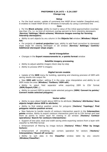
PHOTOMOD 5.24.1472 — 5.24.1507<br />
Change Log<br />
Setup<br />
For the local <strong>version</strong>: update of command line HASP driver installer (haspdinst.exe).<br />
It enables to install HASP driver in Windows 8 manually by using a command line<br />
Core<br />
For the Block scheme: ability to insert a value of the initial approximation (overlap)<br />
less than 1%, i.e. no limit of minimum overlap percent to form interstrip stereopairs<br />
(Service/ Settings/ Block scheme/ Minimum images overlap for forming<br />
interstrip stereopairs)<br />
Ability to sort objects by any column in the Objects list window (Window/ Object<br />
list)<br />
For projects of central projection type: ability to add fixed correction to stereopair<br />
slope angle for viewing stereopair in 2D window (Service/ Settings/ Control/<br />
Additional stereopair slope angle)<br />
Aerial triangulation<br />
Changes in the Export measurements to .x-points format window<br />
Satellite imagery processing<br />
Ability to adjust satellite imagery block step-by-step<br />
Ability to process SPOT 6 imagery<br />
Digital terrain models<br />
Update of the DEM menu for building, operating and checking precision of DEM with<br />
saving results into output file<br />
New DEM edit toolbar: setting Z in the area, area interpolation and ability to cut<br />
DEM inside the area (Window/ Toolbars/ DEM edit)<br />
Ability to select field separator while exporting DEM to CSV format<br />
(DEM/Export/CSV...)<br />
Ability to convert DEM to points inside selected polygons (DEM/ Convert to points/<br />
Convert inside selected polygons)<br />
Vector editor<br />
Ability to save object height above DEM to its attribute (Vectors/ Attributes/ Save<br />
objects height above DEM to attribute)<br />
Ability to find relative position errors for polygons (Vectors/ Topo<strong>log</strong>y/ Find<br />
polygons relative position errors)<br />
New features to handle results of contours intersection search in the Intersection<br />
points window. Ability to export contours intersection point list to CSV format and load<br />
them as points to vector layer for viewing in 2D window (Vectors/ Contour<br />
operations/ Search for contours intersections)<br />
Support of line color, style and width saving while exporting vectors from a layer with<br />
classifier to MIF/MID format<br />
Enhancement of filtering by image texture (Vectors/ Filter/ Filter by image<br />
texture)<br />
Enhancement of smoothing out corners operation for vectors (Vectors/<br />
Interpolation/ Round off corners)<br />
Ability to sort data in the Classifier window table by any column<br />
(Window/Classifier)
Raster operations<br />
New QuickLook and External image modes in the Autolevels window for<br />
correction of satellite imagery in the Radiometric correction window<br />
New QuickLook mode in the Autolevels window for correction of satellite imagery<br />
in ImageWizard<br />
PHOTOMOD GeoMosaic<br />
Optimization of image selection while manual drawing a cutline in the Transparent<br />
with reference image mode in the Preview window<br />
New Date/Time (date/time of the survey) column with ability to sort images in<br />
descending order in the Project images list window (Images/ Project images list)<br />
New Off nadir angle (off nadir angle of the survey) column with ability to sort<br />
images in ascending order in the Project images list window (Images/ Project<br />
images list)<br />
Distributed processing<br />
Ability to merge DEMs in distributed processing mode<br />
Speeding up the following operations in distributed processing mode: restoring NULL<br />
cells while creating dense DTM, transforming DEM to another coordinate system,<br />
merging DEMs, transforming DEM to PHOTOMOD MegaTIFF format in Mosaic and<br />
Geomosaic modules<br />
3D-Mod<br />
Ability of snapping to points in the Edit texture coordinates window (by keeping<br />
hot keys B or V)<br />
Ability to export results to SHAPE format (.shp)<br />
Ability to export “walls”