

Storm Data and Unusual Weather Phenomena - CIG - Mesonet
Storm Data and Unusual Weather Phenomena - CIG - Mesonet
Storm Data and Unusual Weather Phenomena - CIG - Mesonet

Create successful ePaper yourself
Turn your PDF publications into a flip-book with our unique Google optimized e-Paper software.
DECEMBER 1999<br />
VOLUME 41<br />
NUMBER 12<br />
STORM<br />
DATA<br />
AND UNUSUAL WEATHER PHENOMENA<br />
WITH LATE REPORTS AND CORRECTIONS<br />
noaa<br />
NATIONAL OCEANIC AND NATIONAL ENVIRONMENTAL SATELLITE, NATIONAL CLIMATIC DATA CENTER<br />
ATMOSPHERIC ADMINISTRATION DATA AND INFORMATION SERVICE ASHEVILLE, NC
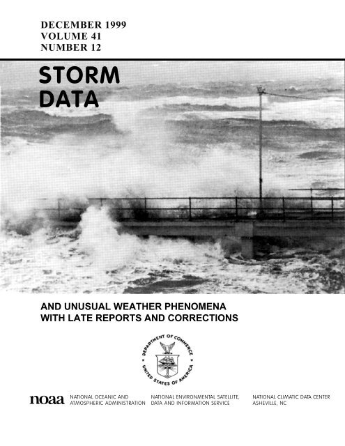
Cover: For the last cover picture of the millenium, the editors selected out first cover photo, which appeared in the August<br />
1983 issue. The caption reads: “Waves from Hurricane Alecia crashing over a fishing pier on Galveston Isl<strong>and</strong>, TX, on<br />
August 17 th , 1983.” (Photograph courtesy of Barbara White <strong>and</strong> Al Wooten)<br />
TABLE OF CONTENTS<br />
Page<br />
Outst<strong>and</strong>ing <strong>Storm</strong>s of the Month ……………………………………………………………………………………….. 4<br />
<strong>Storm</strong> <strong>Data</strong> <strong>and</strong> <strong>Unusual</strong> <strong>Weather</strong> <strong>Phenomena</strong> ………………………………………………………………………….. 5<br />
Additions/ Corrections .…………………………………………………………………………………………………… 82<br />
Reference Notes ..…………………………………………………………………………………………………………. 97<br />
STORM DATA<br />
(ISSN 0039-1972)<br />
National Climatic <strong>Data</strong> Center<br />
Editor: Stephen Del Greco<br />
Assistant Editor: Stuart Hinson<br />
STORM DATA is prepared, funded, <strong>and</strong> distributed by the National Oceanic <strong>and</strong> Atmospheric Administration (NOAA). The<br />
Outst<strong>and</strong>ing <strong>Storm</strong>s of the Month section is prepared by the <strong>Data</strong> Operations Branch of the National Climatic <strong>Data</strong> Center.<br />
The <strong>Storm</strong> <strong>Data</strong> <strong>and</strong> <strong>Unusual</strong> <strong>Weather</strong> <strong>Phenomena</strong> narratives <strong>and</strong> Hurricane/Tropical <strong>Storm</strong> summaries are prepared by the<br />
National <strong>Weather</strong> Service. Monthly <strong>and</strong> annual statistics <strong>and</strong> summaries of tornado <strong>and</strong> lightning events resulting in deaths,<br />
injuries, <strong>and</strong> damage are compiled by cooperative efforts between the National Climatic <strong>Data</strong> Center <strong>and</strong> the <strong>Storm</strong> Prediction<br />
Center.<br />
STORM DATA contains all confirmed information on storms available to our staff at the time of publication. However, due to<br />
difficulties inherent in the collection of this type of data, it is not all-inclusive. Late reports <strong>and</strong> corrections are printed in each<br />
edition.<br />
Maps of the National <strong>Weather</strong> Service County Warning Areas which are used in the <strong>Storm</strong> <strong>Data</strong> <strong>and</strong> <strong>Unusual</strong> <strong>Weather</strong><br />
<strong>Phenomena</strong> section will be printed in all editions.<br />
Except for limited editing to correct grammatical errors, materials submitted are generally published as received.<br />
Note: "None Reported" means that no severe weather occurred <strong>and</strong> "Not Received" means that no reports were received for this<br />
region at the time of printing.<br />
Subscription, pricing, <strong>and</strong> ordering information is available from:<br />
National Climatic <strong>Data</strong> Center<br />
151 Patton Avenue<br />
Asheville, NC 28801<br />
(828)271-4800 or (828) CLIMATE<br />
The editors of STORM DATA solicits your help in acquiring photographs (prints or slides; black <strong>and</strong> white, or color), maps,<br />
clippings, etc. of significant or unusual weather events (past or present). These could be for use in the "Outst<strong>and</strong>ing <strong>Storm</strong>s of<br />
the Month'' section of STORM DATA. We request our subscribers or other interested persons to mail such items to:<br />
Editor - <strong>Storm</strong> <strong>Data</strong><br />
National Climatic <strong>Data</strong> Center<br />
151 Patton Avenue<br />
Asheville, NC 28801<br />
Any such items received by the editor will be for use in STORM DATA only. Any other use will be with the permission of<br />
the owner of said items. Materials submitted will be returned if requested in the original submission.<br />
"I certify that this is an official publication of the National Oceanic <strong>and</strong> Atmospheric Administration <strong>and</strong> is compiled from<br />
information received at the National Climatic <strong>Data</strong> Center Asheville, North Carolina 28801-2733."<br />
2<br />
Thomas R. Karl<br />
Director,<br />
National Climatic <strong>Data</strong> Center
�<br />
'HFHPEHU &RQILUPHG 7RUQDGRHV<br />
� ����� �� �� �� �� �� �� �����<br />
������ � � � � � � ��<br />
� �����<br />
��<br />
��<br />
��<br />
��<br />
��<br />
��
Outst<strong>and</strong>ing <strong>Storm</strong>s of the Month<br />
No “Outst<strong>and</strong>ing <strong>Storm</strong> of the Month” was submitted for December 1999.<br />
4
ALABAMA, North Central<br />
Franklin County<br />
Red Bay 09 2155CST<br />
0 0 0 0<br />
Dime size hail was reported near Red Bay.<br />
Colbert County<br />
Hail (0.75)<br />
7.4 W Crooked Oak 09 2212CST<br />
0 0 0 0 Hail (0.75)<br />
Dime size hail was reported on SR 247 about 3 miles inside the Franklin/Colbert County line by the 247 Volunteer Fire Department.<br />
Winston County<br />
Haleyville 09 2240CST<br />
0 0 3K 0 Thunderstorm Wind (G50)<br />
Several trees were blown down onto roadways around Haleyville. One outbuilding was destroyed on CR 23.<br />
ALZ001>007-<br />
009>017<br />
ALZ006 Madison<br />
ALZ006 Madison<br />
ALABAMA, Southeast<br />
ALABAMA, Southwest<br />
Lauderdale - Colbert - Franklin - Lawrence - Limestone - Madison - Morgan - Jackson - Dekalb -<br />
Marion - Lamar - Fayette - Winston - Walker - Cullman - Blount<br />
21 0400CST<br />
1030CST<br />
0 0 0 0 Ice <strong>Storm</strong><br />
A light mixture of rain, freezing rain, sleet, <strong>and</strong> snow flurries fell across northern Alabama. Numerous trees across the area picked up<br />
a coating of ice, but it melted away by late morning. No significant accumulations were reported. Roadways became briefly slick in<br />
the early morning hours, but no significant icing problems occurred <strong>and</strong> no weather related accidents were reported.<br />
31 2359CST<br />
0 0 0 0 Excessive Heat<br />
The average temperature was 62.60 degrees at the Huntsville International Airport for 1999. This was the 2nd warmest temperature<br />
ever measured since records began in 1958.<br />
31 2359CST<br />
0 0 0 0 Drought<br />
The yearly rainfall measured at the Huntsville International Airport was 45.58 inches. This was the 4th lowest yearly rainfall ever<br />
recorded since records began in 1958.<br />
NONE REPORTED.<br />
NONE REPORTED.<br />
ALASKA, Northern<br />
AKZ007 Tanana Valley<br />
01 0000AST<br />
1100AST<br />
0 0<br />
High Wind (G39)<br />
Deep low pressure in the Gulf of Alaska moving northeast <strong>and</strong> weak high pressure over the NW Yukon Territory resulted in a<br />
tightening pressure gradient over the upper Tanana Valley, producing strong east winds at Delta Junction. The Delta Junction ASOS<br />
reported gusts as high as 45 mph.<br />
AKZ003-009 Lower Kobuk Valley-Northern Seward Peninsula - St. Lawrence Isl<strong>and</strong>-Bering Strait Coast<br />
02 1535AST<br />
0 0<br />
High Wind (G53)<br />
03 1400AST<br />
Large Arctic High over the NW Arctic coast was stationary while a Low pressure center developed over the Seward Peninsula<br />
creating local strong winds at:<br />
Saint Lawrence Isl<strong>and</strong>: Gambell AWOS highest gust 52 mph.<br />
Lower Kobuk Valley to Cape Lisburne: Point Hope AWOS highest gust 61 mph.<br />
AKZ001 Arctic Slope Coastal<br />
AKZ007 Tanana Valley<br />
<strong>Storm</strong> <strong>Data</strong> <strong>and</strong> <strong>Unusual</strong> <strong>Weather</strong> <strong>Phenomena</strong><br />
Time<br />
Path Path<br />
Number of<br />
Estimated<br />
Local/ Length Width<br />
Persons<br />
Damage<br />
Location Date St<strong>and</strong>ard (Miles) (Yards) Killed Injured Property Crops Character of <strong>Storm</strong><br />
18 2315AST<br />
0 0<br />
Extreme Windchill<br />
20 0000AST<br />
With a cold airmass in place over the North Slope, a low pressure center moved north over the west coast of Alaska producing<br />
extreme wind chill conditions at Point Lay. Lowest reported wind chill at Point Lay was -96. Wind speed was 25 mph.<br />
19 0000AST<br />
0600AST<br />
0 0<br />
High Wind (G44)<br />
An occluded front moving north over the Gulf of Alaska strengthened the pressure gradient across the upper Tanana Valley,<br />
producing strong east winds at Delta Junction. Delta Junction ASOS reported a peak gust of 51 mph.<br />
15<br />
December 1999
ALASKA, Northern<br />
AKZ004>005- Koyukuk-Upper Kobuk Valleys - Upper Yukon Valley - Tanana Valley - Lower Yukon Valley<br />
007>008<br />
20<br />
23<br />
21<br />
23<br />
0900AST<br />
1700AST<br />
AKZ007 Tanana Valley<br />
0600AST<br />
0500AST<br />
AKZ007 Tanana Valley<br />
0<br />
0<br />
0<br />
0<br />
Heavy Snow<br />
Ice <strong>Storm</strong><br />
21 2100AST<br />
0 0 25K<br />
High Wind (G52)<br />
22 1000AST<br />
A strong Low in the North Pacific moved north over the Alaska Peninsula on the evening of the 21st, then northeast over the interior<br />
of Alaska on the 22nd, with a second low developing just beyond the northeast corner of Alaska on the afternoon of the 22nd. The<br />
main low over the central interior also moved northeast joining the second low early on the 23rd, with a cold front sweeping east<br />
across the interior the night of the 22nd <strong>and</strong> stalling over the eastern Tanana Valley early on the 23rd, then moving east into Canada<br />
late in the day. The storm system brought a variety of winter weather to interior Alaska, along with High winds near the Alaska<br />
Range. Behind the cold front, moderate west winds over the eastern Tanana Valley existed from 9am on the 23rd to 9am on the 24th,<br />
hampering snow <strong>and</strong> ice removal in the Tok area.<br />
SNOW amounts reported:<br />
ZONE 5: Upper Yukon Valley: Ch<strong>and</strong>alar Lake #2 23rd 7.5 inches; Circle Hot Springs 21st-22nd 8.4 inches; Wiseman 21st-22nd<br />
13.2 inches; Ch<strong>and</strong>alar lake 22nd 7.0 inches; 7 mile D.O.T 22nd 8.0 inches; Chicken 21st 9.0 inches; Eagle 21st 7.0 inches<br />
ZONE 4: Koyukuk Valley: Coldfoot D.O.T. 23rd-24th 17.0 inches; Ch<strong>and</strong>alar Shelf D.O.T. 23rd 14.0 inches.<br />
ZONE 8: Lower Yukon Valley: Galena 22nd 7.0 inches.<br />
ZONE 7: Tanana Valley: Lake Minchumina 21st-22nd 15.5 inches; Tok D.O.T. 21st-24th 20.0 inches; Robertson River 21st 17.9<br />
inches; Tanacross 21st 10.0 inches; Dry Creek 21st 14.5 inches; Northway D.O.T. 21st 6.0 inches. The State of Alaska<br />
Department of Transportation at Delta Junction reported unofficially that 34 inches had fallen by 9pm on the 21st at Trimms Camp<br />
south of Delta Junction on the Richardson Highway (in the Alaska Range).<br />
FREEZING RAIN reported across the Tanana Valley: Ester 5NE 21st 9pm; Fox 21st-22nd; Ester Dome 21st; Chena Ridge 21st ;<br />
North Pole(KJNP Radio) 21st; Fairbanks midtown 22nd-23rd; Goldstream22nd freezing drizzle; Eureka 23rd. The State of Alaska<br />
Department of Transportation at Delta Junction closed the Richardson Highway due to strong winds <strong>and</strong> heavy rains freezing on the<br />
roads. Roadside ditches were full <strong>and</strong> water was running down the highways. Creeks along the Richardson were overflowing <strong>and</strong><br />
running across the road. Cold ground conditions caused the water to freeze on the road accumulating up to 4 inches of ice on the<br />
roadway. D.O.T. snow/plow trucks were blown off the road as a result of the high winds. Two private vehicles were str<strong>and</strong>ed<br />
overnight in the Trimms Areas (south of Delta Junction in the Alaska Range) because neither Delta nor Paxson road crews could<br />
reach them. The D.O.T. office at Tok reported extremely hazardous driving conditions continuing onthe 23rd as an additional six<br />
inches of snow fell on the ice layer.<br />
HIGH WIND, Tanana Valley: Highest gusts: Denali Park AWOS 47 mph; Healy 60 mph; Delta Junction ASOS 48 mph - ASOS was<br />
without power during the middle of this event, so highest gust noted above was from available data before <strong>and</strong> after power outage..<br />
See above narrative on Freezing Rain in the Delta Junction/northern Richardson Highway area. The State of Alaska Department of<br />
Transportation at Delta Junction estimated winds as high as 60 mph sustained with gusts to 85 mph; trees <strong>and</strong> signs were blown<br />
down.<br />
AKZ002-004>005 North Slopes Of Brooks Range - Koyukuk-Upper Kobuk Valleys - Upper Yukon Valley<br />
AKZ007 Tanana Valley<br />
AKZ007 Tanana Valley<br />
<strong>Storm</strong> <strong>Data</strong> <strong>and</strong> <strong>Unusual</strong> <strong>Weather</strong> <strong>Phenomena</strong><br />
Time<br />
Path Path<br />
Number of<br />
Estimated<br />
Local/ Length Width<br />
Persons<br />
Damage<br />
Location Date St<strong>and</strong>ard (Miles) (Yards) Killed Injured Property Crops Character of <strong>Storm</strong><br />
24 2200AST<br />
0 0<br />
Extreme Windchill<br />
25 0235AST<br />
Building high pressure over interior Alaska with a cold airmass over the Brooks Range <strong>and</strong> North Slope created a period of extreme<br />
windchills on the north <strong>and</strong> south slopes of the Brooks Range, inferred from observations at Anaktuvuk Pass, where the lowest<br />
windchill value was -80.<br />
25 0600AST<br />
0 0<br />
High Wind (G50)<br />
1500AST<br />
Strong high pressure was stationary over eastern Canada while a low pressure center at mid-levels of the atmosphere moved<br />
north-northeast over the western Alaska Range, the western Tanana Valley, <strong>and</strong> to Fort Yukon in the Upper Yukon Valley before<br />
dissipating. This created strong east winds at Delta Junction, where the highest winds reported by the ASOS were 39 mph sustained<br />
<strong>and</strong> gust to 58 mph.<br />
26 1535AST<br />
0 0<br />
High Wind (G46)<br />
27 1000AST<br />
The occlusion from a strong low moving north over the Alaska Peninsula moved over the western Alaska Range <strong>and</strong> before<br />
26<br />
December 1999
ALASKA, Northern dissipating brought strong south winds near Alaska Range Passes. Highest winds reported were:<br />
AKZ001 Arctic Slope Coastal<br />
Healy gust to 53 mph; Delta Junction ASOS gust to 50 mph.<br />
28<br />
29<br />
29<br />
31<br />
2124AST<br />
1300AST<br />
AKZ001 Arctic Slope Coastal<br />
0615AST<br />
1400AST<br />
AKZ001 Arctic Slope Coastal<br />
<strong>Storm</strong> <strong>Data</strong> <strong>and</strong> <strong>Unusual</strong> <strong>Weather</strong> <strong>Phenomena</strong><br />
Time<br />
Path Path<br />
Number of<br />
Estimated<br />
Local/ Length Width<br />
Persons<br />
Damage<br />
Location Date St<strong>and</strong>ard (Miles) (Yards) Killed Injured Property Crops Character of <strong>Storm</strong><br />
0<br />
0<br />
0<br />
0<br />
Extreme Windchill<br />
High Wind (G68)<br />
29 1100AST<br />
0 0<br />
Blizzard<br />
31 2359AST<br />
Large low pressure 600 miles northeast of Prudhoe Bay drifted southwest to 450 miles northeast of Prudhoe Bay with a weather front<br />
moving southeast over the Beaufort Sea. Strong high pressure remaining over Russia Far East created strong winds <strong>and</strong> blizzard<br />
conditions over the eastern Arctic Coast, along with low wind chills initially. Event continued into January 2000.<br />
Blizzard conditions occurred at: Deadhorse, Barter Isl<strong>and</strong>, Kuparuk.<br />
High wind occurred at Barter Isl<strong>and</strong>: 67 mph sustained, gust to 78 mph.<br />
Lowest Wind Chill reported: Barter Isl<strong>and</strong> -88; Deadhorse -90; Nuiqsut -87.<br />
ALASKA, Southeast<br />
AKZ024 Lynn Canal-Glacier Bay<br />
06 1700AST<br />
2300AST<br />
The haines areas received 2 feet of snow.<br />
AKZ027 Southern Southeast Alaska Ernest Sound To Dixon Entrance<br />
08<br />
0300AST<br />
0900AST<br />
AKZ028 Dixon Entrance To Cape Decision-Coastal Area<br />
08 0300AST<br />
0900AST<br />
Peak winds at several locations were 45 kt.<br />
AKZ022 Cape Fairweather To Cape Suckling-Coastal Area<br />
0<br />
0<br />
0<br />
0<br />
0<br />
0<br />
Heavy Snow<br />
High Wind (G45)<br />
High Wind (G45)<br />
08 0800AST<br />
1400AST<br />
0 0<br />
Heavy Snow<br />
Heavy snow warning for Zone 22 West of Yakutat. Satellite data indicated heavy snow showers were over coastal areas where no<br />
surface observations were available.<br />
AKZ022 Cape Fairweather To Cape Suckling-Coastal Area<br />
11 1530AST<br />
0 0<br />
Heavy Snow<br />
12 0845AST<br />
Snowfall at Yakutat was 13.2 inches for a 48 hour period. Unknown how much accumulated in any period because the snow was<br />
occasionally mixed with rain.<br />
AKZ027>028 Southern Southeast Alaska Ernest Sound To Dixon Entrance - Dixon Entrance To Cape Decision-<br />
Coastal Area<br />
13<br />
1000AST<br />
2130AST<br />
AKZ022 Cape Fairweather To Cape Suckling-Coastal Area<br />
14 0600AST<br />
2130AST<br />
0<br />
Numerous heavy snow showers produced 13 inches at Yakutat.<br />
AKZ022 Cape Fairweather To Cape Suckling-Coastal Area<br />
17 1000AST<br />
1600AST<br />
Yakutat received 10.2 inches of snow in 6 hours.<br />
18 1600AST<br />
0<br />
19 0600AST<br />
Yakutat received 21 inches of snow in about 30 hours.<br />
0<br />
0<br />
0<br />
0<br />
0<br />
0<br />
Heavy Snow<br />
Heavy Snow<br />
Heavy Snow<br />
AKZ022-025 Cape Fairweather To Cape Suckling-Coastal Area - Juneau Borough-Admiralty Isl<strong>and</strong>-Icy Strait<br />
Area<br />
37<br />
Heavy Snow<br />
December 1999
ALASKA, Southeast<br />
AKZ025 Juneau Borough-Admiralty Isl<strong>and</strong>-Icy Strait Area<br />
ALASKA, Southern<br />
AKZ017 Central Gulf Coast<br />
27 0100AST<br />
0 0<br />
Flood<br />
28 1500AST<br />
Aslow moving tropical connection frontal boundry spread 3 to 5 inches of rain over the Northern Panh<strong>and</strong>le. Minor small stream<br />
flooding of Jordan Creek in the Juneau airport area flooded two homes <strong>and</strong> one business. The Skagway <strong>and</strong> Taiya Rivers near<br />
Skagway were bank full but no flooding was reported.<br />
01 0000AST<br />
0400AST<br />
0 0<br />
High Wind (G54)<br />
A moderate front, associated with a strong 958 mb low 120 miles south of Middleton Isl<strong>and</strong>, was preceded by brisk east winds across<br />
much of the Gulf of Alaska waters immediately adjacent to the Alaskan coast. Wind gusts reached 62 mph at Middleton Isl<strong>and</strong> very<br />
early Wednesday. The front moved inl<strong>and</strong> <strong>and</strong> the low weakened significantly as the day progressed Wednesday.<br />
AKZ015-018 Cook Inlet - Kodiak Isl<strong>and</strong>-Eastern Alaska Peninsula<br />
AKZ020 Aleutian Isl<strong>and</strong>s<br />
AKZ017 Central Gulf Coast<br />
AKZ020 Aleutian Isl<strong>and</strong>s<br />
06 1200AST<br />
0 0<br />
High Wind (G56)<br />
2359AST<br />
Strong westerly winds, on the back side of a weakening low near Middleton Isl<strong>and</strong>, were reported through the Barren Isl<strong>and</strong>s<br />
(northeast of Kodiak Isl<strong>and</strong>) <strong>and</strong> in the lower part of Cook Inlet. Gusts reached close to 60 mph at the Augustine Isl<strong>and</strong> site in lower<br />
Cook Inlet. Westerly winds of 65 mph were reported by the M/V "Seal<strong>and</strong> Tacoma", east southeast of the Barren Isl<strong>and</strong>s, late<br />
Monday.<br />
07 1200AST<br />
0 0<br />
High Wind (G62)<br />
08 0900AST<br />
A strong front elongated eastward through the Aleutians <strong>and</strong> extreme southern Bering Sea Tuesday afternoon through Wednesday.<br />
As the front elongated east, it weakened. Initially, strong southeast winds to 71 mph were reported around Shemya (extreme western<br />
Aleutians) late Tuesday afternoon <strong>and</strong> Tuesday night. Winds were not quite as strong across the eastern Aleutians in advance of the<br />
front.<br />
08 0600AST<br />
2300AST<br />
0 0<br />
Heavy Snow<br />
11 inches of new snow was recorded at the DOT site just east of the town of Cordova. Most of the snow fell in 12 hours between<br />
9am <strong>and</strong> 9pm Wednesday.<br />
08<br />
09<br />
1800AST<br />
1500AST<br />
AKZ019-021 Western Alaska Peninsula - Pribilof Isl<strong>and</strong>s<br />
AKZ011>013-<br />
015>016<br />
0<br />
0<br />
High Wind (G75)<br />
10 1200AST<br />
0 0<br />
Blizzard<br />
11 0900AST<br />
Strong northwesterly winds to 60 mph were observed along the western Aleutians late Wednesday <strong>and</strong> Thursday. A strong 966 mb<br />
low, just south of Attu late Wednesday afternoon, moved east southeast then dissipated Thursday morning. A second center formed<br />
in the south central Bering Sea early Thursday, curving south southeast by Adak Thursday morning. As the low passed, brisk<br />
westerly winds on the back side of the storm moved into Adak, where gusts reached close to 60 mph in the mid afternoon. Williwas<br />
moving down from Mount Ballyhoo produced wind gusts of 86 mph at the Dutch Harbor Spit Friday between 7 pm <strong>and</strong> 8 pm.<br />
Blizzard conditions developed across the Pribilofs <strong>and</strong> the western Alaska Peninsula Friday <strong>and</strong> Saturday. Northwest wind gusts<br />
from 35 to near 50 mph dropped visibilities to 1/4 mile in blowing snow.<br />
Kuskokwim Delta - Kuskokwim Valley - Susitna Valley - Cook Inlet - Bristol Bay Coastal<br />
10<br />
12<br />
0000AST<br />
2300AST<br />
AKZ017 Central Gulf Coast<br />
<strong>Storm</strong> <strong>Data</strong> <strong>and</strong> <strong>Unusual</strong> <strong>Weather</strong> <strong>Phenomena</strong><br />
Time<br />
Path Path<br />
Number of<br />
Estimated<br />
Local/ Length Width<br />
Persons<br />
Damage<br />
Location Date St<strong>and</strong>ard (Miles) (Yards) Killed Injured Property Crops Character of <strong>Storm</strong><br />
0<br />
0<br />
Extreme Windchill<br />
12 0000AST<br />
2300AST<br />
0 0<br />
High Wind (G55)<br />
Brisk northerly winds brought wind chills down to 65 below across many areas of the Kuskokwim Delta <strong>and</strong> Bristol Bay. Local wind<br />
chills to 65 below were also observed along higher terrain of the Kuskokwim Valley.<br />
Brisk northeast winds, gusting to 50 mph locally around Cantwell <strong>and</strong> out of the passes of the western Alaska Range Saturday <strong>and</strong><br />
Sunday, also brought wind chills down as low as 65 below.<br />
48<br />
December 1999
ALASKA, Southern Local winds around Whittier reached 63 mph Sunday evening.<br />
AKZ019 Western Alaska Peninsula<br />
11<br />
12<br />
0000AST<br />
1600AST<br />
AKZ021 Pribilof Isl<strong>and</strong>s<br />
<strong>Storm</strong> <strong>Data</strong> <strong>and</strong> <strong>Unusual</strong> <strong>Weather</strong> <strong>Phenomena</strong><br />
Time<br />
Path Path<br />
Number of<br />
Estimated<br />
Local/ Length Width<br />
Persons<br />
Damage<br />
Location Date St<strong>and</strong>ard (Miles) (Yards) Killed Injured Property Crops Character of <strong>Storm</strong><br />
0<br />
0<br />
Blizzard<br />
11 0000AST<br />
0 0<br />
Heavy Snow<br />
12 0900AST<br />
An "arctic type" low moved southward through the eastern Bering Sea to a position between Saint Paul Isl<strong>and</strong> <strong>and</strong> Unalaska<br />
mid-afternoon Saturday as an innocuous 1014 mb center. As the system turned southeast into the 'relatively milder' waters of the<br />
North Pacific, the very cold, unstable air aloft, associated with the low, triggered rapid deepening. By 3pm Sunday the low was an<br />
intense 986 mb storm 300 miles south of Cordova.<br />
Heavy snows were observed across the Pribilofs <strong>and</strong> Alaska Peninsula as the low passed...with snowfall amounts ranging from 6 to<br />
12 inches in less than 24 hours. Brisk north <strong>and</strong> northwest winds on the back side of the low caused blizzard conditions in blowing<br />
snow along the Alaska Peninsula from Saturday afternoon through Sunday afternoon.<br />
AKZ017>018-020 Central Gulf Coast - Kodiak Isl<strong>and</strong>-Eastern Alaska Peninsula - Aleutian Isl<strong>and</strong>s<br />
18<br />
19<br />
0000AST<br />
2359AST<br />
AKZ011-019-021 Kuskokwim Delta - Western Alaska Peninsula - Pribilof Isl<strong>and</strong>s<br />
0<br />
0<br />
High Wind (G66)<br />
18 1200AST<br />
0 0<br />
Blizzard<br />
20 2359AST<br />
An intense 963 mb low in the north-central Pacific moved into Bristol Bay early Sunday, weakening to a 980 mb center. By 9 am<br />
Monday, the low had weakened to a 994 mb center just west of Kotzebue Sound. Brisk north winds along the west side of the low<br />
were observed from the Pribilofs into the eastern Aleutians. Gusts reached 67 mph at Dutch Harbor Saturday.<br />
Strong easterly winds were observed ahead of the front associated with this low. By Saturday evening, the front had moved northeast<br />
into the Gulf of Alaska...on its way inl<strong>and</strong> toward the Alaska Range early Sunday. Gusts reached 76 mph at Middleton Isl<strong>and</strong> in<br />
advance of the front, diminishing rapidly around 3 am Sunday as the front moved by the Isl<strong>and</strong>. Gusts reached 53 mph late Saturday,<br />
<strong>and</strong> 64 mph Sunday, around Cordova. Strongest winds around Cordova occurred with the frontal passage.<br />
Across the Kuskokwim Delta, blizzard conditions developed Saturday, continuing into Sunday. Wind chills reached 50 below around<br />
Bethel Monday with winds still gusting to 40 mph.<br />
Blizzard conditions were also reported across the Pribilofs from Saturday through early Monday.<br />
Strong northerly winds were also reported along the Alaska Peninsula, accompanied by local blizzard conditions in blowing snow<br />
Monday.<br />
AKZ014>015-017 Copper River Basin - Cook Inlet - Central Gulf Coast<br />
21<br />
22<br />
0000AST<br />
2359AST<br />
AKZ015-017 Cook Inlet - Central Gulf Coast<br />
0<br />
0<br />
75K<br />
High Wind (G130)<br />
21 0000AST<br />
2359AST<br />
0 0 200K<br />
Heavy Snow<br />
Strong southeasterly winds blew across the Gulf of Alaska Tuesday <strong>and</strong> Wednesday ahead of a moderate front. While wind gusts<br />
were generally 40 to 60 mph ahead of the front, reports of stronger winds were received. Prior to the onset of strong winds, many<br />
areas adjacent to Prince William Sound <strong>and</strong> across Southcentral Alaska received a heavy dump of snow.<br />
Notably, in the city of Cordova, east southeast winds reached sustained values of 104 mph with gusts reaching an incredible 150<br />
mph. This report came from a pilot on the ground in downtown Cordova by the Coast Guard. Additionally , there were unconfirmed<br />
reports the following day of water from Eyak Lake onto the runway (which is adjacent to the Lake). Two vessels broke loose from<br />
their moorings in the Cordova harbor, ending up on the breakwater as wind gusts over 120 mph buffetted the area. Fortunately, the<br />
hulls suffered only minor damage. At least two roofs were blown off buildings. Numerous trees fell on streets <strong>and</strong> houses. A heavy<br />
mix of rain <strong>and</strong> snow clogged storm drains <strong>and</strong> flooded some basements. Reports from Cordova Electric Cooperative Tuesday<br />
afternoon measured rainfall of 5.56 inches in 24 hours!<br />
Avalanches temporarily blocked the Richardson Highway near Thompson Pass <strong>and</strong> were also blamed for a fiber-optic cable cut that<br />
interrupted telephone service to Fairbanks. Heavy snow was also reported in Thompson Pass with 28+ inches received from 7 am<br />
Monday to 7 am Tuesday. Two boats sunk in the Valdez Small Boat Harbor.<br />
Heavy snow was also reported around the Kenai Peninsula, with 10 to 14 inches recorded Monday.<br />
59<br />
December 1999
ALASKA, Southern Heavy snow preceded strong winds around Anchorage. 14.9 inches of snow fell in the city between 9 am Monday <strong>and</strong> 9 am Tuesday.<br />
Strong southeasterly winds then followed...especially along the Anchorage hillside. Gusts of 73 mph were recorded at the Rabbit<br />
Creek Forest Service site at 6pm Tuesday, followed an hour later by temperatures reaching a balmy 48 F. Winds at the site peaked at<br />
75 mph early Wednesday (3 am - 4 am).<br />
Other peak winds in the area were:<br />
113 mph in Bear Valley<br />
96 mph between 10pm Tuesday <strong>and</strong> 7am Wednesday - Mid hillside (O'Malley <strong>and</strong> Maintree)<br />
91 mph prior to 7am Wednesday at Glen Alps<br />
79 mph between 2am <strong>and</strong> 3am Wednesday at a mesonet site along Muldoon Road<br />
75 mph at 4:43 am Wednesday at the National Guard site along the Glenn Highway<br />
67 mph at Portage at 4:30 am Wednesday<br />
AKZ011-013-<br />
015>017<br />
Further north, wind gusts of 59 mph were recorded at Palmer at 9:24 pm Tuesday <strong>and</strong> at the Wasilla Fire Station between 3 am <strong>and</strong> 4<br />
am Wednesday.<br />
Temperatures across much of the Anchorage/Palmer area "skyrocketed into the 40s <strong>and</strong> 50s" on Wednesday, as reported by the<br />
Anchorage Daily News. Reports of slick roads, local flooding due to ponding of water over ice, power outages <strong>and</strong> even "bare<br />
enough ground to mow the lawn" were received. Nearly 300 vehicles ended up as '"ditch-divers" on Tuesday around the Anchorage<br />
area. At one point, thous<strong>and</strong>s of homes in the Matanuska Valley were without power. On Wednesday, the Palmer Golf Course was<br />
opened 10 am to 3 pm...<strong>and</strong> best of all, it was free!<br />
Winds also reached high speeds in the Copper River Basin <strong>and</strong> were accompanied by locally heavy rains (a very unusual event at this<br />
time of year!). Gusts above 40 mph began at 3 pm at the Gulkana observation site, peaking at 63 mph between 6 <strong>and</strong> 7 pm Tuesday.<br />
Strong gusts continued through midnight. Gusts reached 55 mph at the Eureka AWOS, located along the western extent of the<br />
Copper River Basin. Wind gusts reached 75 mph around Paxson.<br />
Winds gusting as high as 70 mph were reported around th ecommunities of Halibut cove <strong>and</strong> Peterson Bay, where power was<br />
interrupted. 15 to 18 power poles were taken out by falling trees. Damage was said to be 'extreme' even by Homer st<strong>and</strong>ards.<br />
Kuskokwim Delta - Susitna Valley - Cook Inlet - Bristol Bay Coastal - Central Gulf Coast<br />
25<br />
27<br />
25<br />
27<br />
0000AST<br />
0400AST<br />
AKZ019>021 Western Alaska Peninsula - Aleutian Isl<strong>and</strong>s - Pribilof Isl<strong>and</strong>s<br />
26<br />
0000AST<br />
0400AST<br />
AKZ015 Cook Inlet<br />
0000AST<br />
2359AST<br />
AKZ013 Susitna Valley<br />
<strong>Storm</strong> <strong>Data</strong> <strong>and</strong> <strong>Unusual</strong> <strong>Weather</strong> <strong>Phenomena</strong><br />
Time<br />
Path Path<br />
Number of<br />
Estimated<br />
Local/ Length Width<br />
Persons<br />
Damage<br />
Location Date St<strong>and</strong>ard (Miles) (Yards) Killed Injured Property Crops Character of <strong>Storm</strong><br />
0<br />
0<br />
0<br />
0<br />
0<br />
0<br />
Winter <strong>Storm</strong><br />
Blizzard<br />
High Wind (G78)<br />
26<br />
M37OU<br />
0900AST<br />
1500AST<br />
1 0 2K<br />
Avalanche<br />
Blizzard conditions were reported across much of the southwest Alaskan coast, Bristol Bay, the eastern Aleutians <strong>and</strong> Pribilofs<br />
Sunday. Wind gusts reached close to 50 mph in places, with local wind chills to 70 below calculated in the southwest interior. By<br />
Sunday morning, freezing rain was locally reported across the Bristol Bay <strong>and</strong> Kuskokwim Valley zones. Two snow machiners died<br />
in the Kuskokwim Delta on their way to Bethel, where warnings for wind chills to 75 below were in effect.<br />
Rain <strong>and</strong> freezing rain were preceded by locally heavy snows across much of the southern third of the Alaska mainl<strong>and</strong> from Saturday<br />
afternoon through midday Sunday. Another derailment <strong>and</strong> fuel spill was reported north of Talkeetna. An avalanche death was<br />
reported around Hatcher Pass on December 26th.<br />
On Sunday, southeasterly winds again reached 50 to locally 90 mph around Turnagain Arm, the Upper Anchorage Hillside, parts of<br />
the Matanuska-Susitna Valley <strong>and</strong> areas adjacent to Prince William Sound. Fort Richardson reached a balmy 51 F at 2:06 pm<br />
Sunday, with a peak wind of 56 mph occurring at 2:03 pm...just 3 minutes earlier. Wind gusts along the mid Anchorage hillside<br />
reached 74 mph at 4:37 pm Sunday, however further up the mountains, a 90 mph wind gust was recorded in Bear Valley.<br />
Newspaper reports indicated heavy snow took out power to 100 customers in Voznesenka <strong>and</strong> Kachemak Selo, with a small outage<br />
also reported in the east Halibut Cove area. All are areas along the shores of Kachemak Bay.<br />
The warm air that brought record breaking temperatures to a few locations, also caused black ice on secondary roads in much of<br />
Southcentral Alaska. Just prior to the warm temperatures, precipitation... which began as snow...briefly turned to freezing rain, then<br />
10 6<br />
December 1999
ALASKA, Southern all rain. Wind gusts around the Cordova boat harbor again reached 60 to 70 mph Sunday <strong>and</strong> early Monday.<br />
AKZ020 Aleutian Isl<strong>and</strong>s<br />
AMERICAN SAMOA<br />
Tutuila County<br />
Pago Pago 02 1130SST<br />
1600SST<br />
Tutuila County<br />
Countywide 28 1315SST<br />
1455SST<br />
The culprit for the hazardous weather was an intense 964 mb low situated 240 miles south of King Salmon at 9am Sunday...having<br />
moved quickly north toward the State from its postion in the northeast Pacific Saturday <strong>and</strong> Saturday night. The front associated with<br />
this low stretched almost north-south from the Susitna Valley into the eastern Pacific early Sunday morning. By 9pm Sunday, the<br />
low had weakened over 20 millibars to a 986 millibar center just south of Iliamna with the front displaced only about 180 miles<br />
furhter east. Arctic air draped around the low, roughly coinciding with the Alaska Range late Saturday, drifted north into the Tanana<br />
Valley, while re-entering Cook Inlet from the western Alaska Range early Monday.<br />
27 1200AST<br />
0 0<br />
High Wind (G54)<br />
28 1500AST<br />
A strong front, just south of the Aleutians, was preceded by easterly winds close to 60 mph across the central <strong>and</strong> western third of the<br />
Chain. Winds began to diminish as the front began to weaken Tuesday.<br />
ARIZONA, Central <strong>and</strong> Northeast<br />
AZZ015 Western Mogollon Rim<br />
ARIZONA, Northwest<br />
0<br />
0<br />
0<br />
0<br />
Urban/Sml Stream Fld<br />
Urban/Sml Stream Fld<br />
01 0000MST<br />
0 0<br />
Drought<br />
31 2359MST<br />
A record dry spell was set at theFlagstaff airport this fall <strong>and</strong> early winter. There were 99 days without measurable precipitation at<br />
the airport between September 23 <strong>and</strong> January 1, 2000. On September 23, 1.45 inches of rain fell <strong>and</strong> then there was no measurable<br />
precipitation until January 1st when it snowed 1.3 inches (0.21 inch liquid).<br />
NONE REPORTED.<br />
ARIZONA, South<br />
AZZ019-035 Northern Greenlee - Cochise County<br />
ARIZONA, Southwest<br />
03 1000MST<br />
1700MST<br />
0 0 10K<br />
High Wind (G58)<br />
A dry cold front moving across southern Arizona brought gusty winds <strong>and</strong> areas of blowing dust. A peak wind of 58 mph occured at<br />
Douglas. In northern Greenlee county a tree was blowin across Highway 191 blocking traffic just south of Hanagan Meadow.<br />
NONE REPORTED.<br />
ARKANSAS, Central <strong>and</strong> North Central<br />
Scott County<br />
Cauthron 03 0140CST<br />
Logan County<br />
Booneville 03 0200CST<br />
0<br />
Thunderstorm winds knocked down a few trees at Booneville.<br />
Johnson County<br />
Clarksville 03 0215CST<br />
0<br />
Thunderstorm winds downed some trees in Clarksville.<br />
Logan County<br />
Subiaco 03 0235CST<br />
0<br />
Thunderstorm winds blew down a few trees at Subiaco.<br />
Newton County<br />
<strong>Storm</strong> <strong>Data</strong> <strong>and</strong> <strong>Unusual</strong> <strong>Weather</strong> <strong>Phenomena</strong><br />
Time<br />
Path Path<br />
Number of<br />
Estimated<br />
Local/ Length Width<br />
Persons<br />
Damage<br />
Location Date St<strong>and</strong>ard (Miles) (Yards) Killed Injured Property Crops Character of <strong>Storm</strong><br />
5 SW Jasper 03 0245CST<br />
0 0<br />
Thunderstorm winds downed several trees about 5 miles southwest of Jasper.<br />
11 7<br />
0<br />
0<br />
0<br />
0<br />
0<br />
Hail (0.75)<br />
December 1999<br />
Thunderstorm Wind (G50)<br />
Thunderstorm Wind (G50)<br />
Thunderstorm Wind (G50)<br />
Thunderstorm Wind (G50)
ARKANSAS, Central <strong>and</strong> North Central<br />
Polk County<br />
Hatfield 03 0345CST<br />
Polk County<br />
Dallas 03 0445CST<br />
0 0<br />
Thunderstorm winds knocked down some large tree limbs at Dallas.<br />
Polk County<br />
Mena 04 1450CST<br />
1451CST<br />
Clark County<br />
0.5 40 0<br />
0<br />
0<br />
0<br />
Hail (0.75)<br />
Thunderstorm Wind (G50)<br />
Tornado (F0)<br />
A weak tornado was spawned in Mena of Polk County. Mostly minor damage occurred around U.S. Highway 71 <strong>and</strong> Morrow Street,<br />
including some roof damage at a strip shopping center <strong>and</strong> at a couple of restaurants. An industrial plant also suffered some roof<br />
damage, with two empty truck trailers blown over in the parking lot. The tornado was on the ground for a half mile before dissipating.<br />
Hollywood 04 1625CST<br />
0 0<br />
Thunderstorm Wind (G50)<br />
Thunderstorm winds downed some trees around Hollywood on or near state highways 51 <strong>and</strong> 53.<br />
Clark County<br />
Gurdon 04 1625CST<br />
0 0<br />
Thunderstorm winds knocked down a few trees around Gurdon on or near state highway 53.<br />
Hot Spring County<br />
2.1 SE Friendship to 04 1649CST<br />
2.1 NW Donaldson<br />
1658CST<br />
Johnson County<br />
5 NW Clarksville to 04 1710CST<br />
6.8 NNW<br />
Clarksville<br />
1715CST<br />
Hot Spring County<br />
4.3 75 0<br />
0<br />
Thunderstorm Wind (G50)<br />
Tornado (F1)<br />
A weak tornado was spawned in Hot Spring County. The tornado developed around 2 miles southeast of Friendship <strong>and</strong> caused<br />
mostly tree damage. Hundreds of trees were either snapped or twisted. The tornado crossed U.S. Highway 67 at the Ouachita River<br />
bridge <strong>and</strong> destroyed a barn <strong>and</strong> damaged the back porch of a house in the area. The tornado dissipated about 2 miles northwest of<br />
Donaldson.<br />
2.8 50 0<br />
0<br />
Tornado (F1)<br />
A weak tornado was spawned in Johnson County. The tornado developed around 5 miles northwest of Clarksville <strong>and</strong> destroyed a<br />
barn <strong>and</strong> a shed. One house had several pieces of siding removed <strong>and</strong> another house had some roof shingles torn off. Several trees<br />
<strong>and</strong> power lines were also downed before the tornado dissipated about 7 miles north-northwest of Clarksville.<br />
7 NNE Malvern 04 1728CST<br />
0 0<br />
Thunderstorm winds blew down a few trees about 7 miles north-northeast of Malvern.<br />
Yell County<br />
.8 NW Ola to<br />
2 NE Centerville<br />
04 1730CST<br />
Hot Spring County<br />
6 SE Malvern 04 1740CST<br />
Garl<strong>and</strong> County<br />
1 N Mountain Pine 09 1510CST<br />
Garl<strong>and</strong> County<br />
1 W Mountain Pine 09 1510CST<br />
Lincoln County<br />
8.7 75 0<br />
0<br />
Thunderstorm Wind (G50)<br />
Tornado (F1)<br />
A weak tornado was spawned in Yell County. The tornado developed just northwest of Ola <strong>and</strong> damaged a couple of old chicken<br />
houses <strong>and</strong> flattened an old barn. A few houses suffered some roof damage, with damage to a few outbuildings as well. One house<br />
suffered more extensive damage with a broken front porch window, a damaged front porch, <strong>and</strong> several trees blown onto a metal<br />
fence. A few dozen trees, power lines <strong>and</strong> power poles were also downed before the tornado dissipated about 2 miles northeast of<br />
Centerville.<br />
Star City 09 1715CST<br />
0 0<br />
Thunderstorm winds knocked down some power lines at Star City.<br />
ARKANSAS, East<br />
<strong>Storm</strong> <strong>Data</strong> <strong>and</strong> <strong>Unusual</strong> <strong>Weather</strong> <strong>Phenomena</strong><br />
Time<br />
Path Path<br />
Number of<br />
Estimated<br />
Local/ Length Width<br />
Persons<br />
Damage<br />
Location Date St<strong>and</strong>ard (Miles) (Yards) Killed Injured Property Crops Character of <strong>Storm</strong><br />
NONE REPORTED.<br />
12 8<br />
0<br />
0<br />
0<br />
0<br />
0<br />
0<br />
Hail (0.88)<br />
Hail (1.00)<br />
Hail (0.75)<br />
December 1999<br />
Thunderstorm Wind (G50)
ARKANSAS, Northwest<br />
Crawford County<br />
Alma 02 2355CST<br />
Madison County<br />
Huntsville 03 0029CST<br />
0<br />
Thunderstorm winds blew down several large tree limbs.<br />
Madison County<br />
0<br />
0<br />
0<br />
0.10K<br />
Marble 03 0045CST<br />
0 0 10K<br />
One half of the roof of a double-wide trailer was blown off by thunderstorm winds.<br />
Madison County<br />
Pettigrew 03 0045CST<br />
Thunderstorm winds blew large tree limbs down.<br />
Carroll County<br />
Osage 03 0103CST<br />
Thunderstorm winds blew large tree limbs down.<br />
Sebastian County<br />
Ft Smith 03 0118CST<br />
Sebastian County<br />
Ft Smith 03 0120CST<br />
Sebastian County<br />
0<br />
0<br />
0<br />
0<br />
0<br />
0<br />
0<br />
0<br />
0.10K<br />
0.10K<br />
Hail (0.75)<br />
Thunderstorm Wind<br />
Thunderstorm Wind<br />
Thunderstorm Wind<br />
Thunderstorm Wind<br />
Thunderstorm Wind (G52)<br />
Hail (0.88)<br />
Ft Smith 03 0122CST 0.2 75 0 0 5M<br />
Tornado (F1)<br />
A gustnado occurred at 122 am near Phoenix <strong>and</strong> 46th street in Fort Smith <strong>and</strong> was on the ground for approximately 20 seconds. 3<br />
warehouses <strong>and</strong> 2 office buildings were heavily damaged. A motor home,<br />
construction trailer <strong>and</strong> cessna airplane were also destroyed. There was also damage to a hangar at the Fort Smith airport <strong>and</strong> minor<br />
damage was done to 2 commuter planes.<br />
Sebastian County<br />
Ft Smith 03 0127CST<br />
0<br />
Thunderstorm winds blew down numerous power poles.<br />
Crawford County<br />
0<br />
3K<br />
Thunderstorm Wind<br />
Mulberry 03 0140CST<br />
0 0 10K<br />
Thunderstorm Wind<br />
Thunderstorms winds blew several trees down, 9 power poles down, <strong>and</strong> the roof off a barn near Mulberry.<br />
Franklin County<br />
Charleston 03 0140CST<br />
Franklin County<br />
0<br />
0<br />
Hail (0.88)<br />
Ozark 03 0200CST<br />
0 0 1K<br />
Thunderstorm Wind<br />
Thunderstorm winds blew down several large trees between Mulberry in Crawford county <strong>and</strong> Ozark in Franklin county. The report<br />
came from the forrest service.<br />
ARKANSAS, Southeast<br />
ARKANSAS, Southwest<br />
Little River<br />
County<br />
NONE REPORTED.<br />
18 W Ashdown 04 1345CST<br />
0 1 400K<br />
Thunderstorm Wind (G70)<br />
John Moon, who lives near Hwy 108 West of Ashdown, had three chicken houses, one metal building <strong>and</strong> farm equipment destroyed<br />
<strong>and</strong> a fourth house damaged. In addition, he lost 44,000 two day old chicks with an estimated total damage of $350 thous<strong>and</strong> dollars.<br />
Moon was inside one of the chicken houses when the winds struck. A large fan fell on his back causing minor injuries. The winds<br />
also damaged the home of Ashdown Police Sargent Danny Hallet, Hwy 108 west of Ashdown. Windows were broken out on his<br />
patrol car <strong>and</strong> a camper trailer was overturned. Two other homes reported roof damage; several trees were uprooted <strong>and</strong> some<br />
snapped off above the ground accounting for the remainder of monetary loss.<br />
Howard County<br />
<strong>Storm</strong> <strong>Data</strong> <strong>and</strong> <strong>Unusual</strong> <strong>Weather</strong> <strong>Phenomena</strong><br />
Time<br />
Path Path<br />
Number of<br />
Estimated<br />
Local/ Length Width<br />
Persons<br />
Damage<br />
Location Date St<strong>and</strong>ard (Miles) (Yards) Killed Injured Property Crops Character of <strong>Storm</strong><br />
1 W Center Pt to 04 1455CST<br />
6 E Center Pt<br />
1515CST<br />
House destroyed by thunderstorm winds.<br />
13 9<br />
0<br />
0<br />
60K<br />
December 1999<br />
Thunderstorm Wind (G58)
ARKANSAS, Southwest<br />
Howard County<br />
7 W Nashville to 04 1455CST<br />
0 0 48K<br />
3 E Nashville<br />
1515CST<br />
Three barns destroyed <strong>and</strong> minor roof damage to a residence. Numerous power outages<br />
CALIFORNIA, Extreme Southeast<br />
CAZ031 Lower Colorado River Valley<br />
Thunderstorm Wind (G57)<br />
11 0500PST<br />
1600PST<br />
0 1<br />
High Wind (G60)<br />
Strong <strong>and</strong> gusty winds knocked over at least 2 big rigs on Interstate 10,forcing authorities to block off traffic for several hours. A<br />
driver of one truck suffered minor injuries, but was not hospitalized.<br />
CALIFORNIA, North Central<br />
CAZ067-069 Motherlode/Camptonville To Grovel<strong>and</strong> - West Slope Northern Sierra Nevada<br />
09 0140PST<br />
0 0<br />
Winter <strong>Storm</strong><br />
1100PST<br />
The first winter storm for many this winter season in the Northern Sierra Nevada was responsible for disrupting electrical power for<br />
1,300 PG&E customers. A mix of rain, wet snow, <strong>and</strong> ice severed power lines mainly in western Nevada County. The snow <strong>and</strong> ice<br />
also affected the morning commute disabling traffic along Highways 49, 20 <strong>and</strong> 174. The California Highway Patrol reported more<br />
than 30 non-injury accidents along these routes during the morning commute.<br />
CAZ015-017 Northern Sacramento Valley - Southern Sacramento Valley<br />
19 1200PST<br />
0 0<br />
Record Warmth<br />
22 1800PST<br />
Abnormal dry conditions, the lack of winter Tule fog, <strong>and</strong> an offshore flow produced record warmth across the Sacramento Valley.<br />
Afternoon high temperatures were 10 to 20 degrees above normal. High temperature records were set four consecutive days in Red<br />
Bluff, while records were set three out of four days in Redding <strong>and</strong> Sacramento. Red Bluff <strong>and</strong> Redding experienced the warmest<br />
temperatures on the 20th recording highs of 73 F. But the warmest temperatures valley-wide occurred on the 21st. High temperatures<br />
on the 21st included 72 at Redding, 71 at Red Bluff, 69 at Sacramento Executive Airport, <strong>and</strong> 66 in Downtown Sacramento.<br />
CAZ017 Southern Sacramento Valley<br />
CALIFORNIA, Northeast<br />
CAZ073 Mono<br />
CAZ073 Mono<br />
CAZ073 Mono<br />
CAZ073 Mono<br />
CAZ073 Mono<br />
CAZ073 Mono<br />
CALIFORNIA, Northwest<br />
CAZ001 Redwood Coast<br />
<strong>Storm</strong> <strong>Data</strong> <strong>and</strong> <strong>Unusual</strong> <strong>Weather</strong> <strong>Phenomena</strong><br />
Time<br />
Path Path<br />
Number of<br />
Estimated<br />
Local/ Length Width<br />
Persons<br />
Damage<br />
Location Date St<strong>and</strong>ard (Miles) (Yards) Killed Injured Property Crops Character of <strong>Storm</strong><br />
20 0600PST<br />
1000PST<br />
0 2 120K<br />
Fog<br />
Dense fog was responsible for an 8 vehicle pile up on Highway 12 on Andrus Isl<strong>and</strong> in south Sacramento County. California<br />
Highway Patrol reported visibilities of 75 feet. Two big-rigs <strong>and</strong> 6 passenger vehicles were involved in the accident.<br />
07 0910PST<br />
0<br />
Wind sensor in Lee Vining recorded a wind gust of 58 mph.<br />
07 0945PST<br />
Mammoth Airport recorded a wind gust of 66mph.<br />
0<br />
0<br />
0<br />
0<br />
0<br />
High Wind (G50)<br />
High Wind (G57)<br />
07 1050PST<br />
0 0 0<br />
High Wind (G54)<br />
Spotter in Lee Vining reported wind gust to 62 mph. Winds sustained at 22 mph with much stronger gusts.<br />
13 0634PST<br />
0 0<br />
Spotter report of wind gust to 71 mph 5 miles North of Lee Vining.<br />
13 0751PST<br />
0<br />
Spotter report of wind gust to 67 mph recorded in Mono City.<br />
0<br />
0<br />
0<br />
High Wind (G62)<br />
High Wind (G58)<br />
19 0825PST<br />
0 0 5K<br />
High Wind<br />
High winds blew over two semis on U.S. Highway 395. A Union-76 gas station in Lee Vining had windows blown out <strong>and</strong> other<br />
damage.<br />
14 0730PST<br />
1 0<br />
Heavy Seas<br />
A crab boat outbound across the Humboldt Bay bar was struck by a rogue wave <strong>and</strong> sunk. Three crewmen were rescued by the Coast<br />
Guard. A fourth crewman, the boat owner, drown. The exact age of the owner was not available. M40BO<br />
14 10<br />
December 1999
CALIFORNIA, South Central<br />
CAZ020>021<br />
CAZ020<br />
CAZ020>021<br />
CAZ024>025<br />
CAZ020>024<br />
CAZ020>021<br />
CAZ020>021<br />
CAZ020>021<br />
<strong>Storm</strong> <strong>Data</strong> <strong>and</strong> <strong>Unusual</strong> <strong>Weather</strong> <strong>Phenomena</strong><br />
Time<br />
Path Path<br />
Number of<br />
Estimated<br />
Local/ Length Width<br />
Persons<br />
Damage<br />
Location Date St<strong>and</strong>ard (Miles) (Yards) Killed Injured Property Crops Character of <strong>Storm</strong><br />
01 0001PST<br />
0 0<br />
Excessively Dry<br />
31 2359PST<br />
In Bakersfield (Southern San Joaquin Valley)...just 0.13 inches of rain fell tying with December in 1976 <strong>and</strong> 1903 as the 10th driest<br />
December on record. Six Decembers had no rainfall. In Fresno (Central SJV)... only 0.03 inches fell <strong>and</strong> it was the 3rd driest on<br />
record. The rainy season total had only 0.52 inches by the end of December which was the 3rd driest season start <strong>and</strong> eclipsed only<br />
by 1917 with 0.49" <strong>and</strong> 1929 with 0.51". Fresno has had only 6 years in which at least one inch of rain had not fallen by the end of<br />
December. Interior Central California mountain snow packs reflected the much below normal rainfall on the adjacent San Joaquin<br />
Valley floor.<br />
02 0500PST<br />
0830PST<br />
0 0<br />
Fog<br />
Dense Fog formed along the east side of the Central San Joaquin Valley around dawn with visibilties dropping to less than 1/4 mile<br />
from Merced to Fresno.<br />
03 0200PST<br />
0 0<br />
Frost<br />
08 0800PST<br />
The morning of the 3rd in the South San Joaquin Valley had the first "freezing" temperature of this episode with Wasco as the lone<br />
reported 32 degree F reading. For this cold episode of the 3rd through the morning of the 8th, the 4th was the coldest with numerous<br />
stations in the Central <strong>and</strong> South San Joaquin Valley below freezing including Arvin at 24F, Wasco, 25F, <strong>and</strong> Visalia <strong>and</strong> Merced at<br />
28 degrees F. For citrus crops... no substantial frost damage likely occurred. It was a little milder the mornings of the 5th through<br />
the 7th. On the 8th...Coldest citrus locations were in the 26-28 deg F range. Some readings included 26F at Arvin, 27F at Visalia<br />
<strong>and</strong> Wasco, 28F at Lemoore, Hanford, <strong>and</strong> Madera, <strong>and</strong> 27Fat Riverbend (Duration less than freezing of 7 hours <strong>and</strong> 1 hour at 27F).<br />
The first night likely for agriculture to protect its coldest locations occurred on the 4th <strong>and</strong> subsequently on the 8th.<br />
07 1405PST<br />
0 0<br />
Gusty Wind<br />
2345PST<br />
Relatively strong gradient wind over Interior Central California brought advisory level winds to broad areas of the Kern County<br />
Mountain <strong>and</strong> Desert areas. While desert wind was generally in the 35 to 41 knot range...Mojave did have very localized high<br />
west-northwest wind at 60 gusting to 80Kt at 1426 PST. Edwards AFB reported the peak wind for the day from the west at 34 knots<br />
at 1658 PST with China Lake at 43 knots from the west-southwest at 41 knots at 1453 PST. Mojave wind jumped from 10 knots<br />
gusting to 40 knots as early as 0847 PST. Mountain wind peaked later in the day at 2252 PST with reports of gusts to 43 knots from<br />
the NNW (S<strong>and</strong>berg, CA).<br />
10 0600PST<br />
1200PST<br />
0 0<br />
Gusty Wind<br />
Lemoore NAS ASOS reported a northwest wind gust to 31 Knots at 1055 PST with blustery conditions over much of the remainder<br />
of Interior Central California.<br />
10 2300PST<br />
0 0<br />
Frost<br />
11 0900PST<br />
The west side of the Central <strong>and</strong> Southern San Joaquin Valley beneath clear skies went below freezing just below midnight on the<br />
10th <strong>and</strong> dropped eventually to the upper 20s close to dawn on the 11th. Coalinga dropped to 27 degs F. to verify the freeze warning<br />
with several locations at 28F for 3 to 4 hours. Along the east side many stations dipped to 29 to 31F as stratus persisted during the<br />
middle of the night before clearing before dawn. Madera dropped to 28F as the coldest location in the eastern zones. Any frost<br />
protection measures taken by agricultural were likely effective during this night.<br />
12 0100PST<br />
0800PST<br />
0 0<br />
Frost<br />
Overnight temperatures were seasonal in regard to the winter months but likely necessitating some protective measures by local citrus<br />
agriculture to protect in the colder locations on the morning of December 12th. Overnight low temperatures: Merced 29F, Madera<br />
31F, Coalinga 25F, Fresno 30F, Lemoore 27F, Hanford 29F, Visalia 28F, Porterville 28F, <strong>and</strong> Bakersfield 31F.<br />
14 0200PST<br />
0730PST<br />
0 0<br />
Frost<br />
The Central <strong>and</strong> north portions of the Southern San Joaquin Valley were rather cool overnight causing local concern to agriculture.<br />
Observed low temperatures: Merced 28F, Madera 28F, Fresno 32F, Lemoore 30F, Hanford 30F, Visalia 28F, <strong>and</strong> Coalinga 28F.<br />
The southern portion of the South Valley remained above freezing due to residual cloudiness.<br />
15 11<br />
December 1999
CALIFORNIA, South Central<br />
CAZ020>021<br />
CAZ020>021<br />
CAZ020>021<br />
CAZ020<br />
CALIFORNIA, Southeast<br />
15 0030PST<br />
0830PST<br />
0 0<br />
Frost<br />
Overnight low temperatures likely adversely affected colder locations within the ag area. Observed overnight lows: Merced 29F,<br />
Madera 31F, Fresno 32F, Lemoore 27F, Hanford 29F, Visalia 28F, Coalinga 31F, Porterville 27F, Delano 28F, Arvin 33F, <strong>and</strong><br />
Bakersfield 33F.<br />
16 0200PST<br />
0 0<br />
Frost<br />
30 0800PST<br />
With persistent high pressure <strong>and</strong> the resulting much drier than normal conditions over Central Interior California, overnight<br />
minimum temperatures, with only a couple of mornings as exception, continued near <strong>and</strong> below freezing for an extended period of<br />
time through the remainder of the month of December. While minimum temperatures did drop low enough to cause concern <strong>and</strong><br />
some protection measures among area citrus growers, only the very coldest grove locations likely needed extensive protection.<br />
Overnight minimums during the period for both the Central <strong>and</strong> Southern San Joaquin Valley ranged from the 26 to 36 degree F<br />
range. The morning of the 16th was apparently the coldest for the period of the 16th - 30th. Temperature durations up to 9 hours<br />
below freezing at the coldest locations were reported <strong>and</strong> a number of the locations dropping as low as 26 deg F.<br />
18 0030PST<br />
1000PST<br />
0 0<br />
Fog<br />
Several areas in the Central <strong>and</strong> Southern San Joaquin Valley experienced dense fog this morning with reported visibilities from less<br />
than 1/4 mile to zero. Areas impacted included Merced County southward through Kings <strong>and</strong> Tulare Counties.<br />
19 0500PST<br />
0830PST<br />
0 0<br />
Locally dense fog developed with visibilities less than 1/4 mile around Fresno.<br />
NONE REPORTED.<br />
CALIFORNIA, Southwest<br />
CAZ048>049-057 San Bernardino County Valley/The Inl<strong>and</strong> Empire - Riverside County Valley/The Inl<strong>and</strong> Empire -<br />
Santa Ana Mountains And Foothills<br />
03 0334PST<br />
0 0 210K<br />
High Wind (G104)<br />
04 1300PST<br />
The strongest Santa Ana wind event of this year began in the early morning hours of December 3 <strong>and</strong> continued into the afternoon of<br />
December 4. Ten power poles were knocked down in Northwest San Bernardino, just below the Cajon Pass. Power lines were also<br />
blown down in Muscoy, Rialto, Fontana, Murrieta, <strong>and</strong> Lake Elsinore. Two elementary schools were closed due to the downed power<br />
lines. Most of the major highways in the Inl<strong>and</strong> Empire <strong>and</strong> through the Santa Ana Mountains were closed, partially due to two<br />
semi-tractor trailers that overturned, partially from blowing dust reducing visibility, <strong>and</strong> partially from road signs <strong>and</strong> other debris<br />
being blown onto the roads. Two barns were destroyed when their roofs were lifted off <strong>and</strong> six horses received minor injuries.<br />
CAZ043 San Diego County Coasts<br />
CAZ048>049-057-<br />
061<br />
<strong>Storm</strong> <strong>Data</strong> <strong>and</strong> <strong>Unusual</strong> <strong>Weather</strong> <strong>Phenomena</strong><br />
Time<br />
Path Path<br />
Number of<br />
Estimated<br />
Local/ Length Width<br />
Persons<br />
Damage<br />
Location Date St<strong>and</strong>ard (Miles) (Yards) Killed Injured Property Crops Character of <strong>Storm</strong><br />
06 1350PST<br />
1 0 150K<br />
Heavy Surf<br />
1800PST<br />
A kneeboarder was overpowered by 8 to 10 foot waves off Sunset Cliffs Park. Efforts to revive him were unsuccessful <strong>and</strong> he was<br />
pronounced dead about 2 hours later. A 32 foot commercial fishing boat was swamped 20 miles southwest of Point Loma by large<br />
swells, the 2 man crew <strong>and</strong> a U. S. Coast Guard rescue team were forced to ab<strong>and</strong>on the craft a few moments before it overturned<br />
<strong>and</strong> sank around 6 p.m. M42IW<br />
San Bernardino County Valley/The Inl<strong>and</strong> Empire - Riverside County Valley/The Inl<strong>and</strong> Empire -<br />
Santa Ana Mountains And Foothills - Coachella Valley<br />
10 2300PST<br />
0 1 50K 10K High Wind (G55)<br />
11 1300PST<br />
Power lines, traffic signs, <strong>and</strong> outdoor Christmas decorations were blown down, a semi-tractor trailer overturned; blowing dust <strong>and</strong><br />
s<strong>and</strong> caused poor visibilities <strong>and</strong> forced road closures <strong>and</strong> the cancellation of outdoor events. Several trees were knocked over <strong>and</strong><br />
broken tree limbs littered roadways.<br />
CAZ050 San Diego County Valleys<br />
12 0000PST<br />
0 1<br />
13 1530PST<br />
A 35 year old male was found suffering from hypothermia east of the Otay Mesa area.<br />
16 12<br />
Fog<br />
Extreme Cold<br />
December 1999
CALIFORNIA, Southwest<br />
CAZ048-057 San Bernardino County Valley/The Inl<strong>and</strong> Empire - Santa Ana Mountains And Foothills<br />
San Diego County<br />
5 NW Campo 21 1700PST<br />
22 1300PST<br />
CAZ042-048>050-<br />
056>058<br />
19 0930PST<br />
0 0 12K<br />
High Wind (G74)<br />
20 0130PST<br />
High winds toppled an 80 foot-tall tree onto a house in Ontario. Elsewhere in Ontario <strong>and</strong> Upl<strong>and</strong>, windows were broken <strong>and</strong> outdoor<br />
signs damaged.<br />
21<br />
22<br />
2000PST<br />
1900PST<br />
0<br />
0<br />
0<br />
2<br />
227K<br />
Wild/Forest Fire<br />
Orange County Coastal Plain - San Bernardino County Valley/The Inl<strong>and</strong> Empire - Riverside<br />
County Valley/The Inl<strong>and</strong> Empire - San Diego County Valleys - Riverside County Mountains -<br />
Santa Ana Mountains And Foothills - San Diego County Mountains<br />
CAZ049 Riverside County Valley/The Inl<strong>and</strong> Empire<br />
San Diego County<br />
Cardiff By The Sea<br />
to<br />
Imperial Beach<br />
San Diego County<br />
Cardiff By The Sea<br />
to<br />
Imperial Beach<br />
Orange County<br />
High Wind (G86)<br />
22 0840PST<br />
0 0<br />
Dust <strong>Storm</strong><br />
1455PST<br />
Strong Santa Ana winds hit Southwestern California on the evening of 12/21 <strong>and</strong> lasted through most of the following day.<br />
Widespread power <strong>and</strong> phone outages occurred from falling trees knocking down lines <strong>and</strong> snapped poles. A large dust cloud over the<br />
San Jacinto Valley closed highways, s<strong>and</strong> blasted cars, <strong>and</strong> reached a height of 500 feet. Blowing s<strong>and</strong>, dirt <strong>and</strong> cross winds at<br />
Ontario International Airport forced the diversion of two commercial airline flights <strong>and</strong> the cancellation of three others. Gusty winds<br />
also spread a house fire in Glendale to an adjacent house causing two injuries <strong>and</strong> $50,000 damage. Wind gusts between 35 <strong>and</strong> 53<br />
mph were observed at Newport Beach <strong>and</strong> Huntington Beach. Firefighters had difficulty controlling three wildfires in San Diego<br />
County due to the strong wind gusts.<br />
22<br />
23<br />
0600PST<br />
1000PST<br />
0700PST<br />
1100PST<br />
0<br />
0<br />
0<br />
0<br />
<strong>Storm</strong> Surge<br />
<strong>Storm</strong> Surge<br />
The highest spring tides of the year occurred between 8 <strong>and</strong> 9 a.m. these two days. Cobblestones, s<strong>and</strong>, <strong>and</strong> other debris were<br />
deposited onto Highway 101 <strong>and</strong> in the parking lots of restaurants near the mouth of San Elijo Lagoon. Waves were breaking over sea<br />
walls, jetties, <strong>and</strong> other alongshore coastal structures around Point La Jolla. In Imperial Beach debris was washed on to Cortez<br />
Street.No damage to property was reported, but debris removal <strong>and</strong> road cleanup costs were estimated at $20,000.<br />
2 NE Mission Viejo 27 1600PST<br />
2030PST<br />
0 0<br />
Wild/Forest Fire<br />
Dry conditions <strong>and</strong> gusty Santa Ana winds fanned a wild fire into a 38 acre blaze before being brought under control by more than<br />
100 firefighters.<br />
San Diego County<br />
Oceanside 31 1504PST<br />
Orange County<br />
Costa Mesa to 31 1523PST<br />
Newport Beach<br />
1524PST<br />
Orange County<br />
Santa Ana 31 1524PST<br />
1531PST<br />
<strong>Storm</strong> <strong>Data</strong> <strong>and</strong> <strong>Unusual</strong> <strong>Weather</strong> <strong>Phenomena</strong><br />
Time<br />
Path Path<br />
Number of<br />
Estimated<br />
Local/ Length Width<br />
Persons<br />
Damage<br />
Location Date St<strong>and</strong>ard (Miles) (Yards) Killed Injured Property Crops Character of <strong>Storm</strong><br />
CALIFORNIA, Upper<br />
CAZ082-082 South Central Siskiyou County<br />
0<br />
0<br />
0<br />
0<br />
0<br />
0<br />
Funnel Cloud<br />
Waterspout<br />
Funnel Cloud<br />
09 1328PST<br />
0 0<br />
Heavy Snow<br />
2000PST<br />
Spotter SY49 northeast of Mt. Shasta City reported 5 inches of new snow.<br />
A Heavy Snow Warning was issued for the Mt. Shasta City area (CAZ082) at 1649 PST on 12/8 <strong>and</strong> cancelled at 0924 PST on 12/9.<br />
The criteria for heavy snow in that zone is 5" in 12 hours or 7" in 24 hours.<br />
This appears to have verified.<br />
17 13<br />
December 1999
CALIFORNIA, West South Central<br />
CAZ039-044>047-<br />
052>054<br />
Ventura County<br />
Santa Barbara County South Coast - Ventura County Interior Valleys - Ventura County Coastal<br />
Valleys - Santa Monica Mountains Recreation Area - Los Angeles County Valleys - Santa Barbara<br />
County Mountains - Ventura County Mountains - Los Angeles County Mountains Excluding The<br />
Santa Monica Range<br />
02 1730PST<br />
0 0<br />
High Wind (G67)<br />
03 1800PST<br />
Strong offshore winds developed across Southern California. The winds gusted up to 77 MPH. There were numerous reports of trees<br />
<strong>and</strong> power lines blown down. In Santa Clarita, the winds knocked over a 60 foot tree onto the Sheriff's station. In Chatsworth, a semi<br />
truck was blown over.<br />
4 N Somis 04 0200PST<br />
0 2<br />
Wild/Forest Fire<br />
05 1800PST<br />
Strong Santa Ana winds fueled a brush fire in Ventura county. The Somis Fire burned 3,332 acres of l<strong>and</strong>. Two firefighters were<br />
injured battling the fire.<br />
Ventura County<br />
2 N Ojai 21 2000PST<br />
0 0<br />
Wild/Forest Fire<br />
27 1800PST<br />
Strong Santa Ana winds fueled a brush fire in Ventura county. The Ranch Fire burned 4,371 acres of l<strong>and</strong> near the community of<br />
Ojai. No injuries were reported, but the fire did destroy one home.<br />
Los Angeles<br />
County<br />
5 N La Canada 21 2145PST<br />
0 0<br />
Wild/Forest Fire<br />
23 1800PST<br />
Strong Santa Ana winds fueled a brush fire in Los Angeles county, north of La Canada. The Rafael Fire burned 524 acres. No injuries<br />
were reported.<br />
Ventura County<br />
3 N Seacliff 22 0115PST<br />
2100PST<br />
0 0<br />
Wild/Forest Fire<br />
Santa Ana winds fueled a brush fire in Ventura county, north of Seacliff. The Rincon Fire burned around 300 acres. No injuries were<br />
reported.<br />
Los Angeles<br />
County<br />
4 N Arcadia 27 1445PST<br />
0 1<br />
Wild/Forest Fire<br />
30 1800PST<br />
Strong Santa Ana wind fueled a brush fire in Los Angeles county, north of Arcadia. The Santa Anita Fire burned about 750 acres.<br />
One firefighter was injured.<br />
Santa Barbara<br />
County<br />
1 S Santa Barbara 31 1100PST<br />
1110PST<br />
0 0<br />
A weather spotter reported two funnel clouds, just south of Santa Barbara.<br />
CALIFORNIA, Western<br />
CAZ007-007 Alameda / Contra Costa Counties<br />
COLORADO, Central <strong>and</strong> Northeast<br />
COZ034-036-<br />
040>041<br />
<strong>Storm</strong> <strong>Data</strong> <strong>and</strong> <strong>Unusual</strong> <strong>Weather</strong> <strong>Phenomena</strong><br />
Time<br />
Path Path<br />
Number of<br />
Estimated<br />
Local/ Length Width<br />
Persons<br />
Damage<br />
Location Date St<strong>and</strong>ard (Miles) (Yards) Killed Injured Property Crops Character of <strong>Storm</strong><br />
Waterspout<br />
21 0936PST<br />
0 0 125K<br />
High Wind (G61)<br />
22 1000PST<br />
A strong high pressure inl<strong>and</strong> <strong>and</strong> a low offshore created strong neasterly downslope wind in the Oakl<strong>and</strong> <strong>and</strong> Contra Costa Co. hills.<br />
A strong offshore gradient created high downslope winds in the Oakl<strong>and</strong> hills area. A number of large tress were downed <strong>and</strong> power<br />
was lost for 10,000 people.<br />
Summit County/Mosquito Range/Indian Peaks - Southern Front Range Foothills/Clear Creek<br />
Basin - Denver Metropolitan Area - Eastern Douglas And Western Elbert Counties/Castle Rock<br />
And Vicinity<br />
03 1200MST<br />
0 0 0 0 Heavy Snow<br />
04 0800MST<br />
Heavy snow fell over portions of the Front Range Foothills <strong>and</strong> Urban Corridor. The heaviest snowfall occurred in the foothills south<br />
of Interstate 70 <strong>and</strong> along the Palmer Divide. Snowfall totals included: 25 inches, 7 miles south of Tiny Town, 18 inches at<br />
18 14<br />
December 1999
COLORADO, Central <strong>and</strong> Northeast<br />
Conifer, 16 inches at Larkspur, 15 inches, 8 miles northwest of Evergreen, 14 inches at Chief Hosa, 8 miles west of Castle Rock <strong>and</strong><br />
3 miles north of Blackhawk, 12 inches at Pine Junction <strong>and</strong> 8 miles south of Sedalia, 11 inches at Floyd Hill <strong>and</strong> Roxbourgh, 10<br />
inches at Castle Rock, with lesser amounts from 5 to 8 inches reported elsewhere.<br />
COZ037 South Park<br />
COZ033-035>036-<br />
039<br />
Around the Denver Metropolitan area, snowfall totals included: 10 inches at Highl<strong>and</strong>s Ranch, 9 inches at Parker, with 8 inches<br />
reported at Aurora <strong>and</strong> Wheat Ridge. Elsewhere around the metro area, snowfall generally ranged from 3 to 5 inches.<br />
08<br />
0000MST<br />
1800MST<br />
0<br />
0<br />
Heavy Snow<br />
Heavy snow fell over portions of South Park. A spotter 3 miles north of Alma reported 16 inches of fresh snowfall. In <strong>and</strong> around<br />
Fairplay, snow amounts ranged from 8 to 10 inches.<br />
Rabbit Ears & Medicine Bow Ranges/Rocky Mountain National Park - Northern Front Range<br />
Foothills/Upper Laramie And Cache La Poudre River Basins - Southern Front Range<br />
Foothills/Clear Creek Basin - Eastern Boulder County/Boulder And Vicinity<br />
15 0200MST<br />
0 0<br />
0 High Wind (G108)<br />
1500MST<br />
High winds developed in <strong>and</strong> near the Front Range Foothills as a strong upper level jet moved into the area. Although wind gusts<br />
were generally in the 70 mph to 80 mph range; a spotter located 1 mile south of Fritz Peak, near Rollinsville, measured a peak wind<br />
gust to 124 mph (108 kts). Other wind reports included: 77 mph (67 kts) at the NCAR Mesa Lab <strong>and</strong> atop Blue Mountain, 75 mph<br />
(65 kts) at Allenspark <strong>and</strong> 70 mph (61 kts) at the National Wind Technology Center.<br />
COZ033-035-039 Rabbit Ears & Medicine Bow Ranges/Rocky Mountain National Park - Northern Front Range<br />
Foothills/Upper Laramie And Cache La Poudre River Basins - Eastern Boulder County/Boulder<br />
And Vicinity<br />
16 0100MST<br />
0830MST<br />
0 0<br />
0 High Wind (G72)<br />
Another brief round of high winds developed in <strong>and</strong> near the foothills of Boulder County. Peak wind gusts included 83 mph (72 kts)<br />
at NCAR Mesa Lab, <strong>and</strong> 74 mph (64 kts) atop Niwot Ridge <strong>and</strong> at the National Wind Technology Center.<br />
COZ035>036 Northern Front Range Foothills/Upper Laramie And Cache La Poudre River Basins - Southern<br />
Front Range Foothills/Clear Creek Basin<br />
18 1145MST<br />
1400MST<br />
0 0 0 0 High Wind (G62)<br />
Strong winds blew for a brief period in the Front Range Foothills. Golden Gate Canyon registered a peak wind gust to 72 mph (62<br />
kts) while the NCAR Mesa Lab, in the foothills southwest of Boulder, reported a peak wind gust of 71 mph (61 kts).<br />
COZ033>034 Rabbit Ears & Medicine Bow Ranges/Rocky Mountain National Park - Summit County/Mosquito<br />
Range/Indian Peaks<br />
COLORADO, East Central<br />
<strong>Storm</strong> <strong>Data</strong> <strong>and</strong> <strong>Unusual</strong> <strong>Weather</strong> <strong>Phenomena</strong><br />
Time<br />
Path Path<br />
Number of<br />
Estimated<br />
Local/ Length Width<br />
Persons<br />
Damage<br />
Location Date St<strong>and</strong>ard (Miles) (Yards) Killed Injured Property Crops Character of <strong>Storm</strong><br />
18 1600MST<br />
0 0 0 0 Heavy Snow<br />
19 1200MST<br />
Heavy snow fell over portions of the northern mountains. Winter Park reported 10 inches of snow while the Eisenhower Tunnel<br />
registered 8 inches of new snow.<br />
NONE REPORTED.<br />
19 15<br />
0<br />
0<br />
December 1999
COLORADO, South Central <strong>and</strong> Southeast<br />
COZ065>068-<br />
070>072-074>077-<br />
079>081<br />
COZ067-069-<br />
071>072<br />
<strong>Storm</strong> <strong>Data</strong> <strong>and</strong> <strong>Unusual</strong> <strong>Weather</strong> <strong>Phenomena</strong><br />
Time<br />
Path Path<br />
Number of<br />
Estimated<br />
Local/ Length Width<br />
Persons<br />
Damage<br />
Location Date St<strong>and</strong>ard (Miles) (Yards) Killed Injured Property Crops Character of <strong>Storm</strong><br />
Northern Sangre De Cristo Mountains - Southern Sangre De Cristo Mountains - Teller<br />
County/Rampart Range/Pikes Peak - Western Fremont And Northern Custer Counties - Wet<br />
Mountains - Southern El Paso County/Colorado Springs And Vicinity - Northern El Paso<br />
County/Monument Ridge - Upper Huerfano River Basin/Walsenburg And Vicinity - Upper<br />
Purgatoire River Basin/Trinidad And Vicinity - Crowley And Otero Counties/La Junta And<br />
Vicinity - Eastern Las Animas County - Bent County/Las Animas And Vicinity - Prowers<br />
County/Lamar And Vicinity - Baca County/Springfield And Vicinity<br />
03<br />
04<br />
0500MST<br />
1300MST<br />
0<br />
0<br />
Winter <strong>Storm</strong><br />
An intense winter storm moved from northwest New Mexico the morning of December 3rd into the Texas Panh<strong>and</strong>le by the morning<br />
of December 4th. It produced some incredible snow totals. In addition to the snow, north to northeast winds, gusting over 30 mph,<br />
caused low visibility <strong>and</strong> very hazardous driving conditions. One of the incredible snow totals occurred at Cuchara in southwest<br />
Huerfano county where 61 inches of snow was noted from 9:00 a.m. on December 3rd to noon on December 4th. Four to 5 feet of<br />
snow fell at the Cuchara Ski Resort in approximately 24 hours. Elsewhere in Huerfano county, 40 inches of snow was reported<br />
around Red Wing, <strong>and</strong> 13 inches of the white stuff accumulated at Walsenburg. In extreme southwest Pueblo county, Rye was<br />
graced with up to 34 inches of snow while Beulah tallied 16 inches of snow. In Las Animas county, a site 18 miles west-southwest of<br />
Aguilar reported 28 inches of snow. Twelve inches of snow was observed at Aguilar...7 inches was noted 4 miles north of Tobe...5<br />
inches fell at Trinidad <strong>and</strong> 4 inches was measured at Kim. In Custer county, 12 to 24 inches of snow occurred in the vicinity of<br />
Westcliffe with 16 inches covering Rosita. In Costilla county, 14 inches of snow was noted 4 miles east of Fort Garl<strong>and</strong>. In Fremont<br />
county, 5 inches of snow accumulated at Coaldale. In Teller county, 20 inches of snow graced the community of Woodl<strong>and</strong> Park<br />
while 9 inches was measured at Divide. In El Paso county, 12 inches of snow was measured at Monument...up to 11 inches in the<br />
Black Forest region...6 inches at the Air Force Academy <strong>and</strong> 4 to 6 inches in the western sections of Colorado Springs. In Otero<br />
county, 10 inches of snow graced Timpas. In southwest Bent county, 8 inches of snow was measured. In extreme southwest Prowers<br />
county, 5 inches of snow was noted. Finally, in Baca county...5 inches of snow occurred 20 miles northwest of Springfield, while at<br />
Springfield, 4 inches was noted.<br />
Teller County/Rampart Range/Pikes Peak - Upper Arkansas River Valley/Salida And Vicinity -<br />
Southern El Paso County/Colorado Springs And Vicinity - Northern El Paso County/Monument<br />
Ridge<br />
08 0500MST<br />
0 0<br />
Winter <strong>Storm</strong><br />
1600MST<br />
A winter storm moved across northern New Mexico, generating areas of heavy snow across sections of southern Colorado. Some of<br />
the heavier snow totals in El Paso county included 8 inches at Green Mountain Falls...7 inches just west of downtown Colorado<br />
Springs...6 inches at both Manitou Springs <strong>and</strong> Palmer Lake <strong>and</strong> up to 5 inches in the vicinity of Monument. In Teller county, the<br />
Woodl<strong>and</strong> Park area received up to 6 inches of snow while the Buena Vista area in eastern Chaffee county accumulated 4 inches of<br />
snow.<br />
COZ058>059 Leadville And Vicinity - W Lake / W Chaffee County<br />
13 0500MST<br />
2300MST<br />
0 0<br />
Heavy Snow<br />
A quick moving upper level system brought over 4 inches of snow to the mountains of Lake county <strong>and</strong> the Collegiate Range <strong>and</strong><br />
Continental Divide area of western Chaffee county.<br />
COZ074 Upper Huerfano River Basin/Walsenburg And Vicinity<br />
14<br />
0300MST<br />
0600MST<br />
0<br />
0<br />
Heavy Snow<br />
A quickly moving upper level system produced 8 inches of snow in 3 hours in the foothills 15 to 20 miles southwest of Walsenburg in<br />
Huerfano county.<br />
COZ076>081 Crowley And Otero Counties/La Junta And Vicinity - Eastern Las Animas County - Kiowa County<br />
- Bent County/Las Animas And Vicinity - Prowers County/Lamar And Vicinity - Baca<br />
County/Springfield And Vicinity<br />
14 0400MST<br />
0 0 20K<br />
High Wind (G41)<br />
1200MST<br />
A quick moving upper level system brought a high wind event to the southeast plains of Colorado. Sustained winds over 40 mph<br />
buffetted the area for several hours, from early morning to midday. At 5:45 a.m. an empty semi-trailer truck was blown on its side in<br />
far eastern Prowers county near the Kansas border. The driver was not injured. In this entry, High Winds (G41) really is sustained<br />
over 40 mph winds.<br />
20 16<br />
December 1999
COLORADO, South Central <strong>and</strong> Southeast<br />
COZ058 Leadville And Vicinity<br />
COZ065>066-068-<br />
070<br />
18 1700MST<br />
0 0<br />
Heavy Snow<br />
19 0500MST<br />
An upper level system moved through the Rocky Mountain Region bringing a prolonged period of snow to Lake county. Six to<br />
almost 8 inches of snow fell throughout the county. The snow was blown <strong>and</strong> drifted by strong west winds, making for hazardous<br />
travel.<br />
Northern Sangre De Cristo Mountains - Southern Sangre De Cristo Mountains - Western Fremont<br />
And Northern Custer Counties - Wet Mountains<br />
21 1400MST<br />
0 0<br />
Winter <strong>Storm</strong><br />
2300MST<br />
An upper level disturbance moving south through eastern Utah in combination with a cold front pushing south through southern<br />
Colorado caused periods of heavy snow <strong>and</strong> gusty winds. The heaviest snow was noted at Cuchara with 10 inches. Other locations<br />
receiving heavy snow were San Isabel in Pueblo county, which received 6 inches...La Veta Pass with 3 to 6 inches of<br />
snow...Westcliffe in Custer county with 4 inches...Beulah in Pueblo County with 3 inches, <strong>and</strong> 5 miles north of Canon City in<br />
Fremont county...also with 3 inches of snow.<br />
COLORADO, West<br />
COZ004>005- Elkhead And Park Mountains/Flat Tops/White River Plateau - Upper Yampa River<br />
009>010-012-018 Basin/Steamboat Springs And Vicinity - Gr<strong>and</strong> And Battlement Mesas - Gore And Elk<br />
Mountains/Central Mountain Valleys/Aspen And Vicinity - West Elk And Sawatch<br />
Mountains/Taylor Park - Northwestern San Juan Mountains<br />
13 0900MST<br />
0 0<br />
Heavy Snow<br />
14 0200MST<br />
A fast moving Pacific trough generally deposited 6 to 10 inches of new snow in many mountain areas of western Colorado, as well as<br />
the upper Yampa River Basin. Higher reported amounts included 18 inches at Steamboat Springs Ski Area <strong>and</strong> 11 inches at Pyramid<br />
(in northeast Rio Blanco County).<br />
COZ002>005-010 Central Yampa River Basin/Craig-Hayden And Vicinity - Roan And Tavaputs Plateaus - Elkhead<br />
And Park Mountains/Flat Tops/White River Plateau - Upper Yampa River Basin/Steamboat<br />
CONNECTICUT, Northeast<br />
CTZ002 Hartford<br />
Springs And Vicinity - Gore And Elk Mountains/Central Mountain Valleys/Aspen And Vicinity<br />
19 0900MST<br />
0 0<br />
Heavy Snow<br />
21 1200MST<br />
A persistent moist northwest flow resulted in 8 to 16 inches of new snow over many mountain areas of northwest Colorado. Some<br />
lower elevation areas in northwest Colorado received 5 to 10 inches of new snow. The heaviest reported amounts include 28 inches<br />
at Vail Ski Area, 26 inches at Steamboat Springs Ski Area, <strong>and</strong> 17 inches at Pine Springs Ranch.<br />
11 1100EST<br />
1500EST<br />
0 0<br />
Strong Wind<br />
An intensifying low pressure system in the Gulf of Maine brought strong northwest winds to parts of northern Connecticut. Wind<br />
gusts of 40 to 50 mph were common from late morning into mid afternoon. In Hartford County, the strong winds downed an isolated<br />
tree in Canton.<br />
CTZ002>004 Hartford - Toll<strong>and</strong> - Windham<br />
CONNECTICUT, Northwest<br />
20 0900EST<br />
0 0<br />
Freezing Rain<br />
2000EST<br />
Light freezing rain fell in the deeper valleys of northern Connecticut, as rain fell into a shallow layer of below freezing air at the<br />
surface. The resultant light coating of ice formed "black ice" on many roadways, which caused many accidents. It was estimated that<br />
there were nearly one hundred accidents, mostly fender benders, throughout Hartford, Toll<strong>and</strong>, <strong>and</strong> Windham Counties as a result of<br />
the slick driving conditions.<br />
NONE REPORTED.<br />
CONNECTICUT, Southern<br />
<strong>Storm</strong> <strong>Data</strong> <strong>and</strong> <strong>Unusual</strong> <strong>Weather</strong> <strong>Phenomena</strong><br />
Time<br />
Path Path<br />
Number of<br />
Estimated<br />
Local/ Length Width<br />
Persons<br />
Damage<br />
Location Date St<strong>and</strong>ard (Miles) (Yards) Killed Injured Property Crops Character of <strong>Storm</strong><br />
NONE REPORTED.<br />
21 17<br />
December 1999
DELAWARE<br />
DEZ001 New Castle<br />
Kent County<br />
Countywide 13 1200EST<br />
14 1500EST<br />
New Castle<br />
County<br />
10 1900EST<br />
0 0<br />
Wind<br />
11 0700EST<br />
A strong cold front moved through Delaware during the early evening of the 10th. The front was accompanied by strong gusty<br />
northwest winds. As a low pressure system intensified as it moved across northern New Engl<strong>and</strong> into the Canadian Maritimes <strong>and</strong> a<br />
large high pressure system built east from the Northern Plains <strong>and</strong> the Great Lakes, gusty northwest winds continued throughout<br />
most of the night. The strongest gusts were in the northern part of the state. Peak wind gusts included 45 mph at the New Castle<br />
County Airport <strong>and</strong> 30 mph in Georgetown (Sussex County).<br />
0<br />
0<br />
Heavy Rain<br />
Coochs Bridge 14 1345EST<br />
0 0<br />
Flood<br />
1800EST<br />
A slow moving low pressure system moved northeast from southern Texas the morning of the 12th into southern Mississippi the<br />
morning of the 13th <strong>and</strong> into West Virginia the morning of the 14th. A second low pressure system formed near the Delmarva<br />
Peninsula during the day on the 14th <strong>and</strong> moved well offshore that night. The slow movement by the low gave the region about 24<br />
hours of steady rain from around noon on the 13th into the early afternoon of the 14th. The heaviest rain (about two-thirds of the<br />
storm total) fell during the morning <strong>and</strong> early afternoon of the 14th. The highest storm totals were in the northern half of the state.<br />
<strong>Storm</strong> totals ranged from around an inch in Sussex County to nearly two inches in New Castle County. The heavy rain caused<br />
flooding along the Christina River. At Coochs Bridge, the Christina River reached its 9 foot flood stage at 145 p.m. EST on the 14th,<br />
crested at 9.8 feet at 3 p.m. EST on the 14th <strong>and</strong> was back within bankfull at 6 p.m. EST on the 14th. Elsewhere, some urban <strong>and</strong><br />
poor drainage flooding occurred, but no other problems were reported. <strong>Storm</strong> totals included 1.80 inches in Newark (New Castle<br />
County), 1.60 inches at the New Castle County Airport, 1.40 inches in Dover (Kent County) <strong>and</strong> 1.05 inches in Georgetown (Sussex<br />
County).<br />
DISTRICT OF COLUMBIA<br />
FLORIDA, East Central<br />
NONE REPORTED.<br />
NONE REPORTED.<br />
FLORIDA, Extreme Southern<br />
Monroe County<br />
Marathon 06 1355EST<br />
1404EST<br />
0 0<br />
Waterspout observed 1 mile southeast of Sombrero Key lighthouse<br />
FLORIDA, Northeastern<br />
FLORIDA, Northwest<br />
FLORIDA, Southern<br />
Palm Beach<br />
County<br />
14 SE (Pbi)Palm<br />
Beach Arpt<br />
Dade County<br />
<strong>Storm</strong> <strong>Data</strong> <strong>and</strong> <strong>Unusual</strong> <strong>Weather</strong> <strong>Phenomena</strong><br />
Time<br />
Path Path<br />
Number of<br />
Estimated<br />
Local/ Length Width<br />
Persons<br />
Damage<br />
Location Date St<strong>and</strong>ard (Miles) (Yards) Killed Injured Property Crops Character of <strong>Storm</strong><br />
NONE REPORTED.<br />
NONE REPORTED.<br />
01<br />
1652EST<br />
A pilot of a small plane sighted a waterspout in the Atlantic.<br />
10 E Miami Beach 11 0935EST<br />
0 0<br />
A pilot reported several waterspouts in the Atlantic east of Miami Beach.<br />
22 18<br />
0<br />
0<br />
Waterspout<br />
Waterspout<br />
Waterspout<br />
December 1999
FLORIDA, Southern<br />
Palm Beach<br />
County<br />
2 E Jupiter Inlet<br />
Colony<br />
Palm Beach<br />
County<br />
11<br />
1723EST<br />
The public reported a waterspout in the Atlantic east of Jupiter Inlet.<br />
Lake Worth 17 1635EST<br />
The sheriff reported three funnel clouds.<br />
Palm Beach<br />
County<br />
5 SE (Pbi)Palm<br />
Beach Arpt<br />
Palm Beach<br />
County<br />
17<br />
1648EST<br />
Two waterspouts were sighted in the Atlantic just offshore Palm Beach.<br />
2 E Boca Raton 20 0938EST<br />
The public sighted a waterspout in the Atlantic.<br />
FLORIDA, West Central<br />
Levy County<br />
0<br />
0<br />
0<br />
0<br />
0<br />
0<br />
0<br />
0<br />
Waterspout<br />
Funnel Cloud<br />
Waterspout<br />
Waterspout<br />
Chiefl<strong>and</strong> to 01 0500EST<br />
0 0 0 0 Freeze<br />
Williston<br />
0900EST<br />
Temperatures dropped below freezing for two to four hours over mainly interior portions of Levy county.<br />
Levy County<br />
Chiefl<strong>and</strong> to 02 0300EST<br />
0 0 0 0<br />
Williston<br />
0900EST<br />
Citrus County<br />
Crystal River to 02 0330EST<br />
0 0 0 0<br />
Floral City<br />
0830EST<br />
Sumter County<br />
Countywide 02 0330EST<br />
0830EST<br />
0 0 0 0<br />
Hern<strong>and</strong>o County<br />
Spring Hill to 02 0400EST<br />
0 0 0 0<br />
Croom<br />
0830EST<br />
Pasco County<br />
Pasco to 02 0400EST<br />
0 0 0 0 Freeze<br />
Zephyrhills<br />
0800EST<br />
Freezing temperatures were observed over parts of West Central Florida during the predawn hours of December 2nd, 1999.<br />
FLZ039-042>043-<br />
048>049<br />
FLZ050>052-<br />
055>057-060>062-<br />
065<br />
<strong>Storm</strong> <strong>Data</strong> <strong>and</strong> <strong>Unusual</strong> <strong>Weather</strong> <strong>Phenomena</strong><br />
Time<br />
Path Path<br />
Number of<br />
Estimated<br />
Local/ Length Width<br />
Persons<br />
Damage<br />
Location Date St<strong>and</strong>ard (Miles) (Yards) Killed Injured Property Crops Character of <strong>Storm</strong><br />
Freeze<br />
Freeze<br />
Freeze<br />
Freeze<br />
Low temperatures dropped into the lower 20s in the northern portion <strong>and</strong> the middle 20s over the southern portion of Levy county .<br />
Temperatures remained below freezing from four to sixs hours over Levy county, mainly east of the U.S. Highway 19 corridor.<br />
In Citrus <strong>and</strong> Sumter counties, low temperatures dropped into the middle 20s <strong>and</strong> remained below freezing for up to five hours.<br />
In Hern<strong>and</strong>o <strong>and</strong> Pasco counties, low temperatures dropped into the middle 20s to around 30 <strong>and</strong> remained below freezing for up to<br />
four hours.<br />
Levy - Citrus - Sumter - Hern<strong>and</strong>o - Pasco<br />
09 0600EST<br />
0900EST<br />
0 0 0 0 Fog<br />
Areas of dense fog occasionally reduced visibilities to less than a quarter mile along <strong>and</strong> east of the U.S. Highway 19 corridor.<br />
Pinellas - Hillsborough - Polk - Manatee - Hardee - Highl<strong>and</strong>s - Sarasota - De Soto - Charlotte -<br />
Lee<br />
11<br />
0300EST<br />
0900EST<br />
23 19<br />
0<br />
0<br />
0<br />
0<br />
Fog<br />
December 1999
FLORIDA, West Central<br />
Widespread areas of dense fog reduced visibilities to less than a quarter mile south of a New Port Richey to Polk City line.<br />
FLORIDA, West Panh<strong>and</strong>le<br />
GEORGIA, East Central<br />
GEORGIA, Lower<br />
NONE REPORTED.<br />
NONE REPORTED.<br />
NONE REPORTED.<br />
GEORGIA, North <strong>and</strong> Central<br />
NONE REPORTED.<br />
GEORGIA, Northeast<br />
GAZ018-026- Stephens - Franklin - Hart - Elbert<br />
028>029<br />
GEORGIA, Southeast<br />
GEORGIA, Southwest<br />
GEORGIA, West Central<br />
<strong>Storm</strong> <strong>Data</strong> <strong>and</strong> <strong>Unusual</strong> <strong>Weather</strong> <strong>Phenomena</strong><br />
Time<br />
Path Path<br />
Number of<br />
Estimated<br />
Local/ Length Width<br />
Persons<br />
Damage<br />
Location Date St<strong>and</strong>ard (Miles) (Yards) Killed Injured Property Crops Character of <strong>Storm</strong><br />
13 1900EST<br />
0<br />
14 0800EST<br />
Dense fog blanketed the area causing some traffic accidents.<br />
NONE REPORTED.<br />
NONE REPORTED.<br />
NONE REPORTED.<br />
HAWAII<br />
HIZ007>008 West Hawaii Including Leeward Kohala And Kona - South Hawaii Including Kau<br />
0<br />
01 0000HST<br />
0 0<br />
Drought<br />
31 2359HST<br />
Wet weather was prevalent over much of the Aloha State in December as two upper-air lows affected the region. However, parts of<br />
southern <strong>and</strong> western areas of the isl<strong>and</strong> of Hawaii remained dry through the month <strong>and</strong> are still in drought conditions.<br />
Isl<strong>and</strong> of Hawaii<br />
Despite heavy rains on the windward side of the isle, leeward areas were relatively dry. Gages in Kona <strong>and</strong> leeward Kohala were<br />
mostly within the 30 to 60 percent of average range for the month.<br />
For the year, 3 out of 17 available gages reported 1999 rainfall above average (Mt. View, 106 percent; Glenwood, 121 percent; <strong>and</strong><br />
Kamuela Upper, 104 percent). Just seven miles away from Kamuela Upper is the gage at Kamakoa, the driest site for 1999 at 3.90<br />
inches, or 23 percent of average. The remaining windward gages were mainly in the 75 to 100 percent of average range. Gages in<br />
the Kau District were mostly in the 40 to 60 percent of average range for the year.<br />
The following list contains rainfall statistics for selected locations from the isl<strong>and</strong> of Hawaii. The first column is the observed rainfall<br />
for December. The second column is the 30-year average for that location, while the third column lists the percent of average rainfall<br />
for the month. The fourth <strong>and</strong> fifth columns are the year-to-date total <strong>and</strong> the percent of average, respectively.<br />
YTD<br />
Dec 99 Avg. %Avg. YTD %Avg.<br />
Isl<strong>and</strong> of Hawaii<br />
Hilo Airport 14.41 12.00 120 116.77 90<br />
Pahala 10.21 5.40 189 28.39 52<br />
Honaunau 1.24 3.10 40 32.30 50<br />
Kamuela (Upper) 4.14 6.00 69 60.05 104<br />
24 20<br />
Fog<br />
December 1999
HAWAII<br />
Hawaii County<br />
Honokaa to 01 1150HST<br />
Pahoa<br />
1500HST<br />
Hawaii County<br />
Ookala to 01 1500HST<br />
Pahoa<br />
1710HST<br />
Hawaii County<br />
Keaau to 01 2015HST<br />
Pahoa<br />
2200HST<br />
Maui County<br />
Pauwela to 01 2115HST<br />
Hana<br />
02 0000HST<br />
Maui County<br />
Glenwood 29.72 17.20 173 200.41 121<br />
Laupahoehoe 16.16 14.80 109 107.70 72<br />
Kamakoa 0.70 2.10 33 3.90 23<br />
Kapapala 15.28 7.70 198 38.25 57<br />
Many farmers, ranchers, <strong>and</strong> residents remained water-starved through December. However,state agricultural officials have not put a<br />
dollar amount on the drought's effects on Hawaii's farms <strong>and</strong> ranches, said Donald Martin, state agricultural statistician. Even if they<br />
tried, the true costs will continue long after the drought ends, he said. "We may have ample rainfall next year, but smaller herds <strong>and</strong><br />
crops means we'll still be feeling the effects many years down the road," Martin said.<br />
Although Kau gages, as noted above, showed rainfall in the 40 to 60 percent of average range for the year; no rain gages are present<br />
in the area hardest hit in Kau. Two subdivisions near the southern point of the isl<strong>and</strong>, Hawaiian Ocean View Estates <strong>and</strong> the nearby<br />
Hawaiian Ranchos, have not had significant rainfall for three years, said Hawaii County Civil Defense Administrator Harry Kim.<br />
Because those subdivisions lack county water, their residents must pay to have water trucked in or take containers to a county spigot<br />
miles away for daily living requirements. He said with drinking <strong>and</strong> cooking the top priorities, for most residents in the area a car<br />
wash is but a distant memory.<br />
0<br />
0<br />
0<br />
0<br />
0<br />
0<br />
0<br />
0<br />
Flood<br />
Flood<br />
Flood<br />
Urban/Sml Stream Fld<br />
Maui 01 2130HST<br />
2300HST<br />
0 0<br />
Lightning<br />
Lightning strikes knocked out power <strong>and</strong> damaged telephone <strong>and</strong> computer systems at summit observatories on Haleakala. The<br />
observatories included the Air Force's Maui Space Surveillance Complex <strong>and</strong> several University of Hawaii sites. No damage<br />
estimates were available.<br />
Hawaii County<br />
Ookala to 01 2200HST<br />
Pahoa<br />
02 0330HST<br />
Honolulu County<br />
Makaha to 02 0115HST<br />
Wahiawa<br />
0400HST<br />
Hawaii County<br />
Keaau to 02 0330HST<br />
Naalehu<br />
0500HST<br />
Honolulu County<br />
Wahiawa to 02 0400HST<br />
Honolulu<br />
0700HST<br />
Hawaii County<br />
Ookala to 02 0500HST<br />
Naalehu<br />
0545HST<br />
Hawaii County<br />
Honokaa to 02 0545HST<br />
Naalehu<br />
1545HST<br />
Kauai County<br />
<strong>Storm</strong> <strong>Data</strong> <strong>and</strong> <strong>Unusual</strong> <strong>Weather</strong> <strong>Phenomena</strong><br />
Time<br />
Path Path<br />
Number of<br />
Estimated<br />
Local/ Length Width<br />
Persons<br />
Damage<br />
Location Date St<strong>and</strong>ard (Miles) (Yards) Killed Injured Property Crops Character of <strong>Storm</strong><br />
0<br />
0<br />
0<br />
0<br />
0<br />
0<br />
0<br />
0<br />
0<br />
0<br />
0<br />
0<br />
Flood<br />
Urban/Sml Stream Fld<br />
Flood<br />
Urban/Sml Stream Fld<br />
Hanalei to 02 1120HST<br />
0 0<br />
Urban/Sml Stream Fld<br />
Kilauea<br />
1400HST<br />
To put the events of 1 <strong>and</strong> 2 December into perspective, an upper-air low over the state destabilized the atmosphere, causing heavy<br />
rainfall, hail, snow, <strong>and</strong> periods of lightning. The most significant problem to occur on Oahu was the overflowing of the Lake Wilson<br />
dam near Wahiawa in the early morning hours of 2 December. This sent a torrent into Kaukonahua Stream, which rose past its banks<br />
<strong>and</strong> sent as much as four feet of water into yards downstream. Twenty homes were affected by the flood, with fifty residents having<br />
25 21<br />
Flood<br />
Flood<br />
December 1999
HAWAII<br />
Maui County<br />
to be evacuated for a time from the Otake Camp section of Waialua.<br />
Torrential rains caused Waiawa Stream in lower Pearl City to overflow, <strong>and</strong> fire crews used a raft to reach five str<strong>and</strong>ed residents in a<br />
three-story apartment building off Lehua Avenue in the early hours of 2 December.<br />
The upper low also dropped small hail on the upper slopes of Haleakala in Maui in the morning hours of 2 December. Icy conditions<br />
on the main road to the summit caused park officials to close it near the 7000-foot level from 4:40 AM to 8:00 AM.<br />
The storm left unusually deep snow on Mauna Kea on the isl<strong>and</strong> of Hawaii on 2 December, extending to as low as Hale Pohaku at the<br />
9600-foot elevation. Drifts were as deep as two feet along the road to the 13,796-foot summit.<br />
In summary, several parts of Oahu <strong>and</strong> the isl<strong>and</strong> of Hawaii had 24-hour rainfall totals of more than five inches, <strong>and</strong> an upper Nuuanu<br />
site on Oahu exceeded seven inches for the 24-hour period ending 8 AM on 2 December. Heavy rain in Kauai's central mountains<br />
raised the level of the Hanalei River, but it did not get to flood stage. Ponding of roads, minor rock- <strong>and</strong> l<strong>and</strong>slides, <strong>and</strong> isolated<br />
power outages were common for the early days of December in Kauai, Oahu, Maui, <strong>and</strong> the isl<strong>and</strong> of Hawaii.<br />
Haiku 03 1700HST<br />
1950HST<br />
0 0<br />
Urban/Sml Stream Fld<br />
Heavy showers caused severe road ponding on streets in the Haiku area <strong>and</strong> a rockslide onto Haiku Road.<br />
HIZ001>007 Kauai - Oahu - Maui - North And East Hawaii Including Windward Kohala / Hamakua / Hilo /<br />
Puna - Molokai - Lanai - West Hawaii Including Leeward Kohala And Kona<br />
03 1700HST<br />
0 0<br />
High Surf<br />
06 0200HST<br />
A deep storm low far northwest of the state generated surf of 20 to 25 feet along north shores <strong>and</strong> 8 to 15 feet on west shores across<br />
the isl<strong>and</strong> chain. Fifty people were rescued from the waves by lifeguards on Oahu, with no major injuries reported. Also on Oahu,<br />
all north-shore beaches, <strong>and</strong> Keawaula Beach just north of Makaha on the west side, were closed for a time because of the<br />
dangerously high surf.<br />
HIZ001>007 Kauai - Oahu - Maui - North And East Hawaii Including Windward Kohala / Hamakua / Hilo /<br />
Puna - Molokai - Lanai - West Hawaii Including Leeward Kohala And Kona<br />
Hawaii County<br />
Ookala to 09 0725HST<br />
Pahoa<br />
1400HST<br />
Hawaii County<br />
Ookala to 10 0400HST<br />
Naalehu<br />
0700HST<br />
Hawaii County<br />
Ookala to 10 0700HST<br />
Hilo<br />
0840HST<br />
Hawaii County<br />
Ookala to 10 0840HST<br />
Mountain View<br />
1000HST<br />
Hawaii County<br />
07 1000HST<br />
0 0<br />
High Surf<br />
09 0730HST<br />
<strong>Storm</strong> low far northwest of the state produced surf of 10 to 15 feet on north shores <strong>and</strong> 6 to 10 feet along west shores across the<br />
Hawaiian Isl<strong>and</strong>s.<br />
Ookala to 10 1000HST<br />
0 0<br />
Flood<br />
Naalehu<br />
2100HST<br />
Honolii Beach in Hilo was closed for a time due to the Wailuku River raging after heavy downpours.<br />
Kauai County<br />
Hanalei to 10 1335HST<br />
0 0<br />
Urban/Sml Stream Fld<br />
Kilauea<br />
2300HST<br />
Police reported water overflowing the Wainiha Bridge in northern Kauai at 1:35 PM, 1 hour <strong>and</strong> 20 minutes after the Lihue weather<br />
office had issued an urban <strong>and</strong> small stream flood advisory for the northern parts of Kauai.<br />
Honolulu County<br />
Waialua to 10 1400HST<br />
Waimanalo<br />
11 0200HST<br />
<strong>Storm</strong> <strong>Data</strong> <strong>and</strong> <strong>Unusual</strong> <strong>Weather</strong> <strong>Phenomena</strong><br />
Time<br />
Path Path<br />
Number of<br />
Estimated<br />
Local/ Length Width<br />
Persons<br />
Damage<br />
Location Date St<strong>and</strong>ard (Miles) (Yards) Killed Injured Property Crops Character of <strong>Storm</strong><br />
26 22<br />
0<br />
0<br />
0<br />
0<br />
0<br />
0<br />
0<br />
0<br />
0<br />
0<br />
Flood<br />
Flood<br />
Flood<br />
Flood<br />
Urban/Sml Stream Fld<br />
December 1999
HAWAII<br />
Kauai County<br />
Kauai 10 2300HST<br />
11 0200HST<br />
Hawaii County<br />
Ookala to 11 0000HST<br />
Naalehu<br />
0720HST<br />
0<br />
0<br />
0<br />
0<br />
Urban/Sml Stream Fld<br />
HIZ001>007 Kauai - Oahu - Maui - North And East Hawaii Including Windward Kohala / Hamakua / Hilo /<br />
Puna - Molokai - Lanai - West Hawaii Including Leeward Kohala And Kona<br />
Hawaii County<br />
Honokaa to 11 0720HST<br />
Naalehu<br />
12 0100HST<br />
Kauai County<br />
11 0200HST<br />
0 0<br />
High Surf<br />
12 1300HST<br />
<strong>Storm</strong> low well northwest of the state caused surf of 10 to 15 feet along the north shores <strong>and</strong> 6 to 10 feet on the west shores of all the<br />
isl<strong>and</strong>s.<br />
0<br />
0<br />
Flood<br />
Flash Flood<br />
Mana to 12 0830HST<br />
0 0<br />
Urban/Sml Stream Fld<br />
Koloa<br />
1100HST<br />
Another upper-level low affected the Hawaiian Isl<strong>and</strong>s from 9 to 12 December, producing heavy rain over much of the state. The<br />
most significant rainfall occurred on Kauai, Oahu, <strong>and</strong> the isl<strong>and</strong> of Hawaii. Important, though not excessive, precipitation fell on<br />
Lanai as well.<br />
A brief, heavy downpour on Oahu in the midafternoon of 10 December swept a 14-year-old boy down a Waipahu drainage canal for<br />
perhaps a quarter-mile. Fortunately, the boy was pulled from the water by a passer-by. Early on 11 December, Waimea Bay <strong>and</strong><br />
other North Shore beaches on Oahu were closed due to debris from the overflowing Waimea River <strong>and</strong> rising surf.<br />
Showers that hit Lanai about noon on 10 December helped extinguish a 2000-acre brush fire that had been burning for about 24 hours<br />
a mile south of Lanai City.<br />
In Hilo on the isl<strong>and</strong> of Hawaii, Kamehameha Avenue, from the Wailoa River to Mamo Street, was closed from 10 through 12<br />
December because of flooding from excessive storm runoff.<br />
All in all, 10 to 18 inches of rain fell on many southeastern <strong>and</strong> windward sections of the isl<strong>and</strong> of Hawaii over the three-day period<br />
of 9 to 12 December. The other isles received totals in the 3- to 5-inch range. As was the case in early December, this storm event<br />
caused occasional ponding of roadways, minor rock- <strong>and</strong> l<strong>and</strong>slides, <strong>and</strong> isolated power outages throughout the isl<strong>and</strong> chain.<br />
HIZ001>007 Kauai - Oahu - Maui - North And East Hawaii Including Windward Kohala / Hamakua / Hilo /<br />
Puna - Molokai - Lanai - West Hawaii Including Leeward Kohala And Kona<br />
19 0500HST<br />
0 0<br />
High Surf<br />
20 0500HST<br />
<strong>Storm</strong> low northwest of the state generated surf of 12 to 18 feet on the north shores <strong>and</strong> 6 to 10 feet along the west shores of all the<br />
Hawaiian Isl<strong>and</strong>s.<br />
HIZ001>006 Kauai - Oahu - Maui - North And East Hawaii Including Windward Kohala / Hamakua / Hilo /<br />
Puna - Molokai - Lanai<br />
22 2200HST<br />
0 0<br />
High Surf<br />
24 0200HST<br />
<strong>Storm</strong> low northwest of Hawaii produced surf of 10 to 15 feet along the north shores of all the isl<strong>and</strong>s.<br />
HIZ001>007 Kauai - Oahu - Maui - North And East Hawaii Including Windward Kohala / Hamakua / Hilo /<br />
Puna - Molokai - Lanai - West Hawaii Including Leeward Kohala And Kona<br />
Maui County<br />
<strong>Storm</strong> <strong>Data</strong> <strong>and</strong> <strong>Unusual</strong> <strong>Weather</strong> <strong>Phenomena</strong><br />
Time<br />
Path Path<br />
Number of<br />
Estimated<br />
Local/ Length Width<br />
Persons<br />
Damage<br />
Location Date St<strong>and</strong>ard (Miles) (Yards) Killed Injured Property Crops Character of <strong>Storm</strong><br />
24 1800HST<br />
0 0<br />
High Surf<br />
26 0500HST<br />
Deep storm low far northwest of the state caused surf of 15 to 20 feet along the north shores <strong>and</strong> 10 to 15 feet on the west shores of<br />
all the isl<strong>and</strong>s.<br />
Kihei to 25 1810HST<br />
0 0<br />
Waterspout<br />
Maalaea<br />
1815HST<br />
Two waterspouts were sighted in Maalaea Bay just after 6 PM on Christmas Day. Eye witnesses said that the waterspouts moved<br />
ashore <strong>and</strong> apparently dissipated. There were no reports of injuries or damage.<br />
27 23<br />
December 1999
HAWAII<br />
HIZ004-008 North And East Hawaii Including Windward Kohala / Hamakua / Hilo / Puna - South Hawaii<br />
Including Kau<br />
26 2030HST<br />
0 0<br />
High Wind (G61)<br />
29 0630HST<br />
West to northwest winds of 50 to 70 mph occurred near the summits of Mauna Kea <strong>and</strong> Mauna Loa on the isl<strong>and</strong> of Hawaii.<br />
HIZ001>006 Kauai - Oahu - Maui - North And East Hawaii Including Windward Kohala / Hamakua / Hilo /<br />
Puna - Molokai - Lanai<br />
Honolulu County<br />
31 0600HST<br />
2200HST<br />
0 0<br />
High Surf<br />
<strong>Storm</strong> low far northwest of the state produced surf of 8 to 12 feet along the north shores of all the Hawaiian Isl<strong>and</strong>s.<br />
1 S Waikiki 31 1250HST<br />
1300HST<br />
0 0<br />
Waterspout<br />
Waterspout was spotted by an off-duty NWS employee about a mile south of Diamond Head on the isl<strong>and</strong> of Oahu.<br />
Honolulu County<br />
Mililani Town 31 1725HST<br />
1740HST<br />
0 0<br />
Funnel Cloud<br />
A funnel cloud was sighted by a member of the general public just overhead of Mililani in central Oahu. There were no reports of<br />
any injuries or damage from the phenomenon.<br />
IDAHO, Extreme Southeast<br />
<strong>Storm</strong> <strong>Data</strong> <strong>and</strong> <strong>Unusual</strong> <strong>Weather</strong> <strong>Phenomena</strong><br />
Time<br />
Path Path<br />
Number of<br />
Estimated<br />
Local/ Length Width<br />
Persons<br />
Damage<br />
Location Date St<strong>and</strong>ard (Miles) (Yards) Killed Injured Property Crops Character of <strong>Storm</strong><br />
NONE REPORTED.<br />
IDAHO, North<br />
IDZ005 Northern Clearwater Mountains<br />
02 0700MST<br />
2000MST<br />
Hemlock Butte- 9 inches of snow<br />
IDZ005-010 Northern Clearwater Mountains - Eastern Lemhi County<br />
09 0800MST<br />
10 0800MST<br />
Gibbonsville- 6 inches of snow<br />
Shanghai Summit- 8 inches of snow<br />
IDZ005>006 Northern Clearwater Mountains - Southern Clearwater Mountains<br />
11 0300MST<br />
13 0915MST<br />
Elk Butte- 9 inches of snow<br />
Mountain Meadows- 7 inches of snow<br />
Dixie- 7 inches of snow<br />
Cool Creek- 11 inches of snow<br />
Savage Pass- 8 inches of snow<br />
IDZ005>006 Northern Clearwater Mountains - Southern Clearwater Mountains<br />
12 0415MST<br />
13 0350MST<br />
Cool Creek- 11 inches of snow<br />
Elk Butte- 8 inches of snow<br />
Mountain Meadows- 6 inches of snow<br />
Savage Pass- 8 inches of snow<br />
IDZ005>006 Northern Clearwater Mountains - Southern Clearwater Mountains<br />
14 2200MST<br />
15 2145MST<br />
Elk Butte- 23 inches of snow<br />
Shanghai Summit- 23 inches of snow<br />
Hemlock Butte- 21 inches of snow<br />
Pierce- 11 inches of snow<br />
Headquarters- 10 inches of snow<br />
Elk City- 15 inches of snow<br />
Powel- 11 inches of snow<br />
Weippe- 14 inches of snow<br />
28 24<br />
0<br />
0<br />
0<br />
0<br />
0<br />
0<br />
0<br />
0<br />
0<br />
0<br />
Heavy Snow<br />
Heavy Snow<br />
Heavy Snow<br />
Heavy Snow<br />
Heavy Snow<br />
December 1999
IDAHO, North<br />
Dixie- 6 inches of snow<br />
IDZ005 Northern Clearwater Mountains<br />
17 1530MST<br />
18 0810MST<br />
Elk Butte- 11 inches of snow<br />
Shanghai Summit- 7 inches of snow<br />
Hemlock Butte- 7 inches of snow<br />
IDAHO, Northwest<br />
IDZ001-004 Northern Panh<strong>and</strong>le - Central Panh<strong>and</strong>le Mountains<br />
0<br />
0<br />
Heavy Snow<br />
02 0600PST<br />
0 0<br />
Heavy Snow<br />
31 2200PST<br />
Snow amounts of 4 to 12 inches were reported in the mountains of North Idaho, mainly above 3000 feet in elevations.<br />
IDZ001 Northern Panh<strong>and</strong>le<br />
18 0700PST<br />
1000PST<br />
0 6 200K<br />
Winter <strong>Storm</strong><br />
Strong winds from a winter storm collapsed a structure under construction in Bonner Ferry. Six people were injured when they fell<br />
from the roof of the structure.<br />
IDAHO, Southeast<br />
IDZ018>019-031 Sawtooth Mountains - Upper Snake Highl<strong>and</strong>s - Big And Little Wood River Region<br />
02 0600MST<br />
0 0 30K<br />
Winter <strong>Storm</strong><br />
2100MST<br />
A winter storm brought heavy snow to the mountains of Eastern Idaho. Accumulation of 5 to 8 inches were reported from the<br />
Sawtooth Mountains to the Teton Basin. Additionally, snow amounts below 2 inches were reported across the Snake <strong>and</strong> Magic<br />
Valleys. This snow was whipped up by winds of up to 50 mph, in the wake of a cold front, <strong>and</strong> caused numerous accidents due to<br />
poor visibilities. Poor visibility from blowing snow also caused I-84 from Burley to the Utah border to be closed during the storm.<br />
IDZ018>019-031 Sawtooth Mountains - Upper Snake Highl<strong>and</strong>s - Big And Little Wood River Region<br />
IDAHO, Southwest<br />
IDZ011-013-<br />
028>030<br />
12 2000MST<br />
0 0<br />
Winter <strong>Storm</strong><br />
13 1300MST<br />
A winter storm brought heavy snow to the mountains of Central <strong>and</strong> Eastern Idaho. Accumulation of 6 to 12 inches were reported<br />
from the Sawtooth <strong>and</strong> Boulder Mountains across the Upper Snake Highl<strong>and</strong>s to the Teton Basin.<br />
West Central Mountains - Boise Mountains - Camas Prairie - Owyhee Mountains - Southern Twin<br />
Falls County<br />
01 0105MST<br />
0 0<br />
Heavy Snow<br />
02 2045MST<br />
A cold North Pacific storm tracked inl<strong>and</strong> through Southeast Oregon <strong>and</strong> Southwest Idaho, spreading heavy snow across the region.<br />
Reports from spotters <strong>and</strong> cooperative observers indicated 5 to 10 inches of snowfall throughout the West Central Mountains, with<br />
higher elevation sites reporting as much as 14 inches. 5 to 7 inches of snow fell in the Boise Mountains, from Placerville to Grimes<br />
Creek, <strong>and</strong> 3 to 4 inches of snow were reported in the Owyhee Mountains, the Camas Prairie, <strong>and</strong> Southern Twin Falls County.<br />
IDZ011-013 West Central Mountains - Boise Mountains<br />
IDZ011-013-<br />
028>029<br />
ILLINOIS, Central<br />
<strong>Storm</strong> <strong>Data</strong> <strong>and</strong> <strong>Unusual</strong> <strong>Weather</strong> <strong>Phenomena</strong><br />
Time<br />
Path Path<br />
Number of<br />
Estimated<br />
Local/ Length Width<br />
Persons<br />
Damage<br />
Location Date St<strong>and</strong>ard (Miles) (Yards) Killed Injured Property Crops Character of <strong>Storm</strong><br />
09 0300MST<br />
0800MST<br />
0 0<br />
Heavy Snow<br />
A cold front moved through Southeast Oregon <strong>and</strong> Southwest Idaho during the early morning hours of December 9th, dropping up to<br />
6 inches of snow in the West Central Mountains <strong>and</strong> 5 to 7 inches in the Boise Mountains.<br />
West Central Mountains - Boise Mountains - Camas Prairie - Owyhee Mountains<br />
12 1200MST<br />
0 0<br />
Heavy Snow<br />
13 0600MST<br />
A moist Pacific storm brought local heavy snow to Southwest Idaho's mountains. In the West Central Mountains, Deadwood <strong>and</strong><br />
Westbranch reported 9 inches of new snow <strong>and</strong> Cascade <strong>and</strong> Bear Basin reporting 5 to 6 inches of snow. In the Boise mountains,<br />
Bogus Basin received 8 to 9 inches while higher elevation sites reported over a foot of new snow. 5 to 7 inches of new snow was<br />
reported over the Camas Prairie <strong>and</strong> the Owyhee Mountains.<br />
NONE REPORTED.<br />
29 25<br />
December 1999
ILLINOIS, Northeast<br />
NONE REPORTED.<br />
ILLINOIS, Northwest<br />
ILZ007-015 Carroll - Rock Isl<strong>and</strong><br />
ILZ001>002-007-<br />
009-015>018-<br />
024>026-034>035<br />
05 0700CST<br />
1300CST<br />
0 0<br />
Winter <strong>Storm</strong><br />
Low pressure over Missouri lifted into the Ohio Valley. Precipitation began as rain, but as the system moved east strong north winds<br />
on the backside of the storm ushered in colder air allowing for a changeover from rain to snow. A narrow b<strong>and</strong> of 1 to 4 inches of<br />
snow fell from Northeast Missouri through the Quad Cities into Northwest Illinois.<br />
Jo Daviess - Stephenson - Carroll - Whiteside - Rock Isl<strong>and</strong> - Henry - Bureau - Putnam - Mercer -<br />
Henderson - Warren - Hancock - Mcdonough<br />
12 2300CST<br />
0 0<br />
Fog<br />
13 1300CST<br />
Dense fog combined with freezing temperatures to deposit a thin layer of ice on many roads. Several accidents were reported.<br />
ILZ034>035 Hancock - Mcdonough<br />
ILZ009-015>018-<br />
024>026-034>035<br />
ILZ001>002-007-<br />
009-015>018-<br />
024>026-034>035<br />
ILZ001>002-007-<br />
009-015>018-<br />
024>026-034>035<br />
ILLINOIS, South<br />
ILZ075>078-<br />
080>094<br />
ILLINOIS, Southwest<br />
<strong>Storm</strong> <strong>Data</strong> <strong>and</strong> <strong>Unusual</strong> <strong>Weather</strong> <strong>Phenomena</strong><br />
Time<br />
Path Path<br />
Number of<br />
Estimated<br />
Local/ Length Width<br />
Persons<br />
Damage<br />
Location Date St<strong>and</strong>ard (Miles) (Yards) Killed Injured Property Crops Character of <strong>Storm</strong><br />
15 0400CST<br />
1400CST<br />
0 0<br />
Winter <strong>Storm</strong><br />
A storm system over Northern Missouri raced northeast to near Chicago, Illinois by late afternoon. Precipitation began as rain <strong>and</strong><br />
changed over to snow between 7 <strong>and</strong> 9 am as north winds ushered in colder air. Accumulations were confined to Northeast Missouri,<br />
Southeast Iowa <strong>and</strong> West Central Illinois along <strong>and</strong> south of Interstate 80 where amounts ranged from 1 to 3 inches.<br />
Whiteside - Rock Isl<strong>and</strong> - Henry - Bureau - Putnam - Mercer - Henderson - Warren - Hancock -<br />
Mcdonough<br />
16 1900CST<br />
0 0<br />
Winter <strong>Storm</strong><br />
17 0500CST<br />
An alberta clipper system brought snow to Eastern Iowa, Northwest Illinois <strong>and</strong> Northeast Missouri.<br />
Snow blanketed the entire region with amounts ranging from 1 to 3 inches in many areas. Freezing drizzle<br />
mixed with the snow across portions of Northwest Illinois which limited amounts to between a dusting <strong>and</strong> a<br />
half inch in several areas along <strong>and</strong> north of Highway 88. Numerous accidents were reported.<br />
Jo Daviess - Stephenson - Carroll - Whiteside - Rock Isl<strong>and</strong> - Henry - Bureau - Putnam - Mercer -<br />
Henderson - Warren - Hancock - Mcdonough<br />
19 1500CST<br />
0 0<br />
Winter <strong>Storm</strong><br />
20 0400CST<br />
A vigorous upper level storm system raced from the Northern Rockies into the Midwest bringing snow to the region. Freezing rain<br />
<strong>and</strong> drizzle mixed with the snow which kept amounts to around 1 inch over much of Northwest <strong>and</strong> West Central Illinois. Roads were<br />
slick in spots with several accidents reported. An arctic front swept across the region during the overnight. Strong north winds<br />
produced some blowing <strong>and</strong> drifting of snow, <strong>and</strong> dangerously cold wind chills of 15 to 30 below zero.<br />
Jo Daviess - Stephenson - Carroll - Whiteside - Rock Isl<strong>and</strong> - Henry - Bureau - Putnam - Mercer -<br />
Henderson - Warren - Hancock - Mcdonough<br />
23 1400CST<br />
2300CST<br />
0 0<br />
Winter <strong>Storm</strong><br />
Low pressure over Southern Minnesota dropped southeast <strong>and</strong> brought widespread light to moderate snow to much of Eastern Iowa<br />
<strong>and</strong> Northwest Illinois. Accumulations of 2 to 4 inches occurred north of Highway 34 with 1 to 3 inches to the south where the snow<br />
was mixed with freezing rain <strong>and</strong> sleet at times. Numerous accidents were reported as roads were slick <strong>and</strong> hazardous.<br />
Jefferson - Wayne - Edwards - Wabash - Perry - Franklin - Hamilton - White - Jackson -<br />
Williamson - Saline - Gallatin - Union - Johnson - Pope - Hardin - Alex<strong>and</strong>er - Pulaski - Massac<br />
01 0001CST<br />
0 0<br />
Drought<br />
31 2359CST<br />
Moderate drought conditions continued to plague parts of southern Illinois into early winter. Heavy rainfall at mid-month brought<br />
significant relief. Before then, the dry weather caused unusually high wildfire activity. Campfires <strong>and</strong> other outdoor burning was<br />
banned in several counties, including Alex<strong>and</strong>er, Hardin, Jackson, Johnson, Pope, Pulaski, <strong>and</strong> Union.<br />
NONE REPORTED.<br />
30 26<br />
December 1999
INDIANA, Central<br />
INDIANA, Northeast<br />
INDIANA, Northwest<br />
INDIANA, South Central<br />
INDIANA, Southeast<br />
NONE REPORTED.<br />
NONE REPORTED.<br />
NONE REPORTED.<br />
NONE REPORTED.<br />
NONE REPORTED.<br />
INDIANA, Southwest<br />
INZ081>082- Gibson - Pike - Posey - V<strong>and</strong>erburgh - Warrick - Spencer<br />
085>088<br />
IOWA, Central<br />
IAZ044-057-082-<br />
092<br />
01 0001CST<br />
0 0<br />
Drought<br />
31 2359CST<br />
Moderate drought conditions continued to plague southwest Indiana into early winter. Heavy rainfall during mid month, up to 4<br />
inches in some places, brought significant relief. Until then, wildfire danger was especially high. The Christmas tree crop was<br />
damaged by the long-term drought. Most tree seedlings died, but the larger trees fared remarkably well.<br />
Crawford - Audubon - Union - Taylor<br />
19 1100CST<br />
0 0<br />
Heavy Snow<br />
2000CST<br />
After an extended period of very warm <strong>and</strong> dry weather, the first significant snowfall of the season occurred in Iowa. Low pressure<br />
passed north of the state as an Arctic cold front trailing from the low swept southeast across the state. Light snow began during the<br />
late morning hours of the 19th <strong>and</strong> increased in intensity during the afternoon hours. Nearly all of Iowa reported at least some snow.<br />
The heaviest snow fell over the southwest quarter of the state. Four to six inch amounts were common in a b<strong>and</strong> extending from<br />
southwest into the central counties. Surrounding this b<strong>and</strong>, one to three inch snowfall amouts were common over the rest of the state.<br />
The heaviest snow accumulation was reported in Bedford, with 6.3 inches. The snow resulted in a large number of traffic accidents<br />
as temperatures were at or a little above freezing at the inception of the event. In the wake of the Arctic front, temperatures fell<br />
rapidly into the low to mid 20s resulting in considerable icing on roadways.<br />
IOWA, East Central <strong>and</strong> Southeast<br />
IAZ066-068- Clinton - Scott - Jefferson - Henry - Van Buren<br />
087>088-098<br />
IAZ041>042-<br />
052>054-064>068-<br />
077>078-087>089-<br />
098>099<br />
<strong>Storm</strong> <strong>Data</strong> <strong>and</strong> <strong>Unusual</strong> <strong>Weather</strong> <strong>Phenomena</strong><br />
Time<br />
Path Path<br />
Number of<br />
Estimated<br />
Local/ Length Width<br />
Persons<br />
Damage<br />
Location Date St<strong>and</strong>ard (Miles) (Yards) Killed Injured Property Crops Character of <strong>Storm</strong><br />
05 0700CST<br />
1300CST<br />
0 0<br />
Winter <strong>Storm</strong><br />
Low pressure over Missouri lifted into the Ohio Valley. Precipitation began as rain, but as the system moved east strong north winds<br />
on the backside of the storm ushered in colder air allowing for a changeover from rain to snow. A narrow b<strong>and</strong> of 1 to 4 inches of<br />
snow fell from Northeast Missouri through the Quad Cities into Northwest Illinois.<br />
Delaware - Dubuque - Linn - Jones - Jackson - Johnson - Cedar - Clinton - Muscatine - Scott -<br />
Washington - Louisa - Jefferson - Henry - Des Moines - Van Buren - Lee<br />
12 2300CST<br />
0 0<br />
Fog<br />
13 1300CST<br />
Dense fog combined with freezing temperatures to deposit a thin layer of ice on many roads. Several accidents were reported. A<br />
single fatality accident occurred at Highway 218 <strong>and</strong> Melrose Avenue on the southwest side of Iowa City. Iowa State Patrol said the<br />
driver failed to stop at the end of an exit ramp <strong>and</strong> was broadsided by a semi-tractor trailor. <strong>Weather</strong> was not considered a factor.<br />
Another accident resulted in two fatalities at Highway 1 <strong>and</strong> Interstate 80 on the north side of Iowa City. Iowa City police said fog <strong>and</strong><br />
slick roads were present but were not considered a factor.<br />
31 27<br />
December 1999
IOWA, East Central <strong>and</strong> Southeast<br />
IAZ068-077- Scott - Washington - Jefferson - Henry - Des Moines - Van Buren - Lee<br />
087>089-098>099<br />
IAZ041-051>054-<br />
063>068-076>078-<br />
088>089-098>099<br />
IAZ030-040>042-<br />
051>054-063>068-<br />
076>078-087>089-<br />
098>099<br />
IAZ040>042-<br />
052>054-063>068-<br />
089<br />
IOWA, Northeast<br />
IOWA, Northwest<br />
IAZ001>003-<br />
012>014-020>022-<br />
031>032<br />
IOWA, Southwest<br />
<strong>Storm</strong> <strong>Data</strong> <strong>and</strong> <strong>Unusual</strong> <strong>Weather</strong> <strong>Phenomena</strong><br />
Time<br />
Path Path<br />
Number of<br />
Estimated<br />
Local/ Length Width<br />
Persons<br />
Damage<br />
Location Date St<strong>and</strong>ard (Miles) (Yards) Killed Injured Property Crops Character of <strong>Storm</strong><br />
15<br />
0400CST<br />
1400CST<br />
0<br />
0<br />
Winter <strong>Storm</strong><br />
A storm system over Northern Missouri raced northeast to near Chicago, Illinois by late afternoon. Precipitation began as rain <strong>and</strong><br />
changed over to snow between 7 <strong>and</strong> 9 am as north winds ushered in colder air. Accumulations were confined to Southeast Iowa<br />
along <strong>and</strong> south of Interstate 80 where amounts ranged from 1 to 3 inches.<br />
Delaware - Benton - Linn - Jones - Jackson - Iowa - Johnson - Cedar - Clinton - Muscatine - Scott -<br />
Keokuk - Washington - Louisa - Henry - Des Moines - Van Buren - Lee<br />
16 1900CST<br />
0 0<br />
17 0500CST<br />
An alberta clipper system brought snow to Eastern Iowa, Northwest Illinois <strong>and</strong> Northeast Missouri.<br />
Snow blanketed the entire region with amounts ranging from 1 to 3 inches in many areas. Freezing drizzle<br />
mixed with the snow across portions of Northeast Iowa which limited amounts to between a dusting <strong>and</strong> a<br />
half inch in several areas along <strong>and</strong> north of Highway 20. Numerous accidents were reported.<br />
Winter <strong>Storm</strong><br />
Clayton - Buchanan - Delaware - Dubuque - Benton - Linn - Jones - Jackson - Iowa - Johnson -<br />
Cedar - Clinton - Muscatine - Scott - Keokuk - Washington - Louisa - Jefferson - Henry - Des<br />
Moines - Van Buren - Lee<br />
19 1500CST<br />
0 0<br />
Winter <strong>Storm</strong><br />
20 0400CST<br />
A vigorous upper level storm system raced from the Northern Rockies into the Midwest bringing snow to the region. Accumulations<br />
ranged from 1 to 3 inches. Locally higher amounts of 4 inches fell in a narrow b<strong>and</strong> over portions of Iowa, Johnson <strong>and</strong> Louisa<br />
counties. An arctic front swept across the region during the overnight.<br />
Strong north winds produced some blowing <strong>and</strong> drifting of snow, <strong>and</strong> dangerously cold wind chills of 15 to 30 below zero.<br />
Buchanan - Delaware - Dubuque - Linn - Jones - Jackson - Iowa - Johnson - Cedar - Clinton -<br />
Muscatine - Scott - Des Moines<br />
23 1400CST<br />
0 0<br />
Winter <strong>Storm</strong><br />
2300CST<br />
ow pressure over Southern Minnesota dropped southeast <strong>and</strong> brought widespread light to moderate snow to much of Eastern Iowa<br />
<strong>and</strong> Northwest Illinois. Accumulations of 2 to 4 inches occurred north of Highway 34 with 1 to 3 inches to the south. A narrow swath<br />
of 5 to 6 inches fell from near Cedar Rapids to Maquoketa to Dubuque. Roads were snowpacked <strong>and</strong> hazardous throughout the region<br />
with numerous accidents reported. Several businesses closed early.<br />
NONE REPORTED.<br />
Lyon - Osceola - Dickinson - Sioux - O'Brien - Clay - Plymouth - Cherokee - Buena Vista -<br />
Woodbury - Ida<br />
01 0000CST<br />
0 0<br />
Drought<br />
31 2359CST<br />
Dry weather that began in August continued through December. Dry surface <strong>and</strong> soil conditions became even more pronounced.<br />
Water levels continued to fall slowly, especially in wetl<strong>and</strong>s, small streams, <strong>and</strong> lakes. Above normal temperatures contributed to<br />
further drying. There was great concern for the future growing season because of the dry soil conditions, <strong>and</strong> there were a few grass<br />
fires.<br />
NONE REPORTED.<br />
32 28<br />
December 1999
KANSAS, East<br />
KSZ012-022>024-<br />
026-035>040-<br />
054>055<br />
KANSAS, Extreme Southeast<br />
Crawford County<br />
Brown - Riley - Pottawatomie - Jackson - Jefferson - Dickinson - Geary - Morris - Wabaunsee -<br />
Shawnee - Douglas - Lyon - Osage<br />
04 2000CST<br />
0 0<br />
Winter <strong>Storm</strong><br />
05 0900CST<br />
A low pressure system moved from Oklahoma to Missouri <strong>and</strong> spread wintry weather across much of Northeast <strong>and</strong> East central<br />
Kansas. Cold rain changed to sleet then to snow during the evening of the 4th <strong>and</strong> continued through mid morning on the 5th. The<br />
heaviest snow fell in a 70 mile wide corridor centered along a line from near Council Grove to near Valley Falls. Some of the<br />
reported amounts include: Eskridge 12"; Nortonville 10"; Alta Vista 9"; White City 9"; Auburn 8"; Council Grove Resevoir 8";<br />
Holton 6.5"; Herington 6". Amounts across Topeka ranged from 4 to 8". Three to 4 foot drifts were reported on U.S. Highway 56<br />
west of Council Grove. Tree limbs were downed in Council Grove as well as a light pole. Power lines were downed near Auburn.<br />
Around 11,000 homes in the storm area had power outages some of which lasted into the evening hours of the 5th. Many wrecks<br />
occurred throughout the area but fortunately there were no serious injuries.<br />
Girard 02 2250CST<br />
0 0<br />
Thunderstorm winds blew down a tree on the west side of Girard.<br />
KANSAS, North Central<br />
NONE REPORTED.<br />
KANSAS, Northeast<br />
KSZ025-102 Atchison - Doniphan<br />
KANSAS, Northwest<br />
KANSAS, Southeast<br />
Cowley County<br />
0<br />
Thunderstorm Wind<br />
05 0800CST<br />
1200CST<br />
0 0<br />
Heavy Snow<br />
Portions of Atchison <strong>and</strong> Doniphan Counties were under a b<strong>and</strong> of heavy snow early on the morning of December 5. Snow began<br />
around 3 am, <strong>and</strong> accumulated at a rate of more than 1 inch per hour. By 8 am, reports were received of 6 inches of snow on the<br />
ground. Before the event ended around midday, the NWS co-op observation site in Atchison had received a total of 9 inches of snow.<br />
NONE REPORTED.<br />
7 N Arkansas City 02 2023CST<br />
Occurred at Strother Field.<br />
Reno County<br />
Yoder 02 2023CST<br />
Cowley County<br />
Floral 02 2045CST<br />
0 0<br />
Barn destroyed <strong>and</strong> trees blown down. Time of occurence estimated.<br />
Butler County<br />
Augusta 02 2102CST<br />
Cowley County<br />
Burden 03 2045CST<br />
Cowley County<br />
Arkansas City 03 2148CST<br />
Cowley County<br />
6 S Winfield 03 2150CST<br />
Cowley County<br />
2 NE Tisdale 03 2230CST<br />
Time estimated.<br />
<strong>Storm</strong> <strong>Data</strong> <strong>and</strong> <strong>Unusual</strong> <strong>Weather</strong> <strong>Phenomena</strong><br />
Time<br />
Path Path<br />
Number of<br />
Estimated<br />
Local/ Length Width<br />
Persons<br />
Damage<br />
Location Date St<strong>and</strong>ard (Miles) (Yards) Killed Injured Property Crops Character of <strong>Storm</strong><br />
33 29<br />
0<br />
0<br />
0<br />
0<br />
0<br />
0<br />
0<br />
0<br />
0<br />
0<br />
0<br />
0<br />
0<br />
0<br />
10K<br />
Thunderstorm Wind (G58)<br />
Hail (0.88)<br />
Thunderstorm Wind (G56)<br />
Thunderstorm Wind (G51)<br />
Hail (0.75)<br />
Hail (1.00)<br />
Hail (0.88)<br />
Hail (1.00)<br />
December 1999
KANSAS, Southeast<br />
KSZ051>052- Mcpherson - Marion - Harvey - Butler - Kingman - Sedgwick<br />
068>069-082>083<br />
KANSAS, Southwest<br />
Barber County<br />
1 SW Hazelton 03 1855CST<br />
KSZ066-079-081-<br />
090<br />
KSZ061 Hamilton<br />
KSZ063 Finney<br />
KSZ078 Ford<br />
04 1800CST<br />
0 0<br />
Heavy Snow<br />
05 0700CST<br />
An early season winter storm produced a 30-mile swath of heavy snow 6 to 10 inches deep across that part of central <strong>and</strong><br />
south-central Kansas from around Kingman east-northeast across the Wichita metropolitan area to around Hillsboro. The greatest<br />
accumulations (8 to 10 inches) occurred across northern Sedgwick, Harvey <strong>and</strong> southeast McPherson counties. The snow was<br />
convective, with thunder reported over most of this area. Reports were also received from the cooperative network.<br />
Stafford - Edwards - Pratt - Barber<br />
0<br />
0<br />
Hail (1.00)<br />
04 1800CST<br />
0 0<br />
Winter <strong>Storm</strong><br />
05 0200CST<br />
A winter storm produced 6 inches of snow across most of the area. In Barber county, the snow was lighter but at the same time ice<br />
accumulated to 3/4 of an inch during a period of freezing rain. Power lines were reported to be down in the area.<br />
14 0544CST<br />
Wind occurred at Syracuse.<br />
14 1100CST<br />
A few power outages reported.<br />
14 1414CST<br />
0<br />
63 kt gust recorded by backup equipment at the airport.<br />
KENTUCKY, Central<br />
KYZ030>031-034- Jefferson - Oldham - Shelby - Spencer - Anderson - Mercer<br />
038>039-047<br />
0<br />
0<br />
0<br />
0<br />
0<br />
High Wind (G54)<br />
High Wind (G52)<br />
High Wind (G63)<br />
24 0200EST<br />
1000EST<br />
0 0<br />
Heavy Snow<br />
A fast moving area of low pressure dropped 4 to 6 inches of snow across parts of North Central Kentucky during the morning hours<br />
of December 24th.<br />
KENTUCKY, Eastern<br />
KYZ068>069-088- Rockcastle - Jackson - Harlan - Owsley - Perry - Clay - Leslie - Letcher<br />
114>118<br />
KENTUCKY, Northeast<br />
KENTUCKY, Northern<br />
<strong>Storm</strong> <strong>Data</strong> <strong>and</strong> <strong>Unusual</strong> <strong>Weather</strong> <strong>Phenomena</strong><br />
Time<br />
Path Path<br />
Number of<br />
Estimated<br />
Local/ Length Width<br />
Persons<br />
Damage<br />
Location Date St<strong>and</strong>ard (Miles) (Yards) Killed Injured Property Crops Character of <strong>Storm</strong><br />
24 0900EST<br />
0 0 0 0 Heavy Snow<br />
1400EST<br />
Snowfall of 2 to 5 inches occurred across southeast Kentucky. The greatest snowfall occurred in a b<strong>and</strong> from Rockcastle <strong>and</strong> Jackson<br />
counties thru Owsley, Clay, Perry, Leslie, Harlan <strong>and</strong> Letcher counties. The greatest snowfall amounts occurred in Perry <strong>and</strong> Harlan<br />
counties where 5 inches was reported. Temperatures remained below freezing thru December 25th, allowing much of the area to<br />
enjoy a white Christmas.<br />
NONE REPORTED.<br />
NONE REPORTED.<br />
KENTUCKY, Southwest<br />
KYZ001>022 Fulton - Hickman - Carlisle - Ballard - Mccracken - Graves - Livingston - Marshall - Calloway -<br />
Crittenden - Lyon - Trigg - Caldwell - Union - Webster - Hopkins - Christian - Henderson -<br />
Daviess - Mclean - Muhlenberg - Todd<br />
01<br />
31<br />
0001CST<br />
2359CST<br />
34 30<br />
0<br />
0<br />
Drought<br />
December 1999
KENTUCKY, Southwest<br />
Western Kentucky continued to flirt with severe drought conditions into early winter. The Palmer Drought Index indicated severe<br />
drought conditions at the start of December. Heavy rainfall amounts of up to 3 inches at mid month moderated the drought, but then<br />
no rain fell for the remainder of the month, which again placed western Kentucky on the verge of a severe drought. Burning bans<br />
were in effect for most counties until the heavy rain at mid month. The city of Marion, located about 30 miles northeast of Paducah,<br />
experienced the most serious water supply problems. On December 2, residents of Marion were asked to voluntarily conserve water<br />
due to low water levels on its two reservoirs. Lake George was 8 feet below normal pool elevation, <strong>and</strong> was holding only about 62<br />
million gallons in late November. Normally, the lake holds 146 million gallons. The continuing drought shriveled waterfowl habitat,<br />
especially for geese <strong>and</strong> ducks. Western Kentucky's goose-hunting season, normally a big attraction to hunters from around the<br />
country, was dealt a major setback. December Christmas tree sales were hurt by the drought. Most tree seedlings were killed during<br />
the drought, but only 10 to 20 percent of the mature trees died. Wildfire activity continued above normal. A large forest fire occurred<br />
in the Trigg County portion of the L<strong>and</strong> Between The Lakes Recreation Area early in the month. No acreage estimate was available.<br />
A brush fire in northwest McCracken County late in the month burned about 20 acres.<br />
LOUISIANA, Northeast<br />
West Carroll<br />
Parish<br />
Darnell 09 1806CST<br />
East Carroll<br />
Parish<br />
Countywide 12 1513CST<br />
Franklin Parish<br />
Crowville 12 1530CST<br />
Trees <strong>and</strong> power lines were blown down.<br />
LOUISIANA, Northwest<br />
Natchitoches<br />
Parish<br />
1.2 NNE<br />
Marthaville to<br />
4.7 NE Marthaville<br />
Union Parish<br />
04<br />
1833CST<br />
1842CST<br />
4 30 0<br />
Tornado occurred in rural wooded area. Damage consisted of leaf stripped trees <strong>and</strong> broken branches.<br />
0<br />
0<br />
0<br />
0<br />
0<br />
0<br />
0<br />
10K<br />
Hail (0.75)<br />
Hail (0.75)<br />
Thunderstorm Wind<br />
Tornado (F0)<br />
Loch Lomon 09 1600CST<br />
0 0 30K<br />
Thunderstorm Wind (G70)<br />
Several large pines down causing damage to 2 homes <strong>and</strong> several power lines. Loch Lomon is located along Hwy 2 about 3 miles<br />
northwest of Sterlington, Ouachita Parish.<br />
LOUISIANA, Southeast<br />
Livingston Parish<br />
Denham Spgs 12 1030CST<br />
0<br />
Thunderstorm winds overturned <strong>and</strong> destroyed a mobile home.<br />
Washington<br />
Parish<br />
0<br />
15K<br />
Thunderstorm Wind<br />
Bogalusa 12 1800CST<br />
0 0 10K<br />
Thunderstorm Wind<br />
Thunderstorm winds blew the roof off of an unoccupied building <strong>and</strong> knocked down several trees.<br />
East Baton Rouge<br />
Parish<br />
Baton Rouge 18 0800CST<br />
A lightning strike ignited a fire in a house.<br />
LOUISIANA, Southwest<br />
Calcasieu Parish<br />
Lake Charles 04 2120CST<br />
0<br />
Trees downed on Highway 397 <strong>and</strong> East Prien Lake Road.<br />
LAZ041 Calcasieu<br />
<strong>Storm</strong> <strong>Data</strong> <strong>and</strong> <strong>Unusual</strong> <strong>Weather</strong> <strong>Phenomena</strong><br />
Time<br />
Path Path<br />
Number of<br />
Estimated<br />
Local/ Length Width<br />
Persons<br />
Damage<br />
Location Date St<strong>and</strong>ard (Miles) (Yards) Killed Injured Property Crops Character of <strong>Storm</strong><br />
0<br />
0<br />
0<br />
400K<br />
1K<br />
Lightning<br />
Thunderstorm Wind<br />
19 0600CST<br />
0 1 8K<br />
Fog<br />
A man suffered severe injuries when his truck ran off the road into a culvert <strong>and</strong> deep ditch in De Quincy. His injuries included a<br />
crushed foot <strong>and</strong> leg, <strong>and</strong> broken ribs <strong>and</strong> wrists.<br />
35 31<br />
December 1999
MAINE, North<br />
NONE REPORTED.<br />
MAINE, South<br />
MEZ018>028 Interior York - Interior Cumberl<strong>and</strong> - Androscoggin - Kennebec - Interior Waldo - Coastal York -<br />
Coastal Cumberl<strong>and</strong> - Sagadahoc - Lincoln - Knox - Coastal Waldo<br />
MEZ018 Interior York<br />
MEZ007>009-<br />
012>014-018>028<br />
MEZ008>010-<br />
012>014-018>022<br />
01 0330EST<br />
1900EST<br />
0 0<br />
Strong Winds<br />
Strong, gusty, north winds developed across southern Maine on the west side of an intensifying ocean storm. Peak wind gusts were<br />
39 mph (measured) at Portl<strong>and</strong> <strong>and</strong> Brunswick, <strong>and</strong> 37 mph (measured) at Augusta. No damage reports were received.<br />
10 0600EST<br />
0800EST<br />
0 0<br />
Freezing Fog<br />
Freezing fog caused black ice to form on the roads <strong>and</strong> greatly reduced visibilities across extreme southwestern Maine leading to a<br />
number of accidents in the Berwicks. Numerous accidents were also reported across the border in New Hampshire.<br />
Northern Oxford - Northern Franklin - Central Somerset - Southern Oxford - Southern Franklin -<br />
Southern Somerset - Interior York - Interior Cumberl<strong>and</strong> - Androscoggin - Kennebec - Interior<br />
Waldo - Coastal York - Coastal Cumberl<strong>and</strong> - Sagadahoc - Lincoln - Knox - Coastal Waldo<br />
11 0500EST<br />
0 0<br />
Strong Winds<br />
12 0500EST<br />
Strong, gusty, northwest winds developed across western Maine on the west side of an intensifying low pressure system over the<br />
Canadian maritimes. The wind downed trees <strong>and</strong> limbs onto power lines causing scattered power outages. Downed trees damaged<br />
houses <strong>and</strong> vehicles, <strong>and</strong> temporarily blocked some roadways in western York, western Cumberl<strong>and</strong> , <strong>and</strong> Oxford Counties.<br />
Approximately 27,000 customers were affected by power outages. The peak wind gust in Portl<strong>and</strong> was 51 mph (measured).<br />
Northern Franklin - Central Somerset - Southern Piscataquis - Southern Oxford - Southern<br />
Franklin - Southern Somerset - Interior York - Interior Cumberl<strong>and</strong> - Androscoggin - Kennebec -<br />
Interior Waldo<br />
20 1600EST<br />
0 0<br />
Freezing Rain<br />
2300EST<br />
Freezing rain developed over much of western Maine, except along the immediate coast, during the late afternoon <strong>and</strong> evening of<br />
Monday the 20th <strong>and</strong> caused numerous accidents. One man was killed in Wilton when a truck slid acroos the center line <strong>and</strong> into the<br />
path of an oncoming car. By midnight, temperatures had warmed to above freezing, although some roads reportedly remained icy<br />
throughout the night.<br />
MARYLAND, Central<br />
MDZ002>003 Allegany - Washington<br />
MARYLAND, Northeast<br />
MDZ008 Cecil<br />
Caroline County<br />
Countywide 13 1200EST<br />
14 1500EST<br />
Cecil County<br />
Countywide 13 1200EST<br />
14 1500EST<br />
<strong>Storm</strong> <strong>Data</strong> <strong>and</strong> <strong>Unusual</strong> <strong>Weather</strong> <strong>Phenomena</strong><br />
Time<br />
Path Path<br />
Number of<br />
Estimated<br />
Local/ Length Width<br />
Persons<br />
Damage<br />
Location Date St<strong>and</strong>ard (Miles) (Yards) Killed Injured Property Crops Character of <strong>Storm</strong><br />
13 0600EST<br />
0 0<br />
Winter <strong>Weather</strong><br />
0900EST<br />
Light rain fell across Western Maryl<strong>and</strong> from 6:00 AM through Noon on the 13th. However, temperatures at ground level were<br />
below freezing in Washington <strong>and</strong> Allegany Counties between 6:00 AM <strong>and</strong> 9:00 AM, allowing the rain to freeze on impact.<br />
Although precipitation amounts were light, a thin layer of ice accumulated on roads making driving difficult. Due to the slippery<br />
conditions, Interstate 68 between Hancock <strong>and</strong> Flintstone was shut down through mid-morning. Several accidents were reported on<br />
this stretch of highway.<br />
10 1800EST<br />
0 0<br />
Wind<br />
11 0700EST<br />
A strong cold front moved through the Maryl<strong>and</strong> Eastern Shore during the early evening of the 10th. The front was accompanied by<br />
strong gusty northwest winds. As a low pressure system intensified as it moved across northern New Engl<strong>and</strong> into the Canadian<br />
Maritimes <strong>and</strong> a large high pressure system built east from the Northern Plains <strong>and</strong> the Great Lakes, gusty northwest winds<br />
continued throughout most of the night. The strongest gusts were in the northern part of the Eastern Shore. Peak wind gusts included<br />
45 mph at the New Castle County Airport in Delaware <strong>and</strong> 41 mph at the Baltimore-Washington International Airport.<br />
36 32<br />
0<br />
0<br />
0<br />
0<br />
Heavy Rain<br />
Heavy Rain<br />
December 1999
MARYLAND, Northeast<br />
Kent County<br />
Countywide 13 1200EST<br />
14 1500EST<br />
Queen Anne'S<br />
County<br />
Countywide 13 1200EST<br />
14 1500EST<br />
Talbot County<br />
0<br />
0<br />
0<br />
0<br />
Heavy Rain<br />
Heavy Rain<br />
Countywide 13 1200EST<br />
0 0<br />
Heavy Rain<br />
14 1500EST<br />
A slow moving low pressure system moved northeast from southern Texas the morning of the 12th into southern Mississippi the<br />
morning of the 13th <strong>and</strong> into West Virginia the morning of the 14th. A second low pressure system formed near the Delmarva<br />
Peninsula during the day on the 14th <strong>and</strong> moved well offshore that night. The slow movement by the low gave the region about 24<br />
hours of steady rain from around noon on the 13th into the early afternoon of the 14th. The heaviest rain (about two-thirds of the<br />
storm total) fell during the morning <strong>and</strong> early afternoon of the 14th. <strong>Storm</strong> totals averaged around an inch <strong>and</strong> a half. Some poor<br />
drainage flooding occurred, but no other problems were reported. <strong>Storm</strong> totals included 1.87 inches at the Conowingo Dam (Cecil<br />
County), 1.65 inches at the Baltimore-Washington International Airport, 1.30 inches in Easton (Talbot County) <strong>and</strong> 1.20 inches in<br />
Federalsburg (Caroline County).<br />
MARYLAND, South<br />
NONE REPORTED.<br />
MARYLAND, West<br />
MDZ001 Garrett<br />
26 1500EST<br />
0 0<br />
Winter <strong>Storm</strong><br />
27 2300EST<br />
Strong, persistent northwest winds behind a cold front produced orographically enhanced snows to the higher elevations of Garrett<br />
County. Snowfall totals of 4 to 6 inches were found over the mountain ridges, with lesser amounts of 2 to 4 inches reported at lower<br />
elevations across the county. Some snowfall totals included 4 to 6 inches at the Wisp Ski Resort, 4 inches at Mountain Lake Park <strong>and</strong><br />
3 inches in Oakl<strong>and</strong>.<br />
MASSACHUSETTS, Central <strong>and</strong> East<br />
MAZ022-024 Barnstable - Nantucket<br />
MAZ022 Barnstable<br />
MAZ004>005-007-<br />
009-011>021-<br />
023>024<br />
MAZ002>004-<br />
008>011<br />
<strong>Storm</strong> <strong>Data</strong> <strong>and</strong> <strong>Unusual</strong> <strong>Weather</strong> <strong>Phenomena</strong><br />
Time<br />
Path Path<br />
Number of<br />
Estimated<br />
Local/ Length Width<br />
Persons<br />
Damage<br />
Location Date St<strong>and</strong>ard (Miles) (Yards) Killed Injured Property Crops Character of <strong>Storm</strong><br />
01 0500EST<br />
1400EST<br />
0 0<br />
High Wind (G35)<br />
An ocean storm passing over Georges Bank brought a period of high winds to Cape Cod <strong>and</strong> Nantucket. Sustained winds of 40 mph<br />
were reported at Provincetown <strong>and</strong> Nantucket, with frequent gusts to 55 mph at both locations. There were no reports of damage.<br />
10<br />
11<br />
1800EST<br />
1300EST<br />
0<br />
0<br />
High Wind (G35)<br />
Northern Worcester - Western Middlesex - Eastern Essex - Western Hampden - Eastern Hampden<br />
- Southern Worcester - Western Norfolk - Southeast Middlesex - Suffolk - Eastern Norfolk -<br />
Northern Bristol - Western Plymouth - Eastern Plymouth - Southern Bristol - Southern Plymouth -<br />
Dukes - Nantucket<br />
11 1000EST<br />
0 0<br />
Strong Wind<br />
2100EST<br />
An intensifying low pressure system in the Gulf of Maine brought strong northwest winds to most of Massachusetts. Wind gusts of<br />
40 to 50 mph were common during the afternoon <strong>and</strong> evening, <strong>and</strong> there were scattered reports of downed tree limbs <strong>and</strong> wires. The<br />
most substantial damage, in the form of isolated downed trees <strong>and</strong> wires, occurred in Petersham <strong>and</strong> Hingham. On Cape Cod,<br />
sustained winds of 40 mph were reported at Provincetown for a three-hour period. Ferry service between Hyannis <strong>and</strong> Nantucket was<br />
suspended for a time due to the strong winds.<br />
Western Franklin - Eastern Franklin - Northern Worcester - Western Hampshire - Western<br />
Hampden - Eastern Hampshire - Eastern Hampden<br />
20 1000EST<br />
0 0<br />
Freezing Rain<br />
1800EST<br />
Light freezing rain developed in the deeper valleys of western <strong>and</strong> central Massachusetts, as rain fell into a shallow layer of below<br />
freezing air at the surface. The resultant light coating of ice created "black ice" on many roadways in the region, causing dozens of<br />
car accidents. Portions of Interstates 91 <strong>and</strong> 190 were closed for a time due to accidents. Greenfield <strong>and</strong> Northampton were<br />
especially hard hit by the slick driving conditions.<br />
37 33<br />
December 1999
MASSACHUSETTS, Central <strong>and</strong> East<br />
MAZ020>022-024 Southern Bristol - Southern Plymouth - Barnstable - Nantucket<br />
MASSACHUSETTS, West<br />
MICHIGAN, East<br />
30 0600EST<br />
0800EST<br />
0 0<br />
Strong Wind<br />
Low pressure moving across Ontario Canada brought a brief period of strong southwest winds to south coastal Massachusetts.<br />
Sustained winds of 30 to 35 mph were reported at Nantucket <strong>and</strong> Hyannis early in the morning. The Buzzards Bay Entrance Tower,<br />
which is an elevated platform, reported a gust to 59 mph.<br />
NONE REPORTED.<br />
NONE REPORTED.<br />
MICHIGAN, Extreme Southwest<br />
NONE REPORTED.<br />
MICHIGAN, North<br />
MIZ008-016-019- Chippewa - Emmet - Charlevoix - Antrim<br />
021<br />
MIZ008-016>017-<br />
019-021>022-027<br />
MIZ015>016 Mackinac - Emmet<br />
<strong>Storm</strong> <strong>Data</strong> <strong>and</strong> <strong>Unusual</strong> <strong>Weather</strong> <strong>Phenomena</strong><br />
Time<br />
Path Path<br />
Number of<br />
Estimated<br />
Local/ Length Width<br />
Persons<br />
Damage<br />
Location Date St<strong>and</strong>ard (Miles) (Yards) Killed Injured Property Crops Character of <strong>Storm</strong><br />
16 1300EST<br />
0 0<br />
Heavy Snow<br />
17 1300EST<br />
A low pressure system east of James Bay brought northwest winds across the Great Lakes region. This allowed for lake effect snow<br />
b<strong>and</strong>s to become established over portions of northwest lower Michigan <strong>and</strong> eastern upper Michigan. Some of the b<strong>and</strong>s <strong>and</strong> the<br />
associated snowfall persisted for nearly 24 hours over a few locations. One b<strong>and</strong> over northern Antrim county brought up to 9 inches<br />
of snowfall. Another b<strong>and</strong> affected northern Charlevoix county <strong>and</strong> extreme southern Emmet county where up to 11 inches of snow<br />
fell. Finally, northwestern Chippewa county received 8 to 11 inches, all due to a lake effect snow b<strong>and</strong>.<br />
Chippewa - Emmet - Cheboygan - Charlevoix - Antrim - Otsego - Kalkaska<br />
22 1300EST<br />
0 0<br />
Heavy Snow<br />
24 0800EST<br />
Arctic air moved across the Great Lakes to produce a prolonged period of lake effect snow across portions of eastern upper <strong>and</strong><br />
northwest lower Michigan. A b<strong>and</strong> of snow established itself over southern Emmet <strong>and</strong> Cheboygan counties during the afternoon on<br />
the 22nd. By late evening the lake effect snow exp<strong>and</strong>ed into Charlevoix, Antrim <strong>and</strong> Otsego counties. During the morning of the<br />
23rd, the snow ended across southern Emmet <strong>and</strong> Cheboygan after producing 14 to 16 inches of snow. Lake effect snow then began<br />
falling across far northestern Chippewa county. The snow finally diminished by early morning on the 24th. By early morning on the<br />
24th, far northwestern Chippewa county received 16 to 18 inches of snow. Northwestern Otsego <strong>and</strong> northern Antrim counties<br />
received 12 to 14 inches, while southwestern Otsego, southern Antrim <strong>and</strong> northern Kalkaska county received 6 to 8 inches.<br />
25 1400EST<br />
0 0<br />
High Wind (G55)<br />
26 0200EST<br />
A strong cold front, associated with a storm system moving across southern Canada, moved across the northern Great Lakes from the<br />
evening of the 25th to the early morning hours on the 26th. Strong winds behind this cold front affected the entire Great Lakes<br />
region. The strongest wind speeds were felt in Emmet <strong>and</strong> Mackinac counties along the lake Michigan shoreline. Sustained winds<br />
during this time period were at 30 to 40 MPH with occasional gusts to 50 MPH. Wind speeds up to 62 MPH were recorded in the<br />
straits of Mackinac.<br />
MIZ019-021-028 Charlevoix - Antrim - Crawford<br />
26 0800EST<br />
2000EST<br />
0 0<br />
Heavy Snow<br />
Arctic air moving over the Great Lakes produced lake effect snow over portions of northwest lower Michigan. The heaviest snow fell<br />
in a b<strong>and</strong> producing 6 to 7 inches of snow. The b<strong>and</strong> extended from southern Charlevoix county across western Antrim county, <strong>and</strong><br />
into extreme northwest Crawford county.<br />
MIZ026-031 Gr<strong>and</strong> Traverse - Manistee<br />
27 2100EST<br />
0 0<br />
Heavy Snow<br />
28 0900EST<br />
Arctic air moving over the Great Lakes produced lake effect snow over northwest lower Michigan. The heaviest snow fell around<br />
Traverse City <strong>and</strong> portions of eastern Manistee county. These locations received up to 6 inches of snow.<br />
38 34<br />
December 1999
MICHIGAN, Upper<br />
MIZ001>003 Keweenaw - Ontonagon - Houghton<br />
MIZ001-001>003-<br />
005>006-009-014<br />
MICHIGAN, West<br />
MIZ056>057-064-<br />
071<br />
MIZ043-056>057-<br />
064-071<br />
<strong>Storm</strong> <strong>Data</strong> <strong>and</strong> <strong>Unusual</strong> <strong>Weather</strong> <strong>Phenomena</strong><br />
Time<br />
Path Path<br />
Number of<br />
Estimated<br />
Local/ Length Width<br />
Persons<br />
Damage<br />
Location Date St<strong>and</strong>ard (Miles) (Yards) Killed Injured Property Crops Character of <strong>Storm</strong><br />
19 1400EST<br />
0 0<br />
Heavy Snow<br />
24 0800EST<br />
A strong low pressure system passed north of Lake Superior. Strong north winds behind the associated cold front produced b<strong>and</strong>s of<br />
lake effect snow along the south shore of Lake Superior. The heaviest accumulations were over the Keweenaw Peninsula <strong>and</strong> along<br />
the lake in Ontonagon County. Snowfall totals from cooperative observers were 27 inches in Houghton, 28.8 inches near Ontonagon,<br />
<strong>and</strong> 18 inches in Phoenix. Snowfall rates of more than an inch an hour were reported during the height of the storm.<br />
Keweenaw - Ontonagon - Houghton - Marquette - Alger - Gogebic - Schoolcraft<br />
25 1930EST<br />
0 0 50K<br />
High Wind (G59)<br />
26 1000EST<br />
A strong cold front associated with an intense low pressure center over Hudson Bay swept across Upper Michigan Christmas Night<br />
with 35 to 45 mph winds <strong>and</strong> gusts over 60 mph. The strongest winds were reported over the Keewenaw Peninsula where 90<br />
percent of the area lost power overnight <strong>and</strong> hundreds of trees were blown down, ranging from 5 to 6 inch diameter fir trees to 12<br />
inch birch <strong>and</strong> maple trees. Power companies worked well into the afternoon of the 26th removing downed trees <strong>and</strong> reparing<br />
damaged power lines.<br />
Ottawa - Kent - Allegan - Van Buren<br />
21<br />
24<br />
0700EST<br />
0000EST<br />
0<br />
0<br />
Winter <strong>Storm</strong><br />
Lake effect snow began after passage of a cold front early in the day on Tuesday, December 21st. Light snow developed across all of<br />
western lower Michigan during the evening hours of the 21st, <strong>and</strong> became heavier on the 22nd, after a trough of low pressure moved<br />
through. The heaviest snow fell between 6 a.m. on the 22nd, to the late evening hours of the 23rd. The following is a list of maximum<br />
storm total snowfalls from the 21st through the 24th:<br />
North Central Van Buren County 16 inches<br />
South Central Allegan County 15 inches<br />
Southeast Ottawa County 12 inches<br />
Southwest Kent County 12 inches<br />
Oceana - Ottawa - Kent - Allegan - Van Buren<br />
28<br />
0700EST<br />
1300EST<br />
0<br />
0<br />
Heavy Snow<br />
An Alberta Clipper system moved through the Great Lakes region, producing a short period of moderate to heavy snow across<br />
western lower Michigan. Although snow was reported across all of lower Michigan, the heaviest snow fell west of US-131. The<br />
following are a few snowfall totals:<br />
Gr<strong>and</strong>ville (Kent County) 7.7 inches<br />
Allegan (Allegan County) 7 inches<br />
Bloomingdale (Van Buren County) 7 inches<br />
Hudsonville (Ottawa County) 6 to 7 inches<br />
Walkerville (Oceana County) 5 to 6 inches<br />
MINNESOTA, Central <strong>and</strong> South Central<br />
Mille Lacs County<br />
Milaca 25 2130CST<br />
0 0<br />
Strong Wind<br />
One hundred thirty foot radio tower collapsed in Milaca. No AWOS or ASOS wind measuring<br />
equipment operating in the city of Milaca. However, Princeton aiport (Mille Lacs county), had a gust<br />
to 45 mph at 1035 pm CST. St. Cloud airport (Stearns County), had a gust to 44 mph at 852 pm CST.<br />
Mora (Kanabec county) had a gust to 55 mph at 935 pm CST, <strong>and</strong> a gust to 47 mph at 1035 pm CST.<br />
MINNESOTA, Northeast<br />
MNZ010>012- Koochiching - Northern St. Louis - Northern Cook / Northern Lake - Central St. Louis - Southern<br />
019>021<br />
Lake - Southern Cook<br />
25 1500CST<br />
0 0<br />
Strong Wind<br />
26 1030CST<br />
Extreme northeastern Minnesota experienced strong, sustained winds of 25 to 40 MPH from late Christmas afternoon into the<br />
39 35<br />
December 1999
MINNESOTA, Northeast<br />
morning of the 26th. Gusts were measured around 50 mph, especially near Lake Superior, with unofficial estimates as high as 60<br />
mph. The strong winds caused near-whiteout conditions in blowing snow in some locations <strong>and</strong> knocked down trees <strong>and</strong> power lines,<br />
causing widespread power outages. Several large trees were blown down on the Gunflint Trail. A few businesses in Ely suffered sign<br />
damage. Some homes in International Falls had shingles <strong>and</strong> Christmas lights blown away. Near Ray, some farm buildings had roof<br />
damage.<br />
MINNESOTA, Northwest<br />
MNZ004 Kittson<br />
MNZ001-004>009-<br />
016>017-023>024<br />
MINNESOTA, Southeast<br />
19 0530CST<br />
2130CST<br />
0 0<br />
Blizzard<br />
A strong low pressure system tracked across southern Canada, producing blizzard conditions across portions of northeast North<br />
Dakota <strong>and</strong> extreme northwest Minnesota. A few schools closed for the day, due to the poor visibility.<br />
West Polk - Kittson - Roseau - Lake Of The Woods - West Marshall - East Marshall - North<br />
Beltrami - North Clearwater - South Beltrami - South Clearwater - Hubbard<br />
25 1800CST<br />
2200CST<br />
0 0<br />
High Wind (G75)<br />
A cold front dropped south out of Manitoba <strong>and</strong> Saskatchewan, bringing strong winds behind it. With the warm temperatures <strong>and</strong><br />
little snow cover, blowing snow was not a problem. The strongest wind occurred near the Lake of the Woods, where Flag Isl<strong>and</strong><br />
reached a gust of 75 knots.<br />
NONE REPORTED.<br />
MINNESOTA, Southwest<br />
MNZ071>072- Lincoln - Lyon - Murray - Cottonwood - Nobles - Jackson - Pipestone - Rock<br />
080>081-089>090-<br />
097>098<br />
MINNESOTA, West<br />
01 0000CST<br />
0 0<br />
Drought<br />
31 2359CST<br />
Dry weather that began in August continued through December. Dry surface <strong>and</strong> soil conditions remained quite pronounced. Water<br />
levels continued to fall slowly, especially in wetl<strong>and</strong>s, small streams, <strong>and</strong> lakes. Above normal temperatures contributed to further<br />
drying. There were a few grass fires reported. Agricultural concern was mostly for the future growing season, but there were some<br />
effects of the drought noted to winter wheat.<br />
NONE REPORTED.<br />
MINNESOTA, West Central<br />
MISSISSIPPI, Central<br />
Washington<br />
County<br />
NONE REPORTED.<br />
3 E Greenville 09 1800CST<br />
0 0 175K<br />
Thunderstorm Wind<br />
A surplus store was nearly destroyed <strong>and</strong> several homes received roof damage. A barn was completely destroyed. Several trees <strong>and</strong><br />
power lines were blown down.<br />
Yazoo County<br />
1 ENE Bentonia to 09 1836CST<br />
7 NE Bentonia<br />
1845CST<br />
Grenada County<br />
<strong>Storm</strong> <strong>Data</strong> <strong>and</strong> <strong>Unusual</strong> <strong>Weather</strong> <strong>Phenomena</strong><br />
Time<br />
Path Path<br />
Number of<br />
Estimated<br />
Local/ Length Width<br />
Persons<br />
Damage<br />
Location Date St<strong>and</strong>ard (Miles) (Yards) Killed Injured Property Crops Character of <strong>Storm</strong><br />
6 400 0<br />
1<br />
Tornado (F3)<br />
This strong tornado blew down or uprooted thous<strong>and</strong>s of trees <strong>and</strong> destroyed two mobile homes. One person was seriously injured.<br />
Several barns <strong>and</strong> out buildings were also destroyed <strong>and</strong> several farm implements were damaged. One of the out buildings had steel<br />
girders which were anchored into three foot square concrete pads <strong>and</strong> buried in the ground. Almost all of these girders were pulled<br />
out of the ground <strong>and</strong> thrown at least fifty yards.<br />
Grenada 09 1950CST<br />
0 5 25K<br />
Thunderstorm Wind<br />
A business received major roof damage <strong>and</strong> five employees sustained injuries. Several tractor-trailers were blown over.<br />
40 36<br />
200K<br />
December 1999
MISSISSIPPI, Central<br />
Montgomery<br />
County<br />
Winona 09 1955CST<br />
Several trees were blown down.<br />
Warren County<br />
Countywide 12 1535CST<br />
Several trees <strong>and</strong> power lines were blown down.<br />
MISSISSIPPI, North<br />
Yalobusha County<br />
0<br />
0<br />
0<br />
0<br />
5K<br />
10K<br />
Thunderstorm Wind<br />
Thunderstorm Wind<br />
Countywide 09 2000CST<br />
2015CST<br />
0 0 20K<br />
Thunderstorm Wind<br />
A few small sheds were demolished. Some houses had their roofs torn off or badly damaged. Some trees were blown over.<br />
Lee County<br />
6 SE Tupelo 09 2115CST<br />
2120CST<br />
Lee County<br />
Mooreville to 09 2120CST<br />
3 NE Guntown<br />
2135CST<br />
Several trees <strong>and</strong> power lines were blown down.<br />
Itawamba County<br />
Fulton 09 2145CST<br />
2150CST<br />
A few trees were knocked down.<br />
MISSISSIPPI, South<br />
MISSISSIPPI, Southeast<br />
MISSOURI, East<br />
MISSOURI, Lower<br />
NONE REPORTED.<br />
NONE REPORTED.<br />
NONE REPORTED.<br />
NONE REPORTED.<br />
MISSOURI, Northeast<br />
MOZ009 Scotl<strong>and</strong><br />
MOZ009>010 Scotl<strong>and</strong> - Clark<br />
MOZ009>010 Scotl<strong>and</strong> - Clark<br />
MOZ009>010 Scotl<strong>and</strong> - Clark<br />
<strong>Storm</strong> <strong>Data</strong> <strong>and</strong> <strong>Unusual</strong> <strong>Weather</strong> <strong>Phenomena</strong><br />
Time<br />
Path Path<br />
Number of<br />
Estimated<br />
Local/ Length Width<br />
Persons<br />
Damage<br />
Location Date St<strong>and</strong>ard (Miles) (Yards) Killed Injured Property Crops Character of <strong>Storm</strong><br />
0<br />
0<br />
0<br />
0<br />
0<br />
0<br />
0.01K<br />
10K<br />
5K<br />
Hail (0.75)<br />
Thunderstorm Wind (G60)<br />
Thunderstorm Wind<br />
05 0700CST<br />
1300CST<br />
0 0<br />
Winter <strong>Storm</strong><br />
Low pressure over Missouri lifted into the Ohio Valley. Precipitation began as rain, but as the system moved east strong north winds<br />
on the backside of the storm ushered in colder air allowing for a changeover from rain to snow. A narrow b<strong>and</strong> of 1 to 4 inches of<br />
snow fell from Northeast Missouri through the Quad Cities into Northwest Illinois.<br />
12 2300CST<br />
0 0<br />
Fog<br />
13 1300CST<br />
Dense fog combined with freezing temperatures to deposit a thin layer of ice on many roads. Several accidents were reported.<br />
15 0400CST<br />
1400CST<br />
0 0<br />
Winter <strong>Storm</strong><br />
A storm system over Northern Missouri raced northeast to near Chicago, Illinois by late afternoon. Precipitation began as rain <strong>and</strong><br />
changed over to snow between 7 <strong>and</strong> 9 am as north winds ushered in colder air. Accumulations were confined to Southeast Iowa,<br />
Northeast Missouri <strong>and</strong> West Central Illinois where amounts ranged from 1 to 3 inches.<br />
16<br />
17<br />
1900CST<br />
0500CST<br />
41 37<br />
0<br />
0<br />
Winter <strong>Storm</strong><br />
December 1999
MISSOURI, Northeast<br />
An alberta clipper system brought snow to Eastern Iowa, Northwest Illinois <strong>and</strong> Northeast Missouri.<br />
Snow blanketed the entire region with amounts ranging from 1 to 3 inches. Numerous accidents were reported.<br />
MOZ009>010 Scotl<strong>and</strong> - Clark<br />
19 1500CST<br />
0 0<br />
Winter <strong>Storm</strong><br />
20 0400CST<br />
A vigorous upper level storm system raced from the Northern Rockies into the Midwest bringing snow to the region. Accumulations<br />
ranged from 1 to 3 inches. An arctic front swept across the region during the overnight.<br />
Strong north winds produced some blowing <strong>and</strong> drifting of snow, <strong>and</strong> dangerously cold wind chills of 15 to 30 below zero.<br />
MISSOURI, Northwest<br />
MOZ005>006- Harrison - Mercer - De Kalb - Daviess - Grundy - Buchanan<br />
013>015-020<br />
MOZ054 Henry<br />
MOZ054 Henry<br />
05 0800CST<br />
0 0<br />
Heavy Snow<br />
1300CST<br />
Rain changed over to heavy snow in parts of northwest Missouri early on the morning of December 5th. Snow began around 3 am in<br />
the St. Joseph area, <strong>and</strong> spread northeastward during the next few hours. By 8 am, St. Joseph <strong>and</strong> Bethany reported snow depths of 6<br />
inches or more. <strong>Storm</strong> totals of 6 to 11 inches were reported in a narrow b<strong>and</strong> running from the St. Joseph area to just east of<br />
Princeton in Mercer County. Law enforcement agencies reported traffic accident rates 4 times the typical Sunday morning rate.<br />
06 0000CST<br />
0 0<br />
Flood<br />
07 2359CST<br />
A wet first weekend of December saw approximately 1.5 inches of rain over the South Gr<strong>and</strong> River basin, which was enough to<br />
cause minor flooding of the South Gr<strong>and</strong> near Urich.<br />
09 0000CST<br />
0 0<br />
Flood<br />
11 2359CST<br />
Additional rainfall of a half inch to an inch, on top of what had fallen a few days before, was sufficient to cause renewed minor<br />
flooding of the South Gr<strong>and</strong> River near Urich. The river crested on December 10 at 25.9 feet, 1.9 feet above flood stage.<br />
MISSOURI, Southeast<br />
MOZ076-086>087- Perry - Bollinger - Cape Girardeau - Wayne - Carter - Ripley - Butler - Stoddard - Scott -<br />
100-107>112-114 Mississippi - New Madrid<br />
MISSOURI, Southwest<br />
Cedar County<br />
01 0001CST<br />
0 0<br />
Drought<br />
31 2359CST<br />
Southeast Missouri continued to flirt with severe drought conditions into early winter. According to the Palmer Drought Index, the<br />
region started the month in a severe drought. Heavy rainfall of up to 4 inches at mid-month moderated the drought, but then no rain<br />
for the remainder of the month placed the region back on the verge of a severe drought. The much-needed rain helped save some<br />
wheat <strong>and</strong> pastures <strong>and</strong> allowed some trees <strong>and</strong> perennials to strengthen their root systems. Long-term moisture deficits remained<br />
significant.<br />
7 E Stockton 03 0035CST<br />
0 0 0<br />
Thunderstorm winds blew down a tree near the intersection of Highways A <strong>and</strong> 32.<br />
Newton County<br />
3 W Neosho 03 2106CST<br />
Newton County<br />
Seneca 03 2107CST<br />
Jasper County<br />
3 W Joplin 03 2115CST<br />
Jasper County<br />
Carl Jct 03 2115CST<br />
Barton County<br />
9 W Lamar 03 2128CST<br />
Barton County<br />
9 W Lamar 03 2128CST<br />
Barton County<br />
Lamar 03 2205CST<br />
<strong>Storm</strong> <strong>Data</strong> <strong>and</strong> <strong>Unusual</strong> <strong>Weather</strong> <strong>Phenomena</strong><br />
Time<br />
Path Path<br />
Number of<br />
Estimated<br />
Local/ Length Width<br />
Persons<br />
Damage<br />
Location Date St<strong>and</strong>ard (Miles) (Yards) Killed Injured Property Crops Character of <strong>Storm</strong><br />
42 38<br />
0<br />
0<br />
0<br />
0<br />
0<br />
0<br />
0<br />
0<br />
0<br />
0<br />
0<br />
0<br />
0<br />
0<br />
Thunderstorm Wind<br />
Hail (0.75)<br />
Hail (0.75)<br />
Hail (1.00)<br />
Hail (0.88)<br />
Hail (1.75)<br />
Thunderstorm Wind (G62)<br />
Hail (1.00)<br />
December 1999
MISSOURI, Southwest<br />
Lawrence County<br />
Bowers Mill 03 2205CST<br />
Newton County<br />
Seneca 03 2215CST<br />
Lawrence County<br />
Miller 03 2235CST<br />
Jasper County<br />
Fidelity 03 2245CST<br />
Jasper County<br />
Carthage 03 2245CST<br />
Dade County<br />
Pennsboro 03 2245CST<br />
Greene County<br />
Walnut Grove 03 2315CST<br />
Polk County<br />
Eudora 03 2325CST<br />
Dade County<br />
5 S Lockwood 03 2350CST<br />
Polk County<br />
Half Way 03 2355CST<br />
Miller County<br />
Eldon 04 0010CST<br />
Miller County<br />
Aurora Spgs 04 0019CST<br />
Lawrence County<br />
Miller 04 0020CST<br />
Camden County<br />
Osage Beach 04 0022CST<br />
MONTANA, Central<br />
MTZ011 Blaine / Chouteau / Hill<br />
06 0440MST<br />
Chinook 11S.<br />
MTZ015 Gallatin / Madison<br />
11 0500MST<br />
1700MST<br />
10 inches at Hebgen Dam.<br />
MTZ015 Gallatin / Madison<br />
<strong>Storm</strong> <strong>Data</strong> <strong>and</strong> <strong>Unusual</strong> <strong>Weather</strong> <strong>Phenomena</strong><br />
Time<br />
Path Path<br />
Number of<br />
Estimated<br />
Local/ Length Width<br />
Persons<br />
Damage<br />
Location Date St<strong>and</strong>ard (Miles) (Yards) Killed Injured Property Crops Character of <strong>Storm</strong><br />
15 0100MST<br />
1700MST<br />
20 inches Hebgen Dam...9 inches Big Sky 2WNW.<br />
MTZ009 Rocky Mountain Front<br />
15 1900MST<br />
0<br />
16 0200MST<br />
Babb <strong>and</strong> 9SW Dupuyer...G66 kt at Browning at 2103 MST.<br />
MTZ010 Eastern Glacier / Eastern Pondera / Toole / Liberty<br />
15 1900MST<br />
16 0200MST<br />
CTB ASOS.<br />
MTZ012 Cascade / Eastern Teton<br />
15 2200MST<br />
16 0400MST<br />
GTF ASOS...56kt Stockett 7S 308MST.<br />
43 39<br />
0<br />
0<br />
0<br />
0<br />
0<br />
0<br />
0<br />
0<br />
0<br />
0<br />
0<br />
0<br />
0<br />
0<br />
0<br />
0<br />
0<br />
0<br />
0<br />
0<br />
0<br />
0<br />
0<br />
0<br />
0<br />
0<br />
0<br />
0<br />
0<br />
0<br />
0<br />
0<br />
0<br />
0<br />
0<br />
0<br />
0<br />
0<br />
0<br />
60K<br />
30K<br />
40K<br />
Hail (0.75)<br />
Hail (0.88)<br />
Hail (1.75)<br />
Hail (0.88)<br />
Hail (0.75)<br />
Hail (0.88)<br />
Hail (0.75)<br />
Hail (0.75)<br />
Hail (1.75)<br />
Hail (0.75)<br />
Hail (0.75)<br />
Hail (0.88)<br />
Hail (0.75)<br />
Hail (0.75)<br />
High Wind (G51)<br />
Heavy Snow<br />
Heavy Snow<br />
High Wind (G68)<br />
High Wind (G73)<br />
High Wind (G57)<br />
December 1999
MONTANA, Central<br />
MTZ011 Blaine / Chouteau / Hill<br />
15 2245MST<br />
Chinook 11S.<br />
MTZ012 Cascade / Eastern Teton<br />
16 1234MST<br />
Millegan.<br />
MTZ010 Eastern Glacier / Eastern Pondera / Toole / Liberty<br />
18 0255MST<br />
CTB ASOS steady winds.<br />
MTZ011 Blaine / Chouteau / Hill<br />
18 0855MST<br />
Chinook 11S.<br />
MTZ015 Gallatin / Madison<br />
MONTANA, East<br />
MTZ016>018-020-<br />
022>024-026<br />
19 1700MST<br />
20 1700MST<br />
15inches Hebgen Dam.<br />
18<br />
19<br />
2200MST<br />
1200MST<br />
MONTANA, South<br />
MTZ028 Wheatl<strong>and</strong><br />
MTZ028>029-034-<br />
038<br />
0<br />
0<br />
0<br />
0<br />
0<br />
0<br />
0<br />
0<br />
0<br />
0<br />
0<br />
0<br />
8K<br />
High Wind (G57)<br />
High Wind (G54)<br />
High Wind (G42)<br />
High Wind (G58)<br />
Heavy Snow<br />
Phillips - Valley - Daniels - Roosevelt - Garfield - Mccone - Richl<strong>and</strong> - Prairie<br />
12 1600MST<br />
0 0<br />
13 0000MST<br />
Sustained winds as high as 55 mph were reported at the airport in Livingston.<br />
Wheatl<strong>and</strong> - Musselshell - Stillwater - Big Horn<br />
High Wind (G54)<br />
High Wind (G58)<br />
15 1530MST<br />
0 0<br />
High Wind (G66)<br />
16 0300MST<br />
A strong slow moving low pressure system over Southern Alberta combined with high pressure over the Great Basin to produce<br />
strong pressure gradients over South Central Montana from the afternoon of the 15th to the early morning hours of the 16th. The<br />
airport in Livingston reported a peak wind gust of 76 mph. There were several other reports of wind gusts between 60 <strong>and</strong> 70 mph.<br />
MTZ028-034-038 Wheatl<strong>and</strong> - Stillwater - Big Horn<br />
MTZ031>033-<br />
036>038<br />
<strong>Storm</strong> <strong>Data</strong> <strong>and</strong> <strong>Unusual</strong> <strong>Weather</strong> <strong>Phenomena</strong><br />
Time<br />
Path Path<br />
Number of<br />
Estimated<br />
Local/ Length Width<br />
Persons<br />
Damage<br />
Location Date St<strong>and</strong>ard (Miles) (Yards) Killed Injured Property Crops Character of <strong>Storm</strong><br />
17 1900MST<br />
0 0<br />
High Wind (G67)<br />
18 0600MST<br />
Strong southwest winds picked up across South Central Montana ahead of a Pacific cold front during the evening of the 17th <strong>and</strong> the<br />
morning of the 18th. Sustained winds of 51 mph were reported at the airport in Livingston, <strong>and</strong> gusts as high as 77 mph were<br />
reported in Fort Smith <strong>and</strong> 61 mph in South Bridger. In Livingston, at least one building had its roof blown off.<br />
Rosebud - Custer - Fallon - Powder River - Carter - Big Horn<br />
18 2200MST<br />
0 0<br />
High Wind (G67)<br />
19 0600MST<br />
An arctic cold front crossed southern Montana on the evening of the 18th. Behind the front, gusty northwest winds were common<br />
throughout southeast Montana. Gusts as high as 77 mph were reported in Broadus <strong>and</strong> 60 mph in Ekalaka. Miles City had sustained<br />
winds of 52 mph <strong>and</strong> several other locations in southeast Montana had sustained winds between 40 <strong>and</strong> 50 mph. The winds also<br />
produced blowing snow which forced the closure of several highways because of brief whiteout conditions.<br />
MONTANA, West<br />
MTZ001-006 Kootenai/Cabinet Region - Bitterroot / Sapphire Mountains<br />
02 0700MST<br />
2000MST<br />
Twin Lakes- 8 inches of snow<br />
Bear Mountain- 7 inches of snow<br />
Stahl Peak- 12 inches of snow<br />
44 40<br />
0<br />
0<br />
Heavy Snow<br />
December 1999
MONTANA, West<br />
MTZ001>002-004-<br />
006-043<br />
Kootenai/Cabinet Region - West Glacier Region - Lower Clark Fork Region - Bitterroot / Sapphire<br />
Mountains - Blackfoot Region<br />
06 1015MST<br />
07 0700MST<br />
Banfield MTN- 8 inches of snow<br />
Flattop MTN- 6 inches of snow<br />
Stahl Peak- 6 inches of snow<br />
Lookout- 8 inches of snow<br />
Twin Lakes- 11 inches of snow<br />
Stuart MTN- 6 inches of snow<br />
Hoodoo Basin- 14 inches of snow<br />
Hawkins Lake- 6 inches of snow<br />
Lolo Pass- 12 inches of snow<br />
MTZ002-006 West Glacier Region - Bitterroot / Sapphire Mountains<br />
09 1000MST<br />
10 1000MST<br />
Moss Peak- 7 inches of snow<br />
Flattop MTN- 7 inches of snow<br />
Noisy Basin- 13 inches of snow<br />
Twin Lakes- 7 inches of snow<br />
Swan Lake- 7.5 inches of snow<br />
MTZ002-004-043 West Glacier Region - Lower Clark Fork Region - Blackfoot Region<br />
MTZ001>002-004-<br />
006-043<br />
MTZ001>002-004-<br />
006-043<br />
MTZ001>002-004-<br />
006-043<br />
<strong>Storm</strong> <strong>Data</strong> <strong>and</strong> <strong>Unusual</strong> <strong>Weather</strong> <strong>Phenomena</strong><br />
Time<br />
Path Path<br />
Number of<br />
Estimated<br />
Local/ Length Width<br />
Persons<br />
Damage<br />
Location Date St<strong>and</strong>ard (Miles) (Yards) Killed Injured Property Crops Character of <strong>Storm</strong><br />
11 0300MST<br />
12 1000MST<br />
Shanghai Summit- 6 inches of snow<br />
Noisy Basin- 7 inches of snow<br />
Hoodoo Basin- 7 inches of snow<br />
Flattop MTN- 9 inches of snow<br />
12 0415MST<br />
13 0350MST<br />
Banfield Mountain- 6 inches of snow<br />
Stahl Peak- 14 inches of snow<br />
Flattop Mountain- 14 inches of snow<br />
Lookout Pass- 12 inches of snow<br />
Twin Lakes- 7 inches of snow<br />
Twelve Mile Creek- 6 inches of snow<br />
Lolo Pass- 7 inches of snow<br />
0<br />
0<br />
0<br />
0<br />
0<br />
0<br />
0<br />
0<br />
Heavy Snow<br />
Heavy Snow<br />
Heavy Snow<br />
Kootenai/Cabinet Region - West Glacier Region - Lower Clark Fork Region - Bitterroot / Sapphire<br />
Mountains - Blackfoot Region<br />
14 2200MST<br />
15 2145MST<br />
Libby 32 SE- 7 inches of snow<br />
Big Mountain- 12 inches of snow<br />
Noise Basin- 9 inches of snow<br />
Flattop Mountain- 9 inches of snow<br />
Swan Lake- 6 inches of snow<br />
Lookout Pass- 8 inches of snow<br />
Heron 2 NW- 6 inches of snow<br />
Noxon- 12 inches of snow<br />
Stuart Mountain- 7 inches of snow<br />
North Fork Jocko- 14 inches of snow<br />
Twin Lakes- 9 inches of snow<br />
Lost Trail Ski Resort- 16 inches of snow<br />
0<br />
0<br />
Heavy Snow<br />
Kootenai/Cabinet Region - West Glacier Region - Lower Clark Fork Region - Bitterroot / Sapphire<br />
Mountains - Blackfoot Region<br />
17 1530MST<br />
18 0810MST<br />
Stahl Peak- 7 inches of snow<br />
0<br />
0<br />
Heavy Snow<br />
Kootenai/Cabinet Region - West Glacier Region - Lower Clark Fork Region - Bitterroot / Sapphire<br />
Mountains - Blackfoot Region<br />
45 41<br />
Heavy Snow<br />
December 1999
MONTANA, West Hoodoo Basin- 11 inches of snow<br />
Lookout Pass- 7 inches of snow<br />
Twin Lakes- 9 inches of snow<br />
Lolo Pass- 6 inches of snow<br />
NEBRASKA, Central<br />
NEBRASKA, East<br />
NONE REPORTED.<br />
NONE REPORTED.<br />
NEBRASKA, Extreme Northeast<br />
NEZ013>014 Dixon - Dakota<br />
NEBRASKA, Extreme Southwest<br />
01 0000CST<br />
0 0<br />
Drought<br />
31 2359CST<br />
Dry weather that began in August continued through December. Dry surface <strong>and</strong> soil conditions remained quite pronounced. Water<br />
levels continued to fall slowly, especially in wetl<strong>and</strong>s, small streams, <strong>and</strong> lakes. Above normal temperatures contributed to further<br />
drying. There were a few grass fires, <strong>and</strong> agricultural concern was mounting for the future growing season.<br />
NONE REPORTED.<br />
NEBRASKA, South Central<br />
NEZ047 Howard<br />
NEBRASKA, West<br />
14 0600CST<br />
0 0 25K 0 Winter <strong>Storm</strong><br />
2200CST<br />
A quick moving storm system slid across the area <strong>and</strong> dumped the seasons first measurable snowfall. Most areas received 1 to 3<br />
inches of snow. However, strong north winds gusting to 40 mph caused significant blowing snow <strong>and</strong> many roads became ice<br />
covered. A North Loup man was killed when the car he was driving collided head-on with another vehicle near St. Paul. The ice<br />
covered roads may have contributed to the accident.<br />
NONE REPORTED.<br />
NEVADA, North<br />
NVZ031 N Elko Cnty<br />
NVZ031>032-034-<br />
036<br />
02 0900PST<br />
2100PST<br />
0 0<br />
Heavy Snow<br />
Heavy snow fell across northern Elko county with both Wildhorse <strong>and</strong> Jack Creek Lodge receiving 5 inches of snow.<br />
N Elko Cnty - Sw & Sc Elko - Ruby Mountains/E Humboldt Range - N L<strong>and</strong>er & N Eureka<br />
07 1200PST<br />
2330PST<br />
0 0<br />
Heavy Snow<br />
A winter storm brought heavy snow to parts of northern Nevada. Some snowfall totals include: 5 inches at Emigrant Pass; 5 inches at<br />
Wildhorse <strong>and</strong> Spring Creek; 9 inches at Lamoille Canyon; <strong>and</strong> 12 inches at Green Mountain.<br />
NVZ030>031 Humboldt - N Elko Cnty<br />
12<br />
13<br />
2000PST<br />
0800PST<br />
NVZ030-032 Humboldt - Sw & Sc Elko<br />
NEVADA, South<br />
<strong>Storm</strong> <strong>Data</strong> <strong>and</strong> <strong>Unusual</strong> <strong>Weather</strong> <strong>Phenomena</strong><br />
Time<br />
Path Path<br />
Number of<br />
Estimated<br />
Local/ Length Width<br />
Persons<br />
Damage<br />
Location Date St<strong>and</strong>ard (Miles) (Yards) Killed Injured Property Crops Character of <strong>Storm</strong><br />
0<br />
0<br />
Heavy Snow<br />
13 0430PST<br />
0 0 1.5K<br />
High Wind<br />
0645PST<br />
A vigorous winter storm brought high winds <strong>and</strong> heavy snow to portions of northern Nevada. A mobile home in Grass Valley just<br />
south of Winnemucca had part of its roof blown off with the swamp cooler blown into the back yard about 50 feet from the house. In<br />
Elko a caller to a local radio station reported the wind picked up a shed <strong>and</strong> shattered it. An NWS employee had his deck furniture<br />
blown into the middle of his yard including his gas grill. Four inches of snow was reported at both McDermitt <strong>and</strong> Jarbidge.<br />
NONE REPORTED.<br />
46 42<br />
December 1999
NEVADA, West<br />
NVZ003 Greater Reno/Carson City/Minden Area<br />
02 1020PST<br />
0 0<br />
Spotter report of wind gust to 61mph recorded 5 miles E of Gardnerville.<br />
NVZ003 Greater Reno/Carson City/Minden Area<br />
02 1020PST<br />
0 0<br />
National <strong>Weather</strong> Service Office in Reno recorded a wind gust of 54 knots.<br />
NVZ003 Greater Reno/Carson City/Minden Area<br />
02 1320PST<br />
0 0 0.50K<br />
Spotter in Minden reported wind gust to 73 mph. A fence was blown down.<br />
NVZ003 Greater Reno/Carson City/Minden Area<br />
02 1337PST<br />
0 0<br />
Spotter report of wind gust to 62 mph 6 miles SW of Gardnerville.<br />
NEW HAMPSHIRE, North <strong>and</strong> Central<br />
NHZ010-013>014 Strafford - Interior Rockingham - Coastal Rockingham<br />
NHZ008-010-<br />
013>014<br />
NHZ001>010-<br />
013>014<br />
<strong>Storm</strong> <strong>Data</strong> <strong>and</strong> <strong>Unusual</strong> <strong>Weather</strong> <strong>Phenomena</strong><br />
Time<br />
Path Path<br />
Number of<br />
Estimated<br />
Local/ Length Width<br />
Persons<br />
Damage<br />
Location Date St<strong>and</strong>ard (Miles) (Yards) Killed Injured Property Crops Character of <strong>Storm</strong><br />
0<br />
0<br />
0<br />
High Wind (G53)<br />
High Wind (G54)<br />
High Wind (G63)<br />
High Wind (G54)<br />
01 0330EST<br />
1900EST<br />
0 0<br />
Strong Winds<br />
Strong, gusty, north winds developed across southeastern New Hampshire on the west side of an intensifying ocean storm. The peak<br />
wind gust at Portsmouth was 35 mph (measured). No damage reports were received.<br />
Merrimack - Strafford - Interior Rockingham - Coastal Rockingham<br />
10 0600EST<br />
0 0<br />
Freezing Fog<br />
0800EST<br />
Freezing fog caused black ice to form on the roads <strong>and</strong> greatly reduced visibilities across southeastern New Hampshire leading to<br />
numerous accidents. In one 14-vehicle accident on Route 101in Exeter, the scene was described as looking like someone rolled a<br />
bowling ball down the highway knocking cars off the roadway. Only one of the 14 vehicles was reported to be drivable after the<br />
accident, but no serious injuries were reported. Numerous other accidents were reported throughout the area, including a 5-vehicle<br />
accident on Route 101 in Epping.<br />
Northern Coos - Southern Coos - Northern Grafton - Northern Carroll - Southern Grafton -<br />
Southern Carroll - Sullivan - Merrimack - Belknap - Strafford - Interior Rockingham - Coastal<br />
Rockingham<br />
11 0500EST<br />
0 3<br />
Strong Winds<br />
12 0500EST<br />
Strong, gusty, northwest winds developed across New Hampshire on the west side of an intensifying low pressure system over the<br />
Canadian maritimes. The wind downed trees <strong>and</strong> limbs onto power lines causing scattered power outages. Downed trees damaged<br />
houses <strong>and</strong> vehicles, including over a dozen houses in Meredith. Fallen trees also temporarily blocked some roadways; Route 16<br />
below Pinkham notch was closed for more than 19 hours. Two employees of the State Department of Transportation were injured<br />
when trees fell on their vehicles near Jackson. Another person was injured when a tree fell on his vehicle near Chocorua Lake.<br />
Approximately 17,000 customers were affected by power outages. The peak wind gust in Concord was 52 mph (measured).<br />
NHZ001>010-013 Northern Coos - Southern Coos - Northern Grafton - Northern Carroll - Southern Grafton -<br />
Southern Carroll - Sullivan - Merrimack - Belknap - Strafford - Interior Rockingham<br />
20 1200EST<br />
2100EST<br />
0 0<br />
Freezing Rain<br />
Freezing rain developed over much of New Hampshire, except along the immediate coast, during the afternoon of Monday the 20th<br />
<strong>and</strong> caused numerous accidents. By late evening, temperatures had warmed to above freezing, although some roads reportedly<br />
remained icy throughout the night.<br />
NEW HAMPSHIRE, Southern<br />
NHZ011>012 Cheshire - Hillsborough<br />
11 1200EST<br />
2000EST<br />
0 0<br />
Strong Wind<br />
An intensifying low pressure system in the Gulf of Maine brought strong northwest winds to Cheshire <strong>and</strong> Hillsborough Counties in<br />
southern New Hampshire. Wind gusts of 40 to 50 mph were common during the afternoon <strong>and</strong> early evening. There were scattered<br />
reports of downed tree limbs <strong>and</strong> power lines, with one tree down in Jaffrey.<br />
NHZ011>012 Cheshire - Hillsborough<br />
20 0900EST<br />
2100EST<br />
0 0<br />
Freezing Rain<br />
Light freezing rain fell in the valleys of southwest New Hampshire, as a result of rain falling into a shallow layer of below freezing air<br />
at the surface. The resultant light coating of ice formed areas of "black ice" on many roadways, causing dozens of accidents.<br />
47 43<br />
December 1999
NEW HAMPSHIRE, Southern<br />
Portions of Interstate 93, the Everett Turnpike, <strong>and</strong> Routes 9 <strong>and</strong> 101 had to be closed for a time due to icing <strong>and</strong> accidents. Many of<br />
the accidents reported were in Manchester <strong>and</strong> Nashua.<br />
NEW JERSEY, Northeast<br />
NONE REPORTED.<br />
NEW JERSEY, South <strong>and</strong> Northwest<br />
NJZ001 Sussex<br />
NJZ007>010-<br />
012>019<br />
Atlantic County<br />
10<br />
11<br />
1900EST<br />
0700EST<br />
Countywide 13 1200EST<br />
14 1600EST<br />
Burlington County<br />
Countywide 13 1200EST<br />
14 1600EST<br />
Camden County<br />
Countywide 13 1200EST<br />
14 1600EST<br />
Cumberl<strong>and</strong><br />
County<br />
Countywide 13 1200EST<br />
14 1600EST<br />
Gloucester County<br />
Countywide 13 1200EST<br />
14 1600EST<br />
Hunterdon County<br />
Countywide 13 1200EST<br />
14 1600EST<br />
Mercer County<br />
Countywide 13 1200EST<br />
14 1600EST<br />
Salem County<br />
<strong>Storm</strong> <strong>Data</strong> <strong>and</strong> <strong>Unusual</strong> <strong>Weather</strong> <strong>Phenomena</strong><br />
Time<br />
Path Path<br />
Number of<br />
Estimated<br />
Local/ Length Width<br />
Persons<br />
Damage<br />
Location Date St<strong>and</strong>ard (Miles) (Yards) Killed Injured Property Crops Character of <strong>Storm</strong><br />
0<br />
0<br />
High Wind (G52)<br />
Warren - Morris - Hunterdon - Somerset - Middlesex - Western Monmouth - Eastern Monmouth -<br />
Mercer - Salem - Gloucester - Camden - Burlington<br />
10 1900EST<br />
0 0<br />
Wind<br />
11 0700EST<br />
A strong cold front moved through New Jersey during the early evening of the 10th. The front was accompanied by strong gusty<br />
northwest winds. As a low pressure system intensified as it moved across northern New Engl<strong>and</strong> into the Canadian Maritimes <strong>and</strong> a<br />
large high pressure system built east from the Northern Plains <strong>and</strong> the Great Lakes, gusty northwest winds continued throughout<br />
most of the night. The strongest wind gusts were in the northern part of the state, especially in the higher terrain of Sussex County.<br />
Peak wind gusts included 60 mph at High Point (Sussex County), 58 mph in Sparta (Sussex County), 51 mph in Hazlet (Monmouth<br />
County), 37 mph in Trenton (Mercer County) <strong>and</strong> 36 mph in Somerville (Somerset County).<br />
0<br />
0<br />
0<br />
0<br />
0<br />
0<br />
0<br />
0<br />
0<br />
0<br />
0<br />
0<br />
0<br />
0<br />
Heavy Rain<br />
Heavy Rain<br />
Heavy Rain<br />
Heavy Rain<br />
Heavy Rain<br />
Heavy Rain<br />
Heavy Rain<br />
Countywide 13 1200EST<br />
0 0<br />
Heavy Rain<br />
14 1600EST<br />
A slow moving low pressure system moved northeast from southern Texas the morning of the 12th into southern Mississippi the<br />
morning of the 13th <strong>and</strong> into West Virginia the morning of the 14th. A second low pressure system formed near the Delmarva<br />
Peninsula during the day on the 14th <strong>and</strong> moved well offshore that night. The slow movement by the low gave most of southern New<br />
Jersey <strong>and</strong> parts of west central New Jersey about 24 hours of steady rain from noon on the 13th into the mid afternoon of the 14th.<br />
The heaviest rain (about two-thirds of the storm total) fell during the morning <strong>and</strong> early afternoon of the 14th. <strong>Storm</strong> totals averaged<br />
around an inch <strong>and</strong> a half. There was some urban <strong>and</strong> poor drainage flooding, but no other problems were reported. <strong>Storm</strong> totals<br />
included 2.48 inches in Estell Manor (Atlantic County), 1.90 inches in West Deptford (Gloucester County), 1.86 inches in Mount<br />
Laurel (Burlington County) <strong>and</strong> Verga (Gloucester County), 1.84 inches in Lumberton (Burlington County), 1.80 inches in Somerdale<br />
(Camden County), 1.76 inches in New Lisbon (Burlington County), 1.67 inches in Westampton (Burlington County), 1.53 inches in<br />
Cherry Hill (Camden County), 1.50 inches in Hamilton Square (Mercer County), 1.43 inches in Seabrook (Cumberl<strong>and</strong> County),<br />
Washington's Crossing (Mercer County) <strong>and</strong> Wertsville (Hunterdon County) <strong>and</strong> 1.37 inches in Millville (Cumberl<strong>and</strong> County).<br />
<strong>Storm</strong> totals in the rest of New Jersey were around an inch.<br />
48 44<br />
December 1999
NEW JERSEY, South <strong>and</strong> Northwest<br />
NJZ001 Sussex<br />
<strong>Storm</strong> <strong>Data</strong> <strong>and</strong> <strong>Unusual</strong> <strong>Weather</strong> <strong>Phenomena</strong><br />
Time<br />
Path Path<br />
Number of<br />
Estimated<br />
Local/ Length Width<br />
Persons<br />
Damage<br />
Location Date St<strong>and</strong>ard (Miles) (Yards) Killed Injured Property Crops Character of <strong>Storm</strong><br />
14 0900EST<br />
0 0<br />
Wintry Mix<br />
1800EST<br />
A slow moving low pressure system moved northeast from southern Texas the morning of the 12th into southern Mississippi the<br />
morning of the 13th <strong>and</strong> into West Virginia the morning of the 14th. A second low pressure system formed near the Delmarva<br />
Peninsula during the day on the 14th <strong>and</strong> moved well offshore that night. At the same time on the 14th, a large high pressure system<br />
became stronger as it moved across nearby Canada. The northeast flow around this high brought colder air into Northwest New<br />
Jersey. As precipitation moved back into the region during the morning of the 14th, it fell as a mixture of sleet, freezing rain <strong>and</strong><br />
plain rain over the higher terrain in the county. Most valley areas were warm enough for precipitation to fall as rain. Untreated roads<br />
<strong>and</strong> walkways became very slippery. There was also a slight accretion of ice on trees <strong>and</strong> power lines. During the evening, enough<br />
warm air moved in to raise temperatures above freezing.<br />
NJZ023>024 Western Cape May - Eastern Cape May<br />
14 1200EST<br />
0 0<br />
0 Coastal Flooding<br />
1400EST<br />
A slow moving low pressure system moved northeast from southern Texas the morning of the 12th into southern Mississippi the<br />
morning of the 13th <strong>and</strong> into West Virginia the morning of the 14th. A second low pressure system formed near the Delmarva<br />
Peninsula during the day on the 14th <strong>and</strong> moved well offshore that night. At the same time on the 14th, a large high pressure system<br />
became stronger as it moved across nearby Canada. The northeast flow around these two systems produced higher than normal tides<br />
along the shore. The afternoon high tide on the 14th at the Cape May Ferry Terminal just reached the threshold for minor tidal<br />
flooding (6.7 feet above mean lower low water) from 1212 p.m. EST through 124 p.m. EST. All the other main tide gages along the<br />
New Jersey shore remained below minor tidal flooding levels. No serious problems were reported.<br />
NJZ001-007>009 Sussex - Warren - Morris - Hunterdon<br />
20 0300EST<br />
0 0<br />
Freezing Rain<br />
1400EST<br />
A high pressure system that moved across the northern Middle Atlantic States <strong>and</strong> New Engl<strong>and</strong> on the weekend of the 18th <strong>and</strong> 19th<br />
pumped in a cold, dry air mass into the region. On the 19th, a weak low pressure system developed along the South Carolina coast<br />
<strong>and</strong> pumped moisture northward into the region. While the air aloft was warm enough for precipitation to fall as rain, temperatures<br />
near the ground were still below freezing. As precipitation spread north across Northwest New Jersey between 3 a.m. <strong>and</strong> 6 a.m.<br />
EST on Monday the 20th, it began as light freezing rain. The cold air tenaciously held on <strong>and</strong> took the better part of the morning for<br />
readings to get entirely above the freezing mark in Hunterdon, Morris <strong>and</strong> Warren Counties <strong>and</strong> into the middle of the afternoon for<br />
Sussex County. Nearly a quarter of an inch of ice accrued in some of the valleys of Sussex County before the change to plain rain<br />
occurred. Driving <strong>and</strong> walking on untreated surfaces were treacherous.<br />
NEW MEXICO, Central <strong>and</strong> North<br />
NMZ004>007-013 Sangre De Cristo Mountains - Northeast Highl<strong>and</strong>s - Harding - Far Northeast Plains - Quay<br />
03 1600MST<br />
0 0<br />
Heavy Snow<br />
04 1800MST<br />
Heavy snow of 6 to 9 inches was reported across the north central mountains. Heavy snow of 3 to 7 inches also developed in the<br />
northeast plains while Quay County measured 8 to 12 inches along the Caprock.<br />
NMZ010>012-018 S<strong>and</strong>ia/Manzano Mountains - Central High Plains/Estancia Valley County - Conchas<br />
Lake/Guadalupe - De Baca<br />
08 1800MST<br />
0 0<br />
Heavy Snow<br />
09 0600MST<br />
A swath of heavy snow developed across the central highl<strong>and</strong>s eastward into the east central plains. Up to 8 inches of fresh snow<br />
was estimated across the southern Manzano Mountains. Satellite trends <strong>and</strong> isolated measurements indicated amounts of 4 to 6<br />
inches over the rangel<strong>and</strong> from Corona in northern Lincoln County east into southern De Baca, northeast Chaves <strong>and</strong> southern<br />
Roosevelt Counties.<br />
NMZ016>017 Lincoln County High Plains/Hondo Valley - Capitan/Northern Sacramento Mountains<br />
24 2100MST<br />
0 0<br />
Heavy Snow<br />
25 1500MST<br />
An upper level low which had remained stalled over northern Mexico for nearly 36 hours moved slowly northward producing heavy<br />
snow of 7 to 12 inches across the Sacramento Mountains <strong>and</strong> adjacent highl<strong>and</strong>s of south central New Mexico late on Christmas Eve<br />
<strong>and</strong> Christmas morning.<br />
NEW MEXICO, South Central <strong>and</strong> Southwest<br />
NMZ025 Southern Sacramento Mountains<br />
25 0230MST<br />
1900MST<br />
0 0<br />
Heavy Snow<br />
A winter storm dumped 14 to 16 inches of snow on the southern Sacramento mountains of south central New Mexico. A white<br />
Christmas was quite welcome during the area's second consecutive dry winter .<br />
49 45<br />
December 1999
NEW MEXICO, Southeast<br />
NMZ027 Guadalupe Mountains Of Eddy County<br />
08<br />
14<br />
1600MST<br />
1900MST<br />
NMZ027 Guadalupe Mountains Of Eddy County<br />
0400MST<br />
1100MST<br />
NMZ027 Guadalupe Mountains Of Eddy County<br />
18 1300MST<br />
1600MST<br />
Sustained Wind<br />
NMZ027 Guadalupe Mountains Of Eddy County<br />
24 1130MST<br />
1300MST<br />
Sustained Wind<br />
NMZ027 Guadalupe Mountains Of Eddy County<br />
0<br />
0<br />
0<br />
0<br />
0<br />
0<br />
0<br />
0<br />
High Wind (G50)<br />
High Wind (G53)<br />
High Wind (G35)<br />
High Wind (G35)<br />
24 2100MST<br />
0 0<br />
Heavy Snow<br />
25 0700MST<br />
An upper level storm system moving to the northeast dumped 12 inches of heavy/wet snow on the Queen community.<br />
NEW YORK, Central<br />
NYZ009-018- Northern Onedia - Onondaga - Madison - Southern Oneida<br />
036>037<br />
26 1700EST<br />
0 0<br />
Heavy Snow<br />
27 1700EST<br />
An arctic air mass in the wake of a strong cold front brought locally heavy lake effect snow to Oneida, Onondaga <strong>and</strong> Madison<br />
counties. Specific snowfall reports included: Baldinsville 12"; Clay 9"; Morrisville 8.4"; Cazenovia 7"; <strong>and</strong> Boonville 8".<br />
NEW YORK, Coastal<br />
NYZ068-070 Putnam - Northern Westchester<br />
11<br />
NYZ067 Orange<br />
NEW YORK, East<br />
NYZ032>033-039-<br />
041>043<br />
<strong>Storm</strong> <strong>Data</strong> <strong>and</strong> <strong>Unusual</strong> <strong>Weather</strong> <strong>Phenomena</strong><br />
Time<br />
Path Path<br />
Number of<br />
Estimated<br />
Local/ Length Width<br />
Persons<br />
Damage<br />
Location Date St<strong>and</strong>ard (Miles) (Yards) Killed Injured Property Crops Character of <strong>Storm</strong><br />
0500EST<br />
1000EST<br />
0<br />
0<br />
High Wind (G50)<br />
The combination of a strong low pressure system over Northern New Engl<strong>and</strong> <strong>and</strong> a strong high pressure system over the midwest<br />
produced strong <strong>and</strong> gusty northwest winds across the area.<br />
Estimated wind gusts of at least 58 mph downed numerous trees <strong>and</strong> utility poles across Putnam <strong>and</strong> Northern Westchester Counties.<br />
Tree limbs were strewn across <strong>and</strong> blocked many roads in this area. Local electric utility companies reported almost 1500 customers<br />
without power as a result of these high winds.<br />
20<br />
0700EST<br />
0900EST<br />
0<br />
0<br />
Light freezing rain coated streets across the area which resulted in many traffic accidents <strong>and</strong> personal injuries. Starting at 7:26 am,<br />
the New Windsor Police Department logged roughly one accident report every 3 minutes for over 1 hour. However, no serious<br />
injuries were reported.<br />
Northern Herkimer - Hamilton - Fulton - Northern Saratoga - Warren - Washington<br />
20 1300EST<br />
0 0<br />
Freezing Rain<br />
1700EST<br />
A weak low pressure moved north along the eastern seaboard on Monday morning December 20. Rain was associated with this<br />
system. However surfaces temperatures in sheltered valleys north of the Mohawk River in eastern New York were around or a little<br />
below freezing. As a result, the rain froze in the these spots <strong>and</strong> made surfaces very slippery. Roads became slippery at the tail end of<br />
the morning commute to work. The freezing rain was responsible for numerous vehicular accidents. Many accidents were noted from<br />
Exit 12 <strong>and</strong> points north, on the Adirondack Northway. There were minor injuries, but not major ones reported to the National<br />
<strong>Weather</strong> Service.<br />
50 46<br />
Ice<br />
December 1999
NEW YORK, North<br />
NYZ028 Northeast Clinton<br />
NYZ030 Southern Franklin<br />
11 0900EST<br />
0 0 10K<br />
Light Snow<br />
1500EST<br />
An area of low pressure intensified over northern Maine Friday night (December 10, 1999) <strong>and</strong> moved into New Brunswick, Canada<br />
on Saturday (December 11, 1999). Moisture wrapped around this system with snow across the area. Heaviest snow fell in the<br />
Adirondacks. Rain Friday night mixed with <strong>and</strong> changed to snow early Saturday. The snow was wet with gusty winds, before tapering<br />
off by late Saturday afternoon <strong>and</strong> evening. Across northeast Clinton county, between 2 <strong>and</strong> 6 inches of snow fell with 6 inches<br />
reported in Keeseville.<br />
11 0900EST<br />
0 0 10K<br />
Light Snow<br />
1500EST<br />
An area of low pressure intensified over northern Maine Friday night (December 10, 1999) <strong>and</strong> moved into New Brunswick, Canada<br />
on Saturday (December 11, 1999). Moisture wrapped around this system with snow across the area. Heaviest snow fell in the<br />
Adirondacks. Rain Friday night mixed with <strong>and</strong> changed to snow early Saturday. The snow was wet with gusty winds, before tapering<br />
off by late Saturday afternoon <strong>and</strong> evening. Across southern Franklin county, generally 3 to 6 inches of snow fell with 6 inches<br />
reported in the Saranac Lake area.<br />
NYZ029 Southern St. Lawrence<br />
NYZ031 Southwest Clinton<br />
NYZ034 Western Essex<br />
NYZ030>031-<br />
034>035<br />
<strong>Storm</strong> <strong>Data</strong> <strong>and</strong> <strong>Unusual</strong> <strong>Weather</strong> <strong>Phenomena</strong><br />
Time<br />
Path Path<br />
Number of<br />
Estimated<br />
Local/ Length Width<br />
Persons<br />
Damage<br />
Location Date St<strong>and</strong>ard (Miles) (Yards) Killed Injured Property Crops Character of <strong>Storm</strong><br />
11 0900EST<br />
0 0 5K<br />
Light Snow<br />
1500EST<br />
An area of low pressure intensified over northern Maine Friday night (December 10, 1999) <strong>and</strong> moved into New Brunswick, Canada<br />
on Saturday (December 11, 1999). Moisture wrapped around this system with snow across the area. Heaviest snow fell in the<br />
Adirondacks. Rain Friday night mixed with <strong>and</strong> changed to snow early Saturday. The snow was wet with gusty winds, before tapering<br />
off by late Saturday afternoon <strong>and</strong> evening. Across southern St Lawrence county, generally 1 to 4 inches of snow fell.<br />
11 0900EST<br />
0 0 10K<br />
Light Snow<br />
1500EST<br />
An area of low pressure intensified over northern Maine Friday night (December 10, 1999) <strong>and</strong> moved into New Brunswick, Canada<br />
on Saturday (December 11, 1999). Moisture wrapped around this system with snow across the area. Heaviest snow fell in the<br />
Adirondacks. Rain Friday night mixed with <strong>and</strong> changed to snow early Saturday. The snow was wet with gusty winds, before tapering<br />
off by late Saturday afternoon <strong>and</strong> evening. Across southwest Clinton county, around 6 inches of snow fell.<br />
11 0900EST<br />
0 0 20K<br />
Light Snow<br />
1500EST<br />
An area of low pressure intensified over northern Maine Friday night (December 10, 1999) <strong>and</strong> moved into New Brunswick, Canada<br />
on Saturday (December 11, 1999). Moisture wrapped around this system with snow across the area. Heaviest snow fell in the<br />
Adirondacks. Rain Friday night mixed with <strong>and</strong> changed to snow early Saturday. The snow was wet with gusty winds, before tapering<br />
off by late Saturday afternoon <strong>and</strong> evening. Across western Essex county, between 6 <strong>and</strong> 12 inches of snow fell with the Lake Placid<br />
area reporting 12 inches.<br />
Southern Franklin - Southwest Clinton - Western Essex - Eastern Essex<br />
14 2000EST<br />
0 0 20K<br />
Light Snow<br />
15 0500EST<br />
A complex storm system moved across the region Tuesday night, December 14th <strong>and</strong> into Quebec on Wednesday, December 15th.<br />
A mixture of rain, snow <strong>and</strong> sleet during the evening of December 14th changed to light snow overnight . Generally between 3 <strong>and</strong> 6<br />
inches of snow fell across the area. In both Lewis (Essex county) <strong>and</strong> Tupper Lake (Franklin county) 6 inches of snow fell while 3 1/2<br />
inches fell in Ellenburg Depot (Clinton county). Roads were reported slippery throughout the area.<br />
NYZ026>029 Northern St. Lawrence - Northern Franklin - Northeast Clinton - Southern St. Lawrence<br />
14 2000EST<br />
0 0 4K<br />
Light Snow<br />
15 0500EST<br />
A complex storm system moved across the region Tuesday night, December 14th <strong>and</strong> into Quebec on Wednesday, December 15th.<br />
A mixture of rain, snow <strong>and</strong> sleet during the evening of December 14th changed to light snow overnight . Generally between 2 <strong>and</strong> 5<br />
inches of snow fell across the area. A few snowfall accumulations included: Colton (St Lawrence county) 5 inches <strong>and</strong> 3 inches in<br />
Peru (Clinton county). Roads were reported slippery throughout the area.<br />
NYZ029 Southern St. Lawrence<br />
23 1000EST<br />
1500EST<br />
0 0 1K<br />
Light Snow<br />
Lake effect snow across southern St Lawrence county resulted in 3 inches at Wanakena, New York.<br />
51 47<br />
December 1999
NEW YORK, West<br />
NYZ007>008-010- Jefferson - Lewis - Erie - Wyoming - Chautauqua - Cattaraugus<br />
012-019>020<br />
NYZ006-006>007-<br />
010-019>020-020<br />
16 1530EST<br />
0 0 46K<br />
Heavy Snow<br />
17 0500EST<br />
Cold air crossing the Great Lakes produced lake effect snows downwind of Lakes Erie <strong>and</strong> Ontario.<br />
Off Lake Erie the b<strong>and</strong> of precipitation began across the Niagara Peninsula, but settled south quickly across the Buffalo metro area<br />
before settling over southern Erie, Wyoming <strong>and</strong> the northern portions of Chautauqua <strong>and</strong> Cattaraugus counties. Snow fell heavily in<br />
this area <strong>and</strong> thunder was reported. Snowfall totals were close to a foot with specific reports of 14" at Perrysburg; 11" at Springville,<br />
<strong>and</strong> 10" at Warsaw, Colden <strong>and</strong> Wales.<br />
Off Lake Ontario, the activity began as a mix of rain, sleet <strong>and</strong> snow showers. Lake b<strong>and</strong>s became better organized overnight with<br />
one to two inches per hour over the Tug Hill. Specific snowfall reports included 17" at Montague, 10" at Highmarket <strong>and</strong> 6" at<br />
Lowville.<br />
Oswego - Jefferson - Erie - Chautauqua - Cattaraugus<br />
22 1710EST<br />
0 0 85K<br />
Heavy Snow<br />
24 0100EST<br />
The season's first lengthy lake effect episode began late on the 21st following a cold front.<br />
Off Lake Erie, snow fell at the rate of two inches per hour at the peak of the storm. The b<strong>and</strong> drifted from the ski country to the<br />
southern suburbs of Buffalo. The activity shifted back south on the 23rd <strong>and</strong> reintensified overnight. The heaviest snows fell close to<br />
the lake shore as the winds were fairly light. Specific storm totals included: 20" Derby <strong>and</strong> Evans; 18" Stockton, Dunkirk <strong>and</strong><br />
Hamburg; 17" Perrysburg; 12" Orchard Park <strong>and</strong> Silver Creek; 10" East Aurora; 9" Bennington; <strong>and</strong> 6" at Lancaster <strong>and</strong> Jamestown.<br />
East of Lake Ontario, a single intense b<strong>and</strong> remained nearly stationary from the morning of the 22nd through the night of the<br />
23rd-24th. A narrow area along the Jefferson-Oswego county line received over three feet of snow. The heavy b<strong>and</strong> shifted south<br />
across Oswego County by the early morning of the 24th. <strong>Storm</strong> totals included: 54" at S<strong>and</strong>y Creek; 42" at Montague; 40" at<br />
Redfield; 37" at Mannsville; 31" at Lacona; 26" at Hooker; 25" at Adams; 24" at North Osceola; 15" at Lowville; 12" at Parish; <strong>and</strong><br />
10" at Oswego.<br />
NYZ002>006-020 Orleans - Monroe - Wayne - Northern Cayuga - Oswego - Cattaraugus<br />
NORTH CAROLINA, Central<br />
26 2248EST<br />
0 0 61K<br />
Heavy Snow<br />
27 1950EST<br />
Locally heavy snowb<strong>and</strong>s set up on a west to northwest wind off Lakes Erie <strong>and</strong> Ontario. The heaviest snow fell close to Lake Ontario<br />
from Orleans to Northern Cayuga Counties with six to nine inches across the Rochester metro area. Specific storm totals included:<br />
Ellicottville 11"; Highmarket 10"; Ontario 9"; Rochester <strong>and</strong> Little Valley 8"; S<strong>and</strong>y Creek, Jamestown <strong>and</strong> Alfred 6".<br />
NONE REPORTED.<br />
NORTH CAROLINA, Central Coastal<br />
NONE REPORTED.<br />
NORTH CAROLINA, Extreme Southwest<br />
NONE REPORTED.<br />
NORTH CAROLINA, North Coastal<br />
NONE REPORTED.<br />
NORTH CAROLINA, Northwest <strong>and</strong> North Central<br />
NCZ001 Ashe<br />
NCZ018 Watauga<br />
<strong>Storm</strong> <strong>Data</strong> <strong>and</strong> <strong>Unusual</strong> <strong>Weather</strong> <strong>Phenomena</strong><br />
Time<br />
Path Path<br />
Number of<br />
Estimated<br />
Local/ Length Width<br />
Persons<br />
Damage<br />
Location Date St<strong>and</strong>ard (Miles) (Yards) Killed Injured Property Crops Character of <strong>Storm</strong><br />
28 2130EST<br />
0 0 0<br />
High Wind (G53)<br />
29 0200EST<br />
The ASOS at the Ashe County Airpot, located 2 miles east-northeast of Jefferson, reported occasional wind gusts between 50 <strong>and</strong> 53<br />
knots from 930 PM on the 28th to 2 AM on the 29th. High winds also downed power lines across Ashe County.<br />
28 2310EST<br />
0 0 0<br />
High Wind (G50)<br />
29 0130EST<br />
During the late evening of the 28th <strong>and</strong> early morning of the 29th, the emergency manager in Boone estimated wind gusts of 50<br />
knots, downing several tree limbs.<br />
52 48<br />
December 1999
NORTH CAROLINA, South Coastal<br />
NONE REPORTED.<br />
NORTH CAROLINA, Southwest<br />
NCZ034>037-<br />
054>057-066>072-<br />
082<br />
NCZ034>037-<br />
048>049-051>056-<br />
058>059-062>067<br />
NCZ033-050 Avery - Mitchell<br />
NCZ033 Avery<br />
Caldwell - Alex<strong>and</strong>er - Iredell - Davie - Mcdowell - Burke - Catawba - Rowan - Polk - Rutherford -<br />
Clevel<strong>and</strong> - Lincoln - Gaston - Mecklenburg - Cabarrus - Union<br />
13 1900EST<br />
0 0<br />
Fog<br />
14 0800EST<br />
Dense fog blanketed the area, causing some traffic accidents <strong>and</strong> at least one indirect traffic fatality. The one indirect fatality occurred<br />
in Iredell county, near Mooresville.<br />
Caldwell - Alex<strong>and</strong>er - Iredell - Davie - Madison - Yancey - Swain - Haywood - Buncombe -<br />
Mcdowell - Burke - Catawba - Graham - Northern Jackson - Macon - Southern Jackson -<br />
Transylvania - Henderson - Polk - Rutherford<br />
24 0800EST<br />
0 0<br />
Snow<br />
1600EST<br />
Low pressure moving east-southeast across Tennessee <strong>and</strong> North Carolina produced light snow from just after sunrise through much<br />
of the afternoon. The only significant accumulations were in the high mountains north <strong>and</strong> west of Asheville, where 1 to 3 inches of<br />
snow fell. A couple of mountain peaks reported 4 or 5 inches. A dusting to <strong>and</strong> inch or so of snow in the rest of the mountains caused<br />
extremely slick roads <strong>and</strong> numerous traffic accidents (69 in a 12 hour period) were reported. Enough Christmas Eve snow fell in parts<br />
of the foothills <strong>and</strong> piedmont to be noticeable, but any light accumulation melted quickly.<br />
24 0800EST<br />
1600EST<br />
0 0<br />
Heavy Snow<br />
Northwest upslope flow in the wake of the same low pressure system responsible for bringing 1 to 3 inches of snow to much of the<br />
mountains of North Carolina, helped enhance snowfall amounts slightly in Avery <strong>and</strong> Mitchell counties. Total snow accumulations of<br />
4 inches were common across the northern half of Mitchell county <strong>and</strong> much of Avery county.<br />
26 1800EST<br />
0 0<br />
High Wind (G50)<br />
27 0400EST<br />
Gusty winds occurred following a cold front <strong>and</strong> were high enough to cause some damage. Two hangars under construction at the<br />
Avery County Airport collapsed.<br />
NCZ048>050-053 Madison - Yancey - Mitchell - Buncombe<br />
NCZ033-053 Avery - Buncombe<br />
<strong>Storm</strong> <strong>Data</strong> <strong>and</strong> <strong>Unusual</strong> <strong>Weather</strong> <strong>Phenomena</strong><br />
Time<br />
Path Path<br />
Number of<br />
Estimated<br />
Local/ Length Width<br />
Persons<br />
Damage<br />
Location Date St<strong>and</strong>ard (Miles) (Yards) Killed Injured Property Crops Character of <strong>Storm</strong><br />
26 1800EST<br />
0 0<br />
Gusty Wind<br />
27 0400EST<br />
Gusty winds occurred following a cold front. Sustained winds <strong>and</strong> gusts nearly reach "high wind" criteria <strong>and</strong> a few instances of<br />
downed trees <strong>and</strong> minor damage were reported.<br />
28 2000EST<br />
0 0<br />
Gusty Winds<br />
29 0200EST<br />
Gusty winds occurred following another cold front. Sustained winds reached about 30 mph with infrequent gusts to over 60 mph at<br />
times.<br />
NORTH DAKOTA, Central <strong>and</strong> West<br />
NDZ003>005- Renville - Bottineau - Rolette - Ward - Mchenry - Pierce - Mclean - Sheridan - Wells - Foster<br />
011>013-021>023-<br />
025<br />
19 0300CST<br />
0 0<br />
Blizzard<br />
1500CST<br />
A strong low pressure system moved rapidly out of Alberta Canada <strong>and</strong> raced along the southern Canadian border. Behind the<br />
system a strong arctic cold front was ejected south into the northern plains <strong>and</strong> produced gradient winds out of the northwest<br />
at 40 to 60 mph. Snowfall with the system ranged from 1 to 3 inches. The strong winds produced visibilities less than 1/4 mile<br />
in most areas to near zero in open country. Temperatures fell to the single digits by mid afternoon. The cold air combined<br />
with the wind generated wind chills of 40 to 60 below zero.<br />
NORTH DAKOTA, East<br />
NDZ006>008- Towner - Cavalier - Pembina - Benson - Ramsey - Walsh<br />
014>016<br />
19<br />
0530CST<br />
2130CST<br />
53 49<br />
0<br />
0<br />
Blizzard<br />
December 1999
NORTH DAKOTA, East<br />
A low pressure system tracked across southern Canada, producing blizzard conditions across portions of northeast North Dakota <strong>and</strong><br />
extreme northwest Minnesota. A few schools closed for the day, due to the poor visibility.<br />
NDZ008-016-027 Pembina - Walsh - Gr<strong>and</strong> Forks<br />
OHIO, East<br />
25 1800CST<br />
2200CST<br />
0 0<br />
High Wind (G59)<br />
A cold front dropped south out of Manitoba <strong>and</strong> Saskatchewan, with strong winds behind it. With the warm temperatures <strong>and</strong> little<br />
snow cover, blowing snow was not a problem.<br />
NONE REPORTED.<br />
OHIO, North<br />
OHZ013>014-023 Geauga - Ashtabula - Trumbull<br />
15 2000EST<br />
2200EST<br />
0 0 50K<br />
High Wind<br />
Southwest winds with gusts in excess of 50 mph affected Northeast Ohio late in the afternoon. Many trees <strong>and</strong> power poles were<br />
downed across Trumbull, Ashtabula <strong>and</strong> Geauga counties.<br />
OHZ011>014 Cuyahoga - Lake - Geauga - Ashtabula<br />
23 0500EST<br />
0 0 575K<br />
Heavy Snow<br />
24 0700EST<br />
Cold northwest winds blowing across Lake Erie resulted in the development of lake effect snow b<strong>and</strong>s just before sunrise on the 23rd.<br />
Heavy snow first fell near the lakeshore in Lake <strong>and</strong> Ashtabula Counties. Snowfall rates of 2 to 3 inches per hour were observed with<br />
total accumulations in these areas of 15 to 25 inches in a little more than 12 hours. Many roads had to be temporarily closed with<br />
snarled traffic on roads kept open. Scattered power outages were also reported. The heaviest snow b<strong>and</strong>s shifted to inl<strong>and</strong> sections<br />
of Ashtabula County late on the 23rd <strong>and</strong> finally into Geauga <strong>and</strong> Cuyahoga counties early on the 24th. Accumulations of 6 to 10<br />
inches were measured over the eastern half of Cuyahoga County with up to a foot of snow in Geauga County. Snow totals across<br />
inl<strong>and</strong> sections of Lake <strong>and</strong> Ashtabula Counties were generally 20 to 24 inches with isolated reports of up to 3 feet.<br />
OHZ013>014 Geauga - Ashtabula<br />
OHIO, Northwest<br />
OHIO, Southeast<br />
OHIO, Southwest<br />
OKLAHOMA, Eastern<br />
Osage County<br />
27 1200EST<br />
0 0 60K<br />
Heavy Snow<br />
28 0000EST<br />
Lake effect snow b<strong>and</strong>s developed around midday <strong>and</strong> tapered off late in evening. Snowfall accumulations ranged from 4 to 8 inches<br />
in Geauga County <strong>and</strong> inl<strong>and</strong> portions of Ashtabula County.<br />
NONE REPORTED.<br />
NONE REPORTED.<br />
NONE REPORTED.<br />
8 W Shidler 02 2050CST<br />
Thunderstorm winds blew down three power poles.<br />
Pawnee County<br />
Clevel<strong>and</strong> 02 2100CST<br />
Osage County<br />
4 W Hominy 02 2110CST<br />
Creek County<br />
Bristow 02 2117CST<br />
Osage County<br />
3 W Pershing 02 2117CST<br />
Creek County<br />
<strong>Storm</strong> <strong>Data</strong> <strong>and</strong> <strong>Unusual</strong> <strong>Weather</strong> <strong>Phenomena</strong><br />
Time<br />
Path Path<br />
Number of<br />
Estimated<br />
Local/ Length Width<br />
Persons<br />
Damage<br />
Location Date St<strong>and</strong>ard (Miles) (Yards) Killed Injured Property Crops Character of <strong>Storm</strong><br />
8 SW Mannford 02 2125CST<br />
Thunderstorm winds caused tranformers to pop.<br />
54 50<br />
0<br />
0<br />
0<br />
0<br />
0<br />
0<br />
0<br />
0<br />
0<br />
0<br />
0<br />
0<br />
1.5K<br />
1.5K<br />
Thunderstorm Wind<br />
Hail (0.88)<br />
Hail (0.75)<br />
Hail (0.88)<br />
Hail (1.00)<br />
Thunderstorm Wind<br />
December 1999
OKLAHOMA, Eastern<br />
Creek County<br />
4 W Bristow 02 2133CST<br />
Creek County<br />
Bristow 02 2145CST<br />
Creek County<br />
6 W Kellyville 02 2145CST<br />
Dime size hail fell at Heyburn State Park.<br />
Washington<br />
County<br />
Dewey 02 2147CST<br />
Tulsa County<br />
5 N Tulsa 02 2157CST<br />
Osage County<br />
6 E Prue 02 2200CST<br />
Osage County<br />
6 E Prue 02 2200CST<br />
Thunderstorm winds blew a tree down.<br />
Creek County<br />
Slick 02 2215CST<br />
Nowata County<br />
Delaware 02 2215CST<br />
Rogers County<br />
5 NW Verdigris 02 2230CST<br />
Tulsa County<br />
3 E Owasso 02 2230CST<br />
Okmulgee County<br />
1 N Nuyaka 02 2250CST<br />
Tulsa County<br />
Broken Arrow 02 2300CST<br />
Dime hail fell near 131st street <strong>and</strong> Aspen.<br />
Delaware County<br />
3 NW Jay 02 2305CST<br />
Delaware County<br />
Grove 02 2308CST<br />
Okfuskee County<br />
Haydenville 02 2310CST<br />
Mayes County<br />
6 SW Pryor 02 2318CST<br />
Mayes County<br />
Chouteau 02 2330CST<br />
Muskogee County<br />
3 N Muskogee 03 0000CST<br />
Wagoner County<br />
2 E Tullahassee 03 0000CST<br />
Latimer County<br />
4 E Wilburton 03 0030CST<br />
Thunderstorm winds blew a tree down.<br />
Cherokee County<br />
Cookson 03 0057CST<br />
0<br />
Thunderstorm winds blew several large tree limbs down.<br />
Le Flore County<br />
5 E Panama 03 0103CST<br />
<strong>Storm</strong> <strong>Data</strong> <strong>and</strong> <strong>Unusual</strong> <strong>Weather</strong> <strong>Phenomena</strong><br />
Time<br />
Path Path<br />
Number of<br />
Estimated<br />
Local/ Length Width<br />
Persons<br />
Damage<br />
Location Date St<strong>and</strong>ard (Miles) (Yards) Killed Injured Property Crops Character of <strong>Storm</strong><br />
55 51<br />
0<br />
0<br />
0<br />
0<br />
0<br />
0<br />
0<br />
0<br />
0<br />
0<br />
0<br />
0<br />
0<br />
0<br />
0<br />
0<br />
0<br />
0<br />
0<br />
0<br />
0<br />
0<br />
0<br />
0<br />
0<br />
0<br />
0<br />
0<br />
0<br />
0<br />
0<br />
0<br />
0<br />
0<br />
0<br />
0<br />
0<br />
0<br />
0<br />
0<br />
0<br />
0<br />
0<br />
0<br />
0<br />
0.10K<br />
0.10K<br />
0.10K<br />
Hail (0.88)<br />
Hail (1.00)<br />
Hail (0.75)<br />
Hail (1.00)<br />
Thunderstorm Wind (G52)<br />
Hail (0.75)<br />
Thunderstorm Wind<br />
Hail (0.75)<br />
Thunderstorm Wind (G52)<br />
Hail (0.75)<br />
Hail (0.75)<br />
Hail (0.75)<br />
Hail (0.75)<br />
Hail (0.75)<br />
Hail (0.75)<br />
Hail (0.75)<br />
Hail (0.75)<br />
Hail (0.75)<br />
Hail (0.75)<br />
Hail (0.75)<br />
Thunderstorm Wind (G52)<br />
Thunderstorm Wind<br />
Hail (0.75)<br />
December 1999
OKLAHOMA, Eastern<br />
Sequoyah County<br />
3 N Sallisaw to<br />
5 NE Sallisaw<br />
03 0105CST<br />
0 0<br />
Thunderstorm winds blew 27 trees down along State Highway 101.<br />
Sequoyah County<br />
Rol<strong>and</strong> 03 0107CST<br />
0<br />
Thunderstorm winds blew several large tree limbs down.<br />
Adair County<br />
5 SE Stilwell 03 0120CST<br />
0<br />
Thunderstorm winds blew several large tree limbs down.<br />
Delaware County<br />
Bernice 03 2005CST<br />
Ottawa County<br />
1 S Fairl<strong>and</strong> 03 2010CST<br />
Tulsa County<br />
1 N Collinsville 03 2053CST<br />
Tulsa County<br />
Tulsa 03 2053CST<br />
0<br />
Nickel size hail fell near 45th place north <strong>and</strong> delaware.<br />
Rogers County<br />
2 W Oologah 03 2100CST<br />
Tulsa County<br />
Owasso 03 2102CST<br />
Nowata County<br />
Alluwe 03 2130CST<br />
Craig County<br />
Vinita to<br />
5 E Vinita<br />
03 2133CST<br />
Ottawa County<br />
2 SW Miami 03 2140CST<br />
Ottawa County<br />
5 E Afton 03 2147CST<br />
Craig County<br />
Centralia 03 2200CST<br />
Delaware County<br />
5 N Grove 03 2210CST<br />
Ottawa County<br />
5 S Wy<strong>and</strong>otte 03 2215CST<br />
Ottawa County<br />
5 SE Wy<strong>and</strong>otte 03 2225CST<br />
Okmulgee County<br />
Nuyaka 03 2230CST<br />
Creek County<br />
4 N Slick 03 2239CST<br />
Creek County<br />
4 W Sapulpa 03 2240CST<br />
0 0<br />
Quarter size hail reported at the intersection of highways 66 <strong>and</strong> 117.<br />
Tulsa County<br />
Tulsa 03 2240CST<br />
0 0<br />
Nickel size hail reported at the intersection of Interstate 244 <strong>and</strong> Utica.<br />
Tulsa County<br />
<strong>Storm</strong> <strong>Data</strong> <strong>and</strong> <strong>Unusual</strong> <strong>Weather</strong> <strong>Phenomena</strong><br />
Time<br />
Path Path<br />
Number of<br />
Estimated<br />
Local/ Length Width<br />
Persons<br />
Damage<br />
Location Date St<strong>and</strong>ard (Miles) (Yards) Killed Injured Property Crops Character of <strong>Storm</strong><br />
Tulsa 03 2253CST<br />
0 0<br />
Dime size hail was reported at the intersection of 55th street <strong>and</strong> Union.<br />
56 52<br />
0<br />
0<br />
0<br />
0<br />
0<br />
0<br />
0<br />
0<br />
0<br />
0<br />
0<br />
0<br />
0<br />
0<br />
0<br />
0<br />
0<br />
0<br />
0<br />
0<br />
0<br />
0<br />
0<br />
0<br />
0<br />
0<br />
0<br />
0<br />
0<br />
0<br />
0<br />
0<br />
0<br />
2.7K<br />
0.10K<br />
0.10K<br />
Thunderstorm Wind<br />
Thunderstorm Wind<br />
Thunderstorm Wind<br />
Hail (1.00)<br />
Hail (1.00)<br />
Hail (1.00)<br />
Hail (0.88)<br />
Hail (1.00)<br />
Hail (0.88)<br />
Hail (0.88)<br />
Hail (0.88)<br />
Hail (0.75)<br />
Thunderstorm Wind (G61)<br />
Hail (0.75)<br />
Hail (0.88)<br />
Hail (0.88)<br />
Hail (1.00)<br />
Hail (0.75)<br />
Hail (1.00)<br />
Hail (1.00)<br />
Hail (0.88)<br />
Hail (0.75)<br />
December 1999
OKLAHOMA, Eastern<br />
Rogers County<br />
4 SW Catale 03 2256CST<br />
Dime size hail fell in Chelsea.<br />
Tulsa County<br />
Owasso 03 2259CST<br />
0 0<br />
Dime size hail was reported at the corner of 90th street north <strong>and</strong> 120th east avenue.<br />
Pawnee County<br />
Clevel<strong>and</strong> 03 2300CST<br />
Rogers County<br />
4 SW Catale 03 2315CST<br />
2325CST<br />
Dime size hail covered the ground in Chelsea.<br />
Tulsa County<br />
5 S Glenpool 03 2323CST<br />
Dime size hail fell in Liberty.<br />
Mayes County<br />
4 NNW Adair 03 2330CST<br />
Tulsa County<br />
Broken Arrow 03 2334CST<br />
Creek County<br />
4 N Slick 03 2339CST<br />
Tulsa County<br />
0<br />
0<br />
0<br />
0<br />
0<br />
0<br />
0<br />
0<br />
0<br />
0<br />
0<br />
0<br />
0<br />
0<br />
Hail (0.75)<br />
Hail (1.00)<br />
Hail (0.75)<br />
Hail (0.75)<br />
Hail (0.75)<br />
Hail (0.75)<br />
Hail (0.75)<br />
Hail (1.00)<br />
Broken Arrow 03 2339CST<br />
0 0<br />
Hail (0.88)<br />
Nickel size hail was reported by an off duty National <strong>Weather</strong> Service employee at the corner of 86th street <strong>and</strong> 145th east avenue.<br />
Tulsa County<br />
Broken Arrow 03 2341CST<br />
0 0 50K<br />
Golf ball size hail was reported at the corner of 81st street <strong>and</strong> Oak avenue.<br />
Wagoner County<br />
3 N Oneta 03 2341CST<br />
Osage County<br />
10 SE Prue 03 2345CST<br />
Craig County<br />
Vinita 03 2350CST<br />
2357CST<br />
Qarter to half dollar size hail fell in Vinita.<br />
Pawnee County<br />
5 S Clevel<strong>and</strong> 04 0030CST<br />
0<br />
Thunderstorm winds blew the skirting off a mobile home.<br />
Ottawa County<br />
Fairl<strong>and</strong> 04 0055CST<br />
Delaware County<br />
2 E Bernice 04 0815CST<br />
Golfball size hail fell on Monkey Isl<strong>and</strong>.<br />
Delaware County<br />
2 E Bernice 04 0815CST<br />
One tree blown down on Monkey Isl<strong>and</strong>.<br />
Sequoyah County<br />
3 W Box 04 1024CST<br />
0<br />
Dime size hail fell on the southern end of Lake Tenkiller.<br />
Mayes County<br />
5 SE Pryor 03 2020CST<br />
Mayes County<br />
Pryor 03 2048CST<br />
<strong>Storm</strong> <strong>Data</strong> <strong>and</strong> <strong>Unusual</strong> <strong>Weather</strong> <strong>Phenomena</strong><br />
Time<br />
Path Path<br />
Number of<br />
Estimated<br />
Local/ Length Width<br />
Persons<br />
Damage<br />
Location Date St<strong>and</strong>ard (Miles) (Yards) Killed Injured Property Crops Character of <strong>Storm</strong><br />
57 53<br />
0<br />
0<br />
0<br />
0<br />
0<br />
0<br />
0<br />
0<br />
0<br />
0<br />
0<br />
0<br />
0<br />
0<br />
0<br />
0<br />
0<br />
0<br />
50K<br />
1K<br />
20K<br />
0.10K<br />
Hail (1.75)<br />
Hail (0.75)<br />
Hail (0.75)<br />
Hail (1.25)<br />
Thunderstorm Wind<br />
Hail (0.75)<br />
Hail (1.75)<br />
Thunderstorm Wind<br />
Hail (0.75)<br />
Hail (0.75)<br />
Hail (0.75)<br />
December 1999
OKLAHOMA, Extreme Southeast<br />
Mccurtain County<br />
Smithville 03 0335CST<br />
Numerous trees down.<br />
Mccurtain County<br />
Watson 03 0340CST<br />
Numerous trees down.<br />
OKLAHOMA, Panh<strong>and</strong>le<br />
OKZ003 Beaver<br />
8 NNW Indiahoma 02 1730CST<br />
0<br />
0<br />
0<br />
0<br />
Thunderstorm Wind (G65)<br />
Thunderstorm Wind (G62)<br />
04 0500CST<br />
1800CST<br />
0 0<br />
Heavy Snow<br />
Four inches of snow fell to the south of the city of Beaver.<br />
Strong upper low over southeastern New Mexico moved northeast during the day across the Texas South Plains region <strong>and</strong> then into<br />
southwestern Oklahoma by the early evening hours. Heavy snowfall occurred across the eastern Oklahoma panh<strong>and</strong>le.<br />
OKLAHOMA, Western, Central <strong>and</strong> Southeast<br />
Comanche County<br />
Kiowa County<br />
5 E Snyder 02 1730CST<br />
Tillman County<br />
Frederick 02 1750CST<br />
Tillman County<br />
Hollister 02 1750CST<br />
Kingfisher County<br />
Kingfisher 02 1759CST<br />
0<br />
Hail was reported on the southwest side of Kingfisher.<br />
Caddo County<br />
4 N Apache 02 1810CST<br />
Caddo County<br />
8 NW Apache 02 1810CST<br />
Oklahoma County<br />
5 NW Edmond 02 1834CST<br />
Canadian County<br />
10 W El Reno 02 1835CST<br />
Logan County<br />
5 SW Seward to 02 1836CST 4 30 0 0<br />
1 SW Seward<br />
1840CST<br />
Refer to summary at end of Dec 2nd storm reports for more information.<br />
Caddo County<br />
2 W Cyril 02 1840CST<br />
Comanche County<br />
1 W Lawton 02 1840CST<br />
Garfield County<br />
Enid 02 1840CST<br />
Logan County<br />
2 WSW Seward to<br />
1 SW Seward<br />
02 1840CST<br />
Logan County<br />
1.5 W Seward 02 1841CST<br />
Comanche County<br />
5 W Fletcher 02 1842CST<br />
Logan County<br />
<strong>Storm</strong> <strong>Data</strong> <strong>and</strong> <strong>Unusual</strong> <strong>Weather</strong> <strong>Phenomena</strong><br />
Time<br />
Path Path<br />
Number of<br />
Estimated<br />
Local/ Length Width<br />
Persons<br />
Damage<br />
Location Date St<strong>and</strong>ard (Miles) (Yards) Killed Injured Property Crops Character of <strong>Storm</strong><br />
6 SW Guthrie to 02 1843CST 12 100 0 1<br />
7 N Guthrie<br />
1901CST<br />
Refer to summary at end of Dec 2nd storm reports for more information.<br />
58 54<br />
0<br />
0<br />
0<br />
0<br />
0<br />
0<br />
0<br />
0<br />
0<br />
0<br />
0<br />
0<br />
0<br />
0<br />
0<br />
0<br />
0<br />
0<br />
0<br />
0<br />
0<br />
0<br />
0<br />
0<br />
0<br />
0<br />
0<br />
0<br />
0<br />
0.20K<br />
3K<br />
1K<br />
0.20K<br />
275K<br />
Hail (0.75)<br />
Hail (0.75)<br />
Hail (0.75)<br />
Hail (1.75)<br />
Hail (0.75)<br />
Hail (1.75)<br />
Hail (0.75)<br />
Thunderstorm Wind<br />
Hail (0.88)<br />
Tornado (F1)<br />
Hail (0.75)<br />
Hail (0.75)<br />
Hail (1.75)<br />
Thunderstorm Wind<br />
Thunderstorm Wind<br />
Hail (0.75)<br />
Tornado (F2)<br />
December 1999
OKLAHOMA, Western, Central <strong>and</strong> Southeast<br />
Comanche County<br />
1 W Elgin 02 1850CST<br />
Hail was reported on Interstate 44.<br />
Comanche County<br />
1 E Fletcher 02 1905CST<br />
Hail was reported on Interstate 44.<br />
Grady County<br />
Chickasha 02 1907CST<br />
Noble County<br />
Perry 02 1930CST<br />
Noble County<br />
5 SSE Perry to 02 1930CST 11 300 0 0<br />
8 NE Perry<br />
1945CST<br />
Refer to summary at end of Dec 2nd storm reports for more information.<br />
Grady County<br />
7 S Chickasha 02 1935CST<br />
Payne County<br />
1 E Lake Blackwell 02 1959CST<br />
Stephens County<br />
6 SW Marlow 02 2007CST<br />
Stephens County<br />
Marlow 02 2010CST<br />
Stephens County<br />
Comanche 02 2012CST<br />
Oklahoma County<br />
Arcadia 02 2015CST<br />
Kay County<br />
4 E Ponca City 02 2019CST<br />
Stephens County<br />
5 SE Duncan 02 2020CST<br />
Stephens County<br />
Duncan 02 2020CST<br />
Hail was reported on the northeast side of Duncan.<br />
Stephens County<br />
6 SE Duncan 02 2020CST<br />
Kay County<br />
Kaw City 02 2027CST<br />
Stephens County<br />
6 SE Duncan 02 2028CST<br />
Hail was reported on Highway 7.<br />
Oklahoma County<br />
Nicoma Park 02 2030CST<br />
Hail was reported on NE 23rd.<br />
Oklahoma County<br />
Choctaw 02 2045CST<br />
Clevel<strong>and</strong> County<br />
Norman 02 2050CST<br />
Oklahoma County<br />
Newalla 02 2100CST<br />
Seminole County<br />
3 NW Seminole 02 2122CST<br />
Pottawatomie<br />
County<br />
Mc Loud 02 2130CST<br />
<strong>Storm</strong> <strong>Data</strong> <strong>and</strong> <strong>Unusual</strong> <strong>Weather</strong> <strong>Phenomena</strong><br />
Time<br />
Path Path<br />
Number of<br />
Estimated<br />
Local/ Length Width<br />
Persons<br />
Damage<br />
Location Date St<strong>and</strong>ard (Miles) (Yards) Killed Injured Property Crops Character of <strong>Storm</strong><br />
59 55<br />
0<br />
0<br />
0<br />
0<br />
0<br />
0<br />
0<br />
0<br />
0<br />
0<br />
0<br />
0<br />
0<br />
0<br />
0<br />
0<br />
0<br />
0<br />
0<br />
0<br />
0<br />
0<br />
0<br />
0<br />
0<br />
0<br />
0<br />
0<br />
0<br />
0<br />
0<br />
0<br />
0<br />
0<br />
0<br />
0<br />
0<br />
0<br />
0<br />
0<br />
0<br />
0<br />
0<br />
0<br />
38K<br />
1K<br />
0.50K<br />
Hail (1.00)<br />
Hail (1.75)<br />
Hail (0.75)<br />
Hail (1.75)<br />
Tornado (F1)<br />
Hail (0.88)<br />
Hail (0.75)<br />
Hail (1.00)<br />
Hail (0.75)<br />
Hail (1.00)<br />
Hail (0.75)<br />
Thunderstorm Wind<br />
Hail (1.25)<br />
Hail (0.75)<br />
Hail (1.00)<br />
Thunderstorm Wind<br />
Hail (1.00)<br />
Hail (0.75)<br />
Hail (0.75)<br />
Hail (0.75)<br />
Hail (0.75)<br />
Hail (1.00)<br />
Hail (0.75)<br />
December 1999
OKLAHOMA, Western, Central <strong>and</strong> Southeast<br />
Garvin County<br />
Pauls Valley 02 2200CST<br />
Pottawatomie<br />
County<br />
Shawnee 02 2200CST<br />
Garvin County<br />
4 SW Paoli 02 2210CST<br />
0<br />
Hail was reported on Interstate 35 near mile marker 77.<br />
Garvin County<br />
Whitebead 02 2217CST<br />
Pottawatomie<br />
County<br />
<strong>Storm</strong> <strong>Data</strong> <strong>and</strong> <strong>Unusual</strong> <strong>Weather</strong> <strong>Phenomena</strong><br />
Time<br />
Path Path<br />
Number of<br />
Estimated<br />
Local/ Length Width<br />
Persons<br />
Damage<br />
Location Date St<strong>and</strong>ard (Miles) (Yards) Killed Injured Property Crops Character of <strong>Storm</strong><br />
0<br />
0<br />
0<br />
0<br />
0<br />
0<br />
0<br />
50K<br />
Hail (1.00)<br />
Lightning<br />
Hail (0.75)<br />
Hail (0.75)<br />
Shawnee 02 2220CST<br />
0 0 0.50K<br />
Thunderstorm Wind<br />
Severe thunderstorm formed first across portions western Oklahoma during the late afternoon of the 2nd <strong>and</strong> moved into the central<br />
Oklahoma during the evening. As these storms reached central Oklahoma, straight-line winds caused minor tree damage 5 miles<br />
northwest of Edmond in northwest Oklahoma County. At 1836 CST, a tornado formed 5 miles southwest of Seward in Logan<br />
County, near Western <strong>and</strong> Simmons Road where a shed was damaged. The tornado, rated F1, then tracked north-northeast for 4 miles<br />
before dissipating 1 mile southwest of Seward. Tree damage was observed at a home along Sante Fe Avenue, <strong>and</strong> a sign was<br />
damaged at Sante Fe <strong>and</strong> EW86 Road. The tornado continued north-northeast inflicting tree damage as it crossed EW85 Road<br />
between Santa Fe <strong>and</strong> Kelley, then dissipated between EW85 <strong>and</strong> EW84 Roads. Near the end of the tornado's path, a one-mile width<br />
of straight-line wind damage, consisting of scattered, light tree damage, was observed southwest of Seward along EW85 Road <strong>and</strong><br />
between Sante Fe <strong>and</strong> Kelley Roads. Small trees were also damaged by straight-line winds near the intersection of Sante Fe <strong>and</strong><br />
Seward Road, or about 1.5 miles west of Seward.<br />
Another tornado then formed in Logan County about 6 miles southwest of downtown Guthrie along Kelley Avenue <strong>and</strong> about 1.2<br />
miles south of Prarie Grove Road, where outbuildings received light damage. Very light damage was noted on Prairie Grove Road<br />
between Kelley <strong>and</strong> Broadway, <strong>and</strong> three power poles were downed along Industrial Road. The tornado crossed State Highway 33<br />
where power poles were again downed. As it crossed State Highway 33, the tornado moved into the Cimarron National Golf Course<br />
<strong>and</strong> tracked down the 16th fairway. There was widespread tree damage along the eastern-most four holes of the golf course, <strong>and</strong> light<br />
damage to an outbuilding on the fringe of the tornado's path. The tornado then moved into a neighborhood adjacent to the golf course<br />
where a number of homes were damaged. One house, located on Canyon Road, suffered significant damage (rated F2) with most of<br />
the roof removed <strong>and</strong> some light damage to the walls. There was a minor injury reported at this home where a woman was cut by<br />
flying glass as she ran to take shelter. Two adjacent houses suffered roof damage. The framing to one home under construction was<br />
knocked off-center, <strong>and</strong> another house under construction received roof damage. The homes in this area looked to be well-built <strong>and</strong> of<br />
typical construction for newer homes. As the tornado traveled north-northeast, an old farmhouse on College Avenue received some<br />
minor roof <strong>and</strong> wall damage before the tornado crossed the Cimarron River. On the north side of the river, a mobile home roof was<br />
peeled off, <strong>and</strong> a permanent home received some minor damage along EW76 Road just to the east of NS311 Road. From this point<br />
northeast, damage was confined to trees in this rural area of Logan County. The tornado is believed to have crossed US Highway 77<br />
once, <strong>and</strong> then dissipated in the Cimarron River Valley, traveling a distance of 12 miles.<br />
The third <strong>and</strong> final tornado of the day formed near EW55 Road <strong>and</strong> west of NS323 Road, or about 5 miles south-southeast of Perry in<br />
Noble County Oklahoma along North Stillwater Creek, producing tree damage. The tornado passed just west of the intersection of<br />
EW54 Road <strong>and</strong> NS323 Road, where a residential windmill <strong>and</strong> a hay barn were destroyed. Several 1500 pound cylindrical hay bales<br />
were blown 100 feet. The width of damage was estimated at 50 to 75 yards at this point. Sheet metal from the hay barn originally at<br />
this location was found 1/2 to 3/4 mile to the northeast along the west side of NS323 Road. Across the street (east) from the sheet<br />
metal remains of the hay barn, a metal frame/sheet metal exterior hay barn was pushed over to the north <strong>and</strong> the roof removed. One<br />
half mile north on EW53 Road, two wood utility poles were down. Sheet metal debris <strong>and</strong> grass caught in the barb wire fence<br />
indicated winds from the south-southwest. A total of 19 metal utility poles were blown over to the north along EW51 Road. The<br />
tornado crossed U.S. Highway 64 three miles east of downtown Perry, or at the intersection of NS324 Road. Damage width was<br />
estimated at 100 yards. A pole barn building used for auto repair was destroyed. Construction of this building consisted of 6x6<br />
wooden uprights embedded in cement with a sheet metal exterior. Most of the building was carried away with a small amount of<br />
debris deposited on the north side of the slab. The owner stated that some of the 6x6 uprights were rotted near the footings. Across<br />
NS324 Road to the east of the auto repair building, a sheet metal hay barn lost its roof, <strong>and</strong> several smaller outbuildings were<br />
destroyed. Across Highway 64 to the northwest, a home suffered minor tree damage; a satellite dish was blown over <strong>and</strong> bent, <strong>and</strong><br />
there was major damage to an outbuilding which was pushed over from the southwest. The tornado continued north crossing EW49<br />
Road removing the roof from a hay barn <strong>and</strong> causing extensive tree damage. This F0 to low end F1 damage occurred in a 300 yard<br />
wide path at this point. One mile north on EW48 Road, a pole barn lost its roof <strong>and</strong> three walls, <strong>and</strong> extensive tree damage was noted.<br />
Two miles north, just south of EW46 Road, widespread, major tree damage was observed in a grove of trees along Black Bear Creek,<br />
<strong>and</strong> also on EW46 Road, where a hay barn filled with hay was destroyed. The tornado weakened rapidly after this point as it moved<br />
northeast, with the damage path ending somewhere just west of Red Rock Road (NS327 Road) <strong>and</strong> north of EW45 Road.<br />
60 56<br />
December 1999
OKLAHOMA, Western, Central <strong>and</strong> Southeast<br />
Kiowa County<br />
Snyder 03 2223CST<br />
Kiowa County<br />
Mountain Park 03 2227CST<br />
Kiowa County<br />
Mountain Park 03 2229CST<br />
Kiowa County<br />
Snyder 03 2229CST<br />
Kiowa County<br />
4 S Mountain Park 03 2235CST<br />
Kiowa County<br />
7 ENE Cooperton 03 2315CST<br />
Canadian County<br />
Northward in Kay County, straight-line winds destroyed a shed 4 miles east of Ponca City, <strong>and</strong> power lines were downed in Kaw<br />
City, while in Pottawatomie County power lines <strong>and</strong> 1 tree were downed at Wolverine <strong>and</strong> Leo Streets in downtown Shawnee,<br />
interrupting power to about 300 residences. Also in Shawnee, lightning struck a high-voltage conductor which fell onto a power line<br />
leading into several homes. Many of these homes received damage to appliances <strong>and</strong> electrical systems.<br />
Yukon 04 0514CST<br />
0 0 2.5K<br />
Lightning struck the carport roof of a real estate office on Mustang Road causing a small fire.<br />
OKZ004>007-<br />
009>011-016-021<br />
Garfield County<br />
04<br />
05<br />
1900CST<br />
0700CST<br />
0<br />
0<br />
0<br />
0<br />
0<br />
0<br />
0<br />
0<br />
0<br />
0<br />
0<br />
0<br />
0<br />
0<br />
82K<br />
Hail (0.75)<br />
Hail (0.75)<br />
Hail (0.88)<br />
Hail (1.00)<br />
Hail (0.88)<br />
Hail (1.00)<br />
Lightning<br />
Harper - Woods - Alfalfa - Grant - Ellis - Woodward - Major - Custer - Beckham<br />
Heavy Snow<br />
Enid 05 0230CST<br />
0 0 3.5K<br />
Lightning<br />
A winter storm accompanied by heavy snow <strong>and</strong> strong winds affected northwest Oklahoma from the evening of the 4th through the<br />
early morning of the 5th. Although snow fell across all of northwest Oklahoma, the heaviest snow, averaging between 4 <strong>and</strong> 8 inches,<br />
fell in a b<strong>and</strong> approximately 50 miles wide. The b<strong>and</strong> of heaviest snow fell in a southwest to northeast orientated b<strong>and</strong>, <strong>and</strong> was<br />
bordered on the northwest by a line from Laverne to Buffalo, both in Harper County, <strong>and</strong> on the southeast by a line from Reydon in<br />
Roger Mills County to Burlington in Alfalfa County. The largest amount of snow fell in Arnett, which is in Roger Mills County,<br />
where 10 to 12 inches of snow was reported. Snow amounts tapered off very quickly to between 1 <strong>and</strong> 2 inches east of a line from<br />
Reydon to Burlington. Approximately 150 power poles were downed during the storm, the majority of them in Harper, Ellis,<br />
Woodward, <strong>and</strong> Woods Counties. In the city of Woodward in Woodward County, a carport collapsed on Sante Fe Road, while in<br />
Enid, which is in Garfield County, lightning struck the roof of a house on Rimrock Rd. producing 2 holes.<br />
Kiowa County<br />
Lone Wolf 08 2018CST<br />
Comanche County<br />
Cache 08 2027CST<br />
Comanche County<br />
3 N Medicine Park 08 2030CST<br />
Kiowa County<br />
Gotebo 08 2037CST<br />
Washita County<br />
2 W Canute 08 2105CST<br />
Woodward<br />
County<br />
Mutual 08 2150CST<br />
Woodward<br />
County<br />
4 SE Quinlan 08 2203CST<br />
Caddo County<br />
3 NNW Anadarko 08 2205CST<br />
Kiowa County<br />
2 E Roosevelt 08 2205CST<br />
<strong>Storm</strong> <strong>Data</strong> <strong>and</strong> <strong>Unusual</strong> <strong>Weather</strong> <strong>Phenomena</strong><br />
Time<br />
Path Path<br />
Number of<br />
Estimated<br />
Local/ Length Width<br />
Persons<br />
Damage<br />
Location Date St<strong>and</strong>ard (Miles) (Yards) Killed Injured Property Crops Character of <strong>Storm</strong><br />
61 57<br />
0<br />
0<br />
0<br />
0<br />
0<br />
0<br />
0<br />
0<br />
0<br />
0<br />
0<br />
0<br />
0<br />
0<br />
0<br />
0<br />
0<br />
0<br />
Hail (1.00)<br />
Hail (1.00)<br />
Hail (1.75)<br />
Hail (0.88)<br />
Hail (0.75)<br />
Hail (0.88)<br />
Hail (1.00)<br />
Hail (0.88)<br />
Hail (0.75)<br />
December 1999
OKLAHOMA, Western, Central <strong>and</strong> Southeast<br />
Kiowa County<br />
3 E Mountain Park 08 2209CST<br />
Kiowa County<br />
Mountain Park 08 2211CST<br />
Kiowa County<br />
5 S Cooperton 08 2226CST<br />
Comanche County<br />
5 S Meers 08 2322CST<br />
Caddo County<br />
Hydro 08 2330CST<br />
09 0000CST<br />
Comanche County<br />
Medicine Park 08 2338CST<br />
Tillman County<br />
11 N Gr<strong>and</strong>field 09 0123CST<br />
Stephens County<br />
Velma 09 0240CST<br />
Pottawatomie<br />
County<br />
0<br />
0<br />
0<br />
0<br />
0<br />
0<br />
0<br />
0<br />
0<br />
0<br />
0<br />
0<br />
0<br />
0<br />
0<br />
0<br />
0<br />
8K<br />
Hail (0.88)<br />
Hail (0.88)<br />
Hail (1.00)<br />
Hail (0.88)<br />
Flash Flood<br />
Hail (0.88)<br />
Hail (0.75)<br />
Thunderstorm Wind<br />
Shawnee 09 0315CST<br />
0 0 12K<br />
Lightning<br />
Thunderstorms formed over portions of western Oklahoma during the evening of the 8th <strong>and</strong> moved eastward. At 2330 CST flash<br />
flooding developed in Hydro in Caddo County. Between 3 <strong>and</strong> 5 inches of rain fell in this area causing water, estimated to be 10<br />
inches deep, to flow across a portion of Highway 58. During the early morning of the 9th, a shop was damaged; a carport was<br />
destroyed, <strong>and</strong> a small barn was blown over in Velma in Stephens County, while in Shawnee in Pottawatomie County, lightning<br />
struck a house on Castle Creek Road, exploding a hole in the living room ceiling, destroying a part of the chimney, <strong>and</strong> damaging the<br />
plumbing <strong>and</strong> electrical systems.<br />
OREGON, Central <strong>and</strong> East<br />
ORZ046 Blue Mountains<br />
01<br />
02<br />
0500PST<br />
1430PST<br />
ORZ047 John Day Basin<br />
ORZ046 Blue Mountains<br />
ORZ046 Blue Mountains<br />
<strong>Storm</strong> <strong>Data</strong> <strong>and</strong> <strong>Unusual</strong> <strong>Weather</strong> <strong>Phenomena</strong><br />
Time<br />
Path Path<br />
Number of<br />
Estimated<br />
Local/ Length Width<br />
Persons<br />
Damage<br />
Location Date St<strong>and</strong>ard (Miles) (Yards) Killed Injured Property Crops Character of <strong>Storm</strong><br />
0<br />
0<br />
Heavy Snow<br />
Heavy snow fell during the last 24 hours in the Blue Mountains of Eastern Oregon. Many elevations over 4000 ft. received over one<br />
foot of accumulation. Tollgate, at an elevation of 5200 ft, had 24 inches of snow. Some other snow totals included 11 inches at<br />
Meacham (3800 ft.) <strong>and</strong> 5 inches at Austin (4200 ft.).<br />
02 0900PST<br />
0 0<br />
High Wind (G51)<br />
A COOP observer in John Day estimated a wind gust of 58 mph associated with a passage of a cold front during the morning hours.<br />
07 0200PST<br />
1600PST<br />
0 0<br />
Heavy Snow<br />
Heavy snow fell in the Blue Mountains of eastern Oregon <strong>and</strong> Washington. Meacham received 7 inches of snow in 9 hours.<br />
Tollgate, at an elevation of 5200 ft, received 6 inches between 2 am <strong>and</strong> 11 am.<br />
10 2300PST<br />
0<br />
11 1100PST<br />
7 inches of snow fell in 12 hours at an elevation of 5200 ft.<br />
ORZ046-048>049 Blue Mountains - Ochoco-John Day Highl<strong>and</strong>s - Gr<strong>and</strong> Ronde Valley<br />
14<br />
15<br />
0600PST<br />
1100PST<br />
0<br />
0<br />
0<br />
Heavy Snow<br />
Heavy Snow<br />
Widespread heavy snow fell in the Blue Mountains, Ochoco Mountains, <strong>and</strong> the Gr<strong>and</strong>e Ronde valley. Kamela <strong>and</strong> Tollgate, both in<br />
the Blue Mountains, received 12 inches. Austin, located in Grant Co. at an elevation of 4500 feet, received 8 inches overnight. This<br />
contributed to a power outage early on the 15th. La Gr<strong>and</strong>e, located at 2700 feet, received 5 inches. The storm caused many<br />
accidents in Ladd Canyon, closing Interstate-84 throughout much of the morning hours on the 15th.<br />
62 58<br />
December 1999
OREGON, Central <strong>and</strong> East<br />
ORZ045 Foothills Of The Blue Mountains<br />
Umatilla County<br />
17 1805PST<br />
0 0 10K<br />
High Wind<br />
High winds associated with a line of showers caused substantial damage to a residence just southeast of Stanfield. Shingles were<br />
removed from the roof <strong>and</strong> a shed was blown over onto a couple of ATVs. In addition, several dead trees were uprooted <strong>and</strong> the<br />
house's television antenna was bent. A storm survey conducted the next day determined that the damage was confined to a path 20<br />
yards wide <strong>and</strong> 1/4 mile long. An interview with the owner revealed that a brief loud roaring sound accompanied the storm. This<br />
damage was likely caused by a brief vortex or spinup along the leading edge of a gust front.<br />
(Pdt)Pendleton Arpt 17 1831PST<br />
0 0<br />
Thunderstorm Wind (G54)<br />
A wind gust of 62 mph was measured by the ASOS at the Pendleton NWS office during a thunderstorm.<br />
ORZ042 North Central Oregon<br />
25 0700PST<br />
1600PST<br />
0 2 20K 0 Fog<br />
Freezing fog in north central Oregon <strong>and</strong> elsewhere in the Columbia Basin led to several accidents in Jefferson Co, Oregon. Poor<br />
visibilities <strong>and</strong> slick roads contributed to a dozen or more accidents on Highway-97 south of Madras. Another accident just west of<br />
Sisters, Or. caused two injuries.<br />
OREGON, Northwest<br />
ORZ011 Northern Oregon Cascades<br />
01 2000PST<br />
0 0<br />
Heavy Snow<br />
02 2000PST<br />
A very moist pacific frontal system brought heavy snows to the Cascades. Mt. Hood Medows received 22 inches, Timberline 19, Mt<br />
Bachelor 18 <strong>and</strong> Bennett Pass 17 inches.<br />
ORZ001>002 Northern Oregon Coast - Central Oregon Coast<br />
Lane County<br />
<strong>Storm</strong> <strong>Data</strong> <strong>and</strong> <strong>Unusual</strong> <strong>Weather</strong> <strong>Phenomena</strong><br />
Time<br />
Path Path<br />
Number of<br />
Estimated<br />
Local/ Length Width<br />
Persons<br />
Damage<br />
Location Date St<strong>and</strong>ard (Miles) (Yards) Killed Injured Property Crops Character of <strong>Storm</strong><br />
01 2200PST<br />
0 0<br />
High Wind (G54)<br />
02 0400PST<br />
Strong winds associated with winter cold front buffetted the north <strong>and</strong> central oregon coast. Sea Lion Caves reported 52 gusts to 62<br />
mph, Newport 46 gusts to 62 mph, <strong>and</strong> Netarts 35-45 gusts to 61 mph.<br />
Creswell 02 1409PST<br />
1415PST<br />
2.3 25 0 1 10.5K<br />
Tornado (F0)<br />
Tornado was only in Creswell.<br />
Eyewitnesses reported shingles <strong>and</strong> other debris lifted 200 feet into the air. Four roofs were damaged, one tree was uprooted, <strong>and</strong> a<br />
mill slash burner was tipped over. There was one unconfirmed injury.<br />
ORZ011 Northern Oregon Cascades<br />
06 0200PST<br />
0 0<br />
Heavy Snow<br />
07 1200PST<br />
A strong pacific frontal system brought heavy snows to the Cascades. Timberline got 22 inches, Mt Hood Meadows 18 inches,<br />
Bennett Pass <strong>and</strong> Santiam Pass 16 inches.<br />
ORZ001>002 Northern Oregon Coast - Central Oregon Coast<br />
08 2000PST<br />
0 0<br />
High Wind (G52)<br />
09 0100PST<br />
Strong winds along the north <strong>and</strong> central Oregon coast were the result of another strong Pacific frontal system moving through the<br />
area. Sea Lion Caves reported gusts to 59 mph <strong>and</strong> Bouy 050 (near Newport) reported gusts to 60 mph.<br />
ORZ001>002 Northern Oregon Coast - Central Oregon Coast<br />
12 0300PST<br />
1300PST<br />
0 0<br />
High Wind (G50)<br />
A strong pacific cold front brought strong winds to the north <strong>and</strong> central oregon coast. Sea Lion Caves reported gusts to 47 mph <strong>and</strong><br />
Netarts gusts to 61 mph.<br />
ORZ011 Northern Oregon Cascades<br />
12 2100PST<br />
0 0<br />
Heavy Snow<br />
14 0300PST<br />
A surge of cold air following a strong Pacific frontal system brought heavy snow to the Cascade Mtns, Cascade foothils <strong>and</strong> Coastal<br />
Mtns. Timberline reported 33 inches, Mt Hood Meadows 28 inches,<strong>and</strong> Bennett Pass 23 inches. In the foothills Marion Forks<br />
reported 17 inches <strong>and</strong> in the Coastal Range Buxton had 4 inches, Wilson 8 inches <strong>and</strong> Sunset 2 inches.<br />
ORZ001>002 Northern Oregon Coast - Central Oregon Coast<br />
15 0300PST<br />
1700PST<br />
0 0<br />
High Wind (G55)<br />
A strong pacific storm system brought high winds to the north <strong>and</strong> central Oregon coast. Cannon beach reported gusts to 59 mph,<br />
63 59<br />
December 1999
OREGON, Northwest<br />
Sea Lion Caves 44 mph <strong>and</strong> Netarts 50 mph.<br />
ORZ001 Northern Oregon Coast<br />
17 1000PST<br />
0 0<br />
High Wind (G54)<br />
18 0100PST<br />
Strong winds associated with a strong Pacific frontal system crossing the area brought strong winds to the north <strong>and</strong> central Oregon<br />
coast. Seaside reported gusts to 62 mph <strong>and</strong> Netarts gusts to 61 mph.<br />
ORZ009 Western Columbia River Gorge<br />
OREGON, Southeast<br />
ORZ061>062 Harney - Baker<br />
ORZ062 Baker<br />
ORZ062 Baker<br />
26 0200PST<br />
2300PST<br />
0 0<br />
High Wind (G61)<br />
Localized strong easterly winds through the Columbia River Gorge caused minor damage (toppling at tree <strong>and</strong> two fences in<br />
Gresham. Corbett reported gusts to 70 mph <strong>and</strong> Gresham 47 mph.<br />
01 0005PST<br />
0 0<br />
Heavy Snow<br />
02 1945PST<br />
A cold North Pacific storm system tracked inl<strong>and</strong> through Southeast Oregon <strong>and</strong> Southwest Idaho, spreading heavy snow across the<br />
region. Sherriff's department officials, along with NWS spotters, in Baker County reported 12 inches of snow in Sumpter <strong>and</strong> 7.5<br />
inches in Halfway. A power outage resulted from the heavy snow in Sumpter when a load of heavy snow slipped off power lines<br />
causing them to bounce <strong>and</strong> strike each other, creating a short in the line. Power was restored within one hour.<br />
09 0200PST<br />
0700PST<br />
0 0<br />
Heavy Snow<br />
A cold front moved through Southeast Oregon during the early morning hours of Decemeber 9th, dropping up to 10 inches of snow in<br />
Baker County. Snowfall reports from Baker County sheriff's deputies indicated 4 to 5 inches in Keating, 6 to 7 inches at Sumpter <strong>and</strong><br />
Halfway, <strong>and</strong> 8 to 10 inches 5 miles north of the city of Halfway.<br />
12 1100PST<br />
0 0<br />
Heavy Snow<br />
13 0500PST<br />
A moist Pacific storm system moved through Southeast Oregon on the 12th of December leaving behind up to 8 inches of new snow.<br />
NWS spotters reported 6 inches in Bourne <strong>and</strong> 4 inches at Gold Center with higher elevation reports of 8 inches of new snow.<br />
OREGON, Southwest<br />
ORZ021-021-021- South Central Oregon Coast<br />
021-021<br />
ORZ027-027-027-<br />
030<br />
<strong>Storm</strong> <strong>Data</strong> <strong>and</strong> <strong>Unusual</strong> <strong>Weather</strong> <strong>Phenomena</strong><br />
Time<br />
Path Path<br />
Number of<br />
Estimated<br />
Local/ Length Width<br />
Persons<br />
Damage<br />
Location Date St<strong>and</strong>ard (Miles) (Yards) Killed Injured Property Crops Character of <strong>Storm</strong><br />
01 1900PST<br />
0 0<br />
High Wind (G63)<br />
02 0400PST<br />
Cape Blanco wind 48 KT gusting to 58 KT.<br />
A strong Pacific front brough high winds to the southern Oregon coast. A High Wind Warning was issued for zone ORZ021 at 1347<br />
PST on 12/01/99 <strong>and</strong> extended to zone ORZ022 at 0432 PST on 12/02/99. The warning was cancelled at 0905 PST on 12/02/99.<br />
Three reporting stations verified the warning. The peak sustained winds <strong>and</strong> gusts for each station are listed above, but verifying<br />
winds were reported from 1600 PST on 12/01/99 until 0400 PST on 12/02/99.<br />
South Central Oregon Cascades - Northern & Eastern Klamath County & Western Lake County<br />
03 0850PST<br />
0 0<br />
Heavy Snow<br />
1100PST<br />
Crater Lake 3-day snowfall total was 22 inches.<br />
A Winter <strong>Storm</strong> Warning was issued for the South Central Oregon Cascades (ORZ027) at 1446 PST on 12/01 <strong>and</strong> extended to the<br />
South Oregon Cascades <strong>and</strong> Siskiyou Mountains (ORZ028) at 1030 PST on 12/02. The warning was cancelled at 1438 PDT on<br />
12/02.<br />
The warning was difficult to verify due to the fact that several reporting stations only report once a day, <strong>and</strong> the Heavy Snow criteria<br />
is 12" in 12 hours or 18" in 24 hours. Several stations got a lot of snow out of this system, but the reporting interval is not adequate<br />
to allow verification.<br />
In any case, this was a significant storm for snow.<br />
64 60<br />
December 1999
OREGON, Southwest<br />
ORZ021-021>022 South Central Oregon Coast - Curry County Coast<br />
PACIFIC<br />
08 1500PST<br />
0 0<br />
High Wind (G70)<br />
2000PST<br />
Cape Blanco winds S 48 KT gusting to 61 KT.<br />
A High Wind Warning was issued for the southern Oregon coast (ORZ021,ORZ022) at 1649 PST on 12/08 <strong>and</strong> cancelled at 0215<br />
PST on 12/09. The strong winds developed before the warning was issued, but only at Cape Blanco. Cape Blanco winds exceeded<br />
the warning criteria from 1400 to 2200 PST on 12/08.<br />
NONE REPORTED.<br />
PENNSYLVANIA, Central<br />
PAZ004 Warren<br />
PAZ004 Warren<br />
24 0500EST<br />
0 0<br />
Heavy Snow<br />
A narrow b<strong>and</strong> of lake effect snow dropped 6 inches of snow across the northwest corner of Warren County. Most other areas of the<br />
county had from 1 to 4 inches.<br />
26 2300EST<br />
0 0<br />
Lake effect snow accumulated about 8 inches across northwestern parts of Warren County.<br />
Heavy Snow<br />
PENNSYLVANIA, East<br />
PAZ054>055- Carbon - Monroe - Berks - Lehigh - Northampton - Chester - Montgomery - Bucks - Delaware -<br />
060>062-067>071 Philadelphia<br />
Bucks County<br />
Countywide 13 1200EST<br />
14 1600EST<br />
Chester County<br />
Countywide 13 1200EST<br />
14 1600EST<br />
Delaware County<br />
Countywide 13 1200EST<br />
14 1600EST<br />
Montgomery<br />
County<br />
Countywide 13 1200EST<br />
14 1600EST<br />
Philadelphia<br />
County<br />
<strong>Storm</strong> <strong>Data</strong> <strong>and</strong> <strong>Unusual</strong> <strong>Weather</strong> <strong>Phenomena</strong><br />
Time<br />
Path Path<br />
Number of<br />
Estimated<br />
Local/ Length Width<br />
Persons<br />
Damage<br />
Location Date St<strong>and</strong>ard (Miles) (Yards) Killed Injured Property Crops Character of <strong>Storm</strong><br />
10 1800EST<br />
0 0<br />
Wind<br />
11 0700EST<br />
A strong cold front moved through Eastern Pennsylvania during the early evening of the 10th. The front was accompanied by strong<br />
gusty northwest winds. As a low pressure system intensified as it moved across northern New Engl<strong>and</strong> into the Canadian Maritimes<br />
<strong>and</strong> a large high pressure system built east from the Northern Plains <strong>and</strong> the Great Lakes, gusty northwest winds continued<br />
throughout most of the night. The strongest gusts were in the eastern part of the state. Peak wind gusts included 43 mph at the<br />
Philadelphia International Airport <strong>and</strong> the Wilkes-Barre Scranton Airport (Luzerne County), 38 mph in Doylestown (Bucks County),<br />
36 mph in Pottstown (Montgomery County) <strong>and</strong> Mount Pocono (Monroe County) <strong>and</strong> 33 mph at the Lehigh Valley International<br />
Airport.<br />
0<br />
0<br />
0<br />
0<br />
0<br />
0<br />
0<br />
0<br />
Heavy Rain<br />
Heavy Rain<br />
Heavy Rain<br />
Heavy Rain<br />
Countywide 13 1200EST<br />
0 0<br />
Heavy Rain<br />
14 1600EST<br />
A slow moving low pressure system moved northeast from southern Texas the morning of the 12th into southern Mississippi the<br />
morning of the 13th <strong>and</strong> into West Virginia the morning of the 14th. A second low pressure system formed near the Delmarva<br />
Peninsula during the day on the 14th <strong>and</strong> moved well offshore that night. The slow movement by the low gave the region about 24<br />
hours of steady rain from noon on the 13th into the mid afternoon of the 14th. The heaviest rain (about two-thirds of the storm total)<br />
fell during the morning <strong>and</strong> early afternoon of the 14th. <strong>Storm</strong> totals averaged around an inch <strong>and</strong> a half. There was some urban <strong>and</strong><br />
poor drainage flooding, but no other problems were reported. <strong>Storm</strong> totals included 1.78 inches at the Franklin Institute within<br />
Philadelphia, 1.77 inches in Fricks (Bucks County), 1.63 inches in West Chester (Chester County), 1.56 inches in Neshaminy Falls<br />
(Bucks County), 1.53 inches at the Northeast Philadelphia Airport, 1.35 inches in Pottstown (Montgomery County), 1.29 inches in<br />
Valley Forge (Chester County), 1.28 inches in Palm (Montgomery County) 1.24 inches at the Philadelphia International Airport <strong>and</strong><br />
1.22 inches in Springtown (Bucks County).<br />
65 61<br />
December 1999
PENNSYLVANIA, East<br />
PAZ054>055 Carbon - Monroe<br />
PAZ054>055-<br />
060>062<br />
PENNSYLVANIA, Northeast<br />
14 0900EST<br />
0 0<br />
Wintry Mix<br />
1800EST<br />
A slow moving low pressure system moved northeast from southern Texas the morning of the 12th into southern Mississippi the<br />
morning of the 13th <strong>and</strong> into West Virginia the morning of the 14th. A second low pressure system formed near the Delmarva<br />
Peninsula during the day on the 14th <strong>and</strong> moved well offshore that night. At the same time on the 14th, a large high pressure system<br />
became stronger as it moved across nearby Canada. The northeast flow around this high brought colder air into the Poconos. As<br />
precipitation moved back into the region during the morning of the 14th, it fell as a mixture of sleet, freezing rain <strong>and</strong> plain rain.<br />
Untreated roads <strong>and</strong> walkways became very slippery. There was also a slight accretion of ice on trees <strong>and</strong> power lines. During the<br />
evening, enough warm air moved in to raise temperatures above freezing.<br />
Carbon - Monroe - Berks - Lehigh - Northampton<br />
20 0300EST<br />
0 0<br />
Freezing Rain<br />
1500EST<br />
A high pressure system that moved across the northern Middle Atlantic States <strong>and</strong> New Engl<strong>and</strong> on the weekend of the 18th <strong>and</strong> 19th<br />
pumped in a cold, dry air mass into the region. On the 19th, a weak low pressure system developed along the South Carolina coast<br />
<strong>and</strong> pumped moisture northward into the region. While the air aloft was warm enough for precipitation to fall as rain, temperatures<br />
near the ground were still below freezing. As precipitation spread north across Berks County, the Lehigh Valley <strong>and</strong> the Poconos<br />
between 3 a.m. <strong>and</strong> 6 a.m. EST on Monday the 20th, it began as light freezing rain. The cold air tenaciously held on <strong>and</strong> took the<br />
better part of the morning for readings to get entirely above the freezing mark in Berks County <strong>and</strong> the Lehigh Valley <strong>and</strong> into the<br />
middle of the afternoon for the Poconos. Nearly a quarter of an inch of ice accrued in some of the valleys of the Poconos before the<br />
change to plain rain occurred. Driving <strong>and</strong> walking on untreated surfaces were treacherous. Crashes with minor injuries closed both<br />
U.S. Route 22 (between Easton <strong>and</strong> Bethlehem Townhsips) <strong>and</strong> Pennsylvania State Route 33 (between Wind Gap <strong>and</strong> Stockertown)<br />
in Northampton County during the predawn hours. The Bangor <strong>and</strong> Easton school districts (in Northampton County) canceled<br />
classes.<br />
NONE REPORTED.<br />
PENNSYLVANIA, Northwest<br />
PAZ001>003 Northern Erie - Southern Erie - Crawford<br />
23 1200EST<br />
0 0 450K<br />
Heavy Snow<br />
24 1200EST<br />
Cold northwest winds blowing across Lake Erie resulted in the development of lake effect snow b<strong>and</strong>s around noon on the 23rd.<br />
Heavy snow first fell along the Lake Erie lakeshore, but spread over southern Erie County <strong>and</strong> all of Crawford County by early on the<br />
24th. Snowfall rates of 2 to 3 inches per hour were observed <strong>and</strong> many roads had to be temporarily closed with snarled traffic on<br />
roads kept open. Scattered power outages were also reported. Snow accumulations generally ranged from one to two feet with 18.7<br />
inches of snow measured officially at Erie International Airport. Cranesville reported 30 inches of accumulation with 26 inches at<br />
North East.<br />
PAZ002>003 Southern Erie - Crawford<br />
PENNSYLVANIA, West<br />
PAZ032 Fayette<br />
<strong>Storm</strong> <strong>Data</strong> <strong>and</strong> <strong>Unusual</strong> <strong>Weather</strong> <strong>Phenomena</strong><br />
Time<br />
Path Path<br />
Number of<br />
Estimated<br />
Local/ Length Width<br />
Persons<br />
Damage<br />
Location Date St<strong>and</strong>ard (Miles) (Yards) Killed Injured Property Crops Character of <strong>Storm</strong><br />
27 1200EST<br />
0 0<br />
Heavy Snow<br />
28 0000EST<br />
Lake effect snow b<strong>and</strong>s developed around midday <strong>and</strong> tapered to flurries late in the evening. Snowfall totals were generally 6 to 10<br />
inches with a maximum of 14 inches measured in northern Crawford County.<br />
26 1500EST<br />
0 0<br />
Winter <strong>Storm</strong><br />
27 2300EST<br />
Strong, persistent northwest winds behind a cold front produced orographically enhanced snows across the higher elevations of<br />
Fayette County. Snowfall totals of 4 to 6 inches were common over the mountain ridges in extreme eastern sections of the county,<br />
with lesser amounts of 2 to 3 inches reported at lower elevations across the remainder of the county.<br />
PAZ030-032 Westmorel<strong>and</strong> - Fayette<br />
28 1600EST<br />
0 0<br />
Winter <strong>Storm</strong><br />
29 1000EST<br />
Another round of persistent northwest flow behind a strong cold front produced orographically enhanced snows across the higher<br />
elevations of Fayette <strong>and</strong> Westmorel<strong>and</strong> Counties. Snowfall totals of 4 to 6 inches were reported at several locations over the<br />
mountain ridges in extreme eastern sections of the counties. Across the lower elevations to the west, snowfall amounts of 1 to 3<br />
inches were common.<br />
66 62<br />
December 1999
PUERTO RICO<br />
San Juan<br />
San Juan 02 1000AST<br />
1300AST<br />
0 0 5K<br />
Flash Flood<br />
Civil Defense indicated street flooding <strong>and</strong> some houses flooded in the following sectors in the San Juan Metropolitan area; Ocean<br />
Park, Barrio Obrero, San Jose, Hato Rey <strong>and</strong> Buenos Aires.<br />
San Juan<br />
Central Portion 02 1400AST<br />
1530AST<br />
0 0<br />
Flash Flood<br />
Civil Defense indicated several streams in Bayamon out of their banks flooding nearby sectors. A weather service employee indicated<br />
street flooding in parts of Carolina <strong>and</strong> San Juan.<br />
San Juan<br />
Orocovis 02 1700AST<br />
1800AST<br />
0 0<br />
A big l<strong>and</strong>slide occurred on road 155 in Orocovis. Some cars were trapped.<br />
San Juan<br />
Heavy Rain<br />
Vega Baja 02 1800AST<br />
0 0<br />
Flood<br />
03 1200AST<br />
Heavy rains during most of the afternoon across the central sections of Puerto Rico caused the Cibuco River to overflow its banks in<br />
the low l<strong>and</strong>s of Vega Baja.<br />
Humacao<br />
Fajardo 02 1800AST<br />
2000AST<br />
0 0<br />
Flash Flood<br />
A spotter from Fajardo reported three inches of rain, Fajardo river out of its banks <strong>and</strong> roads 3 <strong>and</strong> 976 closed due to flooding.<br />
San Juan<br />
Central Portion 02 2000AST<br />
0 0<br />
Flood<br />
03 0600AST<br />
<strong>Weather</strong> service personnel indicated that La Plata river near Dorado <strong>and</strong> the Gr<strong>and</strong>e de Loiza river in Loiza <strong>and</strong> Carolina were<br />
causing significant flooding.<br />
Humacao<br />
Fajardo 05 1400AST<br />
1800AST<br />
San Juan<br />
0<br />
0<br />
Flash Flood<br />
Central Portion 05 1400AST<br />
1800AST<br />
0 0<br />
Flash Flood<br />
Civil Defense indicated flooding along Cibuco river in Vega Alta <strong>and</strong> numerous l<strong>and</strong>slides in Naranjito. Fajardo River overflowed its<br />
banks flooding roads 3 in Fajardo <strong>and</strong> 30 in Naguabo.<br />
RHODE ISLAND<br />
RIZ001>002 Northwest Providence - Southeast Providence<br />
RIZ006 Washington<br />
SOUTH CAROLINA, Central<br />
11 1000EST<br />
1600EST<br />
0 0<br />
Strong Wind<br />
An intensifying low pressure system in the Gulf of Maine brought strong northwest winds to Rhode Isl<strong>and</strong>. Wind gusts of 40 to 50<br />
mph were common in Providence County from late morning into early afternoon, <strong>and</strong> there were a few reports of downed tree limbs<br />
<strong>and</strong> power lines.<br />
30 0600EST<br />
0800EST<br />
0 0<br />
Strong Wind<br />
Low pressure moving across Ontario Canada brought a period of strong southwest winds to coastal Rhode Isl<strong>and</strong>. Block Isl<strong>and</strong><br />
reported sustained winds of 30 to 35 mph for about a two hour period that morning.<br />
NONE REPORTED.<br />
SOUTH CAROLINA, North Coastal<br />
<strong>Storm</strong> <strong>Data</strong> <strong>and</strong> <strong>Unusual</strong> <strong>Weather</strong> <strong>Phenomena</strong><br />
Time<br />
Path Path<br />
Number of<br />
Estimated<br />
Local/ Length Width<br />
Persons<br />
Damage<br />
Location Date St<strong>and</strong>ard (Miles) (Yards) Killed Injured Property Crops Character of <strong>Storm</strong><br />
NONE REPORTED.<br />
67 63<br />
December 1999
SOUTH CAROLINA, Northwest<br />
SCZ004>014-019 Greater Oconee - Greater Pickens - Greater Greenville - Spartanburg - Cherokee - York -<br />
Anderson - Abbeville - Laurens - Union - Chester - Greenwood<br />
SOUTH CAROLINA, South Coastal<br />
13 1900EST<br />
0<br />
14 0800EST<br />
Dense fog blanketed the area, causing some traffic accidents.<br />
NONE REPORTED.<br />
SOUTH DAKOTA, Central <strong>and</strong> North<br />
NONE REPORTED.<br />
SOUTH DAKOTA, Southeast<br />
SDZ038>040-050-<br />
052>071<br />
0<br />
Beadle - Kingsbury - Brookings - Gregory - Jerauld - Sanborn - Miner - Lake - Moody - Brule -<br />
Aurora - Davison - Hanson - Mccook - Minnehaha - Charles Mix - Douglas - Hutchinson - Turner -<br />
Lincoln - Bon Homme - Yankton - Clay - Union<br />
01 0000CST<br />
0 0<br />
Drought<br />
31 2359CST<br />
Dry weather that began in August continued through December. Dry surface <strong>and</strong> soil conditions remained quite pronounced. Water<br />
levels continued to fall slowly, especially in wetl<strong>and</strong>s, small streams, <strong>and</strong> lakes. Above normal temperatures contributed to further<br />
drying. Grass fires continued to be a problem, although there were not as many as in November. Agricultural concern was mostly for<br />
the future start of the growing season, but there were some effects of the drought noted to winter wheat.<br />
SOUTH DAKOTA, West<br />
SDZ001-013-031 Harding - Meade Co. Plains - Pennington Plains<br />
SDZ001>002-<br />
012>014-025>026-<br />
030>032-043-046-<br />
049<br />
13<br />
TENNESSEE, Central<br />
TENNESSEE, East<br />
TENNESSEE, West<br />
Madison County<br />
1958MST<br />
2104MST<br />
0<br />
0<br />
Fog<br />
High Wind (G50)<br />
Harding - Perkins - Butte - Meade Co. Plains - Ziebach - Northern Foot Hills - Central Foot Hills -<br />
Custer Plains - Pennington Plains - Haakon - Jackson - Mellette - Tripp<br />
18 0344MST<br />
1600MST<br />
0 0<br />
High Wind (G59)<br />
A strong cold front moved through the region. There were 11 hours where sustained winds at Buffalo, SD were above 50 mph. The<br />
rest of the region had several hours of sustained winds over 40 mph with gusts to near 60 mph.<br />
NONE REPORTED.<br />
NONE REPORTED.<br />
Adair 09 2145CST<br />
2150CST<br />
Madison County<br />
0<br />
0<br />
0.01K<br />
Hail (0.75)<br />
Adair 09 2155CST<br />
2215CST<br />
0 0 100K<br />
Thunderstorm Wind<br />
One building was destroyed. Up to fifteen homes were damaged. An industrial facility was also damaged. Some trees <strong>and</strong> power<br />
lines were knocked down.<br />
TEXAS, Central<br />
Taylor County<br />
Potosi 08 2355CST<br />
Callahan County<br />
Clyde 09 0011CST<br />
<strong>Storm</strong> <strong>Data</strong> <strong>and</strong> <strong>Unusual</strong> <strong>Weather</strong> <strong>Phenomena</strong><br />
Time<br />
Path Path<br />
Number of<br />
Estimated<br />
Local/ Length Width<br />
Persons<br />
Damage<br />
Location Date St<strong>and</strong>ard (Miles) (Yards) Killed Injured Property Crops Character of <strong>Storm</strong><br />
68 64<br />
0<br />
0<br />
0<br />
0<br />
Hail (0.88)<br />
Hail (0.88)<br />
December 1999
TEXAS, Central<br />
Callahan County<br />
Eula 09 0011CST<br />
0 0<br />
Hail (0.88)<br />
Several severe thunderstorms raced across the Big Country...producing reports of hail up to the size of nickels.<br />
TEXAS, Central Southeast<br />
Matagorda<br />
County<br />
Sargent 20 0500CST<br />
Brazoria County<br />
Brazoria 20 0520CST<br />
Hail covering the ground.<br />
TEXAS, Extreme West<br />
TEXAS, Mid - South<br />
TEXAS, North<br />
Hamilton County<br />
NONE REPORTED.<br />
NONE REPORTED.<br />
Hamilton 02 0300CST<br />
0<br />
A patio cover was destroyed by high thunderstorm winds.<br />
Jack County<br />
3 N Perrin 02 2045CST<br />
Jack County<br />
Cundiff 02 2050CST<br />
Cooke County<br />
Myra 02 2100CST<br />
Occurred between Myra <strong>and</strong> Hood.<br />
Wise County<br />
1 NW Lake<br />
Bridgeport<br />
Wise County<br />
02<br />
2125CST<br />
Hail occurred at the intersection of County Roads 2165 <strong>and</strong> 2125.<br />
0<br />
0<br />
0<br />
0<br />
0<br />
0<br />
0<br />
0<br />
0<br />
0<br />
0<br />
0<br />
0<br />
25K<br />
25K<br />
2K<br />
Hail (1.00)<br />
Hail (1.25)<br />
Thunderstorm Wind<br />
Hail (1.75)<br />
Thunderstorm Wind (G52)<br />
Hail (0.75)<br />
Hail (0.75)<br />
Chico 02 2140CST 5.5 100 2 3 600K<br />
Tornado (F1)<br />
Two persons were killed in a mobile home which was destroyed by a tornado. Three other people were injured. Three mobile homes<br />
were destroyed, with two of them heavily damaged. Many outbuildings were damaged or destroyed. M?MH, F?MH<br />
Montague County<br />
Bowie 02 2155CST<br />
Occurred between Bowie <strong>and</strong> Smyrna.<br />
Wise County<br />
1 SW Lake<br />
Bridgeport<br />
Wise County<br />
02<br />
2155CST<br />
Hail occurred at Runaway Bay.<br />
8 E Decatur 02 2212CST<br />
Wise County<br />
Decatur 02 2222CST<br />
Wise County<br />
Decatur 02 2228CST<br />
Wise County<br />
Decatur 02 2243CST<br />
Wise County<br />
Decatur 02 2247CST<br />
<strong>Storm</strong> <strong>Data</strong> <strong>and</strong> <strong>Unusual</strong> <strong>Weather</strong> <strong>Phenomena</strong><br />
Time<br />
Path Path<br />
Number of<br />
Estimated<br />
Local/ Length Width<br />
Persons<br />
Damage<br />
Location Date St<strong>and</strong>ard (Miles) (Yards) Killed Injured Property Crops Character of <strong>Storm</strong><br />
69 65<br />
0<br />
0<br />
0<br />
0<br />
0<br />
0<br />
0<br />
0<br />
0<br />
0<br />
0<br />
0<br />
0<br />
0<br />
Hail (0.75)<br />
Hail (1.00)<br />
Hail (1.75)<br />
Hail (0.75)<br />
Hail (0.75)<br />
Hail (0.75)<br />
Hail (1.00)<br />
December 1999
TEXAS, North<br />
Grayson County<br />
Gordonville 02 2250CST<br />
Wise County<br />
8 E Decatur 02 2305CST<br />
Denton County<br />
Krum 02 2317CST<br />
Denton County<br />
Sanger 02 2328CST<br />
Denton County<br />
2 E Sanger 02 2330CST<br />
Occurred on the west side of Ray Roberts Lake.<br />
Grayson County<br />
Sherman 02 2358CST<br />
Grayson County<br />
Gordonville 03 0045CST<br />
Grayson County<br />
Pottsboro 03 0045CST<br />
Grayson County<br />
Sherman 03 0045CST<br />
Grayson County<br />
Sherman 03 0045CST<br />
A large tree was blown onto two houses.<br />
Dallas County<br />
Dallas 04 0815CST<br />
0<br />
Thunderstorm winds damaged a building <strong>and</strong> power lines.<br />
Grayson County<br />
5 W Sherman 04 0815CST<br />
A barn was destroyed by high thunderstorm winds.<br />
Henderson County<br />
0<br />
0<br />
0<br />
0<br />
0<br />
0<br />
0<br />
0<br />
0<br />
0<br />
0<br />
0<br />
0<br />
0<br />
0<br />
0<br />
0<br />
0<br />
0<br />
0<br />
0<br />
0<br />
0<br />
15K<br />
2K<br />
10K<br />
Hail (0.75)<br />
Hail (0.75)<br />
Hail (2.75)<br />
Hail (1.00)<br />
Hail (0.75)<br />
Hail (0.75)<br />
Hail (0.75)<br />
Hail (0.75)<br />
Hail (0.75)<br />
Thunderstorm Wind<br />
Thunderstorm Wind<br />
Thunderstorm Wind<br />
6 E Aley 04 1020CST<br />
0 0 25K<br />
Thunderstorm Wind<br />
A roof was blown off a porch <strong>and</strong> a mobile home was damaged by strong thunderstorm winds. Several barns <strong>and</strong> outbuildings were<br />
also damaged. The event occurred in Gun Barrell City.<br />
Henderson County<br />
1 NE Mabank 04 1030CST<br />
0 0 30K<br />
Thunderstorm Wind<br />
Thunderstorm winds blew the roof off a house, damaged outbuildings, barns, trees <strong>and</strong> power lines.<br />
Van Z<strong>and</strong>t County<br />
Whiton 04 1035CST<br />
0 0 50K<br />
Thunderstorm Wind<br />
Thunderstorm winds destroyed a house, damaged four others <strong>and</strong> blew the chimney off another house. The damaged occurred<br />
between Whitton <strong>and</strong> Phalba.<br />
Kaufman County<br />
Mabank 09 0700CST<br />
0 0 60K<br />
Thunderstorm Wind<br />
Two homes were severely damaged <strong>and</strong> minor damage occurred at thirteen other homes. Power lines were blown down, the roof of a<br />
car wash was damaged, <strong>and</strong> the back porch roof was blown off a house.<br />
Dallas County<br />
Dallas 11 2150CST<br />
0 0<br />
Numerous streets were closed due to high water from thunderstorm rain.<br />
Dallas County<br />
Dallas 12 0025CST<br />
Numerous streets remained closed due to high water.<br />
Collin County<br />
<strong>Storm</strong> <strong>Data</strong> <strong>and</strong> <strong>Unusual</strong> <strong>Weather</strong> <strong>Phenomena</strong><br />
Time<br />
Path Path<br />
Number of<br />
Estimated<br />
Local/ Length Width<br />
Persons<br />
Damage<br />
Location Date St<strong>and</strong>ard (Miles) (Yards) Killed Injured Property Crops Character of <strong>Storm</strong><br />
Plano 12 0800CST<br />
0 0 30K<br />
Lightning started a fire that burned down the Peaceable Kingdom Retreat For Children.<br />
70 66<br />
0<br />
0<br />
Flash Flood<br />
Flash Flood<br />
Lightning<br />
December 1999
TEXAS, North Panh<strong>and</strong>le<br />
TXZ001-003>017- Dallam - Hansford - Ochiltree - Lipscomb - Hartley - Moore - Hutchinson - Roberts - Hemphill -<br />
019<br />
Oldham - Potter - Carson - Gray - Wheeler - Deaf Smith - R<strong>and</strong>all - Donley<br />
04 0500CST<br />
0 0<br />
Heavy Snow<br />
1800CST<br />
Strong upper low over southeastern New Mexico moved northeast during the day across the Texas South Plains region <strong>and</strong> then into<br />
southwestern Oklahoma by the early evening hours. The heaviest snowfall occurred across the extreme western <strong>and</strong> southwestern<br />
Texas panh<strong>and</strong>le where as much as seven to ten inches fell along Interstate 40 from Vega to the state line <strong>and</strong> then southward into the<br />
city of Hereford. Elsewhere, generally four to six inches of snow fell across the rest of the Texas panh<strong>and</strong>le. Most roads <strong>and</strong><br />
highways were closed due to the heavy snow.<br />
TXZ016>017 Deaf Smith - R<strong>and</strong>all<br />
TEXAS, Northeast<br />
Cass County<br />
08 2359CST<br />
0 0<br />
Heavy Snow<br />
09 1159CST<br />
Six to eight inches of snow fell at Hereford with snow drifts of three to four feet deep.<br />
A closed upper low over central New Mexico moved east to south of the Texas panh<strong>and</strong>le during the nighttime <strong>and</strong> early morning<br />
hours. Heavy snowfall occurred across the extreme southwest <strong>and</strong> south-central Texas panh<strong>and</strong>le during this period.<br />
7 NW Marietta to 04 1345CST 0.9 25 0 0<br />
Tornado (F0)<br />
7.1 NW Marietta<br />
1347CST<br />
Tornado occurred in rural wooded area. Damage consisted of leaf stripped trees <strong>and</strong> broken branches.<br />
Bowie County<br />
.3 SW Bassett to 04 1406CST 2.1 25 0 0<br />
Tornado (F0)<br />
1.8 SW Simms<br />
1410CST<br />
Tornado occurred in rural wooded area. Damage consisted of leaf stripped trees <strong>and</strong> broken branches.<br />
Harrison County<br />
Marshall 04 1520CST<br />
1522CST<br />
TEXAS, South<br />
TEXAS, South Central<br />
<strong>Storm</strong> <strong>Data</strong> <strong>and</strong> <strong>Unusual</strong> <strong>Weather</strong> <strong>Phenomena</strong><br />
Time<br />
Path Path<br />
Number of<br />
Estimated<br />
Local/ Length Width<br />
Persons<br />
Damage<br />
Location Date St<strong>and</strong>ard (Miles) (Yards) Killed Injured Property Crops Character of <strong>Storm</strong><br />
1.6 140 0<br />
0<br />
Tornado (F1)<br />
In southwest Marshall from just southeast of West Pinecrest Drive (hwy 43) <strong>and</strong> just east of West End Blvd to South Washington<br />
Ave to just west of East End Blvd (Hwy 59). Eyewitnesses indicated tornado was heavily rain wrapped, fast moving <strong>and</strong> very<br />
difficult to see. Tree on home. Few removed shingles. About ten large pines snapped or uprooted. Flag pole bent. Power lines<br />
down.<br />
NONE REPORTED.<br />
NONE REPORTED.<br />
TEXAS, South Panh<strong>and</strong>le<br />
TXZ021>024-027- Parmer - Castro - Swisher - Briscoe - Bailey - Hale<br />
029<br />
04 0500CST<br />
0 0 60K<br />
Heavy Snow<br />
1400CST<br />
An upper level low pressure system translated from the Pacific Northwest on the 2nd into the four corners region on the 3rd then into<br />
the Southern Plains on the 4th. At the same time, cold air associated with high pressure centered over the Northern Rocky Mountains<br />
deepened over West Texas. Snow began to fall over West Texas during the early morning hours of the 4th, falling most heavily over<br />
the Southwestern Panh<strong>and</strong>le <strong>and</strong> the Northwestern South Plains where four to six inches of snow was reported. This included<br />
Parmer, Castro, Briscoe, Bailey, <strong>and</strong> Hale Counties. Elsewhere, one to three inch accumulations occurred in parts of Cochran,<br />
Hockley, Lamb, <strong>and</strong> Swisher Counties. The snow diminished to flurries during the late afternoon as the storm moved northeast into<br />
Southwest Oklahoma. A 50-100 mile wide b<strong>and</strong> of heavy snow extended from East-Central New Mexico through the Texas<br />
Panh<strong>and</strong>le <strong>and</strong> into Northern Missouri in the wake of the storm.<br />
Some specific effects of this storm included: All roads closed in Castro County due to zero visibility <strong>and</strong> 35 mph winds with blowing<br />
<strong>and</strong> drifting snow; power outages that lasted up to two days in parts of Castro County; five to six foot drifts in Parmer County; power<br />
outages that lasted up to four days in parts of Bailey County; <strong>and</strong> over 150 power poles broken in Bailey County due to the<br />
combination of snow <strong>and</strong> ice on the wires with the whipping action of the wind.<br />
71 67<br />
40K<br />
December 1999
TEXAS, South Panh<strong>and</strong>le<br />
TXZ021>023- Parmer - Castro - Swisher - Lamb - Hale - Hockley - Lubbock<br />
028>029-034>035<br />
TEXAS, Southeast<br />
Tyler County<br />
08 2300CST<br />
0 0<br />
Heavy Snow<br />
09 1000CST<br />
Another upper level storm developed into the Pacific Northwest on the 7th. This storm translated into the Southern Rocky Mountains<br />
on the 8th <strong>and</strong> into the Southern Plains during the early morning hours of the 9th. Cold air was already in place as the storm<br />
approached West Texas as a cold front had moved through the area on the 8th. Snow developed over the counties bordering New<br />
Mexico as the system approached from the west during the late evening of the 8th; the snow increased in coverage <strong>and</strong> intensity on<br />
the 9th. The atmosphere was moist <strong>and</strong> unstable with this system, resulting in a considerable amount of thunderstorm activity, in<br />
which snow fell at a rate of up to two inches per hour. Accumulations of four to six inches occurred in Parmer, Castro, Swisher,<br />
Lamb, Hale, Hockley, <strong>and</strong> Lubbock Counties with one to three inches widespread across the remainder of the Southern Panh<strong>and</strong>le<br />
<strong>and</strong> South Plains. Roads were closed in portions of Castro <strong>and</strong> Parmer Counties, with drifts reportedly 4 feet high. The snowpack<br />
persisted in Castro County for several days after the storm moved out of the area.<br />
Colmesnelle 04 1540CST<br />
Trees were blown down in Colmesneil.<br />
Jasper County<br />
Jasper 04 1810CST<br />
Trees were blown down in Jasper <strong>and</strong> Buna.<br />
Newton County<br />
Burkeville 04 1900CST<br />
0 0 2K<br />
Trees were blown down along Highway 63 near Burkeville <strong>and</strong> on FM 1416 near Bon Weir.<br />
TEXAS, West<br />
TXZ057-074 Van Horn/Guadalupe Mountains Area - Davis Mountains<br />
02<br />
08<br />
1114MST<br />
1500MST<br />
TXZ057 Van Horn/Guadalupe Mountains Area<br />
14<br />
1600MST<br />
1900MST<br />
TXZ057-074 Van Horn/Guadalupe Mountains Area - Davis Mountains<br />
0400MST<br />
1200MST<br />
TXZ057 Van Horn/Guadalupe Mountains Area<br />
18 1300MST<br />
1600MST<br />
Sustained Wind<br />
TXZ057 Van Horn/Guadalupe Mountains Area<br />
24 1130MST<br />
1300MST<br />
Sustained wind<br />
TXZ057 Van Horn/Guadalupe Mountains Area<br />
TEXAS, Western North<br />
Wilbarger County<br />
13 W Vernon 02 1618CST<br />
Clay County<br />
5 W Bluegrove 02 1830CST<br />
Wilbarger County<br />
1 E Harrold 08 1928CST<br />
Wichita County<br />
<strong>Storm</strong> <strong>Data</strong> <strong>and</strong> <strong>Unusual</strong> <strong>Weather</strong> <strong>Phenomena</strong><br />
Time<br />
Path Path<br />
Number of<br />
Estimated<br />
Local/ Length Width<br />
Persons<br />
Damage<br />
Location Date St<strong>and</strong>ard (Miles) (Yards) Killed Injured Property Crops Character of <strong>Storm</strong><br />
0<br />
0<br />
0<br />
0<br />
0<br />
0<br />
0<br />
0<br />
0<br />
0<br />
0<br />
0<br />
0<br />
0<br />
2K<br />
5K<br />
Thunderstorm Wind<br />
Thunderstorm Wind<br />
Thunderstorm Wind<br />
High Wind (G52)<br />
High Wind (G50)<br />
High Wind (G66)<br />
High Wind (G35)<br />
High Wind (G35)<br />
24 2100MST<br />
0 0<br />
Heavy Snow<br />
25 0700MST<br />
An upper level low pressure system moving to the northeast dumped 5 inches of snow at Guadalupe Mountains National Park.<br />
Electra 09 0053CST<br />
0 0<br />
Hail was reported at the intersection of Highway 287 <strong>and</strong> Highway 25.<br />
72 68<br />
0<br />
0<br />
0<br />
0<br />
0<br />
0<br />
Hail (0.88)<br />
Hail (0.75)<br />
Hail (0.75)<br />
Hail (0.88)<br />
December 1999
UTAH, East<br />
NONE REPORTED.<br />
UTAH, West <strong>and</strong> Central<br />
UTZ001>008 Cache Valley/Utah Portion - Northern Wasatch Front/Brigham City/Ogden Bountiful - Salt Lake<br />
And Toole Valleys - Southern Wasatch Front/Lehi/Provo/Nephi - Great Salt Lake Desert And<br />
Mountains/Wendover/Snowville - Wasatch Mountain Valleys/Huntsville/Park City/Heber -<br />
Wasatch Mountains I80 North - Wasatch Mountains South Of I80<br />
02 1800MST<br />
0 2 200K 0 Heavy Snow<br />
03 0900MST<br />
A major winter storm developed over Utah late on the 2nd <strong>and</strong> lasted into the morning hours of the 3rd. The heaviest snow fell along<br />
the Southern Wasatch Front. Near blizzard conditions were reported overnight in Northern Utah County, with drifts up to 3 feet in<br />
Pleasant Grove. On the morning of the third, 32 vehicles were involved in a chain reaction accident on I-15 near Point of the<br />
Mountain. Only 2 people were injured, but many cars sustained damage. Some higher snow amounts included 21 inches at Snowbird,<br />
19 inches at Alta, 14 inches at Brian Head, 12 inches in S<strong>and</strong>y, 11 inches in Fort Union, <strong>and</strong> 10 inches in Cottonwood, Holladay <strong>and</strong><br />
Taylorsville.<br />
UTZ001>008-017 Cache Valley/Utah Portion - Northern Wasatch Front/Brigham City/Ogden Bountiful - Salt Lake<br />
And Toole Valleys - Southern Wasatch Front/Lehi/Provo/Nephi - Great Salt Lake Desert And<br />
Mountains/Wendover/Snowville - Wasatch Mountain Valleys/Huntsville/Park City/Heber -<br />
Wasatch Mountains I80 North - Wasatch Mountains South Of I80 - Central And Southwest<br />
UTZ001>008-<br />
016>017<br />
UTZ001>004-<br />
006>008<br />
UTZ001>004-<br />
006>008-017<br />
Mountains<br />
07 1000MST<br />
2200MST<br />
0 0 0 0 Heavy Snow<br />
Another storm brought good amounts of snow to mainly Northern Utah. Alta, Brian Head <strong>and</strong> Solitude received 13 inches, Snowbird<br />
had 12 inches <strong>and</strong> Brighton 11 inches. Most valley locations picked up 2-4 inches with 3-6 inches on the benches.<br />
Cache Valley/Utah Portion - Northern Wasatch Front/Brigham City/Ogden Bountiful - Salt Lake<br />
And Toole Valleys - Southern Wasatch Front/Lehi/Provo/Nephi - Great Salt Lake Desert And<br />
Mountains/Wendover/Snowville - Wasatch Mountain Valleys/Huntsville/Park City/Heber -<br />
Wasatch Mountains I80 North - Wasatch Mountains South Of I80 - Southwest Utah/Cedar<br />
City/Milford - Central And Southwest Mountains<br />
10 0300MST<br />
1200MST<br />
0 0 0 0 Heavy Snow<br />
Another quick shot of snow, with the higher amounts across the north. Alta received 14 inches <strong>and</strong> Snowbird 12 inches. Most<br />
northern valleys got 2-5 inches of snow. Cedar City in southwest Utah picked up 4 inches, <strong>and</strong> Brian Head got 13 inches.<br />
Cache Valley/Utah Portion - Northern Wasatch Front/Brigham City/Ogden Bountiful - Salt Lake<br />
And Toole Valleys - Southern Wasatch Front/Lehi/Provo/Nephi - Wasatch Mountain<br />
Valleys/Huntsville/Park City/Heber - Wasatch Mountains I80 North - Wasatch Mountains South<br />
Of I80<br />
VERMONT, North <strong>and</strong> Central<br />
VTZ006 Lamoille<br />
<strong>Storm</strong> <strong>Data</strong> <strong>and</strong> <strong>Unusual</strong> <strong>Weather</strong> <strong>Phenomena</strong><br />
Time<br />
Path Path<br />
Number of<br />
Estimated<br />
Local/ Length Width<br />
Persons<br />
Damage<br />
Location Date St<strong>and</strong>ard (Miles) (Yards) Killed Injured Property Crops Character of <strong>Storm</strong><br />
13 1800MST<br />
0 0 0 0 Heavy Snow<br />
14 1200MST<br />
A vigorous cold front moved through Northern Utah, bringing more snow to the mountains <strong>and</strong> Wasatch Front. Most valleys picked<br />
up another 2-5 inches with 3-6 on the benches. The mountains received 12-18 inches generally. As usual, Alta came in with the most<br />
with 19 inches of fresh powder. Snowbird <strong>and</strong> Solitude got 15 inches, with 14 inches at Monte Cristo <strong>and</strong> Brighton.<br />
Cache Valley/Utah Portion - Northern Wasatch Front/Brigham City/Ogden Bountiful - Salt Lake<br />
And Toole Valleys - Southern Wasatch Front/Lehi/Provo/Nephi - Wasatch Mountain<br />
Valleys/Huntsville/Park City/Heber - Wasatch Mountains I80 North - Wasatch Mountains South<br />
Of I80 - Central And Southwest Mountains<br />
20 1200MST<br />
0 0 0 0 Heavy Snow<br />
21 1200MST<br />
A statewide snowstorm brought the heaviest amounts to the north once again. Alta <strong>and</strong> Snowbird received another 17 inches, with 16<br />
inches at Solitude. East Orem picked up 5 inches, with 4 inches in Logan <strong>and</strong> Heber City. Down south, Beaver Mountain had 10<br />
inches <strong>and</strong> Brian Head 8 inches.<br />
11 0800EST<br />
1500EST<br />
0 0 15K<br />
Winter <strong>Storm</strong><br />
An area of low pressure intensified over northern Maine Friday night (December 10, 1999) <strong>and</strong> moved into New Brunswick, Canada<br />
73 69<br />
December 1999
VERMONT, North <strong>and</strong> Central<br />
on Saturday (December 11, 1999). Moisture wrapped around this system with snow across the area. Heaviest snow fell in a<br />
north-south b<strong>and</strong> along the spine of the Green Mountains. Rain Friday night mixed with <strong>and</strong> changed to snow early Saturday. The<br />
snow was wet with gusty winds, before tapering off by late Saturday afternoon <strong>and</strong> evening. Across Lamoille county, generally 6 to<br />
12 inches of snow fell, with 16 inches reported in Stowe.<br />
VTZ002 Franklin<br />
VTZ008 Washington<br />
VTZ007 Caledonia<br />
VTZ004 Essex<br />
VTZ010 Orange<br />
VTZ003 Orleans<br />
VTZ009 Addison<br />
<strong>Storm</strong> <strong>Data</strong> <strong>and</strong> <strong>Unusual</strong> <strong>Weather</strong> <strong>Phenomena</strong><br />
Time<br />
Path Path<br />
Number of<br />
Estimated<br />
Local/ Length Width<br />
Persons<br />
Damage<br />
Location Date St<strong>and</strong>ard (Miles) (Yards) Killed Injured Property Crops Character of <strong>Storm</strong><br />
11 0900EST<br />
0 0 10K<br />
Winter <strong>Storm</strong><br />
1500EST<br />
An area of low pressure intensified over northern Maine Friday night (December 10, 1999) <strong>and</strong> moved into New Brunswick, Canada<br />
on Saturday (December 11, 1999). Moisture wrapped around this system with snow across the area. Heaviest snow fell in a<br />
north-south b<strong>and</strong> along the spine of the Green Mountains. Rain Friday night mixed with <strong>and</strong> changed to snow early Saturday. The<br />
snow was wet with gusty winds, before tapering off by late Saturday afternoon <strong>and</strong> evening. Generally between 2 <strong>and</strong> 4 inches of<br />
snow fell, except in the mountains in the eastern portion of the county where 10 to 18 inches fell with 17 inches around the Jay Peak<br />
area.<br />
11 0900EST<br />
0 0 30K<br />
Winter <strong>Storm</strong><br />
1500EST<br />
An area of low pressure intensified over northern Maine Friday night (December 10, 1999) <strong>and</strong> moved into New Brunswick, Canada<br />
on Saturday (December 11, 1999). Moisture wrapped around this system with snow across the area. Heaviest snow fell in a<br />
north-south b<strong>and</strong> along the spine of the Green Mountains. Rain Friday night mixed with <strong>and</strong> changed to snow early Saturday. The<br />
snow was wet with gusty winds, before tapering off by late Saturday afternoon <strong>and</strong> evening. Across Washington county, generally 6<br />
to 12 inches fell. The greatest amounts fell in the western half of the county, with 14 inches in Worcester <strong>and</strong> Waitsfield. Numerous<br />
accidents were reported, with cars off the road.<br />
11 0900EST<br />
0 0 20K<br />
Light Snow<br />
1500EST<br />
An area of low pressure intensified over northern Maine Friday night (December 10, 1999) <strong>and</strong> moved into New Brunswick, Canada<br />
on Saturday (December 11, 1999). Moisture wrapped around this system with snow across the area. Heaviest snow fell in a<br />
north-south b<strong>and</strong> along the spine of the Green Mountains. Rain Friday night mixed with <strong>and</strong> changed to snow early Saturday. The<br />
snow was wet with gusty winds, before tapering off by late Saturday afternoon <strong>and</strong> evening. Across Caledonia county, generally 3 to<br />
6 inches fell with 5 1/2 inches in West Danville. Numerous accidents were reported.<br />
11 0900EST<br />
0 0 5K<br />
Light Snow<br />
1500EST<br />
An area of low pressure intensified over northern Maine Friday night (December 10, 1999) <strong>and</strong> moved into New Brunswick, Canada<br />
on Saturday (December 11, 1999). Moisture wrapped around this system with snow across the area. Rain Friday night mixed with<br />
<strong>and</strong> changed to snow early Saturday. The snow was wet with gusty winds, before tapering off by late Saturday afternoon <strong>and</strong> evening.<br />
Across Essex county, accumulations were generally around 3 inches.<br />
11 0900EST<br />
0 0 10K<br />
Light Snow<br />
1500EST<br />
An area of low pressure intensified over northern Maine Friday night (December 10, 1999) <strong>and</strong> moved into New Brunswick, Canada<br />
on Saturday (December 11, 1999). Moisture wrapped around this system with snow across the area. Heaviest snow fell in a<br />
north-south b<strong>and</strong> along the spine of the Green Mountains. Rain Friday night mixed with <strong>and</strong> changed to snow early Saturday. The<br />
snow was wet with gusty winds, before tapering off by late Saturday afternoon <strong>and</strong> evening. Across Orange county, generally 1 to 3<br />
inches fell except in the far western mountains where 4 to 7 inches fell.<br />
11 0900EST<br />
0 0 10K<br />
Light Snow<br />
1500EST<br />
An area of low pressure intensified over northern Maine Friday night (December 10, 1999) <strong>and</strong> moved into New Brunswick, Canada<br />
on Saturday (December 11, 1999). Moisture wrapped around this system with snow across the area. Heaviest snow fell in a<br />
north-south b<strong>and</strong> along the spine of the Green Mountains. Rain Friday night mixed with <strong>and</strong> changed to snow early Saturday. The<br />
snow was wet with gusty winds, before tapering off by late Saturday afternoon <strong>and</strong> evening. Across Orleans county, around 6 inches<br />
fell.<br />
11 0900EST<br />
0 0 5K<br />
Light Snow<br />
1500EST<br />
An area of low pressure intensified over northern Maine Friday night (December 10, 1999) <strong>and</strong> moved into New Brunswick, Canada<br />
on Saturday (December 11, 1999). Moisture wrapped around this system with snow across the area. Heaviest snow fell in a<br />
north-south b<strong>and</strong> along the spine of the Green Mountains. Rain Friday night mixed with <strong>and</strong> changed to snow early Saturday. The<br />
snow was wet with gusty winds, before tapering off by late Saturday afternoon <strong>and</strong> evening. Across Addison county, generally a<br />
74 70<br />
December 1999
VERMONT, North <strong>and</strong> Central<br />
trace to 2 inches fell...except in the far eastern mountains where 6 to 12 inches fell.<br />
VTZ005 Chittenden<br />
11 0900EST<br />
0 0 5K<br />
Light Snow<br />
1500EST<br />
An area of low pressure intensified over northern Maine Friday night (December 10, 1999) <strong>and</strong> moved into New Brunswick, Canada<br />
on Saturday (December 11, 1999). Moisture wrapped around this system with snow across the area. Heaviest snow fell in a<br />
north-south b<strong>and</strong> along the spine of the Green Mountains. Rain Friday night mixed with <strong>and</strong> changed to snow early Saturday. The<br />
snow was wet with gusty winds, before tapering off by late Saturday afternoon <strong>and</strong> evening. Across Chittenden county, generally a<br />
trace to 3 inches fell...except in the far eastern mountains where 6 to 12 inches fell.<br />
VTZ001>012 Gr<strong>and</strong> Isle - Franklin - Orleans - Essex - Chittenden - Lamoille - Caledonia - Washington -<br />
Addison - Orange - Rutl<strong>and</strong> - Windsor<br />
VTZ010 Orange<br />
VTZ012 Windsor<br />
VTZ008 Washington<br />
VTZ005 Chittenden<br />
VTZ007 Caledonia<br />
VTZ009 Addison<br />
<strong>Storm</strong> <strong>Data</strong> <strong>and</strong> <strong>Unusual</strong> <strong>Weather</strong> <strong>Phenomena</strong><br />
Time<br />
Path Path<br />
Number of<br />
Estimated<br />
Local/ Length Width<br />
Persons<br />
Damage<br />
Location Date St<strong>and</strong>ard (Miles) (Yards) Killed Injured Property Crops Character of <strong>Storm</strong><br />
14 2000EST<br />
0 0 12K<br />
Light Snow<br />
15 0500EST<br />
A complex storm system moved across the region Tuesday night, December 14th <strong>and</strong> into Quebec on Wednesday, December 15th.<br />
A mixture of rain, snow <strong>and</strong> sleet during the evening of December 14th changed to light snow overnight . Generally between 2 <strong>and</strong> 4<br />
inches of snow fell across the area. A few reports included: 3 inches in Orwell (Addison county), 3 inches in Worcester (Washington<br />
county), 3 inches in St Albans (Franklin county) with around 2 inches reported in the Burlington area (Chittenden county).<br />
Throughout the state roads were reported slippery.<br />
20 1200EST<br />
0 0 30K<br />
Light Freezing Rain<br />
21 0400EST<br />
High pressure over the Canadian Maritimes resulted in a supply of cold air in the low layers of the atmosphere across Vermont while<br />
milder moist air moved in at higher levels. This resulted in freezing rain across Vermont, especially in the Green Mountains <strong>and</strong> the<br />
eastern half of the state during Monday afternoon (12/20/99) into early Tuesday morning (12/21/99). In Orange county, accidents<br />
were reported in Brookfield due to icy roads. Schools were closed in Bradford on December 21st due to the icy roads in the early<br />
morning.<br />
20 1200EST<br />
0 0 50K<br />
Light Freezing Rain<br />
21 0400EST<br />
High pressure over the Canadian Maritimes resulted in a supply of cold air in the low layers of the atmosphere across Vermont while<br />
milder moist air moved in at higher levels. This resulted in freezing rain across Vermont, especially in the Green Mountains <strong>and</strong> the<br />
eastern half of the state during Monday afternoon (12/20/99) <strong>and</strong> early Tuesday (12/21/99). In Windham county, roads were reported<br />
very icy. A weather spotter reported up to a 1/4 inch of ice in Springfield. Numerous accidents were reported including 2 separate<br />
tractor-trailer truck accidents, <strong>and</strong> a 15 car pile up on the I-89 bridge over the Connecticut River. The icing became more localized<br />
during the predawn hours of December 21.<br />
20 1400EST<br />
0 0 30K<br />
Light Freezing Rain<br />
2300EST<br />
High pressure over the Canadian Maritimes resulted in a supply of cold air in the low layers of the atmosphere across Vermont while<br />
milder moist air moved in at higher levels. This resulted in freezing rain across Vermont, especially in the Green Mountains <strong>and</strong> the<br />
eastern half of the state during Monday afternoon (12/20/99) <strong>and</strong> night. In Washington county, numerous accidents were reported in<br />
Barre due to icy roads.<br />
20 1400EST<br />
0 0 5K<br />
Light Freezing Rain<br />
2200EST<br />
High pressure over the Canadian Maritimes resulted in a supply of cold air in the low layers of the atmosphere across Vermont while<br />
milder moist air moved in at higher levels. This resulted in freezing rain across Vermont, especially in the Green Mountains <strong>and</strong> the<br />
eastern half of the state during Monday afternoon <strong>and</strong> evening (12/20/99). In the eastern half of Chittenden county, up to a 1/3 of an<br />
inch of ice was reported in Jericho with icy roads.<br />
20 1500EST<br />
0 0 10K<br />
Light Freezing Rain<br />
2359EST<br />
High pressure over the Canadian Maritimes resulted in a supply of cold air in the low layers of the atmosphere across Vermont while<br />
milder moist air moved in at higher levels. This resulted in freezing rain across Vermont, especially in the Green Mountains <strong>and</strong> the<br />
eastern half of the state during Monday afternoon <strong>and</strong> night (12/20/99). In Caledonia county, roads were reported as icy in <strong>and</strong> around<br />
Groton.<br />
20 1500EST<br />
2200EST<br />
0 0 20K<br />
Light Freezing Rain<br />
High pressure over the Canadian Maritimes resulted in a supply of cold air in the low layers of the atmosphere across Vermont while<br />
75 71<br />
December 1999
VERMONT, North <strong>and</strong> Central<br />
milder moist air moved in at higher levels. This resulted in freezing rain across Vermont, especially in the Green Mountains <strong>and</strong> the<br />
eastern half of the state during the afternoon <strong>and</strong> evening of Monday (12/20/99). In Addison county, roads were reported as icy with<br />
a number of accidents.<br />
VERMONT, South<br />
VIRGIN ISLANDS<br />
St. Thomas<br />
County<br />
NONE REPORTED.<br />
St. Thomas 02 1400AST<br />
1700AST<br />
0 0<br />
Heavy rains during the afternoon produced flooding on several roads.<br />
VIRGINIA, East<br />
NONE REPORTED.<br />
VIRGINIA, Extreme Southwest<br />
NONE REPORTED.<br />
VIRGINIA, North<br />
VAZ025-036 Augusta - Nelson<br />
VIRGINIA, Northwest<br />
VIRGINIA, Southwest<br />
Urban/Sml Stream Fld<br />
24 0900EST<br />
0 0<br />
Winter <strong>Weather</strong><br />
1300EST<br />
An upper level disturbance moved across Central Virginia on Christmas Eve morning. This system produced a period of light now<br />
between 9:00 AM <strong>and</strong> 1:00 PM. Augusta County, in addition to Staunton <strong>and</strong> Waynesboro, received less than an inch of<br />
accumulation. However, it was just enough now to make untreated roads slippery. Augusta County officials reported up to 40 traffic<br />
accidents backed up to investigate by midday. A few accidents involved significant injuries. In the city of Waynesboro, officials<br />
reported a h<strong>and</strong>ful of fender benders. Staunton police tallied nearly 60 weather related traffic accidents during the event. Snowfall<br />
totals included 0.7 inches at Craigsville <strong>and</strong> 0.5 inches in Staunton. In Nelson County, the town of Montebello reported an<br />
accumulation of 3.1 inches.<br />
NONE REPORTED.<br />
NONE REPORTED.<br />
WASHINGTON, Northeast<br />
WAZ031-037- Northeast Blue Mountains - Northeast Mountains - Wenatchee Area - East Slopes Northern<br />
041>044<br />
Cascades - Okanogan Valley - Waterville Plateau<br />
WASHINGTON, Northwest<br />
Clallam County<br />
Forks 15 0000PST<br />
2300PST<br />
Grays Harbor<br />
County<br />
Aberdeen 15 0000PST<br />
2300PST<br />
Jefferson County<br />
<strong>Storm</strong> <strong>Data</strong> <strong>and</strong> <strong>Unusual</strong> <strong>Weather</strong> <strong>Phenomena</strong><br />
Time<br />
Path Path<br />
Number of<br />
Estimated<br />
Local/ Length Width<br />
Persons<br />
Damage<br />
Location Date St<strong>and</strong>ard (Miles) (Yards) Killed Injured Property Crops Character of <strong>Storm</strong><br />
02 0600PST<br />
0 0<br />
Heavy Snow<br />
31 2100PST<br />
Snow amounts of 4 to 8 inches occurred periodically in the mountains of eastern Washington along with the adjacent valleys of the<br />
eastern Cascades mountains, especially on the 9th. Numerous automobile accidents were reported.<br />
0<br />
0<br />
0<br />
0<br />
10K<br />
20K<br />
Heavy Rain<br />
Heavy Rain<br />
Countywide 15 0000PST<br />
2300PST<br />
0 0 170K<br />
Heavy Rain<br />
Heavy rain along the Washington coast flooded roads <strong>and</strong> damaged bridges in west Clallam <strong>and</strong> Jefferson counties <strong>and</strong> caused a<br />
76 72<br />
December 1999
WASHINGTON, Northwest<br />
mudslide in Aberdeen. Forks reported about 6 inches of rain in 24 hours. In Clallam county several State Routes <strong>and</strong> Highway 101<br />
were either closed or reduced to one lane due to flooding. The mudslide in Aberdeen destroyed a work shed <strong>and</strong> knocked a home off<br />
of its foundation.<br />
WAZ011 Southwest Interior<br />
15 1500PST<br />
0 0<br />
Flood<br />
16 0600PST<br />
The Wynoochee River flooded for only the second time in the past 30 years. Up to nine inches of rain fell in a 24 hour period over<br />
the Olympic Peninsula which caused some homes to be flooded with up to four feet of water. During the same flood event, there was<br />
also major flooding on the Snoqualmie <strong>and</strong> Tolt rivers.<br />
WASHINGTON, Southeast<br />
WAZ030 Northwest Blue Mountains<br />
01 0500PST<br />
0 0<br />
Heavy Snow<br />
02 1630PST<br />
Ski Bluewood, located 20 miles southeast of Dayton at an elevation of 4500 ft., received 20 inches of snow in 24 hours.<br />
WAZ025 East Slopes Southern Cascades<br />
WAZ027 Yakima Valley<br />
02 0830PST<br />
0 0<br />
High Wind (G66)<br />
A spotter located at Trout Lake reported a wind gust of 76 mph. Trout Lake is in Klickitat County at an elevation of 1970 ft.<br />
02 1400PST<br />
0 0 20K 0 High Wind (G40)<br />
Strong sustained winds of 38 mph with gusts up to 46 mph were measured at the Yakima Airport. These winds downed a power line<br />
in Yakima. The line came in contact with a metal garage <strong>and</strong> started a fire, causing considerable damage to several vintage cars <strong>and</strong><br />
some tools within.<br />
WAZ025 East Slopes Southern Cascades<br />
13 2100PST<br />
0 0<br />
Heavy Snow<br />
14 1730PST<br />
Heavy snow fell along the eastern slopes of the Washington Cascades overnight <strong>and</strong> during the early part of today. Cle Elum, at an<br />
elevation of 1900 ft, received 12 inches of snow. 9 inches fell at Trout Lake, located in Klickitat Co. Rosyln, at an elevation of 2200<br />
feet, received 15 inches of snow between 9 pm on the 13 th <strong>and</strong> 1:30 this afternoon.<br />
WAZ028 Lower Columbia Basin<br />
15<br />
0800PST<br />
1600PST<br />
0<br />
0<br />
5K<br />
High Wind (G50)<br />
Strong winds in the Columbia Basin accompanied a Pacific cold front. Wind gusts of 51 mph <strong>and</strong> 58 mph were estimated at two<br />
locations on the Hanford Nuclear Reservation. A spotter 5 miles east of Prosser recorded sustained winds of 30 mph with gusts of 46<br />
mph at 8:30 am. Two semi trucks were overturned during the afternoon near Prosser.<br />
WAZ028 Lower Columbia Basin<br />
WASHINGTON, Southwest<br />
WEST VIRGINIA, East<br />
WEST VIRGINIA, North<br />
Marion County<br />
<strong>Storm</strong> <strong>Data</strong> <strong>and</strong> <strong>Unusual</strong> <strong>Weather</strong> <strong>Phenomena</strong><br />
Time<br />
Path Path<br />
Number of<br />
Estimated<br />
Local/ Length Width<br />
Persons<br />
Damage<br />
Location Date St<strong>and</strong>ard (Miles) (Yards) Killed Injured Property Crops Character of <strong>Storm</strong><br />
18 0300PST<br />
0800PST<br />
0 0<br />
High Wind (G54)<br />
Strong winds associated with a cold front occured during the early morning hours across the Columbia basin. Wind gusts as high as<br />
62 <strong>and</strong> 61 mph were measured in Prosser <strong>and</strong> Richl<strong>and</strong> around 5 am. Also, a gust was measured at 102 mph on Rattlesnake Ridge,<br />
which is at an elevation of 3000 f.t<br />
NONE REPORTED.<br />
NONE REPORTED.<br />
Rachel 14 1350EST<br />
1700EST<br />
0 0<br />
Flash Flood<br />
Heavy rainfall produced minor flooding along Plum Run on Routes 250 <strong>and</strong> 91 near the Rachel area. Some minor flooding was also<br />
reported on other area roads across the county, causing three school districts (North Marion, Blackshere, <strong>and</strong> Mannington) to release<br />
students early.<br />
77 73<br />
December 1999
WEST VIRGINIA, North<br />
Monongalia<br />
County<br />
Blacksville 14 1556EST<br />
2000EST<br />
0 0<br />
Flash Flood<br />
Heavy rainfall produced minor flooding along Route 7 in Blacksville where Jakes run flows into Dunkard Creek.<br />
WVZ023-041 Preston - Tucker<br />
WVZ023-041 Preston - Tucker<br />
WEST VIRGINIA, Southeast<br />
WEST VIRGINIA, West<br />
Calhoun County<br />
26 1500EST<br />
0 0<br />
Winter <strong>Storm</strong><br />
27 2300EST<br />
Strong, persistent northwest winds behind a cold front produced orographically enhanced snows to the higher elevations of Preston<br />
<strong>and</strong> Tucker Counties. Snowfall totals of 4 to 8 inches were found over the mountain ridges, with lesser amounts of 2 to 4 inches<br />
reported at lower elevations across the counties. Some of the higher snowfall totals included 8 inches in Thomas (Tucker County), 7<br />
inches in Canaan Valley (Tucker) <strong>and</strong> 5 inches in Terra Alta (Preston).<br />
28 1600EST<br />
0 0<br />
Winter <strong>Storm</strong><br />
29 1000EST<br />
Another round of persistent northwest flow behind a strong cold front produced orographically enhanced snows across the higher<br />
elevations of Preston <strong>and</strong> Tucker Counties. Snowfall totals of 4 to 7 inches were reported at several locations over the mountain<br />
ridges of the counties. Across the lower elevations, snowfall amounts of 2 to 4 inches were found.<br />
NONE REPORTED.<br />
Countywide 13 0500EST<br />
14 1200EST<br />
Doddridge County<br />
Countywide 13 0500EST<br />
14 1200EST<br />
Gilmer County<br />
Countywide 13 0500EST<br />
14 1200EST<br />
Harrison County<br />
Countywide 13 0500EST<br />
14 1200EST<br />
Lewis County<br />
Countywide 13 0500EST<br />
14 1200EST<br />
Pleasants County<br />
Countywide 13 0500EST<br />
14 1200EST<br />
Ritchie County<br />
Countywide 13 0500EST<br />
14 1200EST<br />
Roane County<br />
Countywide 13 0500EST<br />
14 1200EST<br />
Tyler County<br />
Countywide 13 0500EST<br />
14 1200EST<br />
Wirt County<br />
Countywide 13 0500EST<br />
14 1200EST<br />
Wood County<br />
<strong>Storm</strong> <strong>Data</strong> <strong>and</strong> <strong>Unusual</strong> <strong>Weather</strong> <strong>Phenomena</strong><br />
Time<br />
Path Path<br />
Number of<br />
Estimated<br />
Local/ Length Width<br />
Persons<br />
Damage<br />
Location Date St<strong>and</strong>ard (Miles) (Yards) Killed Injured Property Crops Character of <strong>Storm</strong><br />
0<br />
0<br />
0<br />
0<br />
0<br />
0<br />
0<br />
0<br />
0<br />
0<br />
0<br />
0<br />
0<br />
0<br />
0<br />
0<br />
0<br />
0<br />
0<br />
0<br />
Heavy Rain<br />
Heavy Rain<br />
Heavy Rain<br />
Heavy Rain<br />
Heavy Rain<br />
Heavy Rain<br />
Heavy Rain<br />
Heavy Rain<br />
Heavy Rain<br />
Heavy Rain<br />
Countywide 13 0500EST<br />
0 0<br />
Heavy Rain<br />
14 1200EST<br />
Rains in about a 30 hour period averaged 1 to 2 inches over the Little Kanawha River basin, plus the headwaters of the Pocatalico <strong>and</strong><br />
the West Fork Rivers. The rains also affected the Middle Isl<strong>and</strong> Creek basin. A few locations had between 2 <strong>and</strong> 2.5 inches of<br />
78 74<br />
December 1999
WEST VIRGINIA, West<br />
rain. Specific totals include 2.4 inches at Spencer, 2.2 inches at Creston <strong>and</strong> Elizabeth, 2.1 inches at West Union, 2 inches at<br />
Grantsville, 1.8 inches at Weston, 1.7 inches at Gassaway, <strong>and</strong> 1.6 inches at Clarksburg.<br />
Small streams spilled onto low lying fields on the 14th. A few secondary roads <strong>and</strong> low water bridges were blocked by the<br />
highwater. As a precaution, some of the county school districts dismissed their children a few hours early.<br />
WISCONSIN, Extreme Southwest<br />
WISCONSIN, Northeast<br />
WIZ005-010>013-<br />
018>022-030>031-<br />
035>040-045-<br />
048>050<br />
WIZ005-010>013-<br />
018>022-030>031-<br />
035>040-045-<br />
048>050<br />
WISCONSIN, Northwest<br />
WIZ004 Iron<br />
NONE REPORTED.<br />
WISCONSIN, Southeast<br />
WIZ063-066 Dane - Milwaukee<br />
<strong>Storm</strong> <strong>Data</strong> <strong>and</strong> <strong>Unusual</strong> <strong>Weather</strong> <strong>Phenomena</strong><br />
Time<br />
Path Path<br />
Number of<br />
Estimated<br />
Local/ Length Width<br />
Persons<br />
Damage<br />
Location Date St<strong>and</strong>ard (Miles) (Yards) Killed Injured Property Crops Character of <strong>Storm</strong><br />
Vilas - Oneida - Forest - Florence - Marinette - Lincoln - Langlade - Menominee - Oconto - Door -<br />
Marathon - Shawano - Wood - Portage - Waupaca - Outagamie - Brown - Kewaunee - Waushara -<br />
Winnebago - Calumet - Manitowoc<br />
12 2100CST<br />
0 0<br />
Fog<br />
13 2200CST<br />
Dense fog reduced visibilities to near zero over much of north-central, northeast, central <strong>and</strong> east-central Wisconsin. Moisture,<br />
trapped near the surface by weak high pressure, combined with cool temperatures <strong>and</strong> light winds to form widespread dense fog.<br />
Vilas - Oneida - Forest - Florence - Marinette - Lincoln - Langlade - Menominee - Oconto - Door -<br />
Marathon - Shawano - Wood - Portage - Waupaca - Outagamie - Brown - Kewaunee - Waushara -<br />
Winnebago - Calumet - Manitowoc<br />
25 2200CST<br />
0 0<br />
Strong Wind<br />
26 1100CST<br />
Strong winds developed behind a cold front as the front moved through Wisconsin. The strongest wind gusts were 53 mph at Eagle<br />
River (Vilas county) <strong>and</strong> 49 mph at Marshfield (Wood county). Numerous gusts in the 40 to 50 mph range were recorded across<br />
north-central, northeast, central <strong>and</strong> east-central Wisconsin.<br />
15 0600CST<br />
2300CST<br />
0 0<br />
Heavy Snow<br />
Heavy snow fell in the snow belt of northern Iron county, with 11 inches reported at both Hurley <strong>and</strong> Upson <strong>and</strong> 7 inches at Saxon<br />
<strong>and</strong> Gurney.<br />
01 0001CST<br />
0 0<br />
Other<br />
16 2359CST<br />
Madison (Dane Co.) tied the old record of 280 consecutive days with maximum temperatures above 32 degrees set back in 1981<br />
(February 13 through November 19). From March 11, 1999 through December 15, 1999, the maximum temperature was above the<br />
freezing mark. December 15th was the latest date for this type of consecutive streak to end. On December 15th, Madison recorded<br />
0.9 inches of snow, making the 15th the latested day for measurable snow. The previous latest date for measurable snow was<br />
November 28, 1994.<br />
Milwaukee (Milwaukee Co.) set a new record for the date of the latest trace of snow...December 5, 1999. The previous latest date for<br />
a trace snowfall was November 27, 1994. Milwaukee's streak of maximum temperatures above 32 degrees ended on December 15,<br />
1999 after starting on March 11th. This streak of 281 days was the second longest streak. The record streak was 283 days from<br />
March 2nd through December 9, 1994. However, the end date of December 15th in 1999 became the latest ending date for this type<br />
of streak.<br />
Other locations in southcentral <strong>and</strong> southeast Wisconsin set new latest trace snow records. Janesville (Rock Co.) didn't record a trace<br />
until December 22, 1999, breaking the old record by 6 days. West Bend (Washington Co.), didn't record a measurable snowfall until<br />
December 14th, the latest in the year since 1971.<br />
Inl<strong>and</strong> lakes didn't have an ice cover until the 2nd or 3rd week of December, which is very late for southern Wisconsin. Above<br />
average monthly temperatures notched in September, October, November, <strong>and</strong> December.<br />
WIZ064>066 Jefferson - Waukesha - Milwaukee<br />
03<br />
04<br />
0100CST<br />
1400CST<br />
79 75<br />
0<br />
0<br />
Fog<br />
December 1999
WISCONSIN, Southeast<br />
WIZ070>072 Walworth - Racine - Kenosha<br />
WIZ051>052-<br />
057>059-063<br />
03<br />
04<br />
03<br />
04<br />
0300CST<br />
1500CST<br />
Fond Du Lac - Sheboygan - Columbia - Dodge - Washington - Dane<br />
0400CST<br />
1000CST<br />
WIZ062-067>069 Iowa - Lafayette - Green - Rock<br />
0<br />
0<br />
0<br />
0<br />
03 2130CST<br />
0 0<br />
Fog<br />
04 1330CST<br />
Extremely dense fog blanketed southcentral <strong>and</strong> southeast Wisconsin, resulting in at least 250 motor vehicle. Three people perished<br />
in accidents (on Highway 14 near Oregon, Dane Co., on Interstate 94 near Farmington, Jefferson Co., <strong>and</strong> in Green County). All 3<br />
deaths were indirectly related to the dense fog). At least 40 people were injured (indirect injury). Most airline flights in <strong>and</strong> out of<br />
Madison, Milwaukee, <strong>and</strong> other airports were either delayed or cancelled. The excess atmoshperic moisture formed a frost layer of<br />
black ice on some road surfaces. Visibilities were reduced to zero to 1/4 mile. Rain fell earlier in the day on Dec 3rd <strong>and</strong> the winds<br />
were nearly calm during the fog period. Many schools opened 2 hour late.<br />
WIZ063-069>072 Dane - Rock - Walworth - Racine - Kenosha<br />
WIZ051>052-<br />
058>059-064>065-<br />
067>068<br />
WIZ046-056>057-<br />
062<br />
12<br />
13<br />
13<br />
WIZ063 Dane<br />
WISCONSIN, Southwest<br />
WISCONSIN, West<br />
2200CST<br />
2200CST<br />
0400CST<br />
2359CST<br />
0<br />
Fond Du Lac - Sheboygan - Dodge - Washington - Jefferson - Waukesha - Lafayette - Green<br />
Marquette - Sauk - Columbia - Iowa<br />
0<br />
13 1400CST<br />
0 0<br />
Fog<br />
14 0500CST<br />
Extremely dense fog blanketed southcentral <strong>and</strong> southeast Wisconsin, resulting in at least 100 motor vehicle accidents <strong>and</strong> 30 injuries<br />
(indirectly related to fog). Visibilities were reduced to zero to 1/4 mile. Many flights were delayed or cancelled at airports.<br />
0<br />
0<br />
26 1200CST<br />
0 0 100K<br />
Strong Winds<br />
27 0600CST<br />
Stong gusty northwest winds of 40 to 50 mph on Dec 26th across southern Wisconsin eventually caused a 30-foot rip in the 62,000<br />
square-foot inflatable vinyl roof of the Madison Urban Links Golf Dome (Dane Co.), about 4 miles southwest of the capital square.<br />
The roof collapsed at 0530CST on Dec 27th based on indoor monitors. No one was in the building at the time. Measured peak wind<br />
gusts on December 26th were: 47 mph at Sun Praire (Dane Co.), 46 mph at Westfield (Marquette Co.), <strong>and</strong> 3SE Sullivan (Jefferson<br />
Co.), <strong>and</strong> 43 mph at Fond du Lac (Fond du Lac Co.) <strong>and</strong> Milwaukee (Milwaukee Co.).<br />
NONE REPORTED.<br />
NONE REPORTED.<br />
WYOMING, Central <strong>and</strong> West<br />
WYZ014>015 Green Mountains - Natrona<br />
WYOMING, Extreme Southwest<br />
<strong>Storm</strong> <strong>Data</strong> <strong>and</strong> <strong>Unusual</strong> <strong>Weather</strong> <strong>Phenomena</strong><br />
Time<br />
Path Path<br />
Number of<br />
Estimated<br />
Local/ Length Width<br />
Persons<br />
Damage<br />
Location Date St<strong>and</strong>ard (Miles) (Yards) Killed Injured Property Crops Character of <strong>Storm</strong><br />
17 2300MST<br />
0 0<br />
High Wind (G57)<br />
18 1400MST<br />
High wind event across Natrona County <strong>and</strong> southern portions of Fremont County. Gusts to 66 mph at KTWO radio station in<br />
Casper, <strong>and</strong> sustained 40 to 50 mph winds across parts of southern Fremont County.<br />
NONE REPORTED.<br />
80 76<br />
Fog<br />
Fog<br />
Fog<br />
Fog<br />
December 1999
WYOMING, North Central<br />
WYZ098>099 Northeast Bighorn Mountains - Sheridan Foothills<br />
19 0000MST<br />
0600MST<br />
0 0<br />
Blizzard<br />
Moisture associated with an arctic cold front produced heavy snowfall throughout Sheridan County during the early morning hours of<br />
the 19th. Sheridan received 6 inches of new snow, <strong>and</strong> Burgess Junction picked up 8 inches. In addition, sustained winds as high as<br />
41 mph with gusts up to 50 mph produced whiteout conditions in Sheridan. Several road closures were reported in Sheridan County.<br />
WYZ098>099 Northeast Bighorn Mountains - Sheridan Foothills<br />
WYOMING, Northeast<br />
<strong>Storm</strong> <strong>Data</strong> <strong>and</strong> <strong>Unusual</strong> <strong>Weather</strong> <strong>Phenomena</strong><br />
Time<br />
Path Path<br />
Number of<br />
Estimated<br />
Local/ Length Width<br />
Persons<br />
Damage<br />
Location Date St<strong>and</strong>ard (Miles) (Yards) Killed Injured Property Crops Character of <strong>Storm</strong><br />
20 2000MST<br />
0 0<br />
Heavy Snow<br />
22 0800MST<br />
Strong upslope from moisture rotating around two low pressure systems which dropped slowly southeast through eastern Montana<br />
<strong>and</strong> western South Dakota produced heavy snows in Sheridan County. Sheridan received 6 inches of new snow on the night of the<br />
20th. Much heavier snowfall was reported in the mountains. Burgess Junction picked up 27 inches of new snowfall from the<br />
evening of the 20th through the morning of the 22nd.<br />
NONE REPORTED.<br />
WYOMING, Southeast<br />
WYZ065>066 Laramie Valley - Laramie Range<br />
03 0600MST<br />
1800MST<br />
1 4 45K<br />
Icy roads resulted in a couple of accidents near Laramie, WY, with one fatality<br />
occurring in a rollover on Interstate 80 about 6 miles west of Laramie, WY.<br />
M50VE<br />
WYZ063-066>067 Snowy Range - Laramie Range - Platte<br />
15<br />
0420MST<br />
1545MST<br />
WYZ063-067-069 Snowy Range - Platte - Cheyenne Foothills<br />
15 1855MST<br />
16 1530MST<br />
Wind gusts to 78 mph reported near Arlington, WY<br />
81 77<br />
0<br />
0<br />
0<br />
0<br />
Winter <strong>Storm</strong><br />
High Wind (G65)<br />
High Wind (G69)<br />
December 1999
ARKANSAS, East<br />
Lawrence County<br />
Walnut Ridge 21<br />
1605CST<br />
1610CST<br />
0<br />
0.01K Hail (0.75)<br />
Greene County<br />
1 S Evening Star to 21 1630CST 4 50 0<br />
75K0<br />
Tornado (F1)<br />
1 N Beech Grove<br />
1635CST<br />
A tornado touched down near Evening Star <strong>and</strong> continued northeast toward Beech Grove. At least twelve homes were damaged or<br />
destroyed. A church was also badly damaged.<br />
Cross County<br />
Hickory Ridge 21<br />
1633CST 0.1 10 0<br />
0.05K0<br />
Tornado (F0)<br />
1638CST<br />
A tornado briefly touched down near Hickory Ridge producing little damage. While the tornado produced little damage, the storm<br />
killed hundreds of geese who were killed by the winds <strong>and</strong> hail accompanying the tornado.<br />
Greene County<br />
Light 21<br />
1635CST<br />
0<br />
1640CST<br />
One business lost its roof. Several trees were blown down.<br />
25K Thunderstorm Wind<br />
Clay County<br />
1 E Knobel to 21 1645CST 12 50 0<br />
5K0<br />
Tornado (F0)<br />
2 S Mc Dougal<br />
1705CST<br />
The tornado started east of Knobel <strong>and</strong> continued northeast. The tornado may have come up <strong>and</strong> down several times. One home had<br />
damage to its roof <strong>and</strong> porch south of the town of Walnut Grove.<br />
Clay County<br />
4 SE Knobel to 21 1705CST 16 400 0<br />
1M0<br />
Tornado (F4)<br />
3 SE Mc Dougal<br />
1730CST<br />
The tornado started southeast of Knobel <strong>and</strong> tracked northeast. The most serious damage occurred early in the life of the tornado.<br />
Two homes were destroyed on County Road 238. Several other homes were damaged. Two trailer trucks were rolled over. As the<br />
tornado continued east it gradually diminished in intensity. Several trees <strong>and</strong> power lines were knocked down along the way.<br />
Craighead County<br />
Jonesboro 21<br />
1715CST<br />
1720CST<br />
0<br />
0.10K Hail (1.00)<br />
Lee County<br />
Garret 21<br />
1725CST 0.1 10 0<br />
0.05K0<br />
Tornado (F0)<br />
1730CST<br />
A tornado briefly touched down near Garret Grove producing minimal damage.<br />
St. Francis County<br />
Goodwin 21<br />
1725CST 0.1 10 0<br />
0.10K0<br />
Tornado (F0)<br />
1730CST<br />
A tornado briefly touched down in Goodwin with some damage reported.<br />
St. Francis County<br />
2 S Wheatley to 21 1730CST 16 200 0<br />
9 500K<br />
Tornado (F2)<br />
4 W Hawkins<br />
1750CST<br />
The tornado moved into the extreme southwest corner of St. Francis county from Monroe county. It touched down several times <strong>and</strong><br />
then lifted back into the air. The most severe damage occurred in <strong>and</strong> near Wheatley. Thirteen homes were completely demolished<br />
<strong>and</strong> six other homes sustained structural damage. Further along its path, the tornado hit a farm about 4.5 miles northeast of Wheatley.<br />
The farmhouse lost part of its roof. Two or three machine sheds were demolished, several other outbuildings were damaged, grain<br />
storage bins were flatted <strong>and</strong> blown several hundreds of feet away <strong>and</strong> irrigation equipment suffered extensive damage.<br />
Lawrence County<br />
1 W Hoxie 21<br />
1800CST 0.1 10 0<br />
0.05K0<br />
Tornado (F0)<br />
1805CST<br />
A tornado briefly touched down just west of Hoxie producing little damage.<br />
Cross County<br />
<strong>Storm</strong> <strong>Data</strong> <strong>and</strong> <strong>Unusual</strong> <strong>Weather</strong> <strong>Phenomena</strong><br />
Time<br />
Path Path<br />
Number of<br />
Estimated<br />
Local/ Length Width<br />
Persons<br />
Damage<br />
Location Date St<strong>and</strong>ard (Miles) (Yards) Killed Injured Property Crops Character of <strong>Storm</strong><br />
ADDITIONS/CORRECTIONS<br />
Cherry Vly 21<br />
1815CST<br />
1820CST<br />
0<br />
0.75K Hail (1.75)<br />
82<br />
January 1999
ARKANSAS, East<br />
St. Francis County<br />
1 W Colt 21<br />
1815CST 0.1 10 0<br />
0.05K0<br />
Tornado (F0)<br />
1820CST<br />
A tornado briefly touched down just west of Colt producing minimal damage.<br />
Poinsett County<br />
Tyronza 21<br />
1828CST<br />
1835CST<br />
0<br />
0.01K Hail (0.75)<br />
Lawrence County<br />
4.5 SE Saffell to 21 1836CST 8 25 0<br />
10K0<br />
Tornado (F0)<br />
1 SW Clover Bend<br />
1850CST<br />
The tornado moved into Lawrence county from Jackson county. Several trees were knocked down by the tornado.<br />
Clay County<br />
1 E Palatka to 21 1850CST 1 75 0<br />
50K0<br />
Tornado (F1)<br />
2 E Palatka<br />
1855CST<br />
The tornado started east of Palatka <strong>and</strong> travelled northeast. Several homes were damaged in the area.<br />
Crittenden County<br />
Gilmore 21<br />
1900CST<br />
1905CST<br />
0<br />
0.05K Hail (0.88)<br />
Lawrence County<br />
1 NW Walnut<br />
Ridge<br />
Clay County<br />
21<br />
1905CST 0.1 10 0<br />
0.05K0<br />
Tornado (F0)<br />
1910CST<br />
A tornado briefly touched down just northwest of Walnut Ridge producing minimal damage.<br />
4 E Datto to 21 1925CST 7 100 0<br />
8M0<br />
Tornado (F2)<br />
3 SW Moark<br />
1940CST<br />
The tornado developed east of Datto <strong>and</strong> moved northeast. Several homes were badly damaged. Several hangars were destroyed <strong>and</strong><br />
some planes were destroyed at the Corning airport.<br />
R<strong>and</strong>olph County<br />
Pocahontas 21<br />
2000CST<br />
0<br />
2130CST<br />
Some street flooding occurred in Pocahontas due to heavy rains.<br />
1K Urban/Sml Stream Fld<br />
Craighead County<br />
2 S Lanieve to 21 2010CST 5 10 0<br />
0.10K0<br />
Tornado (F0)<br />
2 NE Lanieve<br />
2020CST<br />
The tornado started south of Lanieve <strong>and</strong> moved northeast. Little damage occurred with this tornado.<br />
St. Francis County<br />
Forrest City 21<br />
2038CST<br />
2045CST<br />
0<br />
0.10K Hail (1.00)<br />
Greene County<br />
Marmaduke 21<br />
2050CST 0.1 10 0<br />
5K0<br />
Tornado (F0)<br />
2055CST<br />
A tornado briefly touched down near Marmaduke knocking a few trees <strong>and</strong> power lines down.<br />
Craighead County<br />
4 SW Egypt to 21 2055CST 5 25 0<br />
50K0<br />
Tornado (F0)<br />
1 N Egypt<br />
2105CST<br />
The tornado started southwest of Egypt <strong>and</strong> moved northeast into Lawrence county. Two residences were destroyed. An antenna was<br />
blown down.<br />
Lawrence County<br />
7 SW Sedgwick to 21 2105CST 2 25 0<br />
1 10K Tornado (F0)<br />
5 SW Sedgwick<br />
2110CST<br />
The tornado that started near Egypt in Craighead county continued to move northeast into Lawrence county. The tornado damaged<br />
one home in Lawrence county. A farm shop was destroyed.<br />
Craighead County<br />
<strong>Storm</strong> <strong>Data</strong> <strong>and</strong> <strong>Unusual</strong> <strong>Weather</strong> <strong>Phenomena</strong><br />
Time<br />
Path Path<br />
Number of<br />
Estimated<br />
Local/ Length Width<br />
Persons<br />
Damage<br />
Location Date St<strong>and</strong>ard (Miles) (Yards) Killed Injured Property Crops Character of <strong>Storm</strong><br />
ADDITIONS/CORRECTIONS<br />
1 N Jonesboro to 21 2120CST 3 20 0<br />
0.10K0<br />
Tornado (F0)<br />
4 N Jonesboro<br />
2130CST<br />
The tornado started just north of Jonesboro <strong>and</strong> moved northeast. The tornado produced little damage.<br />
83<br />
January 1999
ARKANSAS, East<br />
Craighead County<br />
3.5 NW Lake View<br />
to<br />
5 N Lake View<br />
Greene County<br />
21<br />
2140CST<br />
2150CST<br />
2.5 20 0<br />
5K0<br />
Tornado (F0)<br />
The tornado started in the northeast corner of Craighead county near the town of Dixie <strong>and</strong> travelled northeast into Greene county.<br />
Several trees were knocked down by the tornado.<br />
Schug to 21 2150CST 3 20 0<br />
10K0<br />
Tornado (F0)<br />
3 NE Schug<br />
2200CST<br />
The tornado that started in northeast Craighead county moved into Greene county near the town Schug <strong>and</strong> continued northeast. a<br />
couple of houses suffered structural damage in Schug. Several trees were also knocked down.<br />
Mississippi County<br />
Wilson 21<br />
2155CST 0.1 10 0<br />
0.05K0<br />
Tornado (F0)<br />
2200CST<br />
A tornado briefly touched down near Wilson producing little damage.<br />
Craighead County<br />
2 SW Bay to 21 2200CST 3 20 0<br />
5K0<br />
Tornado (F0)<br />
1 N Bay<br />
2210CST<br />
The tornado started just southwest of Bay <strong>and</strong> tracked northeast missing the town. Several trees were blown down by the tornado.<br />
Craighead County<br />
Bay 22<br />
0300CST<br />
0<br />
1K Flash Flood<br />
Mississippi County<br />
0600CST<br />
Heavy rains during the evening hours produced scattered flash flooding in the Bay <strong>and</strong> Moline areas. Several roads were flooded<br />
during the early morning hours.<br />
Manila 22<br />
0300CST<br />
0<br />
1K Flash Flood<br />
Poinsett County<br />
0600CST<br />
Heavy rains during the evening hours produced scattered flash flooding across the county. Several roads were flooded during the early<br />
morning hours.<br />
Countywide 22<br />
0300CST<br />
0<br />
1K Flash Flood<br />
St. Francis County<br />
0600CST<br />
Heavy rains during the evening hours produced scattered flash flooding across the county. Several roads were flooded during the early<br />
morning hours.<br />
1 NE Forrest City 22<br />
0345CST<br />
0350CST<br />
A few large trees were knocked down.<br />
0<br />
5K Thunderstorm Wind<br />
Phillips County<br />
West Helena 22<br />
0405CST<br />
0<br />
35K Thunderstorm Wind<br />
Crittenden County<br />
0410CST<br />
Thirty mobile homes were damaged. An outbuilding was also damaged <strong>and</strong> a fence was wrapped around a tree. A house under<br />
construction had the outer frame blown off. A parked 18-wheeler was blown over.<br />
West Memphis 22<br />
0530CST<br />
0535CST<br />
Several large tree limbs were knocked down.<br />
0<br />
1K Thunderstorm Wind<br />
LOUISIANA, Northeast<br />
Morehouse Parish<br />
Bastrop 21<br />
1835CST<br />
0<br />
Hail (1.00)<br />
Morehouse Parish<br />
<strong>Storm</strong> <strong>Data</strong> <strong>and</strong> <strong>Unusual</strong> <strong>Weather</strong> <strong>Phenomena</strong><br />
Time<br />
Path Path<br />
Number of<br />
Estimated<br />
Local/ Length Width<br />
Persons<br />
Damage<br />
Location Date St<strong>and</strong>ard (Miles) (Yards) Killed Injured Property Crops Character of <strong>Storm</strong><br />
ADDITIONS/CORRECTIONS<br />
Bonita 21<br />
1914CST<br />
0<br />
Hail (1.00)<br />
84<br />
January 1999
LOUISIANA, Northeast<br />
Morehouse Parish<br />
3 N Bonita to 21 1915CST 7 200 0<br />
20K0<br />
Tornado (F1)<br />
5 NE Jones<br />
1924CST<br />
This tornado crossed into Ashley County, Arkansas. Roofing was torn off of a house near Jones. Numerous trees <strong>and</strong> power lines<br />
were blown down.<br />
West Carroll<br />
Parish<br />
2 S Kilbourne 21<br />
1945CST 2 50 0<br />
5K0<br />
Tornado (F0)<br />
Several trees were blown down.<br />
Catahoula Parish<br />
Countywide 21<br />
2030CST<br />
0<br />
Trees <strong>and</strong> power lines were blown down across the county.<br />
10K Thunderstorm Wind<br />
East Carroll<br />
Parish<br />
Lake Providence 21<br />
2030CST<br />
Numerous trees <strong>and</strong> power lines were blown down.<br />
0<br />
5K Thunderstorm Wind<br />
Catahoula Parish<br />
1 NE Aimwell 21<br />
2107CST 1 50 0<br />
Tornado (F0)<br />
Tornado was spotted by local law enforcement in an open field.<br />
Franklin Parish<br />
Gilbert 21<br />
2145CST 1 40 0<br />
Tornado (F0)<br />
Franklin Parish<br />
4 ESE Wisner to 21 2145CST 8 50 0<br />
5K0<br />
Tornado (F1)<br />
4 SE Lorelein<br />
2200CST<br />
A few trees <strong>and</strong> power lines were blown down. This tornado continued into Tensas Parish.<br />
Catahoula Parish<br />
Harrisonburg 21<br />
2200CST 1 50 0<br />
10K0<br />
Tornado (F1)<br />
One house received minor structural damage <strong>and</strong> one storage shed was damaged. A thirty foot tall antenna was blown down <strong>and</strong><br />
approximately ten trees were uprooted.<br />
Tensas Parish<br />
6 SW New Light to 21 2200CST 14 440 0<br />
500K0<br />
Tornado (F3)<br />
5 NE Tensas Bluff<br />
2215CST<br />
A combined fifty house trailers <strong>and</strong> houses were completely destroyed by this tornado. Hundreds of trees were either downed or<br />
snapped off. A metal fishing boat was wrapped around a tree. Many cotton hoppers were flipped over several times. Vehicles were<br />
thrown 250 to 300 feet, one of which was left suspended in a tree.<br />
Tensas Parish<br />
Newellton 21<br />
2215CST<br />
Numerous trees were blown down.<br />
0<br />
5K Thunderstorm Wind<br />
Madison Parish<br />
3 S Tallulah to 21 2230CST 10 100 0<br />
200K0<br />
Tornado (F1)<br />
2 NE Ashley<br />
2251CST<br />
Eight 18-wheelers <strong>and</strong> several cars were blown off of Interstate 20 just east of Tallulah. Five power transmission towers were toppled.<br />
Many trees were uprooted or split. A large road sign <strong>and</strong> a television antenna were bent over by winds. Shingles were removed from a<br />
motel roof. Part of metal awning was torn off of a gas station roof. This tornado continued into Warren County Mississippi.<br />
OHIO, Southwest<br />
Champaign<br />
County<br />
<strong>Storm</strong> <strong>Data</strong> <strong>and</strong> <strong>Unusual</strong> <strong>Weather</strong> <strong>Phenomena</strong><br />
Time<br />
Path Path<br />
Number of<br />
Estimated<br />
Local/ Length Width<br />
Persons<br />
Damage<br />
Location Date St<strong>and</strong>ard (Miles) (Yards) Killed Injured Property Crops Character of <strong>Storm</strong><br />
St Paris 21 2200EST<br />
22 0300EST<br />
Heavy rainfall caused roads to be flooded.<br />
ADDITIONS/CORRECTIONS<br />
85<br />
January 1999<br />
0<br />
Flood
OHIO, Southwest<br />
Fairfield County<br />
Pleasantville 21 2300EST<br />
2 1<br />
Flood<br />
22 0200EST<br />
Heavy rain washed out part of Highway 188. Two cars fell into the washed out area with one person being injured <strong>and</strong> two killed.<br />
F3VE, F23VE<br />
Union County<br />
Countywide 21 2300EST<br />
22 0300EST<br />
Heavy rain caused roads to be flooded.<br />
Darke County<br />
0<br />
Flood<br />
South Portion 22<br />
0020EST<br />
0<br />
Flood<br />
Preble County<br />
0350EST<br />
Several hours of very heavy rainfall caused roads to be flooded. Maple Swamp creek flooded out of its banks causing 18 people to be<br />
evacuated <strong>and</strong> 8 homes to be flooded.<br />
New Paris 22<br />
0045EST<br />
0350EST<br />
0<br />
Flood<br />
Heavy rainfall caused roads to be closed <strong>and</strong> washed out. Evacuations occurred due to high water entering houses.<br />
Miami County<br />
Troy 22<br />
0050EST<br />
0<br />
Flood<br />
Shelby County<br />
<strong>Storm</strong> <strong>Data</strong> <strong>and</strong> <strong>Unusual</strong> <strong>Weather</strong> <strong>Phenomena</strong><br />
Time<br />
Path Path<br />
Number of<br />
Estimated<br />
Local/ Length Width<br />
Persons<br />
Damage<br />
Location Date St<strong>and</strong>ard (Miles) (Yards) Killed Injured Property Crops Character of <strong>Storm</strong><br />
0350EST<br />
ADDITIONS/CORRECTIONS<br />
More than 3 inches of rain fell in only a few hours causing creeks <strong>and</strong> streams to rise out of their banks. Many roads <strong>and</strong><br />
neighborhoods were flooded <strong>and</strong> a few buildings <strong>and</strong> homes were flooded.<br />
Countywide 22<br />
0053EST<br />
0<br />
0350EST<br />
Heavy rainfall caused many roads <strong>and</strong> homes to be flooded.<br />
Flood<br />
86<br />
January 1999
CALIFORNIA, Southwest<br />
San Diego County<br />
<strong>Storm</strong> <strong>Data</strong> <strong>and</strong> <strong>Unusual</strong> <strong>Weather</strong> <strong>Phenomena</strong><br />
Time<br />
Path Path<br />
Number of<br />
Estimated<br />
Local/ Length Width<br />
Persons<br />
Damage<br />
Location Date St<strong>and</strong>ard (Miles) (Yards) Killed Injured Property Crops Character of <strong>Storm</strong><br />
ADDITIONS/CORRECTIONS<br />
La Jolla to 01 0000PST<br />
0<br />
Heavy Surf<br />
Imperial Beach<br />
2200PST<br />
Large ocean swells caused surf between 10 <strong>and</strong> 15 feet along the south San Diego coast.<br />
87<br />
February 1999
ARIZONA, Southwest<br />
Maricopa County<br />
Phoenix 05 0000MST<br />
07 0800MST<br />
<strong>Storm</strong> <strong>Data</strong> <strong>and</strong> <strong>Unusual</strong> <strong>Weather</strong> <strong>Phenomena</strong><br />
Time<br />
Path Path<br />
Number of<br />
Estimated<br />
Local/ Length Width<br />
Persons<br />
Damage<br />
Location Date St<strong>and</strong>ard (Miles) (Yards) Killed Injured Property Crops Character of <strong>Storm</strong><br />
ADDITIONS/CORRECTIONS<br />
0<br />
Urban/Sml Stream Fld<br />
A series of storms moved through Arizona over a 3 day period <strong>and</strong> produced the 3rd wettest March on record in Phoenix. The highest<br />
rainfall total in the Valley was 3.54 inches in Mesa. Sky Harbor Airport in Phoenix recorded 2.77 inches from Saturday night to<br />
Monday noon. Numerous accidents were reported as streets <strong>and</strong> intersections were flooded at times.<br />
88<br />
March 1999
ILLINOIS, Northwest<br />
Hancock County<br />
Basco 05<br />
1820CST<br />
0<br />
Funnel Cloud<br />
Mcdonough<br />
County<br />
2 SW Good Hope to 05 1830CST<br />
5 N Good Hope<br />
1839CST<br />
Warren County<br />
2.5 SW Swan Creek<br />
to<br />
1 N Swan Creek<br />
Hancock County<br />
05<br />
1839CST<br />
1845CST<br />
.5 W Warsaw to 08 1735CST<br />
1 NE Hamilton<br />
1756CST<br />
Hancock County<br />
6.4 100 0<br />
5.5K0<br />
Tornado (F2)<br />
3 100 0<br />
3K0<br />
Tornado (F2)<br />
The tornado first touched down along Highway 9 southwest of Good Hope snapping several trees. From there the tornado moved<br />
northeast across Town Fork Creek damaging several trees in a densely wooded area <strong>and</strong> snapping two large trees along a county road.<br />
Damage along this path was rated F0.<br />
As the tornado continued northeast it moved through plowed farml<strong>and</strong> <strong>and</strong> approached a homestead along<br />
north-south county road west of Good Hope. The house sustained no structural damage, but several outbuildings suffered substantial<br />
damage. An older concrete block hog house was destroyed while the roof <strong>and</strong> sides of a new machine shed were torn off. A grain bin<br />
was blown about 500 yards from the home site into a neighboring field. Damage along this path was rated F2.<br />
For the next several miles the tornado tracked through plowed farml<strong>and</strong> snapping a few trees <strong>and</strong> blowing over several fences. The<br />
tornado then approached US Highway 67 just south of the McDonough-Warren County line.<br />
The tornado snapped two very large oak trees at a homestead with one l<strong>and</strong>ing on the house. It continued on a northeast track<br />
snapping several trees <strong>and</strong> damaging a roof on a homestead just south of the county line.<br />
Damage along this path was rated F1.<br />
The tornado then crossed from McDonough county into Warren county just east of highway 67. As the tornado continued northeast it<br />
hit a group of farm buildings north of the county line. Three of the buildings sustained major damage. A corn crib was blown on it's<br />
side while the roof of a barn <strong>and</strong> shed were destroyed. Damage along this path was rated F1.<br />
The tornado tracked into the south side of Swan Creek destroying a grain elevator. Just northeast of the elevator the walls of a<br />
concrete block machine shop were blown in <strong>and</strong> the building was completely destroyed.<br />
As is continued northeast it toppled several trees <strong>and</strong> antennae. Other damage in Swan Creek included two porches torn off<br />
homesteads <strong>and</strong> two roofs lifted, but not pulled off homesteads. Damage along this path was rated F2.<br />
The tornado continued northeast <strong>and</strong> lifted just north of town.<br />
7.5 200 0<br />
15M0<br />
Tornado (F3)<br />
Hamilton 08<br />
1900CST<br />
0<br />
Urban/Sml Stream Fld<br />
A tornado developed just west of Warsaw in Hancock County <strong>and</strong> produced F2 damage to homes in the south part of the community.<br />
2 homes were destroyed while another 30 structures suffered damage, including the high school track <strong>and</strong> football field <strong>and</strong><br />
fairgrounds. Trees <strong>and</strong> branches were blown down in many parts of town.<br />
The tornado moved northeast into Hamilton where F3 damage occurred. The tornado destroyed or damaged 144 homes <strong>and</strong><br />
businesses amounting to 10 million dollars in total damage. 4 people suffered minor injuries. The KHQA-TV tower <strong>and</strong> KOKX radio<br />
tower were destroyed. Governor George Ryan declared Hancock County a state disaster area. The tornado weakened <strong>and</strong> lifted just<br />
northeast of Hamilton. Strong thunderstorms continued over much of Hamilton County in the wake of the tornado producing<br />
torrential rain <strong>and</strong> water over various roads in town.<br />
IOWA, Southwest<br />
Page County<br />
<strong>Storm</strong> <strong>Data</strong> <strong>and</strong> <strong>Unusual</strong> <strong>Weather</strong> <strong>Phenomena</strong><br />
Time<br />
Path Path<br />
Number of<br />
Estimated<br />
Local/ Length Width<br />
Persons<br />
Damage<br />
Location Date St<strong>and</strong>ard (Miles) (Yards) Killed Injured Property Crops Character of <strong>Storm</strong><br />
ADDITIONS/CORRECTIONS<br />
2 NE Clarinda to 08 1348CST 9 100 0<br />
20K0<br />
Tornado (F1)<br />
4 NE Hepburn<br />
1357CST<br />
This tornado dissipated around the same time a longer tracked tornado formed near the Adams <strong>and</strong> Taylor county lines in southwest<br />
Iowa. In Page county the damage was relatively minor, however, much stronger damage was reported farther to the northeast.<br />
89<br />
April 1999
MISSOURI, East<br />
Knox County<br />
<strong>Storm</strong> <strong>Data</strong> <strong>and</strong> <strong>Unusual</strong> <strong>Weather</strong> <strong>Phenomena</strong><br />
Time<br />
Path Path<br />
Number of<br />
Estimated<br />
Local/ Length Width<br />
Persons<br />
Damage<br />
Location Date St<strong>and</strong>ard (Miles) (Yards) Killed Injured Property Crops Character of <strong>Storm</strong><br />
ADDITIONS/CORRECTIONS<br />
8 SW Novelty to 08 1635CST 7 100 0<br />
500K0<br />
Tornado (F2)<br />
1 SW Novelty<br />
1640CST<br />
A tornado moved from Macon into Knox County southwest of Novelty <strong>and</strong> caused damage for about 7 miles as it tracked northeast.<br />
One home completely lost its roof while another lost half of its roof. Another home had the siding peeled off one side. At least 4<br />
barns, 6 outbuildings <strong>and</strong> 2 grain bins were destroyed. Several large trees were downed along with power lines <strong>and</strong> power poles.<br />
90<br />
April 1999
IOWA, Southwest<br />
Mills County<br />
1 SW Pacific Jct to 16 1405CST 1 60 0<br />
5K0<br />
Tornado (F0)<br />
1 S Pacific Jct<br />
1407CST<br />
This tornado first touched down south of Plattsmouth Nebraska then crossed the Missouri River just southwest of Pacific Junction. It<br />
downed trees near I-29 <strong>and</strong> highway 34 <strong>and</strong> damaged a house before dissipating.<br />
KANSAS, Southeast<br />
Kingman County<br />
Kingman 16<br />
1716CST<br />
0<br />
Hail (0.75)<br />
Marion County<br />
3 E Durham 16<br />
1728CST 0 55 0<br />
Tornado (F0)<br />
Brief touchdwon in open country.<br />
Kingman County<br />
4 E Kingman 16<br />
1734CST<br />
0<br />
Hail (0.75)<br />
Harvey County<br />
2 S Patterson 16<br />
1738CST<br />
0<br />
Hail (1.00)<br />
Marion County<br />
1 W Ramona 16<br />
1740CST<br />
0<br />
Hail (0.75)<br />
Kingman County<br />
5 S Kingman 16<br />
1755CST<br />
0<br />
Hail (2.75)<br />
Marion County<br />
5 SE Durham to 16 1800CST 2 440 0<br />
75K0<br />
Tornado (F1)<br />
5 SW Lincolnville<br />
1808CST<br />
Four outbuildings <strong>and</strong> two vehicles destroyed.<br />
Harvey County<br />
Halstead 16<br />
1808CST<br />
0<br />
Hail (0.75)<br />
Kingman County<br />
Belmont 16<br />
1810CST 0 55 0<br />
Tornado (F0)<br />
Brief touchdown in open country.<br />
Kingman County<br />
3 W Kingman to 16 1820CST 4 110 0<br />
Tornado (F0)<br />
2 SW Murdock<br />
1829CST<br />
Remained over open country.<br />
Marion County<br />
4 W Hillsboro to 16 1841CST 10 110 0<br />
Tornado (F0)<br />
4 W Durham<br />
1858CST<br />
Remained over open country.<br />
Sedgwick County<br />
Cheney 16<br />
1841CST<br />
0<br />
Hail (1.75)<br />
Kingman County<br />
Mt Vernon 16<br />
1905CST<br />
0<br />
Hail (0.75)<br />
Kingman County<br />
5 SE Kingman 16<br />
1950CST<br />
0<br />
Hail (0.75)<br />
Kingman County<br />
Belmont 16<br />
1951CST<br />
0<br />
Hail (1.00)<br />
Marion County<br />
3 NE Lehigh 16<br />
1955CST<br />
0<br />
Hail (0.75)<br />
Sedgwick County<br />
Wichita 16<br />
2001CST<br />
0<br />
Hail (1.75)<br />
Kingman County<br />
<strong>Storm</strong> <strong>Data</strong> <strong>and</strong> <strong>Unusual</strong> <strong>Weather</strong> <strong>Phenomena</strong><br />
Time<br />
Path Path<br />
Number of<br />
Estimated<br />
Local/ Length Width<br />
Persons<br />
Damage<br />
Location Date St<strong>and</strong>ard (Miles) (Yards) Killed Injured Property Crops Character of <strong>Storm</strong><br />
ADDITIONS/CORRECTIONS<br />
Belmont 16<br />
2013CST<br />
0<br />
Hail (0.88)<br />
91<br />
May 1999
KANSAS, Southeast<br />
Sedgwick County<br />
Wichita 16<br />
2110CST<br />
2119CST<br />
0<br />
Hail (0.75)<br />
Butler County<br />
7 S Whitewater 16<br />
2118CST<br />
0<br />
Hail (0.75)<br />
Sedgwick County<br />
Wichita 16<br />
2120CST<br />
0<br />
250K Flash Flood<br />
Sedgwick County<br />
2359CST<br />
Torrential rains caused widespread flooding across the Wichita metropolitan area with water as much as 3 feet deep in some areas. In<br />
Northwest Wichita, flash flooding broke out windows at one residence causing water to flow into the basement.<br />
Wichita 16<br />
2130CST<br />
2131CST<br />
0<br />
Thunderstorm Wind (G52)<br />
Tree limbs blown down at intersection of West 29th Street <strong>and</strong> Amidon.<br />
Barton County<br />
Albert 16<br />
2255CST<br />
0<br />
175K Hail (1.75)<br />
Golfball-sized hail damaged farm dwellings <strong>and</strong> approximately 70% of total acreage.<br />
Barton County<br />
2 NW Great Bend 16<br />
2303CST<br />
0<br />
Hail (1.00)<br />
Barton County<br />
3 N Albert 16<br />
2312CST<br />
0<br />
Hail (1.75)<br />
Barton County<br />
3 N Albert 16<br />
2312CST<br />
0<br />
Thunderstorm Wind (G61)<br />
Barton County<br />
Ellinwood 16<br />
2315CST<br />
0<br />
Thunderstorm Wind (G56)<br />
Saline County<br />
2 E Salina 16<br />
2315CST<br />
0<br />
Hail (0.88)<br />
Barton County<br />
2 E Hoisington 16<br />
2317CST<br />
All windows broken on west side of house.<br />
0<br />
1K Hail (1.75)<br />
Barton County<br />
Great Bend 16<br />
2320CST<br />
0<br />
Hail (0.75)<br />
Ellsworth County<br />
2 SW Holyrood 16<br />
2336CST<br />
2340CST<br />
0<br />
Hail (1.75)<br />
Golfball-sized hail damaged approximately 15,000 acres of crops including 20-30% of the wheat crop.<br />
Rice County<br />
Lyons 16<br />
2349CST<br />
0<br />
Hail (0.75)<br />
Rice County<br />
Silica to 16 2350CST<br />
Chase<br />
17<br />
0015CST<br />
Rice County<br />
0<br />
100K Hail (1.75)<br />
Marble to golfball-sized hail damaged roofs, vehicles, numerous trees <strong>and</strong> broke windows. A total of 85,000 acres of farml<strong>and</strong><br />
(wheat, corn <strong>and</strong> alfalfa) were affected.<br />
Silica to 16 2350CST<br />
0<br />
Thunderstorm Wind (G52)<br />
Chase<br />
17<br />
0015CST<br />
Ellsworth County<br />
10 E Lorraine 16<br />
2353CST<br />
0<br />
Thunderstorm Wind (G52)<br />
Wilson County<br />
<strong>Storm</strong> <strong>Data</strong> <strong>and</strong> <strong>Unusual</strong> <strong>Weather</strong> <strong>Phenomena</strong><br />
Time<br />
Path Path<br />
Number of<br />
Estimated<br />
Local/ Length Width<br />
Persons<br />
Damage<br />
Location Date St<strong>and</strong>ard (Miles) (Yards) Killed Injured Property Crops Character of <strong>Storm</strong><br />
ADDITIONS/CORRECTIONS<br />
Fredonia 16<br />
2355CST<br />
0<br />
Hail (0.75)<br />
92<br />
May 1999
KANSAS, Southeast<br />
KSZ082 Kingman<br />
Allen County<br />
17<br />
0001CST<br />
0200CST<br />
Several roads under water in Murdock.<br />
0<br />
Flood<br />
Iola to 17 0020CST<br />
0<br />
Thunderstorm Wind (G61)<br />
La Harpe<br />
0030CST<br />
Numerous trees blown down, a few with trunks 2 feet in diameter.<br />
Neosho County<br />
<strong>Storm</strong> <strong>Data</strong> <strong>and</strong> <strong>Unusual</strong> <strong>Weather</strong> <strong>Phenomena</strong><br />
Time<br />
Path Path<br />
Number of<br />
Estimated<br />
Local/ Length Width<br />
Persons<br />
Damage<br />
Location Date St<strong>and</strong>ard (Miles) (Yards) Killed Injured Property Crops Character of <strong>Storm</strong><br />
Erie to 17 0035CST<br />
2 SW Erie<br />
0045CST<br />
Large tree blown into a house in Erie.<br />
ADDITIONS/CORRECTIONS<br />
93<br />
May 1999<br />
0<br />
2.5K Thunderstorm Wind (G52)
ILLINOIS, Southwest<br />
Montgomery<br />
County<br />
5.5 W Raymond to 01 1758CST 10 200 1 4<br />
Tornado (F3)<br />
6 E Farmersville<br />
1810CST<br />
A tornado first formed about 1 mile southwest of I-55 west of Raymond. The tornado moved northeast hitting a rest area along I-55.<br />
Six tractor-trailer trucks were overturned at the rest area, killing one driver <strong>and</strong> injuring 4 others. Two other trucks were also<br />
overturned just north of the rest area. The tornado continued northeast <strong>and</strong> intensified causing damage at two farms. Numerous barns<br />
<strong>and</strong> other outbuildings were destroyed <strong>and</strong> one house severely damaged. The occupant of the house escape injury by taking shelter in<br />
an interior closet. M54VE<br />
Montgomery<br />
County<br />
<strong>Storm</strong> <strong>Data</strong> <strong>and</strong> <strong>Unusual</strong> <strong>Weather</strong> <strong>Phenomena</strong><br />
Time<br />
Path Path<br />
Number of<br />
Estimated<br />
Local/ Length Width<br />
Persons<br />
Damage<br />
Location Date St<strong>and</strong>ard (Miles) (Yards) Killed Injured Property Crops Character of <strong>Storm</strong><br />
ADDITIONS/CORRECTIONS<br />
2 NW Harvel to 01 1811CST 1.5 50 0<br />
Tornado (F0)<br />
1 N Harvel<br />
1813CST<br />
A small tornado formed northwest of Harvel <strong>and</strong> tracked northeast into Christian County. Damage was limited to trees <strong>and</strong> crops.<br />
94<br />
June 1999
COLORADO, Central <strong>and</strong> Northeast<br />
Arapahoe County<br />
Aurora Cherry<br />
Creek<br />
Arapahoe County<br />
Aurora Cherry<br />
Creek<br />
Adams County<br />
03<br />
1450MST<br />
0<br />
Hail (0.75)<br />
03<br />
1504MST<br />
0<br />
Hail (1.00)<br />
12 N Bennett 03<br />
1558MST<br />
0<br />
Hail (1.00)<br />
Denver County<br />
Denver 03<br />
1637MST<br />
0<br />
Hail (0.75)<br />
Weld County<br />
Gilcrest 03<br />
1640MST<br />
1655MST<br />
0<br />
Hail (1.75)<br />
Weld County<br />
Greeley 03<br />
1655MST<br />
0<br />
Hail (1.75)<br />
Morgan County<br />
5 S Ft Morgan 03<br />
1755MST 0.1 25 0<br />
0<br />
Tornado (F0)<br />
A tornado touched down briefly but did no damage.<br />
Logan County<br />
2 N Merino 03<br />
1821MST<br />
0<br />
Hail (1.75)<br />
Weld County<br />
Greeley 03<br />
1825MST<br />
0<br />
Hail (1.00)<br />
Logan County<br />
7 ESE Sterling 03<br />
1900MST<br />
0<br />
Hail (1.00)<br />
Weld County<br />
4 NW Greeley 03<br />
1900MST<br />
0<br />
Hail (0.75)<br />
Logan County<br />
5 W Fleming 03<br />
1925MST 0.1 25 0<br />
0<br />
Tornado (F0)<br />
A tornado touched down briefly but did no damage.<br />
Logan County<br />
Dailey 03<br />
1930MST<br />
0<br />
Hail (1.75)<br />
Phillips County<br />
5 NW Haxtun 03<br />
1930MST<br />
0<br />
Hail (1.75)<br />
Sedgwick County<br />
13 S Ovid 03<br />
2015MST<br />
0<br />
Hail (1.25)<br />
Large hail damaged homes <strong>and</strong> automobiles in Weld, Logan, Sedgwick <strong>and</strong> Phillips Counties.<br />
TEXAS, Central Southeast<br />
Montgomery<br />
County<br />
2 E Cut And Shoot 08<br />
1515CST<br />
0<br />
Two foot diameter tree blown onto pickup truck in Midway.<br />
15K Thunderstorm Wind<br />
Harris County<br />
<strong>Storm</strong> <strong>Data</strong> <strong>and</strong> <strong>Unusual</strong> <strong>Weather</strong> <strong>Phenomena</strong><br />
Time<br />
Path Path<br />
Number of<br />
Estimated<br />
Local/ Length Width<br />
Persons<br />
Damage<br />
Location Date St<strong>and</strong>ard (Miles) (Yards) Killed Injured Property Crops Character of <strong>Storm</strong><br />
ADDITIONS/CORRECTIONS<br />
La Porte 08<br />
1900CST<br />
0<br />
15K Hail (0.75)<br />
95<br />
September 1999
MISSOURI, Southwest<br />
Benton County<br />
Countywide 18 1200CST<br />
21 1200CST<br />
Camden County<br />
Countywide 18 1200CST<br />
21 1200CST<br />
Dent County<br />
Countywide 18 1200CST<br />
21 1200CST<br />
Hickory County<br />
Countywide 18 1200CST<br />
21 1200CST<br />
Pulaski County<br />
Countywide 18 1200CST<br />
21 1200CST<br />
St. Clair County<br />
Countywide 18 1200CST<br />
21 1200CST<br />
Stone County<br />
Countywide 18 1200CST<br />
21 1200CST<br />
Texas County<br />
<strong>Storm</strong> <strong>Data</strong> <strong>and</strong> <strong>Unusual</strong> <strong>Weather</strong> <strong>Phenomena</strong><br />
Time<br />
Path Path<br />
Number of<br />
Estimated<br />
Local/ Length Width<br />
Persons<br />
Damage<br />
Location Date St<strong>and</strong>ard (Miles) (Yards) Killed Injured Property Crops Character of <strong>Storm</strong><br />
ADDITIONS/CORRECTIONS<br />
0<br />
Wild/Forest Fire<br />
0<br />
Wild/Forest Fire<br />
0<br />
Wild/Forest Fire<br />
0<br />
Wild/Forest Fire<br />
0<br />
Wild/Forest Fire<br />
0<br />
Wild/Forest Fire<br />
0<br />
Wild/Forest Fire<br />
Countywide 18 1200CST<br />
0<br />
Wild/Forest Fire<br />
21 1200CST<br />
Winds gusting in excess of 40 mph along with afternoon humidity less than 25% on the 18th provided a high fire danger<br />
environment. A number of accidental <strong>and</strong> arson created fires developed over central <strong>and</strong> southern Missouri by early afternoon on the<br />
18th.<br />
From the 18th through the 21st, fires burned 1500 acres in the western sections of the Mark Twain National Forest. Eleven suspected<br />
arson fires also burned 1100 acres near Salem in Dent County. Other large fires of over 1000 acres occurred near Roby in northern<br />
Texas County <strong>and</strong> near Fort Leonard Wood in southern Pulaski County.<br />
Numerous other smaller fires started over the area on the 18th <strong>and</strong> continued for two to three days until they were considered under<br />
control.<br />
The intensity <strong>and</strong> magnitude of these fires were unusual for the area. Although most of the fires were confined to grassl<strong>and</strong> <strong>and</strong> near<br />
surface material, the high winds <strong>and</strong> dry conditions caused by several months of below normal rainfall caused some larger scale fires<br />
with the burning of larger trees.<br />
96<br />
November 1999
Fatality Location Abbreviations:<br />
Reference Notes:<br />
BF Ball Field MH Mobile Home<br />
BO Boating OT Other<br />
BU Business OU Outside/Open Areas<br />
CA Camping PH Permanent Home<br />
EQ Heavy Equipment/Construction SC School<br />
GF Golfing TE Telephone<br />
IW In Water UT Under Tree<br />
LS Long Span Roof VE Vehicle<br />
List of Acronyms:<br />
WCM - Warning Coordination Meteorologist<br />
NWS - National <strong>Weather</strong> Service<br />
NOAA - National Oceanic <strong>and</strong> Atmospheric Administration<br />
DST - Daylight Savings Time<br />
LST - Local St<strong>and</strong>ard Time<br />
LDT - Local Daylight Time<br />
Other Notes:<br />
When listing wind speed values under “Character of <strong>Storm</strong>”, ex. High Wind (G81), the “G” indicates a “Gust”<br />
which is a peak 5-second averaged wind speed in Knots (kts). 1 kt. = 1.152 mph.<br />
When listing hail size under “Character of <strong>Storm</strong>”, ex. Hail (2.25), the hail size is given in inches <strong>and</strong><br />
hundredths of inches.<br />
When listing property <strong>and</strong> crop damage, the figures indicated are the best guess made by the NWS from the<br />
available sources of information at the time of the printing.<br />
97
Category One Hurricane:<br />
The Saffir-Simpson Scale<br />
Winds 74-95 mph (64-82 kt or 119-153 kph). <strong>Storm</strong> surge generally 4-5 ft above normal. No real damage to<br />
building structures. Damage primarily to unanchored mobile homes, shrubbery, <strong>and</strong> trees. Some damage to<br />
poorly constructed signs. Also, some coastal road flooding <strong>and</strong> minor pier damage.<br />
Category Two Hurricane:<br />
Winds 96-110 mph (83-95 kt or 154-177 kph). <strong>Storm</strong> surge generally 6-8 feet above normal. Some roofing<br />
material, door, <strong>and</strong> window damage of buildings. Considerable damage to shrubbery <strong>and</strong> trees with some trees<br />
blown down. Considerable damage to mobile homes, poorly constructed signs, <strong>and</strong> piers. Coastal <strong>and</strong> lowlying<br />
escape routes flood 2-4 hours before arrival of the hurricane center. Small craft in unprotected<br />
anchorages break moorings.<br />
Category Three Hurricane:<br />
Winds 111-130 mph (96-113 kt or 178-209 kph). <strong>Storm</strong> surge generally 9-12 ft above normal. Some structural<br />
damage to small residences <strong>and</strong> utility buildings with a minor amount of curtainwall failures. Damage to<br />
shrubbery <strong>and</strong> trees with foliage blown off trees <strong>and</strong> large tress blown down. Mobile homes <strong>and</strong> poorly<br />
constructed signs are destroyed. Low-lying escape routes are cut by rising water 3-5 hours before arrival of<br />
the hurricane center. Flooding near the coast destroys smaller structures with larger structures damaged by<br />
battering of floating debris. Terrain continuously lower than 5 ft above mean sea level may be flooded inl<strong>and</strong><br />
8 miles (13 km) or more. Evacuation of low-lying residences with several blocks of the shoreline may be<br />
required.<br />
Category Four Hurricane:<br />
Winds 131-155 mph (114-135 kt or 210-249 kph). <strong>Storm</strong> surge generally 13-18 ft above normal. More<br />
extensive curtainwall failures with some complete roof structure failures on small residences. Shrubs, trees,<br />
<strong>and</strong> all signs are blown down. Complete destruction of mobile homes. Extensive damage to doors <strong>and</strong><br />
windows. Low-lying escape routes may be cut by rising water 3-5 hours before arrival of the hurricane center.<br />
Major damage to lower floors of structures near the shore. Terrain lower than 10 ft above sea level may be<br />
flooded requiring massive evacuation of residential areas as far inl<strong>and</strong> as 6 miles (10 km).<br />
Category Five Hurricane:<br />
Winds greater than 155 mph (135 kt or 249 kph). <strong>Storm</strong> surge generally greater than 18 ft above normal.<br />
Complete roof failure on many residences <strong>and</strong> industrial buildings. Some complete building failures with<br />
small utility buildings blown over or away. All shrubs, trees, <strong>and</strong> signs blown down. Complete destructon of<br />
mobile homes. Severe <strong>and</strong> extensive window <strong>and</strong> door damage. Low-lying escape routes are cut by rising<br />
water 3-5 hours before arrival of the hurricane center. Major damage to lower floors of all structures located<br />
less than 15 ft above sea level <strong>and</strong> within 500 yards of the shoreline. Massive evacuation of residential areas<br />
on low ground within 5-10 miles (8-16 km) of the shoreline may be required.<br />
98
F-Scale Intensity Wind Speed<br />
(mph)<br />
The Fujita Scale<br />
Typical Damage<br />
F0 Gale Tornado 40 - 72 Some damage to chimneys; breaks<br />
branches off trees; pushes over<br />
shallow-rooted trees; damages sign<br />
boards.<br />
F1 Moderate 73 - 112 The lower limit is the beginning of<br />
hurricane wind speed; peels surface<br />
off roofs; mobile homes pushed off<br />
foundations or overturned; moving<br />
autos pushed off the roads; attached<br />
garages may be destroyed.<br />
F2 Significant 113 - 157<br />
Considerable damage. Roofs torn<br />
off frame houses; mobile homes<br />
demolished; boxcars pushed over;<br />
large trees snapped or uprooted;<br />
light object missiles generated.<br />
F3 Severe 158 - 206 Roof <strong>and</strong> some walls torn off well<br />
constructed houses; trains<br />
overturned; most trees in fores<br />
uprooted<br />
F4 Devastating 207 - 260 Well-constructed houses leveled;<br />
structures with weak foundations<br />
blown off some distance; cars<br />
thrown <strong>and</strong> large missiles<br />
generated.<br />
F5 Incredible 261 - 318 Strong frame houses lifted off<br />
foundations <strong>and</strong> carried<br />
considerable distances to<br />
disintegrate; automobile sized<br />
missiles fly through the air in<br />
excess of 100 meters; trees<br />
debarked; steel re-inforced concrete<br />
structures badly damaged.<br />
F6 Inconceivable 319 - 379 These winds are very unlikely. The<br />
small area of damage they might<br />
produce would probably not be<br />
recognizable along with the mess<br />
produced by F4 <strong>and</strong> F5 wind that<br />
would surround the F6 winds.<br />
* From the Journal of Atmospheric Science, August 1981, p. 1517-1519<br />
99
To change your address, please return a copy of the mailing label with your new<br />
address to: National Climatic <strong>Data</strong> Center (Subscription Services).<br />
Inquiries/Comments Call: (828) 271-4800 (Voice)<br />
(828) 271-4010 (TDD)<br />
(828) 271-4876 (Fax)<br />
National Climatic <strong>Data</strong> Center<br />
Room 120<br />
151 Patton Avenue<br />
Asheville, NC 28801-5001<br />
OFFICIALBUSINESS<br />
PENALTYFOR PRIVATE USE $300<br />
ADDRESSCORRECTIONREQUESTED<br />
BULK RATE<br />
POSTAGE &FEES PAID<br />
United States Department of Commerce<br />
NOAAPermit No. G - 19<br />
BOUND PRINTED MATTER


