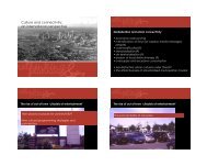
URBAN MORPHOLOGY - urban-design-group.org.uk
URBAN MORPHOLOGY - urban-design-group.org.uk
URBAN MORPHOLOGY - urban-design-group.org.uk

You also want an ePaper? Increase the reach of your titles
YUMPU automatically turns print PDFs into web optimized ePapers that Google loves.
WHO MADE THIS BIG MESS?<br />
Brenda Scheer tries to pin the blame for the morphological<br />
disaster that is the American strip<br />
TOPIC<br />
I’m driving down a calm subdivision road<br />
in any American <strong>urban</strong>ised area (hard<br />
to call them cities, really). Sprawl has its<br />
loveliness: the precise patterns of houses<br />
of similar size, surrounded by a patch of<br />
lawn, facing a street that may soon be lined<br />
with trees. The space between houses is<br />
a regular rhythm, as is the curb cut and<br />
pavement of the driveway and even the<br />
doors of the garages. Although we can<br />
demonise it, it is not hard to see why<br />
Americans adore their own little piece of<br />
castle, tucked into a neat, orderly plot.<br />
But, let’s keep driving, to the dirty little<br />
aesthetic underbelly of the cosy suburb<br />
– the strip. All we need do is leave the<br />
shady acres sign in the rear view mirror,<br />
drive to the main road, and we encounter<br />
a completely different world – chaotic,<br />
charmless and without the redemption<br />
of landscape or private domain. Here, no<br />
visible order prevails. Here is the hated<br />
symbol of sprawl, excess, corporate greed<br />
embodied in a world of shopping centres,<br />
fast food chains, downtrodden oriental<br />
buffets, gas stations, signs, parking lots,<br />
and roads without benefit of a curb, much<br />
less a tree.<br />
A CANCER<br />
Well, having studied it for years, I can<br />
describe it the way a doctor might be able<br />
to describe a cancer – it has a definitive<br />
form that is almost as predictable as<br />
the quiet subdivisions around it. Its<br />
form has subtly changed over the past 50 years since its earliest<br />
versions, but the elements are the same: single storey buildings<br />
in a wide variety of sizes and shapes placed on lots with widely<br />
varied lot widths and depths. All the buildings face one wide<br />
street, although they may address it at an angle. Many lots have<br />
front and back buildings, with the smaller ones in the front<br />
only slightly blocking the view to the rear shops. Parking lots<br />
are everywhere, paving fills in almost every available surface,<br />
except for pathetic landscape islands. Signs dominate the<br />
architecture and the streetscape. The condition of the street is<br />
typically deplorable: weeds, trash, gravel, streetlights, curb cuts<br />
all signalling neglect.<br />
THE CULPRITS<br />
Who made this big mess? Although we universally deplore it<br />
we can’t seem to pin the blame on anyone at all. Sometimes it<br />
feels like we can’t even explain it, like a mysterious cancer that<br />
just appears along a previously uninfected country road. Its not<br />
like we don’t know any better, of course, we have new <strong>urban</strong>ist<br />
models of retail nodes, and even older existing neighbourhood<br />
business districts to help us visualise a different way that<br />
commercial and residential areas could work together.<br />
Why don’t we plan differently, even in circumstances where<br />
we have virgin farmland ready to be developed? Lets see if we<br />
can make the blame for this mess stick to various suspects by<br />
imagining a country road ripe for development, right before<br />
the onslaught of sprawl. First, the planners zoned all the land<br />
along the arterial for commercial use, with minimal setbacks<br />
and a height limit. The land NOT along the street was zoned<br />
exclusively for residential—mostly single family. Planners<br />
assumed that the arterial, the major access route, would have too<br />
much traffic on it to comfortably accommodate residential uses,<br />
so commercial or institutional was their only option. Politically,<br />
they had to zone the entire street that way, even though it would<br />
take a long time for it to develop continuous commercial activity.<br />
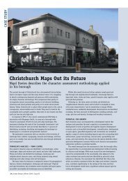
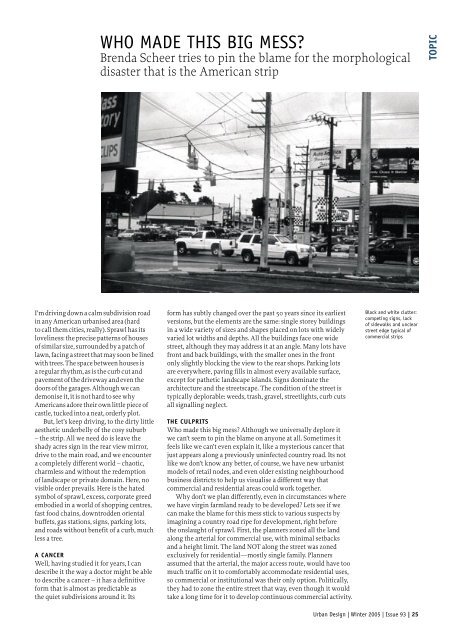
Black and white clutter:<br />
competing signs, lack<br />
of sidewalks and unclear<br />
street edge typical of<br />
commercial strips<br />
Urban Design | Winter 2005 | Issue 93 | 25