PDF - Full-text Article - Geologia Sudetica
PDF - Full-text Article - Geologia Sudetica
PDF - Full-text Article - Geologia Sudetica

Create successful ePaper yourself
Turn your PDF publications into a flip-book with our unique Google optimized e-Paper software.
Ge olo gia <strong>Sudetica</strong>, 2008, 40: 51–63.<br />
Tec tonic evo lu tion of the late Cre ta ceous<br />
Nysa K³odzka Gra ben, Sude tes, SW Po land<br />
Jerzy Don & Ro man Gotowa³a<br />
In sti tute of Geo log i cal Sci ences, Wroc³aw Uni ver sity, Maksa Borna 9, 50-204 Wroc³aw, Po land,<br />
e-mail: ro man.gotowala@ing.uni.wroc.pl<br />
Key words: fault, turbidite, fan delta, Idzików beds, Orlica–Œnie¿nik Dome, Bo he mian Mas sif, Ce no zoic.<br />
Ab stract The Nysa K³odzka Graben, lo cated in the Sudetes of SW Po land, de vel oped as a re sult of Coniacian (mid dle Up per Cre -<br />
ta ceous) N-trending fault ing of the Variscan crys tal line base ment rocks that com prise the crest of the Orlica–Œnie¿nik<br />
Dome. The graben was trans gressed by a late Cre ta ceous sea that en croached dur ing the Cenomanian from the north -<br />
west. Up to 700 m of Coniacian shales, sand stones and con glom er ates were de pos ited in the graben, with shales (the<br />
~500 m thick Idzików ‘clays’) dom i nat ing the graben’s cen tral sec tion. On the west ern side of the graben, shales grade<br />
up wards to greywackes in a style that re sem bles a turbidite se quence; on the east ern side, shales are over lain by sand -<br />
stones and con glom er ates (the Idzików con glom er ates) that rep re sent ex ten sive late Cre ta ceous fan del tas. These<br />
within-graben fan del tas date the on set of fault-block move ments that up lifted the Sudetes re gion dur ing the late Cre ta -<br />
ceous–Ce no zoic. By the end of the Cre ta ceous, both the sed i men tary infill and the un der ly ing Cenomanian and<br />
Turonian strata were steep ened at the graben mar gins and were gently folded, the fold axes par al lel ing the graben’s mar -<br />
ginal faults. Sub se quent Cre ta ceous–Paleocene (‘Laramian’) de for ma tions re sulted in NW-trending re verse fault ing,<br />
which re struc tured the ear lier N–S tem plate of the graben, and in transcurrent faults, which cut the N-trending folds,<br />
mod i fied the north and south ends of the graben and strongly af fected the graben’s west ern walls. The to tal thick ness of<br />
the Up per Cre ta ceous strata of the Nysa K³odzka Graben is 3 times that of the Intra-Sudetic Synclinorium, im ply ing<br />
that the two units de vel oped in de pend ently.<br />
Manu script re ceived 10 Au gust 2008, ac cepted 20 De cem ber 2008<br />
INTRODUCTION<br />
The Nysa K³odzka Gra ben (here af ter the Nysa Gra -<br />
ben) is one of the young est tec tonic units in the Sude tes,<br />
SW Po land. The de vel op ment of the Nysa Gra ben post -<br />
dates the Ce no ma nian ma rine trans gres sion (‘Chalk Sea’),<br />
this trans gres sion be ing fa cili tated by what is now the<br />
K³odzko re gion hav ing a topo graphic re lief at the time of<br />
only a few tens of me tres. Be cause of its young age, the<br />
Nysa Ga ben is eas ily rec og nised in the geo mor phol ogy of<br />
to day (Fig. 1, App. 1).<br />
The Nysa Gra ben is an ~55 km long, N–S trend ing<br />
fea ture that is 12 km wide near K³odzko and Kros nowice<br />
but nar rows to less than 2 km near Štity at its south ern tip<br />
in the Czech Re pub lic (Fig. 1, App. 1). The gra ben started<br />
to de velop dur ing the Co nia cian (Don & Don, 1960), has<br />
its long axis co in ci dent with the trend of the Orlica–<br />
Œnie¿nik Dome crys tal line base ment (Cloos, 1922, 1936)<br />
and is bor dered to the west and east by faults that con trol<br />
the steep mar ginal slopes of the ex posed meta mor phic<br />
base ment bed rock (Figs 2, 3).<br />
The NW part of the gra ben con tains Cre ta ceous in fill<br />
that passes into the Up per Cre ta ceous sedi ments of the<br />
Intra- Sudetic Syn cli nor ium (¯elaŸniewicz & Aleksandrowski,<br />
2008). The bound ary at the Cre ta ceous struc -<br />
tural level be tween these units is rather ar bi trary (Wo je -<br />
woda, 2004). Some re gional over views (e.g., Stupnicka,<br />
1989) have in cluded the Nysa Gra ben in the broader Intra-<br />
Sudetic Syn cli nor ium. In the 1960s and 1970s, the lithos -<br />
tra tigra phy that had ear lier been es tab lished for the Intra-<br />
Sudetic Syn cli nor ium was adapted to the Nysa Gra ben<br />
(Radwañski, 1961, 1975). How ever, de tailed stud ies con -<br />
ducted in the NE part of the gra ben (Don & Don, 1960;<br />
Jerzykiewicz, 1970, 1971) re vealed sig nifi cant dif fer ences<br />
be tween both the sedi men tary fa cies and the struc tural de -<br />
velopment of the Intra-Sudetic Synclinorium and the<br />
Nysa Gra ben since Co nia cian times: for ex am ple, the Co -<br />
nia cian de pos its, es pe cially the Idzików Beds, are nearly 3<br />
times thicker (~1,000 m vs. ~370 m) than their coun ter -<br />
parts in the syn cli nor ium (Don & Wojewoda, 2003;
52 J. DON & R. GOTOWA£A<br />
Fig. 4). Thus, lithostratigraphic correlation between the<br />
gra ben and the syn cli nor ium is still a mat ter of con sid er -<br />
able de bate as a re sult of nu mer ous on- going prob lems: re -<br />
lated map sheets have been given dif fer ent leg ends; there<br />
are ap par ent ‘str atigraphic gaps’ along bounda ries of<br />
neigh bour ing sheets only be cause the rocks were mapped<br />
by dif fer ent peo ple; and that hith erto avail able topo -<br />
graphic maps at the scale of 1:25,000 were pur posely ‘si -<br />
mpl ified’ (dis torted) to meet the im posed re quire ments on<br />
all such data in post- war Po land. All these fac tors have im -<br />
peded making coherent tectonic reconstructions of the<br />
Nysa Gra ben, but the main ob sta cle has been from the in -<br />
ade quate cor re la tion of the wide spread, but poorly ex -<br />
posed, ~500 m thick Idzików ‘clays’: these clays lack any<br />
marker ho ri zons (Don & Don, 1960).<br />
We re- mapped the area of the Nysa Gra ben us ing the<br />
more ac cu rate 1:10,000 topo graphic base maps that were<br />
pub lished in 1976 and that were draughted us ing pho to -<br />
gram met ric data. These maps ac cu rately show the re la -<br />
tion ship be tween bed rock and topo graphic re lief and,<br />
thus, have the po ten tial to more re lia bly iden tify faults<br />
and so aid in tec tonic re con struc tions. Fi nan cial con -<br />
straints meant that no test- pits or trenches could be dug to<br />
confirm certain lithologies or relationships, and this has<br />
undoubtedly influenced the accuracy of our maps.<br />
Field work was con ducted be tween Boboszów, in the<br />
south, and Kros nowice–Polanica Zdrój, in the north<br />
(App. 1). Par ticu lar at ten tion was paid to the gra ben mar -<br />
gins and the tec ton ics of the sedi men tary in fill. No new<br />
stra tigraphic work was car ried out be cause the lithos tra -<br />
tigra phy of the area is al ready well es tab lished (Ge initz,<br />
1843; Bey rich, 1849; Sturm, 1901; Pachucki, 1959; Rad -<br />
wañska, 1960; Teis seyre, 1975; Kêdzier ski, 2002). The at -<br />
tached map in Ap pen dix 1 is the re sult of car to graphic and<br />
struc tural ob ser va tions made in side and along the mar gins<br />
of the Nysa Gra ben.<br />
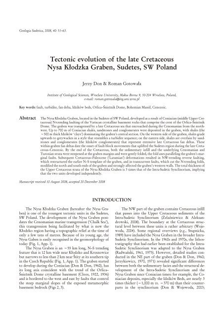
Fig. 1. Tec tonic sktech of the Orlica-Œnie¿nik Dome (af ter<br />
Cymerman (1997), cor rected and sup ple mented). 1 – Up per Cre -<br />
ta ceous; 2 – tonalites and granodiorites, un di vided; 3 – gran ites<br />
and granodiorites; 4 – Up per De vo nian rocks; 5 –K³odzko Meta -<br />
morphic Massif (KU); 6 – Nové Mésto Slate-Greenstone Belt<br />
(NMU); 7 – Zábøeh Schist Belt (ZU); 8 – Stáre Mésto Belt (SMU);<br />
9 – Branna Phyllite Belt (BU); 10 – Keprnik Dome (KD). Ab bre -<br />
vi a tions: BT – Bušin Fault; JG – Jawornik granitoids; KOG –<br />
Kudowa Zdrój-Olešnice granitoids; KT – Krosnowice Thrust;<br />
KZSG – K³odzko-Z³oty Stok granitoids; MSF – Mar ginal Sudetic<br />
Fault; NT – Nýznerov Thrust; OFZ – Orlica Fault Zone; RT –<br />
Ramzova Thrust; VVD – Velké Vrbno Dome; ZSTSZ – Z³oty<br />
Stok-Trzebieszowice Shear Zone; ŽG – Žulova granitoids.<br />
MAR GINS OF THE NYSA GRABEN<br />
Our map of the E and NE flanks of the Nysa Gra ben<br />
modi fies ear lier maps only to a mi nor de gree. One change<br />
is the dis cov ery of a kilometre- long fault that de flects the<br />
course of the east ern mar ginal fault in the Pisary–Heømanice<br />
area. This fault is par al lel to the Štity Fault and the<br />
two bor der the gra ben on its south ern side (Fig. 1, App. 1).<br />
The gra ben started to form dur ing the Co nia cian<br />
when synsedi men tary ac tiv ity on the east ern fault mar gin<br />
gave rise to an asym met ric sub si dence of a sedi men tary ba -<br />
sin that shal lowed west ward. An es ti mated to tal throw on<br />
the east ern mar ginal fault is ~1,600 m in the area of<br />
Czarna Góra, but is even more to the north (Don & Don,<br />
1960). The west ern mar ginal fault de pressed the ba sin<br />
floor by some hun dreds of me ters in the south but by only<br />
sev eral me ters in the north west where the Nysa Gra ben<br />
meets the Intra- Sudetic ba sin (the up per struc tural level of<br />
the Intra- Sudetic Syn cli nor ium). As the gra ben floor stead -<br />
ily sub sided, Ce no ma nian and Tu ro nian beds were ul ti -<br />
mately ro tated into mono clines that de vel oped very steep<br />
to ver ti cal dips along the gra ben’s bor ders. These (sub)ver -<br />
ti cally dip ping beds were then dis placed out wards, while<br />
remaining almost vertical, by local subhorizontal thrusts<br />
(figs 4–8 in Don, 2003). The ver ti cal at ti tude of the east ern<br />
mar ginal fault can be ob served to day in deeply in cised val -<br />
leys in the Œnie¿nik Mas sif area, par ticu larly along the<br />
steep slopes of the Wilc zka Val ley, the Szklarka Val ley<br />
and the Bia³a Woda Val ley (Figs 5 and 6).<br />
A sec ond phase of tec tonic ac tiv ity re sulted in the<br />
flanks of the Nysa Gra ben be ing dis rupted by NW-trending,<br />
nor mal to lo cally re verse faults with a dis crete sin is -<br />
tral strike- slip com po nent. On the Pol ish side of the gra -<br />
ben, the most im por tant NW- trending fault is the ~11<br />
km long Krowi arki Mar ginal Fault (App. 1): be tween<br />
Nowy Wal iszów and Gor zanów, this fault sepa rates meta -<br />
mor phic base ment from gra ben in fill. The Krowi arki<br />
Mar ginal Fault is a part of a re gional fault struc ture that<br />
con tin ues south east ward, via the Œnie¿nik Mas sif and the<br />
Staré Mìsto Belt, to the Ke prník Dome and con tin ues
TEC TONIC EVO LU TION OF THE NYSA K£ODZKA GRABEN 53<br />
Fig. 2. The Nysa Graben and the Góry Bystrzyckie Mts. in the vi cin ity of Miêdzylesie. The Miêdzylesie Up land is on the right.<br />
Fig. 3. The east ern mar gin of the Nysa Graben. The sum mit of Igliczna Mt. is on the left side.
54 J. DON & R. GOTOWA£A<br />
Fig. 4. Lithostratigraphic cor re la tion of Up per Cre ta ceous sed i men tary rocks from Góry Sto³owe (Intra-Sudetic Synclinorium) and<br />
the Nysa Graben (cor rected and sup ple mented by J. Wojewoda af ter Don & Wojewoda (2003)).
TEC TONIC EVO LU TION OF THE NYSA K£ODZKA GRABEN 55<br />
Fig. 5. Pan oramic view of the east ern mar gin of the Up per Nysa Graben in the vi cin ity of Idzików, taken from the Pasterskie Ska³ki<br />
Rocks (Shep herds’ Rocks).<br />
northwest ward as the Ka mienny Grzbiet–Babi lon Fault<br />
Zone (Fig. 1, App. 1). The fault con tains ura nium–fluo -<br />
rine min er ali za tion in the vi cin ity of the vil lage of Kletno<br />
(Ba naœ, 1965) and mag net ite–hema tite min er ali za tion<br />
along the SW slopes of the Krowi arki Mts.<br />
At the south ern tip of the Nysa Gra ben there is the re -<br />
verse, S- dipping, Štity Fault (Don et al., 2003). This fault<br />
runs par al lel to the Krowi arki Mar ginal Fault and can be<br />
taken as its re gional coun ter part. Be tween these two faults,<br />
the east ern flank of the gra ben is cut by sev eral smaller<br />
faults (Don et al., 2003) of which the Ur wista Moun tain<br />
Fault in the Pisary- Heømanice area, with its strike- slip<br />
kine mat ics, ap pears to be the more sig nifi cant be cause it is<br />
par al leled by three other smaller, un named faults that,<br />
when taken to gether, off set the south ern part of the gra -<br />
ben sin is trally by ~3 km (Fig. 7, App. 1). These smaller<br />
faults do not ap pear on ear lier geo logi cal maps, de spite the<br />
pres ence of U- mineralization in the vi cin ity of Ko pal ni ana<br />
Góra, near Po toc zek (Fig. 1, App. 1). The mid dle fault of<br />
the three has un der gone neo tec tonic re ac ti va tion: this can<br />
be seen from the dis rup tion of sev eral me tres in thick ness<br />
of so li fluc tion gneiss de bris. Dur ing the Ice Age, this<br />
gneiss de bris moved some hun dreds me tres down the<br />
slope of Ur wista Moun tain, abrad ing the sur face of the<br />
Up per Cre ta ceous de pos its that filled the Nysa Gra ben.<br />
The north ern, hang ing wall of this mid dle fault was ele -<br />
vated then by 4 me tres. It is the only map pa ble evi dence of<br />
neo tec tonic fault dis place ments at the east ern mar gin of<br />
the gra ben. Ac tiv ity on the Ur wista Fault also af fected the<br />
Tu ro nian marls on the south ern slopes of Ko pal ni ana<br />
Góra near Po toc zek, caus ing them to reach the level of the<br />
extensive, southerly inclined, Jod³ów peneplain. The latter<br />
was in ter preted by Schwarzbach (1934) as a pos si ble ‘te -<br />
rrace’ of the late Cre ta ceous sea. There are also some<br />
smaller re verse faults (Fr¹ckiewicz, 1965; Fr¹ckiewicz &<br />
Teis seyre, 1977) that cut the gra ben’s east ern mar gin near<br />
the vil lages of Goworów and Nowa Wieœ. These lat ter<br />
faults con tinue into the cen tre of the Nysa Gra ben.<br />
The west ern mar gin of the Nysa Gra ben is topographically<br />
in re lief only along its me ridi on ally trend ing<br />
south ern sec tor where gra ben in fill is in fault con tact with<br />
the meta mor phic rocks of the Or lické hory Moun tains<br />
(App. 1). The south ern part of the west ern mar gin is sin is -<br />
trally off set by 3 km along the NW–SE Králiky–Kamieñczyk<br />
Fault and, fur ther north, is dis placed with simi lar<br />
kinematics by an other 2 km along the Heømanice–<br />
Urwista–Roztoki–Porêba Fault Zone. Still fur ther north,<br />
most of the NW- trending faults that cut across the Góry<br />
Bystrzyckie Moun tains mar gin of the Nysa Gra ben are<br />
also the re sult of Cenozoic- age tec tonic re- structuring of<br />
the en tire area, i.e., the north ern parts of the Intra- Sudetic<br />
Syn cli nor ium and the Nysa Gra ben. The NW- trending<br />
faults all pene trate into the gra ben’s in te rior and they of -<br />
ten merge with the faults that in ter sect the gra ben’s east -<br />
ern margin (Domaszków–Goworów, D³ugopole–Nowa<br />
Wieœ and Zab³ocie–Idzików Faults; App. 1). Be tween<br />
these sets of faults syn clines and an ti clines emerged. The<br />
syn clines, which have the Co nia cian Idzików Beds in their<br />
cores, are sepa rated by SE- plunging an ti clines, which have<br />
meta mor phic bed rock in their re spec tive cores. From the<br />
south to the north, the se quence of syn clines and an ti -<br />
clines are as fol lows: the Miêdzy le sie–Roz toki Syn cline;<br />
the D³ugopole Zdrój An ti cline; the Wil kanów Syn cline;<br />
the Bystrzyca K³odzka An ti cline; and the Idzików–Kros -<br />
nowice Syn cline (App. 1). The D³ugopole Zdrój and Bystrzyca<br />
K³odzka An ti clines are sepa rated from the gra ben<br />
in te rior by the S- trending Nysa Fault, which abruptly<br />
trun cates the Krowi arki Meta mor phic Belt to the north.<br />
De tails of these an ti cline struc tures will be de scribed in a<br />
pa per dedi cated to the tec ton ics of the Góry Bystrzyckie<br />
Moun tains area (J. Don, in prepa ra tion).<br />
The bor der be tween the Nysa Graben and the Intra-<br />
Sudetic Synclinorium is herein de fined as co in ci dent with<br />
the ex tent of the Coniacian Idzików Beds in the Krosnowice<br />
Syncline. The Idzików Beds are closely con nected<br />
with the evo lu tion of the Nysa Graben.<br />
TEC TON ICS OF THE IN TE RIOR OF THE NYSA GRABEN<br />
The ~500 m thick Idzików “clays” out crop widely in<br />
the Nysa Graben but, be cause they lack any marker ho ri -<br />
zon, are dif fi cult to use for tec tonic re con struc tions. Un -<br />
der such cir cum stances, sand stones that over lie the “clays”
56 J. DON & R. GOTOWA£A<br />
Fig. 6. The east ern mar gin of the Nysa Graben be tween Idzików and Marianówka.<br />
Fig. 7. The Nysa Graben south of the Urwista Mt.
TEC TONIC EVO LU TION OF THE NYSA K£ODZKA GRABEN 57<br />
and struc tures from the mar gins of the Nysa Graben be -<br />
come im por tant be cause they can be used to solve the tec -<br />
tonic prob lems of the graben in te rior.<br />
The Pol ish part of the Nysa Graben falls into three de -<br />
fined sec tors: the Miêdzylesie–Roztoki sec tor to the south;<br />
the Krosnowice–Idzików sec tor to the north; and the cen -<br />
tral Domaszków sec tor. The Miêdzylesie–Roztoki and<br />
Krosnowice–Idzików sec tors form sec ond ary syn clines.<br />
They are sep a rated by the Domaszków sec tor, which de -<br />
vel oped as an ex ten sion of the D³ugopole Zdrój and<br />
Bystrzyca K³odzka Anticlines. In the syncline sec tors, the<br />
com plete lithostratigraphic pro files of the Up per Cre ta -<br />
ceous can be ob served, whereas the el e vated parts have the<br />
youn gest mem bers of the Idzików Beds, which are com -<br />
posed of sand stones and con glom er ates, eroded away.<br />
These lat ter rock types in the syn clines sec tors are geomorphologically<br />
recognisable as steep slopes and kuestas<br />
be cause of their higher re sis tance to weath er ing. Thus, the<br />
syn clines, al though they are tec toni cally downwarped fea -<br />
tures, co in cide with the pos i tive geomorphological fea -<br />
tures of the Miêdzylesie Up land (Fig. 8) and the Idzików<br />
Upland (Fig. 9), respectively.<br />
The base of the coarse clastic mem bers act as marker<br />
ho ri zons and prove very use ful in tec tonic re con struc -<br />
tions. On the NW side of the Nysa Graben, the sed i ment<br />
se quences be tween the un der ly ing clays and the over ly ing<br />
sand stones of the Idzików Beds are graded.<br />
MIÊDZYLESIE–ROZTOKI SYNCLINE<br />
The Miêdzylesie–Roztoki Syncline is bor dered by the<br />
Králiky–Kamieñczyk Fault to the south and the Domaszków–Goworów<br />
Fault to the north. The Miêdzylesie–<br />
Roztoki Syncline is also di vided in ter nally by the Porêba–<br />
Roztoki Fault into a north ern (Roztoki) and a south ern<br />
(Miêdzylesie) sec tion. The bor der faults cut the Nysa<br />
Graben obliquely and pro duce sinistral strike-slip off sets<br />
of the graben’s N-trending bound aries. The south ern fault<br />
ter mi nates to the north-west against a re verse fault that<br />
sep a rates the sed i men tary infill of the graben from the<br />
meta mor phic bed rock ex posed in the Góry Bystrzyckie<br />
Moun tains up as far as Porêba (Don, 2003). We mapped<br />
the base of the Idzików sand stones in the Nysa K³odzka<br />
val ley and ad ja cent trib u tar ies and rec og nized the pres ence<br />
of open up right folds with gently dip ping limbs. These<br />
folds be come steeper only near the graben mar gins and<br />
close to the transcurrent faults (App. 1). In side the graben,<br />
a me rid i o nal fault was mapped be tween Boboszów and<br />
Szklarnia (App. 1) and proves to be a con tin u a tion of the<br />
Nysa Fault to the north. The west ern limb of the me rid i o -<br />
nal fault was down thrown in Palaeogene time by ~15–20<br />
m and this forced the Nysa K³odzka river in the Pisary vi -<br />
cin ity to change its course from a west erly to a south erly<br />
di rec tion. Be fore its cap ture, the Nysa river joined the<br />
Dzika Orlica river and was then part of the North Sea<br />
river ba sin (Sroka & Kowalska, 1998).<br />
A gen tle fold ing of Cre ta ceous beds in the Miedzylesie<br />
part of the Miêdzylesie–Roztoki Syncline was fol lowed by<br />
block tec ton ics. Some of our newly mapped faults<br />
obliquely cut this syncline. The fold axis in the Miêdzylesie<br />
part of the mar ginal Miêdzylesie–Roztoki Syncline is<br />
par al lel to the west ern mar gin of the Nysa Graben be -<br />
tween Miêdzylesie and Smreczyny where it is cut by the<br />
Porêba–Roztoki Fault, to the north (App. 1). Gen tle dips<br />
of the limbs of this syncline can be de duced from the out -<br />
crop pat tern of the basal sand stones ob served in trib u tary<br />
val leys. In the field, ap par ent dips in ex cess of 10° can be<br />
ob served, but larger dip an gles of ten rep re sent cross bed -<br />
ding and can not be used, un cor rected, for tectonic reconstructions.<br />
Two re search bore holes in the Miêdzylesie vi cin ity<br />
reached crys tal line bed rock: in Pisary at a depth of 739 m,<br />
and in Smreczyna at 737 m (Radwañski, 1975). They<br />
prove that the Up per Cre ta ceous de pos its there are much<br />
thicker than the pre vi ous es ti mate of only ~ 400 m).<br />
CEN TRAL ANTICLINE OF THE NYSA<br />
GRABEN<br />
Morphologically, the N-trending Central Anticline of<br />
the Nysa Graben co in cides with a low land that sep a rates<br />
the Miêdzylesie and Idzików Up lands, both of which tec -<br />
tonically represent synclines. Geologically, the Central<br />
Anticline is sub or di nate to the east ern mar gin of the<br />
graben and struc tur ally bor dered by the N-trending Nysa<br />
Fault and the Szklarnia– Boboszów Fault (App. 1). These<br />
faults trun cate the D³ugopole Zdrój and Bystrzyca Anticlines<br />
with the in ter ven ing shal low Wilkanów Syncline,<br />
the three units which plunge to the SE to ward the graben<br />
mar gin. In the Cen tral Anticline area, only thick lower<br />
clayey mem bers of the Idzików Beds oc cur, with no<br />
marker ho ri zon, be cause the youn gest sand stone and con -<br />
glom er ate mem bers have been eroded away. The bed ding<br />
planes of shales dip at 5–15° in cha ot i cally dif fer ent di rec -<br />
tions and do not match with any co her ent struc tural unit.<br />
The pres ence of up per Turonian marls mapped in the bor -<br />
der area be tween the Wilkanów Syncline and the Cen tral<br />
Anticlne is dif fi cult to ex plain. These marls out crop over<br />
an area of about 1 km 2 , and ap par ently form a ‘block’ that<br />
emerges from be neath the Idzików ‘clays’ on its south ern<br />
side and that is bor dered by faults on the other three sides.<br />
The east ern fault of this block is the Nysa fault which<br />
trun cates the Bystrzyca Anticline and con tin ues fur ther<br />
north where it con sti tutes the west ern bor der of the Krowiarki<br />
Meta mor phic Belt be tween Gorzanów and Krosnowice<br />
(App. 1). The north ern fault of the marl block can<br />
be traced from the east ern mar gin of the Nysa Graben in<br />
the vi cin ity of Marianówka, via the D³ugopole Dolne area<br />
the west ern mar gin of the graben. The el e vated marl block<br />
may ap pear in the ax ial por tion of the Wilkanów Syncline<br />
be cause it con sti tutes a part of the SE ex ten sion of the<br />
Bystrzyca Anticline (App. 1).<br />
IDZIKÓW–KROSNOWICE SYNCLINE<br />
The Idzików–Krosnowice Syncline is sub di vided into<br />
two parts by the NW-trending Kamienny Grzbiet–Babi-
58 J. DON & R. GOTOWA£A<br />
Fig. 8. The Nysa Graben and the Miêdzylesie Up land can be seen in the left part of the pho to graph. In the back ground are the Góry<br />
Bystrzyckie Mts., which lie to the west of Miêdzylesie.<br />
lon Fault Zone. The north west ern part is re ferred to as the<br />
Krosnowice Syncline and the south east ern part as the Idzików<br />
Syncline (App. 1).<br />
The Idzików Syncline has the shape of a rhomb elon -<br />
gated in the SE–NW di rec tion: it is bor dered by the mar -<br />
ginal faults of the Nysa Graben to the east and north east,<br />
but its west ern bound ary is de fined by the in ner Idzików–<br />
Zab³ocie and Nysa Faults that run par al lel to the graben.<br />
Mor pho log i cally, the east ern part of the syncline co in -<br />
cides with the Idzików Up land (Fig. 9) and com prises<br />
sand stones and con glom er ates sur rounded on all sides by<br />
out crops of the un der ly ing Idzików ‘clays’ (shales), which<br />
ap pear in top o graphic de pres sions. The east ern limb of the<br />
Idzików Syncline is monoclinally tilted and at tains a ver ti -<br />
cal at ti tude in an ap prox i mately 1 km wide zone at the<br />
con tact with the east ern mar gin of the Nysa Graben (Fig.<br />
10 a, b). The west ern limb of the syncline dips east ward at<br />
an an gle of ~10° whereas the SW limb has been ro tated<br />
Fig. 9. Pan orama of the Idzików Up land as viewed from the south (from Marianówka).
TEC TONIC EVO LU TION OF THE NYSA K£ODZKA GRABEN 59<br />
and at tains dips of ~30° at the transcurrent Idzików–<br />
Zab³ocie Fault that it self cuts the syncline obliquely and<br />
con tin ues to wards Bystrzyca Anticline. Lithologically, the<br />
syncline com prises sand stones that al ter nate with con -<br />
glom er ates in lay ers that grad u ally taper out west ward<br />
over the dis tance of ~2 km to be lithologically re placed<br />
by finer-grained sand and clayey al ter na tions. Seven con -<br />
glom er ate lay ers, with in di vid ual clasts up to 15 cm in di -<br />
am e ter, were mapped. These con glom er ates ap pear to be<br />
the eroded re mains of the crys tal line base ment rocks of<br />
the Nysa Graben walls, al though clasts of por phyry and<br />
sand stone peb bles are also pres ent. In the Idzików–Nowy<br />
Waliszów area, con glom er ates formed part of delta fans<br />
that were sourced mainly from the east ern limb of the<br />
Orlica–Œnie¿nik Dome: the meta mor phic base ment rocks<br />
of this dome were be ing up lifted at the end of the Coniacian.<br />
Ver ti cal move ments dur ing the Coniacian marked<br />
the on set of a pe riod of ‘block tectonics’ in the Sudetes<br />
after a relatively long period of diastrophic quiescence<br />
during the Mesozoic.<br />
In the Idzików Syncline, sand stones and con glom er -<br />
ates are un der lain by the Idzików ‘clays’, which are wide -<br />
spread in the top o graphic de pres sions that sur round the<br />
Idzików Up land (Fig. 9). The Idzików ‘clays’ are al most<br />
ver ti cal when ad ja cent to the graben’s east ern mar ginal<br />
fault and their out crops nar row to ~500 m, which is the<br />
true or thogo nal strati graphic thick ness of these rocks. To<br />
the west, in the vi cin ity of Stary Waliszów, where the<br />
‘clays’ dip at an an gle of 5–10°, their out crops are up to 3<br />
km wide. A set of par al lel faults sep a rate the ‘clays’ from<br />
up per Turonian marls of the Bystrzyca Anticline. The<br />
east ern most fault of this set likely con tin ues into the Nysa<br />
Fault bor der ing in the west the Krowiarki Moun tains.<br />
Nearby, at Gorzanów, all these faults in ter sect the sinistral,<br />
W-trending, strike-slip Kamienny Grzbiet–Babilon<br />
Fault Zone. At the junc tion of these faults there oc cur<br />
min eral wa ter springs. Mu tual re la tion ships of the two re -<br />
gion ally im por tant fault zones are dif fi cult to de ci pher<br />
without additional hydrogeologic and geophysical studies<br />
which would com plete the field ob ser va tions per formed at<br />
the sur face. The Kamienny Grzbiet–Babilon Fault Zone<br />
can be traced west ward from the vil lage of Piotrowice<br />
(Krowiarki Moun tains) to the vil lage of Pokrzywno<br />
(south of Polanica Zdrój; App. 1). In the vi cin ity of Piotrowice,<br />
it off sets the Krowiarki Mar ginal Fault, which<br />
was formed during the second phase of the evolution of<br />
the graben (Don, 1996).<br />
The Krosnowice Syncline oc curs north of the Kamienny<br />
Grzbiet–Babilon Fault Zone (Fig. 11). The north -<br />
west ern limb of this syncline lies along the Wielis³awka<br />
Val ley where the Idzików ‘clays’ di rectly onlap the marls<br />
of the Up per Turonian. It is this ar bi trary onlap bound ary<br />
that has been as sumed to dis tin guish the Cre ta ceous infill<br />
of the Nysa Graben from con tem po ra ne ous strata of the<br />
Intra-Sudetic Synclinorium. The other bound aries of the<br />
Krosnowice Syncline are tectonic.<br />
The Kamienny Grzbiet–Babilon Fault Zone con tin -<br />
ues to the ESE across Babilon Hill in the vi cin ity of the vil -<br />
lage of Piotrowice, where it dis rupts the Krowiarki Mar -<br />
ginal Fault. In the Nysa K³odzka val ley near Krosnowice,<br />
the east ern bound ary of the Krosnowice Syncline co in -<br />
cides with the Nysa Fault, which trun cates the Krowiarki<br />
Meta mor phic Belt. The north east ern bor der of the Krosnowice<br />
Syncline be tween Krosnowice and Wielis³aw<br />
Dolny is de fined by the mar ginal K³odzko Meta mor phic<br />
Fault Zone. In this zone, the Cre ta ceous beds (Fig. 12) and<br />
the Rotliegend red con glom er ates (Fig. 13) are rotated into<br />
the vertical.<br />
The rocks of the Krosnowice Syncline are al most ex -<br />
clu sively rep re sented by the Idzików ‘clays’ (Fig. 14).<br />
Along the syncline axis, how ever, there are also some lo cal<br />
subsidiary alternations of turbidites (Jerzykiewicz, 1970,<br />
1971). In the vi cin ity of Stary Wielis³aw, SE of Polanica<br />
Zdrój, and in Krosnowice Dolne, in the ax ial part of the<br />
Krosnowice Syncline, there are eas ily mapped small sand -<br />
stone out crops un der lain by the Idzików‘clays’ (App. 1).<br />
Only along the west ern scarp side of the Nysa river the<br />
beds dip east ward at an an gle of up to 25°. The east erly<br />
plung ing Krosnowice Syncline be comes wider in this di -<br />
rec tion and reaches a width of 6 km in the Nysa K³odzka<br />
Val ley where the Nysa Fault bor ders the meta mor phic<br />
base ment of the Krowiarki Mountains.<br />
At the top of the Idzików ‘clays’ there are ubiq ui tous<br />
iron con cre tions (Fig. 15), which oc cur ex ten sively<br />
through out the Nysa Graben area. They formed un der re -<br />
ducing conditions when the Cretaceous sedimentary basin<br />
nar rowed and closed. At the end of the Coniacian, and<br />
pos si bly also dur ing the Emsherian (late Cre ta ceous), a re -<br />
gres sion of the ‘Chalk Sea’ had started and the ba sin of the<br />
cen tral Nysa Graben was steadily filled up with ex ten sive<br />
fan del tas com posed of the Idzików sandstones and conglomerates.<br />
The Nysa Graben’s tec tonic evo lu tion oc curred in<br />
suc ces sive stages through out the whole Ce no zoic. This<br />
can be in ferred from the suc ces sion of ob serv able pe ne -<br />
plains (Fig. 16) in the nearby Œnie¿nik Meta mor phic Mas -<br />
sif (Don, 1989), which be gan up lift ing dur ing the late Cre -<br />
ta ceous. The pe ne plains were formed at pe ri ods of rel a tive<br />
tec tonic qui es cence, those that de vel oped dur ing the Mio -<br />
cene and Plio cene be ing among the most ex ten sive, with<br />
rel ics of a weath ered terra rossa crust occuring on the Mio -<br />
cene pe ne plain. The Mio-Plio cene pe ne plain, how ever,<br />
was ac com pa nied by some vol ca nic ac tiv ity, which pro -<br />
duced a ba saltic cone ~5.46 Ma old over ly ing the grav els<br />
of the Bia³a L¹decka river ter race to the NW of L¹dek<br />
Zdrój (Birkenmajer et al., 2002).<br />
CONCLUSIONS<br />
Af ter a long pe riod of Me so zoic qui es cence, late Cre -<br />
ta ceous block tec ton ics started to up lift the Sudete re gion<br />
and to ini ti ate the Nysa Graben. Con trary to ear lier views<br />
(Cloos, 1936), this up lift was not a sin gle-stage event but<br />
rather a multiphase pro cess that com menced dur ing the<br />
Coniacian. The most im por tant move ments were prob a -<br />
bly compressional ones at the Cre ta ceous/Paleogene boundary<br />
(‘Laramian’), which fol lowed ear lier extensional<br />
ones. Un der com pres sion, new sec tions of the graben fault<br />
bound aries be came ac tive and they obliquely cross-cut the
60 J. DON & R. GOTOWA£A<br />
Fig. 10. The Pasterskie Ska³ki Rocks ex pose. (A) the polymictic Idzików con glom er ates, and (B) form a steeply dip ping monoclinal<br />
ridge that stretches north from Idzików to Nowy Waliszów in the east ern mar gin of the Nysa Graben (cf. Fig. 9).<br />
Fig. 11. Tec tonic brec cia of the Kamienny Grzbiet–Babilon Fault Zone at Pokrzywna south of Polanica Zdrój (ex posed here in house<br />
foundations).
TEC TONIC EVO LU TION OF THE NYSA K£ODZKA GRABEN 61<br />
Fig. 14. Idzików ‘clays’ with thin interlayers of greywacke sand -<br />
stones ex posed along the Mielnik–Gorzanów road.<br />
Fig. 12. Steeply dip ping Cre ta ceous beds on the east ern slope of<br />
the Czerwona Góra Mt. at Krosnowice.<br />
Fig. 15. Iron con cre tions at the top of the Idzików ‘clays’.<br />
Fig. 13. A steep monocline of Rotliegend con glom er ates on the<br />
left side of the Bystrzyca Dusznicka river be tween Szalejów and<br />
Wielis³aw Dolny.<br />
older struc tures of the graben. Dur ing the compressional<br />
phase, the re verse, NW-trending faults were formed at the<br />
north ern and south ern bound aries of the Nysa Graben<br />
and were ac com pa nied by mi nor graben-par al lel and di ag -<br />
o nal faults. Al though dy ing out east ward, the re verse di ag -<br />
o nal faults sig nif i cantly changed the struc tural tem plate of<br />
the west ern graben mar gin where a num ber of fold–fault<br />
blocks (Miêdzylesie–Roztoki Syncline, D³ugopole Zdrój<br />
Anticline, Wilkanów Syncline, Bystrzyca Anticline, Idzików–Krosnowice<br />
Syncline) had de vel oped oblique to the<br />
main N–S course of the graben. In side the Nysa Graben,<br />
we mapped sev eral hith erto un re cog nised Ce no zoic faults,<br />
in clud ing the Kamienny Grzbiet–Babilon Fault Zone and<br />
a fault trending nor mal to this, the Nysa Fault. The Ce no -<br />
zoic faults are not well dated and re quire fur ther study, as<br />
do a num ber of lo cal faults that par al lel the main tec tonic<br />
trend of the Nysa Graben.<br />
Ac cord ing to physiogeographical cri te ria, the Nysa Graben<br />
is a di vide be tween the West Sudetes and the East Sudetes. Such a
62 J. DON & R. GOTOWA£A<br />
Fig. 16. Pe ne plains of the Œnie¿nik Meta mor phic Unit. (A)Sed i men tary se ries of the Up per Nysa Graben com posed of the fol low ing<br />
rocks: 1 – Cenomanian and Turonian marls and sand stones; 2 – shales lo cally interlayered with greywackes, which form part of the base<br />
of the Idzików beds; 3 – polymictic con glom er ates lo cally interlayered with greywackes, which form the top parts of the Idzików beds.<br />
(B) Rocks of the Œnie¿nik Meta mor phic Unit. 1 – the Stronie For ma tion mica schist (1a) interlayered with mar bles (1b) and with erlans<br />
(hornfels) (1c); 2 – Œnie¿nik gneiss es, which can be seen as a fine-grained aplit ic vari ant (2a) and as a coarse augen vari ant (2b). (C) Ba saltic<br />
veins and volcanogenic de pos its. The pe ne plains are chro no log i cally la belled as fol lows: Pc –Palaeo cene, E – Eocene, Ol 1+2 – Oligocene,<br />
Ol 3 –M 1 – Late Oligocene–Mio cene, M 2 – Mid dle Mio cene, M 3 –P l – Late Mio cene–Plio cene. Other ab bre vi a tions are: JN –<br />
NiedŸwiedzia Cave, JR – Radochowska Cave, f – phases of orogenic move ments. Num bers in di cate pe ne plains’ heights above sea level.<br />
di vi sion is not matched by the ge ol ogy of the base ment units,<br />
how ever. This is be cause a tec tonic bound ary be tween the West<br />
and East Sudetes co in cides with the Nyznerov–Ramzova Thrust<br />
Zone (Don et al., 2003), which is a part of the Moldanubian<br />
Thrust that it self is taken as the bor der be tween var i ous Gond -<br />
wana-de rived ter ranes of the Bo he mian Mas sif and Brunovistulia<br />
(Franke & ¯elaŸniewicz, 2000, 2002; Oberc-Dziedzic & Madej,<br />
2002).<br />
Ac knowl edge ments<br />
We greatfully ac knowl edge Dr. T. Jerzykiewicz for con -<br />
struc tive dis cus sion on this pa per and Dr. P. Roycroft and Dr. A.<br />
¯elaŸniewicz for their help in pre par ing the manu script. Dr J.<br />
Wojewoda is thanked for Fig. 4.<br />
REFERENCES<br />
BANAŒ, M., 1965. Przejawy mineralizacji w metamorfiku<br />
Œnie¿nika K³odzkiego [Signs of min er al iza tion in the meta -<br />
mor phic com plex of Œnie¿nik K³odzki (Sudetes Mts.)]. Prace<br />
Geologiczne Komitetu Nauk Geologicznych PAN, 27: 70–82.<br />
BEYRICH, E., 1849. Untersuchungen des Quadersandsteingebirge<br />
in Schlesien. Zeitschrift der Deutschen Geologischen<br />
Gesellschaft, Bd 1: 390–392.<br />
BIRKENMAJER, K., PEÈSKAY, Z., GRABOWSKI, J.,<br />
LORENC, M.W., & ZAGO¯D¯ON. P., 2002. Ra dio met -<br />
ric dat ing of the Ter tiary volcanics, Lower Silesia, Po land.<br />
II. K-Ar and palaeomagnetic data from Neo gene basanites<br />
near L¹dek Zdrój, Sudetes Mts. Annales Societatis Geologorum<br />
Poloniae, 72: 119–129.<br />
CLOOS, H., 1922. Der Gebirgsbau Schlesiens und die Stellung<br />
seiner Bodenschätze. Gebrüder Borntraeger, Berlin, 8°, ss.<br />
VIII, 107 p.<br />
CLOOS, H., 1936. Einführung in die Geologie. Ein Lehrbuch der<br />
inneren Dy namic. Gebrüder Borntraeger, Berlin, 503 p.<br />
CYMERMAN, Z., 1997. Struc ture, ki ne mat ics and an evo lu tion<br />
of the Orlica–Œnie¿nik Dome, Sudetes. Prace Pañstwowego<br />
Instytutu Geologicznego, CLVI: 1–120.<br />
DON, J., 1989. Jaskinia na tle ewolucji geologicznej Masywu<br />
Œnieznika [Geo logic Evo lu tion of the Œnie¿nik Mas sif and<br />
the Cave]. In: Jahn, A., Koz³owski, S. & Wiszniowska, T.
TEC TONIC EVO LU TION OF THE NYSA K£ODZKA GRABEN 63<br />
(Eds.), Jaskinia NiedŸwiedzia w Kletnie. Ossolineum, Wroc³aw,<br />
58–79.<br />
DON, J., 1996. The Late Cre ta ceous Nysa Graben: im pli ca tions<br />
for Me so zoic–Ce no zoic fault-block tec ton ics of the Sudetes.<br />
Zeitschrift für Geologische Wissenschaften, 24: 317–324.<br />
DON, J., 2003. The prob lem of “di a strophic” blocks in the mar -<br />
ginal parts of the Late Cre ta ceous Nysa K³odzka graben, the<br />
Sudetes, SW Po land. <strong>Geologia</strong> <strong>Sudetica</strong>, 35: 61–67.<br />
DON, B. & DON, J., 1960. Geneza rowu Nysy na tle badañ<br />
wykonanych w okolicy Idzikowa [Notes on the or i gin of<br />
the Nysa Graben]. Acta Geologica Polonica, 10: 71–106.<br />
DON, J., SKÁCEL, J. & GOTOWA£A, R., 2003. The bound -<br />
ary zone of the East and West Sudetes on the geo log i cal map<br />
of the Velké Vrbno, Staré Mésto and Œnie¿nik Meta mor phic<br />
Units. <strong>Geologia</strong> <strong>Sudetica</strong>, 35: 25–59.<br />
DON, J. & WOJEWODA, J., 2003. Tektonika rowu górnej<br />
Nysy K³odzkiej – sporne problemy – dyskusja [Tec ton ics of<br />
up per Nysa K³odzka Graben – con tro ver sial is sues – dis cus -<br />
sion]. Przegl¹d Geologiczny, 53: 212–221.<br />
FR¥CKIEWICZ, W., 1965. Ob ser va tions of the di rect con tact<br />
of the Œnie¿nik gneiss es and the Up per Cre ta ceous sed i -<br />
ments at Nowa Wieœ and Wilkanów, near Bystrzyca<br />
K³odzka. Biuletyn Instytutu Geologicznego, 181: 5–22.<br />
FR¥CKIEWICZ, W. & TEISSEYRE, H., 1977. Objaœnienia do<br />
szczegó³owej mapy geologicznej Sudetów. Arkusz Miêdzygórze<br />
1: 25 000. Instytut Geologiczny; Warszawa.{in Pol ish<br />
only}<br />
FRANKE , W. & ¯ELANIEWICZ, A., 2000. The east ern ter -<br />
mi na tion of the Variscides: terrane cor re la tion and ki ne -<br />
matic evo lu tion. In: Franke, W., Haab, V., Oncken, O., &<br />
Tan ner, D. (Eds.) Orogenic Processes: Quantification and<br />
Mod el ling in the Variscan Belt. Geological Society, London,<br />
Spe cial Pub li ca tions, 179: 63–86.<br />
FRANKE, W. & ¯ELANIEWICZ, A., 2002. Struc ture and<br />
Evolution of the Bohemian Arc. In: Winchester, J.,<br />
Pharoah, T. C., & Ver ni ers, J. (Eds.) Palaeozoic Amal gam -<br />
ation of Cen tral Eu rope. Geo log i cal So ci ety, Lon don, Spe cial<br />
Pub li ca tions, 201: 279–293.<br />
GEINITZ, H. B., 1843. Die Versteinerungen von Kieslingswalde<br />
und Nachtrag zur Charakteristik des sächsisch-böhmischen<br />
Kreidegebirges. Arnol- dische Buchhandlung, Dresden: Teil<br />
IV: 23 p.<br />
JERZYKIEWICZ, T., 1970. The Up per Cre ta ceous turbidite se -<br />
quence in the Sudetes (South-West ern Po land). Bulletin of<br />
the Pol ish Acad emy of Sci ences, Earth Sci ences, Série Géologie et<br />
Géographie, 18/3: 149–159.<br />
JERZYKIEWICZ, T., 1971. A flysch/lit to ral suc ces sion in the<br />
Sudetic Up per Cre ta ceous. Acta Geologica Polonica, 21: 165–<br />
199.<br />
KÊDZIERSKI, M., 2002. Stratygrafia i paleobiogeografia osadów<br />
kredy opolskiej i dolnych warstw idzikowskich na podstawie<br />
nanoplanktonu wapiennego. PhD the sis, un pub lished, Li -<br />
brary ING UJ, Kraków {in Pol ish only}<br />
OBERC-DZIEDZIC, T. & MADEJ, S., 2002: The Variscan<br />
overthrust of the Lower Palaeozoic gneiss unit on the Cadomian<br />
base ment in the Strzelin and Lipowe Hills mas sifs,<br />
Fore-Sudetic Block, SW Po land: is this part of the East-West<br />
Sudetes bound ary? <strong>Geologia</strong> <strong>Sudetica</strong>, 34: 39–58.<br />
PACHUCKI, Cz., 1959. O stratygrafii i litologii kredy w rowie<br />
Nysy K³odzkiej [Über die Stratigraphie und Litologie der<br />
Kreide im Neissegraben]. Annales Universitatis Mariae<br />
Curie-Sk³odowska, Sectio B, 12: 1–66.<br />
RADWAÑSKA, Z., 1960. O wieku tzw. “i³ów idzikowskich”<br />
[On the Age of the so-called “Idzików Clays”]. Z badañ<br />
geologicznych na Dolnym Œl¹sku VIII, Biuletyn Instytutu<br />
Geologicznego, 151: 5–24.<br />
RADWAÑSKI, S., 1961. Deltowe osady koniaku w okolicy<br />
Idzikowa [Delta de pos its of the Coniacian in the re gion of<br />
Idzików (Lower Silesia)]. Kwartalnik Geologiczny, 5: 108-<br />
121.<br />
RADWAÑSKI, S., 1975. Kreda Sudetów Œrodkowych w œwietle<br />
wyników nowych otworów wiertniczych [Up per Cre ta -<br />
ceous of the cen tral part of the Sudetes in the light of new<br />
bore hole ma te ri als]. Biuletyn Instytutu Geologicznego, 187:<br />
5–59.<br />
SCHWARZBACH, M., 1934. Die Entstehung der Tannendorfer<br />
“Terrasse” im Glazer Schneegebirge (Spieglitzer Schneeberg).<br />
Firgenwald 7/3: 107–113.<br />
SROKA, W. & KOWALSKA, A., 1998. The preglacial flu vial<br />
de pos its in the south ern part of the Up per Nysa De pres -<br />
sion, cen tral Sudetes Mts., south west ern Po land. <strong>Geologia</strong><br />
<strong>Sudetica</strong>, 31: 157–170.<br />
STUPNICKA, E., 1989. <strong>Geologia</strong> regionalna Polski. Wydawnictwa<br />
Geologiczne. Warszawa. 286 p.{in Pol ish only}<br />
STURM, F., 1901. Der Sandstein von Kieslingswalde in der<br />
Grafschaft Glatz und seine Fauna. Jahrbuch der Königlichen<br />
Preuâischen Geologischen Landes-Anstalt, 21: 30–98.<br />
TEISSEYRE, B., 1975. Stratygrafia mikrofaunistyczna górnej<br />
kredy rowu Nysy (Sudety Œrodkowe) [Stra tig ra phy based<br />
upon Foraminifera of Up per Cre ta ceous deposits, Nysa<br />
Graben, Cen tral Sudetes]. Rocznik Polskiego Towarzystwa<br />
Geologicznego, 45: 81–134.<br />
WOJEWODA, J., 2004. Skamienia³oœci œladowe w p³ytkowodnych<br />
osadach santonu na obszarze rowu Górnej Nysy<br />
K³odzkiej. In: Muszer J. (Ed.), Zapis paleontologiczny jako<br />
wskaŸnik paleoœrodowisk, XIX Konferencja Naukowa<br />
Paleobiologów i Biostratygrafów PTG: 95–96. {in Pol ish<br />
only}<br />
¯ELANIEWICZ, A. & ALEKSANDROWSKI, P., 2008.<br />
Regionalizacja tektoniczna Polski – Polska po³udniowozachodnia<br />
[Tectonic subdivision of Poland: southwestern<br />
Poland]. Przegl¹d Geologiczny, 56: 904–911.