36 SOCIETIES
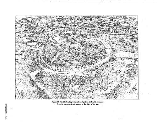
SOCIETIES GRIM'S DITCH, MONGEWELL Roadwidening of the A4074 at Ice House Hill, Mongewell, involved the destruction of a 10m length of the south Ox<strong>for</strong>dshire Grim's Ditch. Be<strong>for</strong>e destruction, excavation was conducted to ascertain, if possible, the date of the earthwork's construction. The bank survived to a height of 0.70m below the base of the modern topsoil; beneath the bank was a preconstruction ground surface with no turf line, 0.20m thick. The bank was constructed of old topsoil, covered by upcast chalk rubble from the ditch. The ditch was much disturbed by later quarrying. The base of the ditch lay 2.10m below the present ground surface. The original width was impossible to ascertain. The fill of the ditch consisted of slow silts, succeeded by a thick layer of loose chalk rubble and then more slow silt. To the rear of the bank was a roughly circular pit, c.2m in diameter. The relationship between the pit and the bank and ditch could not be determined because of later disturbances. Within the body of the bank there were three inhumations. The pottery recovered from the original ground surface, the bank and ditch was Iron Age, but the presence of the pit, which was certainly of Iron Age date, throws some doubt on whether the bank and ditch is of that date also. Radiocarbon and thermoluminescent dating can probably settle this point. JOHN HINCHLIFFE OAU EXCAVATIONS AT ASHVILLE TRADING ESTATE, MARCHAM ROAD, ABINGDON Excavations took place on this site from March to November 1974, with the help of the Abingdon and District Archaeological Society, other local societies and Unit volunteers. Initially trial trenching was carried out and later an area of c. 1500 sq.m was mechanically stripped onto the natural gravel. The majority of the features on the site were Iron Age in date, with a principal phase of activity dating from the C3 BC until the beginning of the Roman period. A few features were earlier than their main phase, dating from the C6/5 BC. No structures associated with this early activity, which is represented by a few pits, were identified. In the 3C BC a circular wooden building, c. 14m in diameter, was erected on the site (figure 13). The walls of the building stood in a construction trench up to 50cm deep and c. 80cm wide. The structure was rebuilt on two occasions, each time on a slightly different alignment. In the two later phases the hut had an entrance on the E side, represented by a causeway. The entrance area was surrounded by a fence with an entrance gap on the S side. This fence may have served as a windbreak and as a minor defensive measure. The hut had an annexe to the N, defined by a shallow ditch. A four-post structure was located inside the annexe. At a later date, probably concurrent with one of the hut rebuilding phases, the annexe was enlarged and enclosed an area of c.300 sq.m. This annexe was again defined by a ditch, slightly more substantial than the first, and had an entrance gap on the NW side. A roughly circular enclosure, defined by a ditch c.20m in diameter, was located to the NW of the hut, The enclosure had three phases of use, the ditch being recut on two occasions after the primary ditch was dug. In the two later phases the enclosure had an entrance on the SE side, opposite the hut, and may be contemporary with it. A later hut circle, comparable in size and design to the first, was cut through the enclosure ditches. Only one phase of building was recognised <strong>for</strong> this hut. In the Cl BC a substantial enclosure ditch, up to lm 80cm deep and c.2'/2m wide, was dug on the site. The ditch was on an EW alignment and had an entrance gap c.10m wide. Two sides of a less substantial enclosure ditch of c.early Cl AD date were excavated. The ditch had two entrance gaps, one by the E side of the trench and one on the SW corner of the enclosure. Several semi-complete 'Belgic' pots were recovered from the top fill of the NS leg of the ditch and sherds of imported Gaulish pottery were recovered from the EW leg of the ditch. Over a hundred pits were excavated, most of which yielded considerable amounts of pottery and bone. Large quantities of carbonised grain were recovered by sieving soil samples from the pits. One of the pits had a clay lining and may have been used <strong>for</strong> water storage. Two other pits had extensive traces of burning in them and may have been kilns. The remaining pits had, <strong>for</strong> the most part, been used to dispose of domestic rubbish, but the large quantities of carbonised grain recovered on the site in general would seem to imply that the primary purpose in digging them was <strong>for</strong> grain storage. The site is provisionally interpreted as an Iron Age farm, occupied during the C3/2 BC. The final assessment of the farm's economy must wait until the analysis of the carbonised grain and animal bones has been completed. The quantity of grain recovered from the site may indicate a bias towards crop growing rather than animal husbandry. Small finds of weaving equipment and quantities of slag recovered from the pits and ditches point to textile production and metal working, as additional factors in the farm's economy. The enclosure ditches cutting across the site indicate a changing pattern of land use in the first century BC. Roman features on the site comprised two stone-lined wells and a small number of pits, all of C4 date. In addition to these features, a salvage excavation, carried out c.100m to the S of the excavation, located a small Roman cemetery. Eleven inhumations were recorded, eight on an EW alignment and three NS. Fragments of Roman roof tile from one of the wells and the presence of the cemetery is indicative of a Roman building in the vicinity of the site. MICHAEL PARRINGTON, AEC & OAU 37