I BERINSHELD Wally Corner 1974 , ., // / / Romano <strong>British</strong> Well -- .2:".' Contractors AC.. Ro.d / . Allli / 10 f °1- 01 \ .* * 1 / 40011 - ",0' C. lf, . Clit) 2W 2iii "l0 72, all (....-, , IPo., 1 i!], 14 tl) 0 3* 3, 1 d )101 r3 I Cap A ..:z ,,,, -0,A %% 1 63 Gravel Pit Cremation El Romano-<strong>British</strong> Ditch , ec ° 7 "CD J O 110 20 30 - -- - / 4 50 0 0 0 "t i I o Figure 16
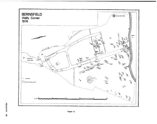
, rampart , DUCKLINGTON , wall SOCIETIES to function as a smithy and was 37m E of the main villa building. Nearby was a complex collection of postholes, possibly representing several phases of a rectangular timber building. The paddocks were divided by ditches c.2m wide and up to 0.8m deep, and in one case by a fence represented by postholes lm apart. The whole paddock complex was bounded by a droveway c.3.5m wide. In the destruction layers of the smithy were Saxon graves a rich female grave, including gilded saucer brooches and two gold and silver belt fittings with stylised animal ornament of c. mid C6. The ,second grave contained a woman with grave goods, and a newborn baby. Large quantities of Saxon material were found in the upper-most layer of the villa boundary ditch, including fragments of four bone combs and many fish and bird bones (see figure 15). To the SW of the villa was a large timber structure, possibly up to 18m long and 6m wide. The 'dating evidence <strong>for</strong> this building is inconclusive but it may possibly belong to the Saxon period. Further traces of Iron Age and early RB settlement were also located. DAVID MILES OAU EXCAVATIONS AT ALCHESTER 1974 Two 20m trenches were put through the eastern defences of the Roman town of Alchester on behalf of the Ox<strong>for</strong>dshire Archaeological Unit and the Department <strong>for</strong> External Studies of Ox<strong>for</strong>d University. The excavation was initiated to determine the extent of plough damage to the scheduled Ancient Monument (Ox<strong>for</strong>dshire no. 18), the S trench (I) being in permanent pasture, the N (II) being in arable. The sequence of occupation was the same in both trenches. The earliest features, consisting of two ditches running from N to S and of a number of pits, were of early Roman date. After the ditches had partially silted a series of occupation layers and gravel spreads were deposited on the W side of them. Overlying these two ditches were the defences of the Roman town. These consisted of a stone wall facing a dump rampart of sand and gravel tips. The wall had been robbed and only its pitched stone footings survived. In front of the was a wide berm and a wide shallow ditch, recut once. Finds from the rampart dated the defences to the late C2. Evidence of recent damage was apparent in trench II, where up to 30cms of soil had been eroded from the top of the rampart. So far this has only affected post Roman build-up of soil but continued ploughing will cause damage to the itself. CHRIS YOUNG IAM, OUDES and OAU BYPASS 1974 During November and December 1974 the Ox<strong>for</strong>dshire Archaeological Unit conducted a programme of rescue excavation on a large cropmark site previously interpreted as a RB villa, near Red Lodge, at the SE end of the Ducklington bypass. Preliminary work had been conducted by Mr G. Williams and the Witney Archaeological Group the year be<strong>for</strong>e, when field walking and a small trial trench revealed intensive occupation and a wide surface scatter of pottery. Mechanical trial trenching by the Unit revealed many ditches, pits and postholes, and evidence of occupation from Cl or early C2 to C5. Stripping of the site <strong>for</strong> further excavation was prevented by a combination of the weather and the contractors. During the course of earthmoving a Roman stone-lined well was partially excavated down to the level of the new road. Finds from this included late Roman pottery and various iron objects, including a key, a knife and a pair of shears. An isolated C7 pagan Saxon group burial was uncovered within the line of the roadway, 200m SW of Red Lodge. The grave pit, which measured approximately 1.30x1.9m, was very shallow and the inhumations lay immediately beneath the modern ploughsoil. It contained two adult inhumations and one child, all laid supine and orientated, SN, heads to the N. The remains of two bronze bound buckets, a doubleended bore point, a silver ring, a glass bead necklace, a gold ferrule and a spindle whorl were recovered. R.A. CHAMBERS OAU BERINSFIELD , WALLY CORNER A Saxon cemetery was discovered during observation of gravel extraction 1.2m N of the Roman town of Dorchester. Approximately 91 inhumations were located and four cremations (one probably Bronze Age) contained within a late RB system of enclosure ditches and fences. As many as two dozen graves may have been destroyed by gravel extraction be<strong>for</strong>e the discovery of the cemetery, and further graves probably extend under a metalled area to the W of the site. The orientation of the graves varies from SN to WE and appears to be governed by the direction of the larger RB ditches which they seem to respect. The graves contain skeletons of male and female adults and children, mostly with grave goods of the usual type; weapons, buckets, pot, beads, saucers, disc and equal armed brooches suggesting a mid C5,1ate C6 date. All graves were lacking coffins, but some were lined with charred logs and one skeleton lay on a bed of charred logs. The skeletons were mainly extended but some, noticeably lacking grave goods, were flexed. The cremations were damaged by modern activity on the site, but one had a rectangular setting of four posts around it and immediately to the N was a large funnel-shaped pit, with a female inhumation in the top layer. The lower levels contained only fragments of antler. DAVID MILES OAU 41