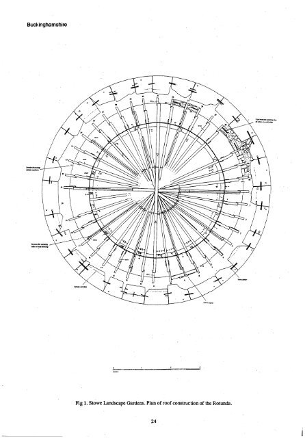
Stowe Landscape Gardens One of the great pleasures of worldng at Stowe is to witness a continually changing landscape as the task of restoring the gardens continues. The reinstatement of the 18th century paths - in 1997 in the north-west corner of the Elysian Fields - leads to new vistas and new perspectives to the landscape and its buildings. If nothing else the appearance of a major erection of scaffolding around a garden temple provides an interesting diversion to an otherwise familiar landscape. In this case the scaffolding has gone up around Vanbrugh's Rotunda on the edge of the Home Park (SP674371), as a consequence depriving the Stowe golfers of the opportunity to knock off a bit of crumbling column but compensating them with a much larger and more audible target. A watching brief was maintained whilst initial enabling works were carried out to the building, involving lifting of the steps, cleaning of the stonework and the removal of the lead roof. The domed roof has an interesting timber structure, consisting of a series of semi- circular rafters radiating out from a central crown (Fig 1). Dendrochronology provided a date of 1752 <strong>for</strong> upper part of these rafters, a date which corresponds precisely with the period of alteration to the dome between 1752-54 recorded in the Stowe accounts (Fig 2 and 3). The feet of the rafters have been repaired with new timbers which were thought to be late 19th century. Dendrochronology dating disproved this theory - they are actually about a hundred years earlier, having been cut sometime between 1779 and 1811. We can be more precise about the date when the lead sheeting of the roof was laid since a date and an inscription - 'John Turpin 1898' - were discovered etched into one of the sheets131. The recreation of the paths has revealed the usual crop of footings <strong>for</strong> missing garden structures. The position of the paths are accurately shown on the 1843 estate map and this also shows what were assumed to be three statues on the south front of the house. An attempt was made to locate the most easterly base by trial trenching with the mechanical excavator and this revealed the stump of a substantial brick wall, plus three adjoining walls <strong>for</strong>ming the sides of a small enclosure (SP676374). The position and alignment of the larger wall coincides with the position of the east wall of the 1670s ldtchen garden shown on the earliest available plan published by Sarah Bridgeman in 1739, and on subsequent plans until 1788. If it is the remains of the garden wall - and this appeals almost certain - then it represents a highly significant discovery since it allows the detail on the 1739 plan to be related to the <strong>for</strong>m of the existing landscape. The adjoining brick enclosure is thought to be the remains of a garden privy (Fig 4). The walls <strong>for</strong>m the outline of a pit slightly more than a metre in depth, the base of this pit <strong>for</strong>med of a layer of concretious lime. A number of items of rubbish were found in the pit, including a number of hand blown mould <strong>for</strong>med bottles, suggesting an early 19th century date <strong>for</strong> the deposition of this rubbish141. With the exception of the 1843 plan none of the other maps show this structure so there is a cautionary lesson to be learnt ie that the maps are selective in terms of what they portray. References 'The Annexe, Boarstall Tower, Boarstall, Building Recording and Photographic Survey' Buckinghamshire County Museum Archaeological Service Report No. 501 <strong>for</strong> the National Trust May 1997. Claydon House, Archaeological Report on Phase III and the excavations around the north, south and east fronts' Gary Marshall, September 1997. 'Stowe Landscape Gardens, Report covering the archaeological watching brief on the Rotunda' Report no. Stowe/21, Gary Marshall, March 1998. 'Stowe Landscape Gardens, Archaeological report covering the excavation of the garden wall footings in the north-west corner of the Elysian Fields - trench 179' Report no. Stowe/23, Gary Marshall, March 1998. NORTHAMPTONSHIRE ARCHAEOLOGY Gayhurst, Gayhurst Quarry (SP853446) Andy Chapman and Peter Masters Geophysical survey and trial excavation was undertaken on a known cropmark site comprising several ring ditches and rectilinear enclosures (CAS 2553), and situated on land adjacent to the M1 motorway at Gayhurst Quarry. The presence of at least four round barrows was confirmed and tluee rectilinear enclosures were shown to be Middle Iron Age in date. An extensive area of alluvial deposits appears to comprise extensive, clay-filled hollows around a single minor palaeochannel system of the River Great Ouse. Hanslope, Stocking Green Farm (SP802473) Peter Masters An earthwork survey defined the presence of closes and building plat<strong>for</strong>ms related to the <strong>for</strong>mer Medieval hamlet of Stocking Green, which had been one of several detached ends to Medieval Hanslope. A watching brief was maintained during excavation <strong>for</strong> a sewer pipe and associated balancing pond, and the exposed remains of walls, floors, yard surfaces and ditched boundaries, dating from the 12th and 13th centuries were recorded and sampled. Wing, The Old Victorian School (SP881225) Joe Prentice Buckinghamshire Trial excavation to the south of the churchyard of All Saints church located inhumation burials within graves aligned east-west and apparently arranged in ordered rows. The burials were only partly exposed and all have been left in situ. They clearly <strong>for</strong>m part of an early churchyard and confinn nineteenth century observations of burials in this area. 23
Buckinghamshire ' manes Fig 1. Stowe Landscape Gardens. Plan of roof construction of the Rotunda. 24
- Page 2 and 3: -y-efo-(A c r 1:41.0. SOUTH MIDLAND
- Page 4 and 5: BEDFORDSHIRE BEDFORDSHIRE ARCHAEOLO
- Page 6 and 7: ; , , ' 1 Bedfordshire !I I il ii i
- Page 8 and 9: The study area is historically wate
- Page 10 and 11: dwelling was of beamslot constructi
- Page 12 and 13: Bedfordshire Fig 4: Kempston Church
- Page 14 and 15: have come from the side chapel. Abu
- Page 16 and 17: Stotfold, Fairfield Hospital (TL203
- Page 18 and 19: the remains of post-Medieval/modern
- Page 20 and 21: Bedfordshire Stable Fence -1 /2====
- Page 22 and 23: The evidence from the site suggests
- Page 24 and 25: in advance of a programme of repair
- Page 28 and 29: Buckinghamshire - VI"), Fig 2. Stow
- Page 30 and 31: 566 Section along line A-13 560 Pla
- Page 32 and 33: aLlyzh 'dct_leirsmAgg Lake End Road
- Page 34 and 35: Lake End Road West In contrast to t
- Page 36 and 37: Roman Part of a limestone surface w
- Page 38 and 39: Northamptonshire 747°° 'I 7400 ed
- Page 40 and 41: Hargrave, Slade Farm (11035708) Mic
- Page 42 and 43: Northamptonshire Fig 4. Wollaston,
- Page 44 and 45: 1 - 4.:. ..,...,..,-----4..-5; 1 j
- Page 46 and 47: ''.1i.i' :::.. l':W4:15,1111111:51.
- Page 48 and 49: No structural evidence of the town
- Page 50 and 51: and it would appear that there are
- Page 52 and 53: Oxfordshire 70.84 70.90 Contours- M
- Page 55 and 56: Oxfordshire 0 300 I . . /. . 0 100
- Page 57 and 58: Oxfordshire Fig 8. Bampton, Thatche
- Page 59 and 60: Oxfordshire Segsbury Camp 97 Trench
- Page 61 and 62: Oxfordshire interest because it see
- Page 63 and 64: Oxfordshire Trench 7 This consisted
- Page 65 and 66: Oxfordshire Phase 2 - rebuilding of
- Page 67 and 68: Oxfordshire The Excavation Overall
- Page 69 and 70: Oxfordshire (See VCH). Luckily duri
- Page 71 and 72: Oxfordshire TESSERAE COUNT POTTERY
- Page 73 and 74: Oxfordshire Wykham Park Farm (SP446
- Page 75 and 76: Oxfordshire datable finds from the
- Page 77 and 78:
. Oxfordshire bank in one trench in
- Page 79 and 80:
possible. causewayed enclosure Dorn
- Page 81 and 82:
... Roman paleochannel . . w Neolit
- Page 83 and 84:
Oxfordshire scale of last year's br
- Page 85 and 86:
o o scythe/billhook former Thames c
- Page 87 and 88:
Oxfordshire Eton College funded the
- Page 89 and 90:
Oxfordshire site to known sites of
- Page 91 and 92:
Oxfordshire test pit aimed to ident
- Page 93 and 94:
Oxfordshire interpreted as Romano-B
- Page 95 and 96:
Oxfordshire 50 100 mon Fig 29. Wood
- Page 97 and 98:
graphs on pages 102 and 103 of Bast
- Page 99 and 100:
Index bracelet, Roman copper alloy
- Page 101 and 102:
Index Wellingborough, Nhants 32; Ya
- Page 103 and 104:
Index Sandford-on-Thames, Oxon 53 W
- Page 105 and 106:
Index Saxon Rhenish lava; Domey, Bu
- Page 107 and 108:
Index post-medieval: Poddington, Be