

CBA SMA\SMA 1998.PDF - Council for British Archaeology
CBA SMA\SMA 1998.PDF - Council for British Archaeology
CBA SMA\SMA 1998.PDF - Council for British Archaeology

You also want an ePaper? Increase the reach of your titles
YUMPU automatically turns print PDFs into web optimized ePapers that Google loves.
Ox<strong>for</strong>dshire<br />
Segsbury Camp 97<br />
Trench 1 Northern end<br />
Tsg)<br />
I 725i<br />
0 7763;<br />
0<br />
1761<br />
( t<br />
Nalurai<br />
75grg<br />
Named<br />
.7P73,<br />
(IOW<br />
Slams(<br />
405.100<br />
I<br />
ts1<br />
Nature..<br />
Tarn<br />
C1V o 0<br />
ri53711, n<br />
Unl<br />
MN<br />
7.2(1.<br />
MO*,<br />
105.705.7w,<br />
g<br />
406.,<br />
CEO<br />
------ \<br />
ataturaii=<br />
OEM<br />
'N<br />
ME<br />
Inas amatuas10) (<br />
4t0 720<br />
CI M127<br />
77050<br />
(ME<br />
Pastured<br />
/--) ms<br />
NOW*<br />
o ME<br />
Omg<br />
743'<br />
475.720<br />
Name!<br />
.415.115<br />
_1115.120<br />
D<br />
ME 4<br />
M<br />
N/1.81<br />
EME<br />
0 N8<br />
0 'Ns' Itsal<br />
*TM<br />
Natural<br />
i12081<br />
\ Natural<br />
j<br />
11Na:011, 420<br />
5 70 Mervin<br />
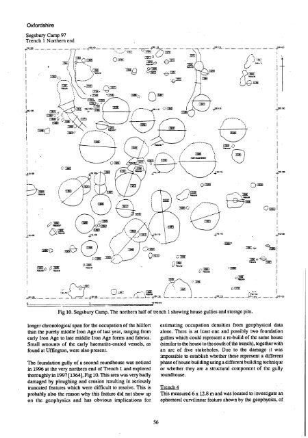
Fig 10. Segsbury Camp. The northern half of trench 1 showing house gullies and storage pits.<br />
longer chronological span <strong>for</strong> the occupation of the hill<strong>for</strong>t<br />
than the purely middle Iron Age of last year, ranging from<br />
early Iron Age to late middle Iron Age <strong>for</strong>ms and fabrics.<br />
Small amounts of the early haematite-coated vessels, as<br />
found at Uffington, were also present.<br />
The foundation gully of a second roundhouse was noticed<br />
in 1996 at the very northem end of Trench 1 and explored<br />
thoroughly in 1997 [1364], Fig 10. This area was very badly<br />
damaged by ploughing and erosion resulting in seriously<br />
truncated features which were difficult to resolve. This is<br />
probably also the reason why this feature did not show up<br />
on the geophysics and has obvious implications <strong>for</strong><br />
estimating occupation densities from geophysical data<br />
alone. There is at least one and possibly two foundation<br />
gullies which could represent a re-build of the same house<br />
(sitnilar to the house to the south of the trench), together with<br />
an arc of five stakeholes. Due to the damage it was<br />
impossible to establish whether these represent a different<br />
phase of house building using a different building technique<br />
or whether they are a structural component of the gully<br />
roundhouse.<br />
Trench 4<br />
This measured 6 x 12.8 m and was located to investigate an<br />
ephemeral curvilinear feature shown by the geophysics, of<br />
56


