

CBA SMA\SMA 1998.PDF - Council for British Archaeology
CBA SMA\SMA 1998.PDF - Council for British Archaeology
CBA SMA\SMA 1998.PDF - Council for British Archaeology

You also want an ePaper? Increase the reach of your titles
YUMPU automatically turns print PDFs into web optimized ePapers that Google loves.
Ox<strong>for</strong>dshire<br />
interest because it seemed to define the highest area of the<br />
hilltop as established by topographic survey in 1996.<br />
Excavation revealed several pits and postholes but nothing<br />
corresponding to the possible linear feature which was a<br />
very weak anomaly and could have been an artefact of the<br />
geophysics. The pottery from this trench included some<br />
Romano-<strong>British</strong> sherds (possibly early), and some stamped<br />
middle to late Iron Age types.<br />
Trench 5<br />
A trench measuring 10 x 10 m was located on a pair of very<br />
distinctive circular anomalies identified by the AML as<br />
being different to those created by storage pits. Excavation<br />
revealed two solution pipes in the chalk bedrock filled with<br />
clay with flints, similar to those found in previous years at<br />
White Horse Hill and in Trench 3 at Segsbury (Lock and<br />
Gosden 1997b; 73).<br />
One point of interest about Trench 5 was the lack of features<br />
within it, especially compared to the density within<br />
Trenches 1,4 and 2. This could represent zoning within the<br />
hill<strong>for</strong>t and suggest that the differences shown within the<br />
geophysics are real rather than being a product of overlying<br />
deposits masking features in the northern third of the<br />
interior.<br />
C1<br />
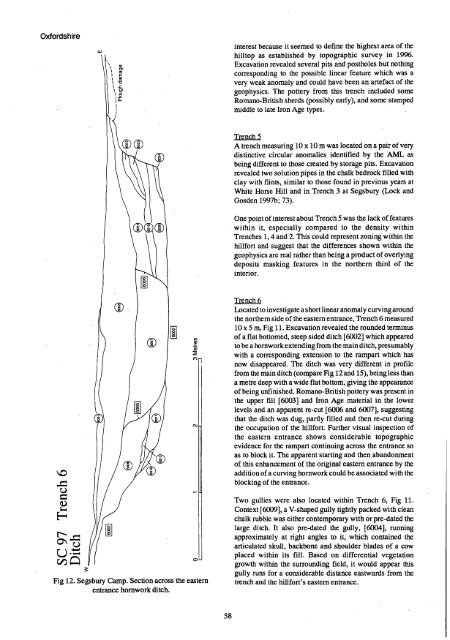
Trench 6<br />
Located to investigate a short linear anomaly curving around<br />
the northern side of the eastern entrance, Trench 6 measured<br />
10 x 5 m, Fig 11. Excavation revealed the rounded terminus<br />
of a flat bottomed, steep sided ditch [6002] which appeared<br />
to be a hornwork extending from the main ditch, presumably<br />
with a corresponding extension to the rampart which has<br />
now disappeared. The ditch was very different in profile<br />
from the main ditch (compare Fig 12 and 15), being less than<br />
a metre deep with a wide flat bottom, giving the appearance<br />
of being unfinished. Romano-<strong>British</strong> pottery was present in<br />
the upper fill [6003] and Iron Age material in the lower<br />
levels and an apparent re-cut [6006 and 6007], suggesting<br />
that the ditch was dug, partly filled and then re-cut during<br />
the occupation of the hill<strong>for</strong>t. Further visual inspection of<br />
the eastern entrance shows considerable topographic<br />
evidence <strong>for</strong> the rampart continuing across the entrance so<br />
as to block it. The apparent starting and then abandonment<br />
of this enhancement of the original eastern entrance by the<br />
addition of a curving hornwork could be associated with the<br />
blocking of the entrance.<br />
Fig 12. Segsbury Camp. Section across the eastern<br />
entrance hornwork ditch.<br />
Two gullies were also located within Trench 6, Fig 11.<br />
Context [6009], a V-shaped gully tightly packed with clean<br />
chalk rubble was either contemporary with or pre-dated the<br />
large ditch. It also pre-dated the gully, [6004], running<br />
approximately at right angles to it, which contained the<br />
articulated skull, backbone and shoulder blades of a cow<br />
placed within its fill. Based on differential vegetation<br />
growth within the surrounding field, it would appear this<br />
gully runs <strong>for</strong> a considerable distance eastwards from the<br />
trench and the hill<strong>for</strong>t's eastern entrance.<br />
58


