Task Force Report - Govind Ballabh Pant Institute of Himalayan ...
Task Force Report - Govind Ballabh Pant Institute of Himalayan ...
Task Force Report - Govind Ballabh Pant Institute of Himalayan ...

Create successful ePaper yourself
Turn your PDF publications into a flip-book with our unique Google optimized e-Paper software.
At the outset, it needs to be noted that two different<br />
sets <strong>of</strong> land statistics are available for the IHR. The<br />
first one provides information in terms <strong>of</strong> “<strong>Report</strong>ing<br />
Area”, whereas in the other set, the information<br />
is presented on the basis <strong>of</strong> total “Mapped Area”.<br />
These two different types <strong>of</strong> land use statistics at<br />
times present confusing figures. Table 2.1 depicts<br />
the summarized land use statistics for the country<br />
and the IHR. It can be seen therein that in case <strong>of</strong><br />
<strong>Report</strong>ing Area based statistics, most parts <strong>of</strong> the<br />
country (92.8% <strong>of</strong> the total geographical area) have<br />
been represented. However, the un-reported area<br />
(~7%) represents parts <strong>of</strong> the IHR only. When<br />
one looks closely, it is observed that this land use<br />
statistics reflect less than half (48%) <strong>of</strong> the total<br />
geographical area <strong>of</strong> the IHR only (Table 2.1).<br />
Incompatibility <strong>of</strong> different land use classifications<br />
poses problems in data matching. For example,<br />
culturable waste (not available for cultivation),<br />
permanent pastures and other grazing lands in<br />
the <strong>Report</strong>ing Area based classification (which<br />
describes current use status) are not represented in<br />
the map based classification.<br />
It is apparent from <strong>Report</strong>ing Area based land use<br />
classification that contrary to the general scenario<br />
in the country, where agriculture is a major<br />
land use (50.9% <strong>of</strong> the total area <strong>of</strong> the country),<br />
forests (recorded area in forest records)<br />
is the major land area in the IHR (65.4% <strong>of</strong><br />
the total reporting area <strong>of</strong> IHR; Fig. 2.1) followed<br />
by wastelands (15.7% <strong>of</strong> the area not available<br />
for cultivation and culturable wasteland), and<br />
agriculture (13.6% comprised <strong>of</strong> net area sown and<br />
current fallow).<br />
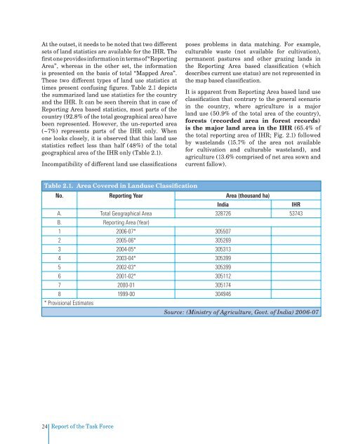
Table 2.1. Area Covered in Landuse Classification<br />
No. <strong>Report</strong>ing Year Area (thousand ha)<br />
India<br />
IHR<br />
A. Total Geographical Area 328726 53743<br />
B. <strong>Report</strong>ing Area (Year)<br />
1 2006-07* 305507<br />
2 2005-06* 305269<br />
3 2004-05* 305313<br />
4 2003-04* 305399<br />
5 2002-03* 305399<br />
6 2001-02* 305112<br />
7 2000-01 305174<br />
8 1999-00 304946<br />
* Provisional Estimates<br />
Source: (Ministry <strong>of</strong> Agriculture, Govt. <strong>of</strong> India) 2006-07<br />
24<br />
<strong>Report</strong> <strong>of</strong> the <strong>Task</strong> <strong>Force</strong>