Task Force Report - Govind Ballabh Pant Institute of Himalayan ...
Task Force Report - Govind Ballabh Pant Institute of Himalayan ...
Task Force Report - Govind Ballabh Pant Institute of Himalayan ...

Create successful ePaper yourself
Turn your PDF publications into a flip-book with our unique Google optimized e-Paper software.
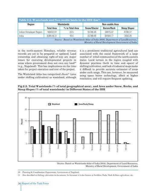
Table 2.2. Wastelands and Non-usable lands in the IHR (km 2 )<br />
Region Wastelands Non-usable Area<br />
Total Area % to Total Area Snow/Glacier Barren/Rock Steep Slopes<br />
Indian <strong>Himalayan</strong> Region 180432.91 33.5 55788.49 38415.07 4198.37<br />
India 638518.31 19.4 55788.49 64584.77 7656.29<br />
Source: Based on Wastelands Atlas <strong>of</strong> India 2000, Department <strong>of</strong> LandResources,<br />
Ministry <strong>of</strong> Rural Development Government <strong>of</strong> India<br />
in the north-eastern Himalaya, reliable revenue<br />
records are yet to be prepared or updated. Land<br />
ownership and obtaining right-<strong>of</strong>-way are major<br />
issues for executing developmental projects in<br />
areas where government does not own any land 20<br />
(e.g., Nagaland). This has implications on the time<br />
taken for project execution and cost <strong>of</strong> the project.<br />
The Wasteland Atlas has categorized Jhum 21 (area<br />
under shifting cultivation) as wasteland, although<br />
it is a prominent traditional agricultural land use<br />
associated with the social framework <strong>of</strong> a large<br />
number <strong>of</strong> tribal communities <strong>of</strong> the north-eastern<br />
states. Local terrain in the region coupled with<br />
dynamic practices (both in time and space) <strong>of</strong><br />
shifting cultivation, and lack <strong>of</strong> cadastral maps make<br />
it difficult to provide accurate estimates <strong>of</strong> areas<br />
under such usage. This can, however, be measured<br />
using space borne technology, albeit at higher<br />
resolution; and will require frequent updating.<br />
Fig.2.2. Total Wastelands (% <strong>of</strong> total geographical area), and Area under Snow, Rocks, and<br />
Steep Slopes (% <strong>of</strong> total wastelands) in Different States <strong>of</strong> the IHR<br />
80<br />
Wasteland<br />
Snow/Rocky/Steepy<br />
60<br />
Percent<br />
40<br />
20<br />
0<br />
Jammu & Kashmir<br />
Himachal Pradesh<br />
Uttarakhand<br />
Sikkim<br />
Arunachal Pradesh<br />
Meghalaya<br />
Tripura<br />
Mizoram<br />
Manipur<br />
Nagaland<br />
Assam hills<br />
WB hills<br />
Source: Based on Wastelands Atlas <strong>of</strong> India 2000, Department <strong>of</strong> Land Resources,<br />
Ministry <strong>of</strong> Rural Development, Government <strong>of</strong> India<br />
20 Planning & Coordination Department, Government <strong>of</strong> Nagaland.<br />
21 Also described as shifting cultivation in documents. In literature it is also known as Swidden, Podu, Slash & Burn agriculture, etc.<br />
26<br />
<strong>Report</strong> <strong>of</strong> the <strong>Task</strong> <strong>Force</strong>