Vision and GPS-based autonomous vehicle navigation using ...
Vision and GPS-based autonomous vehicle navigation using ...
Vision and GPS-based autonomous vehicle navigation using ...

You also want an ePaper? Increase the reach of your titles
YUMPU automatically turns print PDFs into web optimized ePapers that Google loves.
<strong>Vision</strong> <strong>and</strong> <strong>GPS</strong>-<strong>based</strong> Autonomous Vehicle Navigation<br />
Using Templates <strong>and</strong> Artificial Neural Networks<br />
Jefferson R. Souza, Gustavo Pessin, Gustavo B. Eboli, Caio C. T. Mendes,<br />
Fern<strong>and</strong>o S. Osório <strong>and</strong> Denis F. Wolf<br />
Mobile Robotics Laboratory, University of São Paulo (USP)<br />
Av. Trabalhador São-Carlense, 400 - P.O. Box 668 - 13.560-970 - São Carlos, Brazil<br />
{jrsouza, pessin, caiom, fosorio, denis}@icmc.usp.br<br />
gbuzogany@grad.icmc.usp.br<br />
ABSTRACT<br />
This paper presents a <strong>vehicle</strong> control system capable of learning<br />
to navigate <strong>autonomous</strong>ly. Our approach is <strong>based</strong> on image<br />
processing, road <strong>and</strong> navigable area identification, template<br />
matching classification for <strong>navigation</strong> control, <strong>and</strong> trajectory<br />
selection <strong>based</strong> on <strong>GPS</strong> way-points. The <strong>vehicle</strong> follows<br />
a trajectory defined by <strong>GPS</strong> points avoiding obstacles<br />
<strong>using</strong> a single monocular camera. The images obtained from<br />
the camera are classified into navigable <strong>and</strong> non-navigable<br />
regions of the environment <strong>using</strong> neural networks that control<br />
the steering <strong>and</strong> velocity of the <strong>vehicle</strong>. Several experimental<br />
tests have been carried out under different environmental<br />
conditions to evaluate the proposed techniques.<br />
Categories <strong>and</strong> Subject Descriptors<br />
I.2.9 [Artificial Intelligence]: Robotics—Autonomous Vehicles.<br />
General Terms<br />
Algorithms, Performance, Design, Experimentation.<br />
Keywords<br />
Robotic Vehicles Navigation, Compass, <strong>GPS</strong>, Trapezoidal<br />
Algorithm, Neural Networks <strong>and</strong> Urban Environments.<br />
1. INTRODUCTION<br />
Human driving errors are a major cause of car accidents on<br />
roads. These errors are caused by a series of in-car distractions,<br />
such as <strong>using</strong> mobile phones, eating while driving, or<br />
listening to loud music. Other human errors include drunk<br />
driving, speeding, <strong>and</strong> fatigue.<br />
People often get injured or even die due to road traffic<br />
collisions (RTC). Also, bad road <strong>and</strong> weather conditions<br />
Permission to make digital or hard copies of all or part of this work for<br />
personal or classroom use is granted without fee provided that copies are<br />
not made or distributed for profit or commercial advantage <strong>and</strong> that copies<br />
bear this notice <strong>and</strong> the full citation on the first page. To copy otherwise, to<br />
republish, to post on servers or to redistribute to lists, requires prior specific<br />
permission <strong>and</strong>/or a fee.<br />
SAC’12 March 25-29, 2012, Riva del Garda, Italy.<br />
Copyright 2011 ACM 978-1-4503-0857-1/12/03 ...$10.00.<br />
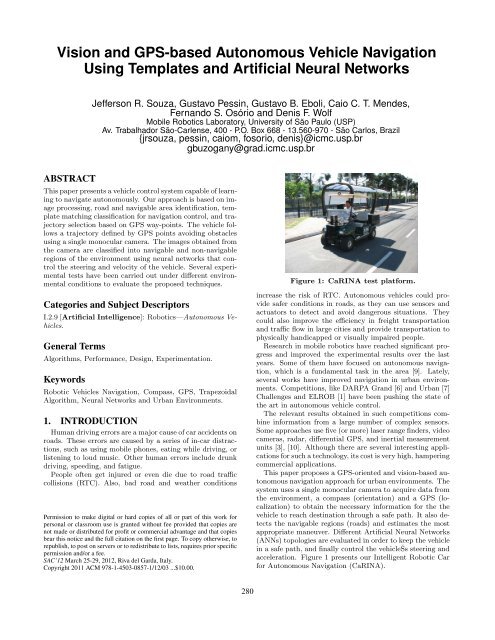
Figure 1: CaRINA test platform.<br />
increase the risk of RTC. Autonomous <strong>vehicle</strong>s could provide<br />
safer conditions in roads, as they can use sensors <strong>and</strong><br />
actuators to detect <strong>and</strong> avoid dangerous situations. They<br />
could also improve the efficiency in freight transportation<br />
<strong>and</strong> traffic flow in large cities <strong>and</strong> provide transportation to<br />
physically h<strong>and</strong>icapped or visually impaired people.<br />
Research in mobile robotics have reached significant progress<br />
<strong>and</strong> improved the experimental results over the last<br />
years. Some of them have focused on <strong>autonomous</strong> <strong>navigation</strong>,<br />
which is a fundamental task in the area [9]. Lately,<br />
several works have improved <strong>navigation</strong> in urban environments.<br />
Competitions, like DARPA Gr<strong>and</strong> [6] <strong>and</strong> Urban [7]<br />
Challenges <strong>and</strong> ELROB [1] have been pushing the state of<br />
the art in <strong>autonomous</strong> <strong>vehicle</strong> control.<br />
The relevant results obtained in such competitions combine<br />
information from a large number of complex sensors.<br />
Some approaches use five (or more) laser range finders, video<br />
cameras, radar, differential <strong>GPS</strong>, <strong>and</strong> inertial measurement<br />
units [3], [10]. Although there are several interesting applications<br />
for such a technology, its cost is very high, hampering<br />
commercial applications.<br />
This paper proposes a <strong>GPS</strong>-oriented <strong>and</strong> vision-<strong>based</strong> <strong>autonomous</strong><br />
<strong>navigation</strong> approach for urban environments. The<br />
system uses a single monocular camera to acquire data from<br />
the environment, a compass (orientation) <strong>and</strong> a <strong>GPS</strong> (localization)<br />
to obtain the necessary information for the the<br />
<strong>vehicle</strong> to reach destination through a safe path. It also detects<br />
the navigable regions (roads) <strong>and</strong> estimates the most<br />
appropriate maneuver. Different Artificial Neural Networks<br />
(ANNs) topologies are evaluated in order to keep the <strong>vehicle</strong><br />
in a safe path, <strong>and</strong> finally control the <strong>vehicle</strong>Šs steering <strong>and</strong><br />
acceleration. Figure 1 presents our Intelligent Robotic Car<br />
for Autonomous Navigation (CaRINA).<br />
280
Figure 2: General outline of the vision <strong>and</strong> <strong>GPS</strong> <strong>based</strong> <strong>autonomous</strong> <strong>navigation</strong> system.<br />
Our approach is <strong>based</strong> on two ANNs. The first identifies<br />
navigable regions <strong>using</strong> a template-<strong>based</strong> algorithm. It<br />
classifies the image <strong>and</strong> identifies the actions that should<br />
be taken by CaRINA. Images are acquired <strong>and</strong> then processed<br />
<strong>using</strong> the ANNs, which identify the road ahead of the<br />
<strong>vehicle</strong>. The value of the azimuth (difference between the<br />
current <strong>and</strong> target positions) as well as a set of values that<br />
correspond to navigable <strong>and</strong> non-navigable regions (free or<br />
obstructed) of the road is obtained. These values are used<br />
as the input of the second ANN, which aims to learn the<br />
control rules (supervised training data) for <strong>vehicle</strong> control,<br />
providing steering <strong>and</strong> velocity values. Several ANN topologies<br />
have been evaluated in order to obtain the minimum<br />
training error. The system is detailed in section 3.<br />
2. RELATED WORKS<br />
Autonomous L<strong>and</strong> Vehicle in a Neural Network (ALVINN)<br />
[11] is an ANN-<strong>based</strong> <strong>navigation</strong> system that calculates a<br />
steer angle to keep an <strong>autonomous</strong> <strong>vehicle</strong> in the road limits.<br />
The gray-scale levels of a 30 x 32 image were used as<br />
the input of an ANN. The original road image <strong>and</strong> steering<br />
were generated to improve the training, allowing ALVINN<br />
to learn how to navigate in new roads. Low resolution of<br />
a 30 x 32 image <strong>and</strong> high computational time are some of<br />
the problems found. The architecture comprises 960 input<br />
units fully connected to a hidden layer by 4 units, also fully<br />
connected to 30 units in an output layer. As this approach<br />
requires real time decisions, this topology is not efficient.<br />
281<br />
Chan et al. [2] shows an Intelligent Speed Adaptation<br />
<strong>and</strong> Steering Control that allows the <strong>vehicle</strong> to anticipate<br />
<strong>and</strong> negotiate curves safely. It uses Generic Self-Organizing<br />
Fuzzy Neural Network (GenSoFNN-Yager) which include<br />
the Yager inference scheme [8]. GenSoFNN-Yager has as<br />
feature their ability to induce from low-level information in<br />
form of fuzzy if-then rules. Results show the robustness of<br />
the system in learning from example human driving, negotiating<br />
new unseen roads. The <strong>autonomous</strong> driver demonstrates<br />
that to anticipate is not always sufficient. Moreover,<br />
large variations in the distribution of the rules were<br />
observed, which imply a high complexity of the system.<br />
Stein <strong>and</strong> Santos [18] system’s computes the steering of<br />
an <strong>autonomous</strong> robot, moving in a road-like environment.<br />
It uses ANNs to learn behaviors <strong>based</strong> on examples from<br />
a human driver, replicating <strong>and</strong> sometimes even improving<br />
human-like behaviors. To validate the created ANNs, real<br />
tests were performed <strong>and</strong> the robot successfully completed<br />
several laps of the test circuit showing good capacities for<br />
both recovery <strong>and</strong> generalization with relatively small data<br />
sets. One of the issues found is the impossibility of validating<br />
network training without testing it with the real robot.<br />
Markelic et al. [5], proposes a system that learns driving<br />
skills <strong>based</strong> on a human teacher. Driving School (DRIVSCO)<br />
is implemented as a multi-threaded, parallel CPU/GPU architecture<br />
in a real car <strong>and</strong> trained with real driving data to<br />
generate steering <strong>and</strong> acceleration control for road following.<br />
Furthermore, it uses an algorithm to detect independently-
(a) (b) (c) (d)<br />
Figure 3: Classifier structure (a), real image (b), image processing step (c) <strong>and</strong> template matching (T) (d).<br />
moving objects (IMOs) to spot obstacles with a stereo camera.<br />
A predicted action sequence is compared to the driver’s<br />
actions <strong>and</strong> a warning is issued if there are many differences<br />
between the two actions. The IMO detection algorithm is<br />
more general as it will respond not only to cars, but also to<br />
any sufficiently large (11 x 11 pixels) moving object. The<br />
steering prediction is very close to the human signal, but the<br />
acceleration is less reliable.<br />
3. PROPOSED METHOD<br />
Our approach is composed of 4 steps. In the first step<br />
an image is obtained <strong>and</strong> through ANNs another image is<br />
generated, identifying where the road (navigable region) is<br />
(Figure 3 (c)). In the second step, a template matching algorithm<br />
is used to identify the geometry of the road ahead<br />
of the <strong>vehicle</strong> (straight line, soft turn, or hard turn). In<br />
the third step, an occupation percentage is calculated to obtain<br />
the occupation areas, verifying if the road is obstructed<br />
or free <strong>based</strong> on the classified image. Finally, a supervised<br />
learning technique is used to define the action that the <strong>vehicle</strong><br />
should take to remain in the safe <strong>navigation</strong> regions<br />
(road). These steps are described in the next subsections.<br />
3.1 Image Processing Step<br />
The proposed method by Shinzato [13] was used here, as<br />
it applies ANNs to a road identification task. A system<br />
composed of six Multilayer Perceptron (MLP) ANNs was<br />
proposed to identify the navigable regions in urban environments<br />
(Figure 3 (a)). The real image can be seen on Figure<br />
3 (b). The result of this ANNs output combination is a navigability<br />
map (Figure 3 (c)). The brighter blocks represent<br />
the more likely area to be considered navigable. This step<br />
divides an image into blocks of pixels <strong>and</strong> evaluates them as<br />
single units. The advantage is that it can train the ANNs<br />
to identify different types of navigable <strong>and</strong> non-navigable<br />
regions (e.g. paved <strong>and</strong> non-paved roads, sidewalks).<br />
Initially, the image is divided into blocks of pixels, which<br />
are individually evaluated. Several features, such as pixel<br />
attributes, like RGB average, image entropy <strong>and</strong> other features<br />
obtained from this collection of pixels are calculated<br />
for each block. In the grouping step, a frame with (M xN )<br />
pixels resolution is sliced into groups with (K xK ) pixels.<br />
Suppose an image represented by a matrix I of size (M xN ).<br />
Element I(m,n) corresponds to the pixel in row m <strong>and</strong> column<br />
n of the image, where (0
3.2 Template Matching Step<br />
After obtaining the ANN classification, different road templates<br />
are placed over the image in order to identify the road<br />
geometry. One of them identifies a straight road ahead, two<br />
identify soft turns, <strong>and</strong> two identify hard turns. Each template<br />
is composed of a mask of 1s <strong>and</strong> 0s, as proposed in<br />
[17]. The value of each mask is multiplied by the correspondent<br />
value into the navigability matrix. The total score for<br />
each template is the sum of products. A good performance<br />
was obtained in the <strong>navigation</strong> defined by the urban path<br />
avoiding obstacles <strong>using</strong> the best template [16].<br />
In this step, templates are selected for use in the next step<br />
of the system. The template that obtains the higher score<br />
is selected as the best match to the road geometry.<br />
3.3 Occupation Percentage<br />
In this step, the templates of the previous step are used to<br />
calculate the occupation percentage of the road regions (navigable<br />
<strong>and</strong> non-navigable). This calculation is performed by<br />
dividing the template score by its maximum value. This is<br />
carried out for each template, so several values normalized<br />
between [0, 1] are obtained.<br />
After obtaining these values <strong>based</strong> on the occupation areas<br />
resulting from the classified images (navigable <strong>and</strong> nonnavigable<br />
- image processing step), we verify if the occupation<br />
percentage obtained is lower than a threshold level. It<br />
is then assigned as either obstructed (value 0) or free (value<br />
1) for the occupation areas, which are part of the system<br />
input for the next step.<br />
3.4 Learning Based Navigation<br />
We have already developed works analyzing different levels<br />
of memory of the templates <strong>based</strong> on examples obtained<br />
from human drivers <strong>using</strong> neural networks [15]. The results<br />
of these neural networks have also been compared with<br />
different supervised learning techniques for the same purpose<br />
[14]. This work is <strong>based</strong> in the integration of <strong>GPS</strong><br />
<strong>and</strong> compass, furthermore the occupation percentage on the<br />
<strong>autonomous</strong> <strong>navigation</strong> system.<br />
In this step, the basic network structure used is a feedforward<br />
MLP. The activation functions of the hidden neurons<br />
are logistic sigmoid <strong>and</strong> hyperbolic tangent, <strong>and</strong> the ANN<br />
learning method is the resilient backpropagation (RPROP).<br />
The inputs are represented by azimuth (difference between<br />
the current <strong>and</strong> target positions of the <strong>vehicle</strong>) <strong>and</strong> the<br />
five values obtained by the occupation percentage step (obstructed<br />
or free occupation areas). The outputs of the proposed<br />
method are the steer angle <strong>and</strong> speed (Figure 4).<br />
Figure 4: Structure of the second ANN used to generate<br />
steering <strong>and</strong> acceleration comm<strong>and</strong>s.<br />
283<br />
4. EXPERIMENTAL RESULTS<br />
The experiments were performed <strong>using</strong> CaRINA (Figure<br />
1), an electric <strong>vehicle</strong> capable of <strong>autonomous</strong> <strong>navigation</strong> in<br />
an urban road, equipped with a VIDERE DSG camera, a<br />
ROBOTEQ AX2580 motor controller for steering control, a<br />
TNT Revolution GS Compass (orientation) <strong>and</strong> a GARMIN<br />
18X-5Hz <strong>GPS</strong> (localization). The image acquisition resolution<br />
was set to (320 x 240) pixels. Figure 5 shows the <strong>vehicle</strong><br />
trajectory obtained by <strong>GPS</strong> coordinates.<br />
Figure 5: <strong>GPS</strong> coordinates performed by CaRINA.<br />
Seven <strong>GPS</strong> waypoints (desired trajectory) were defined.<br />
In order to navigate, the <strong>vehicle</strong> used a monocular camera to<br />
avoid obstacles. The experiment was successfully performed<br />
as it followed the <strong>GPS</strong> points <strong>and</strong> avoided obstacles. In some<br />
of the straight paths, the <strong>vehicle</strong> had to avoid curbs at the<br />
same time it was attracted by the <strong>GPS</strong> goal points, resulting<br />
in some oscillation in the final trajectory.<br />
Table 2 shows the values of the path performed by Ca-<br />
RINA. Five different ANNs topologies were analyzed <strong>using</strong><br />
two learning functions (logistic sigmoid <strong>and</strong> hyperbolic tangent).<br />
These topologies represent the architecture of the<br />
second ANN used in our proposed system. Several topologies<br />
of ANNs were tested to obtain the minimum training<br />
error <strong>and</strong> a near optimal neural architecture.<br />
The ANN architecture was selected considering the number<br />
of neurons in the hidden layer <strong>using</strong> the RPROP supervised<br />
learning algorithm in MLP networks <strong>and</strong> considering<br />
the values of MSE (Mean squared error) <strong>and</strong> the best epoch<br />
(Optimal point of generalization [OPG], i.e., minimum training<br />
error <strong>and</strong> maximum capacity of generalization).<br />
We also evaluated the ANNs modifying the learning functions.<br />
The main difference between these functions is that<br />
logistic sigmoid produces positive numbers between 0 <strong>and</strong> 1,<br />
<strong>and</strong> the hyperbolic tangent (HT), numbers between -1 <strong>and</strong><br />
1. Furthermore the HT is the activation function most commonly<br />
used in neural networks. After the analysis of Table<br />
2, the 6x15x2 architecture <strong>using</strong> the hyperbolic activation<br />
function showed the lowest MSE for the 10600 epoch. Five<br />
different runs were executed changing the r<strong>and</strong>om seed used<br />
in the neural networks (Tests 1 to 5).<br />
Figure 6 shows the histograms of the errors <strong>based</strong> on the<br />
best ANN topology obtained in Table 2. Topologies 4 <strong>and</strong><br />
5 were accepted <strong>based</strong> on the results. Figure 6(b) presents<br />
the error concentrated on zero <strong>and</strong> with a lower dispersion<br />
than the one in Figure 6(a). The same is true for Figure<br />
6(d), which shows a lower dispersion compared to Figure<br />
6(c), therefore encouraging the use of topology 5.
Table 2: Results of the ANNs for each topology.<br />
Learning Functions<br />
Logistic Sigmoid<br />
Hyperbolic Tangent<br />
ANN Topology Test 1 Test 2 Test 3 Test 4 Test 5 Test 1 Test 2 Test 3 Test 4 Test 5<br />
6x3x2 OGP 600 3000 1400 700 1000 1400 2300 1000 2000 2600<br />
Topology 1 MSE (10 −3 ) 5.266 3.922 3.747 5.407 4.856 4.119 3.418 3.737 3.393 3.310<br />
6x6x2 OGP 7600 1200 8300 1700 5600 2200 700 1900 9700 26400<br />
Topology 2 MSE (10 −3 ) 2.490 3.257 3.250 3.670 3.414 3.271 3.413 2.148 5.404 3.217<br />
6x9x2 OGP 800 600 500 900 2300 1100 1100 800 800 400<br />
Topology 3 MSE (10 −3 ) 3.774 5.013 4.584 5.050 3.190 3.162 3.318 3.650 2.352 4.292<br />
6x12x2 OGP 91800 15200 1000 23600 1400 400 1400 800 300 7400<br />
Topology 4 MSE (10 −3 ) 2.836 3.797 3.746 2.048 5.645 4.040 3.899 2.959 3.595 3.895<br />
6x15x2 OGP 400 600 1300 400 700 2600 76100 10600 2500 1000<br />
Topology 5 MSE (10 −3 ) 4.226 4.597 4.000 5.319 3.188 3.232 1.999 1.881 3.510 2.989<br />
The statistical difference of the results was evaluated <strong>using</strong><br />
Shapiro method [12]. We observed that the null hypothesis,<br />
i.e., normal adequacy, had not been satisfied (Table 3) <strong>using</strong><br />
the best ANN topology (6x15x2) for the test data.<br />
Table 3: Results of the Shapiro-Wilk Test.<br />
Shapiro-Wilk Normality Test<br />
p-value<br />
Steering Velocity<br />
Topology 1 0.2468 3.84e-09<br />
Topology 2 5.43e-14 1.97e-15<br />
Topology 3 6.81e-14 2.68e-15<br />
Topology 4 6.69e-13 8.60e-15<br />
Topology 5 2.20e-16 1.59e-15<br />
Value in boldface - Accepted as normal<br />
Other values - Not accepted as normal<br />
The Man-Whitney method [4] was used to check the differences<br />
between the topologies (see Table 4). For the velocity,<br />
the method does not reject the null hypothesis (equality)<br />
(the p-values are higher than 0.05) <strong>and</strong> for the steering, the<br />
null hypothesis (equality) is rejected only between topologies<br />
(T) 1 <strong>and</strong> 5 (the p-values are lower than 0.05). According to<br />
this statistical method <strong>and</strong> <strong>using</strong> a confidence level of 95%,<br />
there is no evidence of statistical differences between the<br />
best results, except for T1 <strong>and</strong> T5 concerning the steering.<br />
Table 4: Results of the Man/Whitney Test.<br />
Man/Whitney Test<br />
p-value<br />
T1 T2 T3 T4<br />
Steering T5 0.031 0.115 0.397 0.114<br />
Velocity T5 0.464 0.403 0.715 0.585<br />
Figures 7 <strong>and</strong> 8 illustrate the steering angle <strong>and</strong> velocity of<br />
CaRINA <strong>using</strong> the 6x15x2 architecture (Test 3 HT), showing<br />
the values <strong>based</strong> on the control rules (supervised training<br />
data) <strong>and</strong> the results obtained by the learning of the ANN.<br />
Small oscillations are present in the data learned by the<br />
ANN, since the original control rules maintained the steering<br />
wheel <strong>and</strong> velocity constant, resulting in the linearity of data<br />
(the only problem for the ANN was to learn a rigid curve <strong>and</strong><br />
high velocity, but this fact did not interfere in the results).<br />
CaRINA was able to navigate <strong>autonomous</strong>ly in an urban<br />
road safely; it did not get too close to the sidewalk (nonnavigable<br />
areas) <strong>and</strong> tracked the <strong>GPS</strong> points (way-point)<br />
provided to the system.<br />
284<br />
5. CONCLUSION AND FUTURE WORKS<br />
Autonomous <strong>vehicle</strong> <strong>navigation</strong> is a fundamental task in<br />
mobile robotics. This paper has showed a <strong>GPS</strong> oriented<br />
vision-<strong>based</strong> <strong>autonomous</strong> <strong>navigation</strong> system that can be trained<br />
to identify the road <strong>and</strong> navigable regions <strong>using</strong> ANNs,<br />
template matching classification, occupation percentage <strong>and</strong><br />
learning <strong>based</strong> <strong>navigation</strong>. Our approach was evaluated <strong>using</strong><br />
CaRINA in urban road. CaRINA was able to navigate<br />
<strong>autonomous</strong>ly in this environment, successfully following the<br />
desired trajectory. Our quantitative analysis also obtained<br />
satisfactory results for the different ANNs topologies.<br />
As future work, we plan to evaluate other classification<br />
methods <strong>and</strong> decision making algorithms. We also are planning<br />
to integrate camera <strong>and</strong> LIDAR in order to deal with<br />
bumps <strong>and</strong> depressions in the road.<br />
6. ACKNOWLEDGMENTS<br />
The authors acknowledge the support granted by CNPq<br />
<strong>and</strong> FAPESP to the INCT-SEC (National Institute of Science<br />
<strong>and</strong> Technology - Critical Embedded Systems - Brazil),<br />
<strong>and</strong> FAPESP doctoral grant (process 2009/11614-4).<br />
7. REFERENCES<br />
[1] European l<strong>and</strong>-robot (elrob), 2011.<br />
http://www.elrob.org/, Access on 26 Aug.<br />
[2] M. Chan, D. Partouche, <strong>and</strong> M. Pasquier. An<br />
intelligent driving system for automatically<br />
anticipating <strong>and</strong> negotiating road curves. Int. Conf. on<br />
Intelligent Robots <strong>and</strong> Systems, pages 117–122, 2007.<br />
[3] H. Dahlkamp, A. Kaehler, D. Stavens, S. Thrun, <strong>and</strong><br />
G. Bradski. Self-supervised monocular road detection<br />
in desert terrain. In G. Sukhatme, S. Schaal,<br />
W. Burgard, <strong>and</strong> D. Fox, editors, In RSS, 2006.<br />
[4] M. P. Fay <strong>and</strong> M. A. Proschan.<br />
Wilcoxon-mann-whitney or t-test? on assumptions for<br />
hypothesis tests <strong>and</strong> multiple interpretations of<br />
decision rules. Statistics Surveys, 4:1–39, 2010.<br />
[5] I. Markelic, A. Kjaer-Nielsen, K. Pauwels, L. B. W.<br />
Jensen, N. Chumerin, A. Vidugiriene,<br />
M. Tamosiunaite, A. Rotter, M. V. Hulle, N. Kruger,<br />
<strong>and</strong> F. Worgotter. The driving school system:<br />
Learning automated basic driving skills from a teacher<br />
in a real car. Trans. on Intell. Transp. Systems, 2011.<br />
[6] B. Martin, I. Karl, <strong>and</strong> S. Sanjiv. The 2005 DARPA<br />
Gr<strong>and</strong> Challenge, volume 36. Springer Tracts in<br />
Advanced Robotics, 2007.
(a) Steering of topology 4 (Test 4 LS)<br />
Figure 7: Steering wheel <strong>using</strong> the test data.<br />
(b) Steering of topology 5 (Test 3 HT)<br />
(c) Velocity of topology 4 (Test 4 LS)<br />
(d) Velocity of topology 5 (Test 3 HT)<br />
Figure 6: Error histogram considering different hidden<br />
layers of the best ANNs (MSE = 2.048 [topology<br />
4] <strong>and</strong> MSE = 1.881 [topology 5]) (a) <strong>using</strong> steering<br />
angle data of topology 4 (logistic sigmoid [LS]), (b)<br />
steering angle data of topology 5 (hyperbolic tangent<br />
[HT]), (c) velocity data of topology 4, <strong>and</strong> (d)<br />
velocity of topology 5. The x axis shows the error.<br />
[7] B. Martin, I. Karl, <strong>and</strong> S. Sanjiv. The DARPA Urban<br />
Challenge, volume 56. Springer Tracts in Advanced<br />
Robotics, 2010.<br />
[8] R. J. Oentaryo <strong>and</strong> M. Pasquier. Gensofnn-yager: A<br />
novel hippocampus-like learning memory system<br />
realizing yager inference. In IJCNN, pages 1684–1691.<br />
285<br />
Figure 8: Velocity <strong>using</strong> the test data.<br />
[9] A. Petrovskaya <strong>and</strong> S. Thrun. Model <strong>based</strong> <strong>vehicle</strong><br />
detection <strong>and</strong> tracking for <strong>autonomous</strong> urban driving.<br />
Autonomous Robots Journal, 26(2-3):123–139, 2009.<br />
[10] A. Petrovskaya <strong>and</strong> S. Thrun. Model <strong>based</strong> <strong>vehicle</strong><br />
tracking in urban environments. IEEE ICRA, 2009.<br />
[11] D. A. Pomerleau. ALVINN: An Autonomous L<strong>and</strong><br />
Vehicle In a Neural Network. Advances In Neural<br />
Information Processing Systems, 1989.<br />
[12] S. S. Shapiro <strong>and</strong> M. B. Wilk. An analysis of variance<br />
test for normality (complete samples). Biometrika,<br />
52(3–4):591–611, 1965.<br />
[13] P. Y. Shinzato <strong>and</strong> D. F. Wolf. A road following<br />
approach <strong>using</strong> artificial neural networks<br />
combinations. Journal of Intelligent <strong>and</strong> Robotic<br />
Systems, 62(3):527–546, 2010.<br />
[14] J. R. Souza, G. Pessin, F. S. Osório, <strong>and</strong> D. F. Wolf.<br />
<strong>Vision</strong>-<strong>based</strong> <strong>autonomous</strong> <strong>navigation</strong> <strong>using</strong> supervised<br />
learning techniques. In 12th Engineering Applications<br />
of Neural Networks (EANN’11), 2011.<br />
[15] J. R. Souza, G. Pessin, P. Y. Shinzato, F. S. Osório,<br />
<strong>and</strong> D. F. Wolf. <strong>Vision</strong>-<strong>based</strong> <strong>autonomous</strong> <strong>navigation</strong><br />
<strong>using</strong> neural networks <strong>and</strong> templates in urban<br />
environments. First Brazilian Conference on Critical<br />
Embedded Systems (I CBSEC), pages 55–60, 2011.<br />
[16] J. R. Souza, D. O. Sales, P. Y. Shinzato, F. S. Osório,<br />
<strong>and</strong> D. F. Wolf. Template-<strong>based</strong> <strong>autonomous</strong><br />
<strong>navigation</strong> <strong>and</strong> obstacle avoidance in urban<br />
environments. SIGAPP - Applied Comp. Rev., 2011.<br />
[17] J. R. Souza, D. O. Sales, P. Y. Shinzato, F. S. Osório,<br />
<strong>and</strong> D. F. Wolf. Template-<strong>based</strong> <strong>autonomous</strong><br />
<strong>navigation</strong> in urban environments. In 26th ACM<br />
Symp. on Applied Computing, pages 1376–1381, 2011.<br />
[18] P. S. Stein <strong>and</strong> V. Santos. Visual guidance of an<br />
<strong>autonomous</strong> robot <strong>using</strong> machine learning. 7th IFAC<br />
Symposium on Intelligent Autonomous Vehicles, 2010.