download - Wavelength Paddling Magazine
download - Wavelength Paddling Magazine
download - Wavelength Paddling Magazine

Create successful ePaper yourself
Turn your PDF publications into a flip-book with our unique Google optimized e-Paper software.
Kayak Navigation<br />
The Basics<br />
by Adam Bolonsky<br />
At its most basic, kayak navigation<br />
boils down to a handful of skills<br />
most anyone can learn in a day or<br />
two. To begin, you’ll need a chart, preferably of<br />
a place you like to paddle or one you’re thinking<br />
of exploring, a deck-mounted or hand-held<br />
compass, a sharp pair of eyes and a course-plotting<br />
tool.<br />
Charts<br />
Published by the National Oceanic and<br />
Atmospheric Administration (NOA A) in the<br />
US and the Canadian Hydrographic Service<br />
in Canada, charts come in a variety of sizes that<br />
range from gorgeous 46” x 44” to 11” x 23” government<br />
printings that contain a deep level of<br />
detail (they make beautiful wall hangings) to<br />
11”x17” commercial reproductions, printed in<br />
folio form at somewhat lower levels of resolution,<br />
yet with no less detail, available from outfits<br />
like MapTech.<br />
Important to remember about charts is that<br />
they are drawn in a variety of scales and offer<br />
different levels of detail. They always include a<br />
distance and latitude scale and, no matter their<br />
size, always include the names of islands, capes,<br />
peninsulas, etc., as well as the color and number<br />
of navigational buoys. Just keep in mind that<br />
no matter what scale the chart, one minute of<br />
latitude (a chart’s horizontal increment) equals<br />
one nautical mile—or about the distance an average<br />
paddler can cover in 15 minutes or so.<br />
You can purchase government-issue charts<br />
from any full-service marine supplier in numbered<br />
series for around $18 each. Also you can<br />
<strong>download</strong> and print them yourself or have a<br />
designated reseller print them for you. They’re<br />
also available on cd-rom or in regional portfolios<br />
from any number of commercial publishing<br />
concerns. With practice, their startling wealth<br />
of information and high levels of detail can be<br />
read in just a few moments. The key is to learn<br />
a few symbols.<br />
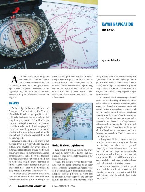
Rocks, Shallows, Lighthouses<br />
Take a look at the detail section of a chart,<br />
showing the outer wilds of Boston Harbor, a<br />
place as good as any to look for adventure a few<br />
miles from home.<br />
Among the excerpt’s myriad details, you’ll<br />
note that the excerpt indicates all of outer<br />
Boston Harbor’s significant submerged rocks,<br />
each of its islands, all of its sandbars and shoals.<br />
Digging a little deeper, you’ll also find that<br />
it describes the topography of the Brewster<br />
Islands: the nature of their shoreline (rocky,<br />
sandy, boulder-strewn, etc.); their wrecks; their<br />
lighthouses (two) and the wide range of navigational<br />
buoys which surround them (about a<br />
dozen). The excerpt also shows the major shipping<br />
channel, The South Channel, where the<br />
length of football fields slip by at speeds of eight<br />
knots or more.<br />
To depict the wealth of meaning and detail,<br />
charts use a wide variety of numerals, letters,<br />
colors and codes. Outer Brewster Island, for example,<br />
is 60 feet tall in its southeast corner and<br />
rises to 103 feet at an overlook. It sports a sandspit<br />
that snakes out of the island’s southwest<br />
corner for nearly a mile. Great Brewster also<br />
has a wharf on its southwestern shore and is<br />
surrounded by a deep thicket of large boulders.<br />
Where would you choose to land if you wanted<br />
to explore Great or Outer Brewster? Now have<br />
a look at The Graves to the northeast and Little<br />
Brewster to the southeast. You’ll note that each<br />
has a lighthouse.<br />
A chart graphically describes everything you<br />
can expect to encounter when you paddle within<br />
its territory: channel markers, navigational<br />
buoys, lighthouses, wharves, wrecks, shoreline<br />
contours, beach slopes, etc.—landmarks<br />
and features which will help you keep track of<br />
where you are. The chart will likewise help you<br />
assess good places to duck out of bad weather or<br />
hunker down in a tent to wait out a storm.<br />
Take a few moments to review the excerpt<br />
more carefully. You’ll note a code printed<br />
beneath the lavender exclamation point that<br />
marks Graves Light (the outer harbor’s northeast<br />
corner):<br />
42 WaveLength <strong>Magazine</strong> july–september 2008