download - WaveLength Paddling Magazine
download - WaveLength Paddling Magazine
download - WaveLength Paddling Magazine

Create successful ePaper yourself
Turn your PDF publications into a flip-book with our unique Google optimized e-Paper software.
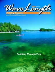
Mothership Meandering<br />
Separation Anxiety<br />
Queen Charlotte Strait is the name of<br />
the body of water where Vancouver<br />
Island diverges from the Mainland of British<br />
Columbia just north of Johnstone Strait.<br />
This is not to be confused with the strait<br />
bounding the Queen<br />
Charlotte Islands<br />
well to the north of<br />
here—Hecate Strait,<br />
aptly named after the<br />
Greek goddess of the<br />
underworld.<br />
W h i l e Q u e e n<br />
Charlotte Strait can<br />
also be a hellion at<br />
times, in calmer conditions you can safely<br />
enjoy the many weather-beaten islets<br />
fringing its eastern side.<br />
I remember one trip, blessed with early<br />
calm, as we explored this fringe of islets:<br />
me standing on top of the wheelhouse<br />
watching for rocks and scanning for future<br />
paddling spots; Laurie below, steering while<br />
delighting in the many scoters and auklets<br />
we were passing.<br />
As that morning wound on, however, the<br />
wind started to blow up to the point that<br />
we finally abandoned our northwesterly<br />
progress and ducked into Wells Passage<br />
where we were protected from the now<br />
rough waters of Queen Charlotte Strait.<br />
Wells Passage is an entryway to a veritable<br />
maze of inner waterways—Grappler Sound,<br />
Kenneth Passage, Mackenzie Sound, Nepah<br />
Lagoon...<br />
Early morning is a magical<br />
time for paddling. It’s usually<br />
still and you feel wonderfully<br />
at peace as your bow slips<br />
through the mirroring waters,<br />
the shore’s reflections<br />
multiplying in your wake.<br />
With so many protected bays and<br />
lagoons in which to anchor, where should<br />
we go? Scanning our guidebooks, we<br />
noticed that nearby Drury Inlet had a<br />
cluster of rocks and islets at its head, exactly<br />
the sort of formation<br />
in which we love to<br />
paddle. There was also<br />
an interesting looking<br />
offshoot into Actaeon<br />
Sound leading to an<br />
inner lagoon—lots to<br />
explore by kayak!<br />
Since our tide and<br />
current tables showed<br />
that slack water was just ending at the entry<br />
to Drury, we decided to go for it.<br />
With the help of our guidebook, we<br />
navigated past the hazards at the narrowest<br />
part of Stuart Narrows and proceeded west<br />
up the Inlet, finding it to be a considerable<br />
body of water. The low surrounding land<br />
was forested with second growth timber<br />
as it had obviously been heavily logged<br />
over the years, and some recent logging<br />
scars caught the eye. Perhaps this feature,<br />
and the fact there are so many other<br />
good anchorages nearby, kept Drury from<br />
becoming popular with boaters—certainly<br />
we saw few boats here.<br />
Reaching the Muirhead Islands near the<br />
head of the Inlet, we found a small notch<br />
where we dropped anchor. I launched the<br />
kayaks off the side as Laurie readied our<br />
paddles and gear. ➝<br />
Story and photo<br />
by Alan Wilson<br />
New • Demos • Rentals<br />
Seaward Kayaks<br />
Wilderness Systems<br />
Nova Craft Canoes<br />
Ocean Kayaks<br />
Tents & Gear<br />
Seasonal Warehouse<br />
Call 604 715-7174<br />
June/July 2004 www.<strong>WaveLength</strong><strong>Magazine</strong>.com<br />
25