Preliminary environmental constraints analysis - Arrow Energy
Preliminary environmental constraints analysis - Arrow Energy
Preliminary environmental constraints analysis - Arrow Energy
You also want an ePaper? Increase the reach of your titles
YUMPU automatically turns print PDFs into web optimized ePapers that Google loves.
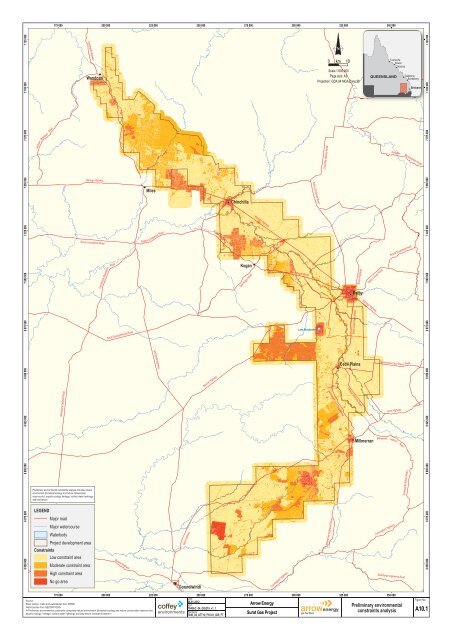
7 095 000 7 100 0007 105 000 7 110 000 7 115 000 7 120 000 7 125 000 7 130 000 7 135 000 7 140 000Pigott Road195 000 200 000 205 000 210 000 215 000 220 000 225 000 230 000 235 000 240 000 245 000 250 000 255 000 260 000 265 000Auburn RoadPonty Pool RoadLEGENDTwelve Mile RoadCommers RoadRoadRailwayWatercourseProject development areaNumber Seven RoadBig Valley Road<strong>Preliminary</strong> <strong>environmental</strong> <strong>constraints</strong> <strong>analysis</strong> includes naturalenvironment (terrestrial ecology and nature conservationreserves etc), aquatic ecology, heritage, surface water hydrologyand land tenureAuburn RoadBocks RoadNumber Five RoadKnudsens RoadNathan RoadBungaban RoadNumber Four RoadShacho RoadNumber Two RoadWalshs RoadGlendoan RoadCanns RoadRoche Creek RoadForestry RoadMaintop RoadZilmans RoadDillons RoadTip RoadPolsons RoadDascombes RoadNelders RoadWandoanConstraintsLow constraint areaModerate constraint areaHigh constraint areaNo go areaNominal separation distance from residencesJefferys RoadMiddle Creek RoadGreaves RoadLeichhaRoadt HighwayKnights RoadPeakes RoadHookswood Pelham Road7 095 000 7 100 000 7 105 000 7 110 000 7 115 000 7 120 000 7 125 000 7 130 000 7 135 000 7 140 000dOld Chinchilla RoadBurunga LDownfall Creek RoadCormacks RoadFosters RoadHansens RoadUpper Downfall Creek RoadGulugubaN0 km 5Scale 1:200,000Page size: A3Projection: GDA 1994 MGA Zone 5612 3Figure No:4 5A10.2678 9195 000 200 000 205 000 210 000 215 000 220 000 225 000 230 000 235 000 240 000 245 000 250 000 255 000 260 000 265 000Date:Source:25.01.2012Place names, roads and waterbodies from DERM.MXT:Watercourses from GEODATA250k.7040AC_04_GIS208_v1_17040_04_ATT10_F10.02_GIS_FTSurat Gas Project<strong>Arrow</strong> <strong>Energy</strong> <strong>Preliminary</strong> <strong>environmental</strong><strong>constraints</strong> <strong>analysis</strong>Map 1 of 9
Diamondy Road270 000 275 000 280 000 285 000 290 000 295 000 300 000 305 000 310 000 315 000 320 000 325 000 330 000 335 000 340 000 345 000NobbsStaines RoadTingoora RoadBourkes RoadSmiths RoadOld Burrandowan RoadV Bells RoadDelger RoadOne Thirty RoadJua RoadAuburn RoadErlichs RoadAlcocks RoadHoares RoadForest RoadBurra Burri RoadPelican Lagoons RoadBurraburri Creek RoadNudley School RoadMillingwood RoadDavies RoadChinchilla Burncluith RoadIronpot RoadJandowae Durah RoadBells RoadG Blowers RoadBurncluith School RoadBob Rennicks RoadR Blowers RoadDiamondy RoadPit RoadProctors RoadBurncluith RoadBayliss RoadSarum RoadCurds RoadWiddons RoadJolimont RoadButts RoadJarail RoadSullivans RoadStubbs Armstrong RoadMclean RoadWoltmanns RoadPaines RoadSwains RoadMcphee RoadCoverty RoadFairyland School RoadBassingthwaightes RoadHoares Boundary RoadW Gores RoadBarnes RoadRussells RoadBurra Burri Darr Creek RoadMilky Way RoadRennicks RoadBraithwaites RoadMt Pipe Dodge RoadBuddens RoadNudley Forest RoadKoehlers RoadWoods RoadWolletts RoadWellcamp LJinghi Gully RoadGadsbys RoadOld Rosevale RoadPelican Back RoadHolmes RoadGrundys RoadLanglands Hall RoadJinghi RoadWoolletts RoadT Atkin RoadDalzells RoadQuiet Glen RoadRidge RoadMoran Creek RoadCarlishs RoadD Atkins RoadLanglands RoadWarra Canaga Creek RoadEhlma Boundary RoadSengs RoadBraziers RoadAngle RoadSargents RoadOlsens RoadHartwigs RoadShillings RoadAberdeen AvArthurs LEhrlichs RoadBenjamins RoadCockatoo Ridge RoadR Dickmans RoadCases RoadNiagra RoadLittleprouds RoadStaines RoadWoolletts RoadBurraburri Creek RoadAberdeen AvChandlers RoadButts RoadChinchilla Wondai RoadKingaroy Burrandowan RoadSullivans RoadWiddons RoadMundubbera Durong RoadBurnduithPelicanFairylandJandowae Connection RoadCanagaBurra BurriDarr CreekDurong7 045 000 7 050 000 7 055 000 7 060 000 7 065 000 7 070 000 7 075 000 7 080 000 7 085 000 7 090 0007 045 000 7 050 0007 055 000 7 060 000 7 065 000 7 070 000 7 075 000 7 080 000 7 085 000 7 090 000LEGENDRoadWatercourseProject development area<strong>Preliminary</strong> <strong>environmental</strong> <strong>constraints</strong> <strong>analysis</strong> includes naturalenvironment (terrestrial ecology and nature conservationreserves etc), aquatic ecology, heritage, surface water hydrologyand land tenureConstraintsLow constraint areaModerate constraint areaHigh constraint areaNo go areaNominal separation distance from residences0 km 5Sturgess RoadStankes RoadMcintyres RoadColls RoadOak Park Road270 000 Map 3 of 9275 000 280 000 285 000 290 000 295 000 300 000 305 000 310 000 315 000 320 000 325 000 330 000 335 000 340 000 345 000Date:Figure No:Source:25.01.2012Place names, roads and waterbodies from DERM.MXT:<strong>Arrow</strong> <strong>Energy</strong> <strong>Preliminary</strong> <strong>environmental</strong><strong>constraints</strong> <strong>analysis</strong>Watercourses from GEODATA250k.7040AC_04_GIS208_v1_17040_04_ATT10_F10.04_GIS_FTSurat Gas Project1NScale 1:200,000Page size: A3Projection: GDA 1994 MGA Zone 562 34 5678 9A10.4
Fortune Dr195 000 200 000 205 000 210 000 215 000 220 000 225 000 230 000 235 000 240 000 245 000 250 000 255 000 260 000 265 000Clarks RoadScoullers RoadRyans RoadBaking Board RoadWilliams RoadFreemans RoadThe Peak RoadDrillham Road SFairymeadow RoadGreenswamp RoadHarphams RoadAvenue RoadHenrys RoadChinchilla Kogan RoadClynes RoadArubialRedmarley RoadMontrose RoadWeiambilla RoadBennett School RoadBarramornie RoadMary RoadSunnyside RoadWeranga Road NTimothy RoadLucky RoadUpper Humbug RoadMccaskers RoadWeitzels RoadSouth RoadJoseph RoadBakers RoadMyra RoadStaines RoadBests RoadLebsanfts RoadSheriffs RoadCameby RoadYellowstone RoadButlers Extension RoadButlers RoadArchers Cross RoadHubbards RoadParadise RoadPhipps RoadWains RoadDrildool RoadOrchard RoadSuttons RoadSherwood RoadMcnulty RoadTames RoadThames RoadChilds RoadWindmill RoadGoombi Fairymeadow RoadWebers RoadMclennans RoadHopelands School RoadKentara RoadDohertys RoadSunnyglen RoadGlenolive RoadQuires RoadThompsons RoadFletts RoadFletts Road WN E Robinsons RoadKummerows RoadVanrenans RoadVan Renans RoadElerslea LDougalls RoadElerslea L ENelgai RoadRavens RoadChurch RoadEmu PdeBlackburns RoadCharles DrGolden Glow RoadKytes RoadTreasures RoadWerona RoadTerese RoadRobbos RoadHappiness RoadButterfly RoadBellbird RoadBillabong LTomalou LWinfield RoadKookaburra DrChristopher RoadBarramornie Road ECrystal Creek RoadWest Valley RoadMachaness RoadTolmah CtAlkira LGazzards RoadNothurfts RoadHubbards RoadChurch RoadVanrenans RoadButlers RoadBartels RoadMales DrMales RoadHumbug RoadWilson RoadButlers RoadLeichhardt HighwayHopelandChinchilla Road SouthCondamine Kogan RoadKogan-Condamine RoadKogan-Condamine RoadRomaCondamine ne RoadCondamineChinchillaElerslea LLeichhardt HighwayCondamine Meandarra Road6 995 000 7 000 000 7 005 000 7 010 000 7 015 000 7 020 000 7 025 000 7 030 000 7 035 000 7 040 0006 995 000 7 000 000 7 005 000 7 010 000 7 015 000 7 020 000 7 025 000 7 030 000 7 035 000 7 040 000LEGEND1RoadRailwayWatercourseProject development area<strong>Preliminary</strong> <strong>environmental</strong> <strong>constraints</strong> <strong>analysis</strong> includes naturalenvironment (terrestrial ecology and nature conservationreserves etc), aquatic ecology, heritage, surface water hydrologyand land tenure2 34 5678 9N0 km 5Tara Kogan RoadScale 1:200,000Page size: A3Projection: GDA 1994 MGA Zone 56ConstraintsLow constraint areaModerate constraint areaHigh constraint areaNo go areaNominal separation distance from residences195 000 200 000 205 000 210 000 215 000 220 000 225 000 230 000 235 000 240 000 245 000 250 000 255 000 260 000 265 000Date:Source:25.01.2012Place names, roads and waterbodies from DERM.MXT:Watercourses from GEODATA250k.7040AC_04_GIS208_v1_17040_04_ATT10_F10.05_GIS_FTSurat Gas Project<strong>Arrow</strong> <strong>Energy</strong> <strong>Preliminary</strong> <strong>environmental</strong><strong>constraints</strong> <strong>analysis</strong>Map 4 of 9Figure No:A10.5
270 000 275 000 280 000 285 000 290 000 295 000 300 000 305 000 310 000 315 000 320 000 325 000 330 000 335 000 340 000 345 000Lower Jinighi RoadWychie RoadWinfields RoadCollins RoadChances Plain RoadCrowles RoadBoiling Springs RoadGorge RoadBushgrove School RoadSkinners RoadD Mcintyres RoadInverai RoadHaystack RoadCox RoadOak Park RoadEhlma Boundary RoadJeitzs RoadCarlishs RoadSchloss RoadInverai Kate Plain RoadB Riders RoadNine Mile Stock Route RoadMullers RoadTuckerang RoadLyndley LDonalds RoadDavisons RoadRadkes RoadDundonald RoadMcivers RoadCols RoadWegners RoadNorbell RoadCedarvale RoadWintons RoadMclarens RoadKents RoadJandowae Macalister RoadLogie RoadBeelbee RoadWarra Canaga Creek RoadKleidons RoadWolskis RoadWarra Marnhull RoadHealys Cross RoadSixteen Mile Hall Road Hartwigs RoadBidstrups RoadFletchers RoadFreers RoadBoonara Invern RoadA Mcintyres RoadAstburys RoadInverai Belah RoadLyndley Connection Jandowae RoadHickrys RoadJan Gharm RoadHickeys RoadHaystack Road NJones RoadPrices RoadWhyalla RoadSeigmeiers RoadCoopers RoadNauschutzs RoadTylers RoadBunya HighwayKerswells RoadHealys RoadJusts RoadWilliams RoadBools RoadSmiths RoadJimbour Station RoadAlexanders RoadWeirs RoadDavis RoadEldens RoadWarrego HighwayChinchilla Kogan RoadOlms RoadQuires RoadQuigleys LMatthews RoadTaylors RoadInglenton Frees RoadMacalister Pirrinuan RoadMalakoff Kaimkillenbun RoadPirrinuan Apunyal RoadBanana Bridge RoadLillingstone RoadKaringal Apunyal RoadDaandine RoadYoungs RoadGrahams RoadKerrs RoadTheten RoadKaths RoadGradel RoadWell Park RoadOld Warrego HwyEdgefield RoadYarrala Wheat RoadCliffords RoadHamiltons RoadDalby Downs RoadNorth Kogan RoadPirrinuan Malakoff RoadDead Horse LR Clarkes RoadWolskis RoadWarra Marnhull RoadElsdens RoadOverkill StWarrego HighwaySharpes RoadKleinshmidts RoadDalby-Jandowae RoadSmiths RoadWarra-Kogan RoadSchwerins RoadGlencoe RoadDaandine Warra RoadMitchells RoadDaandine Soldiers RoadPirrinuan RoadMacalister Wilkie Creek RoadHustons RoadBraemar Warra RoadHealeys Cross RoadBoundary RoadWillis RoadKeys RoadWarrego HighwayWolskis RoadMacalister Bell RoadKogan-Condamine RoadKaths RoadKoganBrigalowWarraMacalisterJandowaeBalginJimbourCooranga North6 995 000 7 000 000 7 005 000 7 010 000 7 015 000 7 020 000 7 025 000 7 030 000 7 035 000 7 040 0006 995 000 7 000 000 7 005 000 7 010 000 7 015 000 7 020 000 7 025 000 7 030 0007 035 000 7 040 000LEGENDRoadRailwayWatercourseProject development area<strong>Preliminary</strong> <strong>environmental</strong> <strong>constraints</strong> <strong>analysis</strong> includes naturalenvironment (terrestrial ecology and nature conservationreserves etc), aquatic ecology, heritage, surface water hydrologyand land tenureConstraintsLow constraint areaModerate constraint areaHigh constraint areaNo go areaNominal separation distance from residences12 34 5678 9KaimkillenbunMillbankHills RoadLuchts RoadTara Kogan RoadMt Pleasant RoadMocattas Corner RoadMathies RoadBunya HighwayJandowae RoadAshmore StYarralla RoadDalby Nungil RoadLeahys RoadSkermans RoadGrahams RoadNDalby Kogan RoadDaandine Nandi Road0 km 5Dalby Cooyar RoadKumbarilla LScale 1:200,000Page size: A3Projection: GDA 1994 MGA Zone 56Dalby270 000 Map 5 of 9275 000 280 000 285 000 290 000 295 000 300 000 305 000 310 000 315 000 320 000 325 000 330 000 335 000 340 000 345 000Date:Figure No:Source:25.01.2012Place names, roads and waterbodies from DERM.MXT:<strong>Arrow</strong> <strong>Energy</strong> <strong>Preliminary</strong> <strong>environmental</strong><strong>constraints</strong> <strong>analysis</strong>Watercourses from GEODATA250k.7040AC_04_GIS208_v1_17040_04_ATT10_F10.06_GIS_FTSurat Gas ProjectA10.6
S270 000 275 000 280 000 285 000 290 000 295 000 300 000 305 000 310 000 315 000 320 000 325 000 330 000 335 000 340 000 345 000Wattle DrWatt StLEGENDHereward RoadBowenville Blaxland RoadWilds RoadDucklo School RoadBulloak DrRiders RoadKupunn RoadGulera RoadDuleen Daandine RoadCypress RoadKumbarilla RoadKumbarilla Forest RoadRitters RoadFirths RoadMckee DrNandi RoadAuchmah RoadForest RoadForestry RoadReserved RoadSpringvale RoadJeffries RoadOlsen RoadHalliford RoadCecil Plains Moonie RoadRiver RoadBroadwater RoadDuncans RoadPaull LStarks RoadKumbarilla LOakleigh Park RoadSchultzs RoadCarter RoadJones RoadOld Moonie RoadWallace RoadJondaryan Saint Ruth RoadGrassdale RoadBridles RoadPower RoadWest Prairie RoadBrowns RoadCook RoadPedlar RoadPeters RoadNewton Stephen RoadRocky Cr CrMartins RoadWilga DrWorthingtons RoadDonoghues RoadHennings RoadVacy Plains RoadBrownes RoadMckeever RoadWilkin RoadBoundary RoadSmith RoadWatson RoadMcpherson RoadBarlow RoadTed Jurgs RoadBazley RoadPercy Jurgs RoadGeraghtys RoadBlaxland Road SDaandine Nandi RoadAndersons RoadWarrego HighwayRiver RoadCaves RoadMoonie HighwaySurat Developmental RoadTaylor Smith Road Cosgroves RoadGillies RoadLake BroadwaterKupunnNandiDalbyTycanbahDalby Cecil Plains RoadTiptonWest Prairie RoadBowenville Norwin RoadBokelman RoadWilkins RoadLack RoadRoutley RoadCoggan RoadHorrane RoadDuntroon RoadStretchworth RoadZiesemer Kummerows RoadToowoomba Cecil Plains RoadCecil PlainsPipeline RoadRowland Road ENangwee RoadSnake Gully RoadClapham RoadMerson RoadLadner RoadBecker RoadChapmans RoadBrookstead Norwin RoadNangwee RoadWilkins RoadWaugh RoadOles RoadBranchview RoadPampas Horrane Road6 945 000 6 950 000 6 955 000 6 960 000 6 965 000 6 970 000 6 975 000 6 980 0006 985 000 6 990 0006 945 000 6 950 000 6 955 000 6 960 000 6 965 000 6 970 000 6 975 000 6 980 000 6 985 000 6 990 0001RoadRailwayWatercourseWaterbodyProject development area<strong>Preliminary</strong> <strong>environmental</strong> <strong>constraints</strong> <strong>analysis</strong> includes naturalenvironment (terrestrial ecology and nature conservationreserves etc), aquatic ecology, heritage, surface water hydrologyand land tenure2 34 5678 9N0 km 5Scale 1:200,000Page size: A3Projection: GDA 1994 MGA Zone 56ConstraintsLow constraint areaModerate constraint areaHigh constraint areaNo go areaNominal separation distance from residencesHazelmere RoadCecil Plains Road270 000 Map 6 of 9275 000 280 000 285 000 290 000 295 000 300 000 305 000 310 000 315 000 320 000 325 000 330 000 335 000 340 000 345 000Date:Figure No:Source:25.01.2012Place names, roads and waterbodies from DERM.MXT:<strong>Arrow</strong> <strong>Energy</strong> <strong>Preliminary</strong> <strong>environmental</strong><strong>constraints</strong> <strong>analysis</strong>Watercourses from GEODATA250k.7040AC_04_GIS208_v1_17040_04_ATT10_F10.07_GIS_FTSurat Gas ProjectA10.7
Stewart RoadWestern Creek Road270 000 275 000 280 000 285 000 290 000 295 000 300 000 305 000 310 000 315 000 320 000 325 000 330 000 335 000 340 000 345 000Cecil Plains Moonie RoadLadner RoadDooley RoadHuff RoadKeeley RoadMelrose RoadLockwood RoadOconor RoadBligh RoadBailey RoadKerr RoadDunmore RoadHanlon RoadLonepine Road EHornick RoadLEGEND6 895 000 6 900 000 6 905 000 6 910 000 6 915 000 6 920 000 6 925 000 6 930 000 6 935 000 6 940 000Keeley RoadPampas Horrane RoadColemans RoadLemontree RoadBrookstead Norwin RoadBrazil Road1RoadRailwayWatercourseProject development area<strong>Preliminary</strong> <strong>environmental</strong> <strong>constraints</strong> <strong>analysis</strong> includes naturalenvironment (terrestrial ecology and nature conservationreserves etc), aquatic ecology, heritage, surface water hydrologyand land tenure2 34 5Poondarra RoadWeir River RoadBrose LMillmerran Cecil Plains Road6Quemoi Road7Gore HighwayFysh RoadLemontree RoadShingle Hut Road8 9ConstraintsLow constraint areaModerate constraint areaHigh constraint areaNo go areaNominal separation distance from residencesBostock RoadGilgai LGrieves RoadYandilla Pit RoadPfeffer RoadDooley RoadEllerslie RoadTurallin RoadBulli Creek RoadMillmerran Leyburn RoadMissen RoadCarter RoadHall RoadLindenmayer RoadMary StreetNine Mile RoadGrasstree RoadLumby RoadBryant RoadGore HighwayKing RoadSchwartens RoadPerry RoadCaptains Mountain RoadFoxwood RoadAntonio RoadBark RoadScragg RoadThe Turkey RoadHalls RoadMillmerran-Inglewood RoadCaptains MountainMillmerranYandillaNine Mile RoadPaddys Creek RoadCampbells RoadNeilsen RoadKooroongarra RoadBlackwell RoadPine Ridge RoadBoondandilla RoadTurner RoadFunks RoadBay RoadRichter RoadMoffatt Reserve RoadFlamingo RoadPunchs Creek RoadHeckendorf RoadRosella AvBoondandilla RoadFitzpatricks RoadRocky Creek RoadMallen RoadFrench RoadMt Domville RoadBarr RoadKarriba RoadMillmerran Woods DrIronbark DrPine RoadAsh CtNorth Bangalow RoadLyttle RoadGore HighwayMillwood RoadEzzy RoadLavelle RoadNicol Creek RoadStafford RoadBringalily Creek Road6 895 000 6 900 000 6 905 000 6 910 000 6 915 000 6 920 0000 6 925 000 6 930 0006 935 000 6 940 000NBulli Creek Road0 km 5Balinga RoadScale 1:200,000Page size: A3Projection: GDA 1994 MGA Zone 56Spiers Creek Road270 000 Map 7 of 9275 000 280 000 285 000 290 000 295 000 300 000 305 000 310 000 315 000 320 000 325 000 330 000 335 000 340 000 345 000Date:Figure No:Source:25.01.2012Place names, roads and waterbodies from DERM.MXT:<strong>Arrow</strong> <strong>Energy</strong> <strong>Preliminary</strong> <strong>environmental</strong><strong>constraints</strong> <strong>analysis</strong>Watercourses from GEODATA250k.7040AC_04_GIS208_v1_17040_04_ATT10_F10.08_GIS_FTSurat Gas ProjectA10.8
6 845 000 6 850 000 6 855 000 6 860 000 6 865 000 6 870 000 6 875 000 6 880 000 6 885 000 6 890 000Aberdeen Road195 000 200 000 205 000 210 000 215 000 220 000 225 000 230 000 235 000 240 000 245 000 250 000 255 000 260 000 265 000Retreat RoadLienassie RoadLEGENDRockwood RoadKioma RoadGlassers RoadSpinks RoadYagaburne Link RoadYagaburne Boondandilla RoadMt Carmel Road1RoadRailwayWatercourseProject development area<strong>Preliminary</strong> <strong>environmental</strong> <strong>constraints</strong> <strong>analysis</strong> includes naturalenvironment (terrestrial ecology and nature conservationreserves etc), aquatic ecology, heritage, surface water hydrologyand land tenureKondar Road2 3Mooroondoo RoadSlack Smiths Road4 5Warribri Road6Coorangy Road7Rugby RoadManus RoadGore HighwayLeichhardt Highway8 9TarewinnabarWilga DownsYagaburneBurumbah RoadMinnel RoadTenomby RoadBurradoo RoadYarrabilla RoadAkaringa RoadWyaga RoadGooray RoadTerella RoadTorridon RoadTeelebar RoadBonyi RoadEurone RoadJacksons RoadRexton RoadKerimbilla RoadGoodar RoadPollocks RoadBarwon HighwayKerimbilla RoadScudamores RoadSouth Toobeah RoadCunningham HighwaySloss RoadSouth Winton Road6 845 000 6 850 000 6 855 000 6 860 000 6 865 000 6 870 000 6 875 000 6 880 000 6 885 000 6 890 000N0 km 5Scale 1:200,000Page size: A3Projection: GDA 1994 MGA Zone 56ConstraintsLow constraint areaModerate constraint areaHigh constraint areaNo go areaNominal separation distance from residences195 000 200 000 205 000 210 000 215 000 220 000 225 000 230 000 235 000 240 000 245 000 250 000 255 000 260 000 265 000Date:Source:25.01.2012Place names, roads and waterbodies from DERM.MXT:Watercourses from GEODATA250k.7040AC_04_GIS208_v1_17040_04_ATT10_F10.09_GIS_FTSurat Gas ProjectFigure No:A10.9<strong>Arrow</strong> <strong>Energy</strong> <strong>Preliminary</strong> <strong>environmental</strong><strong>constraints</strong> <strong>analysis</strong>Map 8 of 9
270 000 275 000 280 000 285 000 290 000 295 000 300 000 305 000 310 000 315 000 320 000 325 000 330 000 335 000 340 000 345 000Lavelle RoadPaton RoadBangalow RoadBoola Creek RoadKooroongarra RoadStonehenge RoadHain RoadHeckels RoadDight RoadMorennan RoadWyaga RoadMosquito RoadKelmans RoadBodumba RoadGrays RoadThornton RoadFosters RoadHansens RoadBybera RoadCoutts RoadBliss RoadGore HighwayForestry RoadColumba RoadElsleys Access RoadMillmerran-Inglewood RoadCunningham HighwayMosquito RoadLuna RoadMerton RoadLuna RoadAgostinellis CrssInglewoodBringalily KooroongaraBrackers Lease RoadBethcar RoadCremascos RoadWhetstone Access Road6 850 000 6 855 000 6 860 000 6 865 000 6 870 000 6 875 000 6 880 000 6 885 000 6 890 0006 850 000 6 855 000 6 860 000 6 865 000 6 870 000 6 875 000 6 880 000 6 885 000 6 890 000Magoon RoadLEGENDRoad12 34 5678 9Goodwins RoadNandawar Tin Hut RoadRailwayWatercourseTobacco RoadSteeds RoadMorrishs RoadTank Mountain RoadPowells RoadProject development area<strong>Preliminary</strong> <strong>environmental</strong> <strong>constraints</strong> <strong>analysis</strong> includes naturalenvironment (terrestrial ecology and nature conservationreserves etc), aquatic ecology, heritage, surface water hydrologyand land tenureConstraintsLow constraint areaModerate constraint areaHigh constraint areaNo go area0 km 5Nominal separation distance from residencesNScale 1:200,000Page size: A3Projection: GDA 1994 MGA Zone 56Tomlinsons RoadNoorooma RoadQueen St N270 000 Map 9 of 9275 000 280 000 285 000 290 000 295 000 300 000 305 000 310 000 315 000 320 000 325 000 330 000 335 000 340 000 345 000Date:Figure No:Source:25.01.2012Place names, roads and waterbodies from DERM.MXT:<strong>Arrow</strong> <strong>Energy</strong> <strong>Preliminary</strong> <strong>environmental</strong><strong>constraints</strong> <strong>analysis</strong>Watercourses from GEODATA250k.7040AC_04_GIS208_v1_17040_04_ATT10_F10.10_GIS_FTSurat Gas ProjectA10.10


