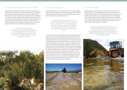
1.3.3 Destruction or degradation of natural habitat1.3.4 Invasive alien species1.3.5 Climate changeHabitat destruction or degradation includes direct impacts (such as bulldozing andplanting of crops in wetlands or river channels) and indirect impacts (such as clearingnatural vegetation in the surrounding catchment, resulting in increased sedimentloads and erosion). Wetland ecosystems have been particularly hard hit: in agriculturalareas they have been predominantly dammed or drained for cultivation, and in urbanareas they are frequently completely transformed by infrastructure development. Thewidespread destruction and modification of river banks is a major problem as thisreduces the filtering capacity that healthy buffers of natural vegetation provide anddestroys freshwater plant and animal habitat (see principle 4 in Section 1.2).Destruction of river banksand wetlands, for example by ploughingor building infrastructure, results inoften irreversible damage to freshwaterecosystems and their ability to provideecosystem services.Invasive alien plant species have a substantial impact on riverine habitat and wateryield, consuming an estimated 7% of South Africa’s total annual runoff. The Workingfor Water programme in South Africa has created considerable awareness of theproblems associated with invasive alien plant water use.Invasive alien plants impact on riverhabitat and water yield. Invasive alien fishsuch as bass and trout, often introducedfor aquaculture or recreational fishing,disrupt ecosystem functioning and arethe number one threat to indigenous fishspecies.Less awareness exists around the threats posed to freshwater ecosystems by invasivealien fish, such as trout, bass and carp. These species are often introduced to riversystems for aquaculture and recreational fishing. Even when invasive alien fish arenot directly introduced in rivers, they often escape from farm dams in which they arestocked (e.g. when the dam wall is breached in floods). Invasive alien fish now occurextensively in most large rivers in South Africa, and impact on indigenous freshwaterplants and animals through altering habitats, competing for resources and eatingindigenous plants and animals. Invasive alien fish present a grave threat to indigenousfish species and have led to local extinctions in some river systems. Invasive alien fishhave also been associated with loss of invertebrates such as dragonflies. Un-invadedstreams (often the smaller tributaries of large rivers) frequently serve as the lastremaining refuges for indigenous freshwater species. Preventing invasions of alienfish in un-invaded streams is crucial, as controlling or eradicating invasive alien fishis difficult and expensive. Weirs can be useful for preventing upstream invasions,although an assessment of the environmental impact of the weir to the entirefreshwater ecosystem should be done prior to construction.Predicted changes in rainfall and temperature will impact on water resources. Thesechanges are likely to have a disproportionately large impact on runoff and river flow(Schulze 2005), with implications for future planning and management of water resources,especially around extreme events such as droughts and floods. For example, keepingrivers and wetlands healthy will help to regulate flow and reduce the risk of flooding.Climate change is also likely to impact on freshwater species. Animals may need to moveto rivers at higher altitude with cooler stream temperatures, and barriers in the riverchannel (such as dams) could restrict such movement.Changes in rainfall and temperature as aresult of climate change are likely to havea large impact on river flows. Keepingfreshwater ecosystems healthy will help themadapt to these changes with least disruptionto ecosystem services.Roxanne KleinAlien vegetation Obstructing river flow Habitat destructionErnst SwartzErnst SwartzIntroduction - 6 -
1.4 Systematic biodiversity planningSystematic biodiversity plans identifygeographic priority areas that need tostay in a natural or near-natural conditionto support sustainable development. Thesystematic approach is embedded in policyand practice in South Africa, and representsthe best available science in this field.Systematic biodiversity planning is a strategic and scientific approach to identifyingthose areas that are the most important for biodiversity conservation. The key objectivesof systematic biodiversity planning are to ensure that all ecosystems and species arerepresented, that key ecological processes are kept intact, and that this is achieved in thesmallest, most efficient area possible (Margules and Sarkar 2007).Systematic biodiversity planning in South Africa is firmly embedded in both policy andpractice. The National <strong>Biodiversity</strong> Framework requires provinces to develop provincialbiodiversity plans. The National Protected Area Expansion Strategy is founded onsystematic biodiversity planning principles, providing the strategy to guide national andprovincial authorities in the expansion of the country’s protected areas over the next 20years. Bioregional plans published in terms of the <strong>Biodiversity</strong> Act must use a systematicbiodiversity planning approach to identify Critical <strong>Biodiversity</strong> Areas and EcologicalSupport Areas, and must integrate priorities for terrestrial and freshwater ecosystems.Examples of such maps can be found on <strong>SANBI</strong>’s <strong>Biodiversity</strong> <strong>GIS</strong> website (http://bgis.sanbi.org). <strong>NFEPA</strong> can be used as the freshwater input into an integrated systematicbiodiversity planning exercise to develop Critical <strong>Biodiversity</strong> Areas and EcologicalSupport Areas for provincial biodiversity plans and bioregional plans in terms of the<strong>Biodiversity</strong> Act. For recommendations on how to accomplish this, the reader is referredto the <strong>NFEPA</strong> technical report available on the <strong>NFEPA</strong> DVD or on <strong>SANBI</strong>’s <strong>Biodiversity</strong> <strong>GIS</strong>website (http://bgis.sanbi.org).Systematic biodiversity plans focus onecosystems, species, ecological processesand connectivity. Freshwater biodiversityplans use sub-catchments as planning units,reflecting the need to manage not just thewater resource itself but also the surroundingland.1.4.1 History of systematic biodiversity planningSystematic biodiversity planning has had almost three decades of research and practicein the terrestrial realm, but has only recently been applied to freshwater settings. Theevolution of systematic biodiversity planning has led to a greater applicability of thescience to freshwater ecosystems, with much of the new ground being pioneered in SouthAfrica (Balmford 2003; Roux et al. 2002; Nel et al. 2009a).Systematic biodiversity planning emerged as a field of science in response to therealisation that ad hoc approaches to conservation, where areas were protected forreasons unrelated to their biodiversity, were not delivering the best bang for theconservation buck (Figure 1.2). The first strategic attempts at identifying priority areaswere focused largely on identifying lists of sites that freshwater scientists knew wereof conservation importance based on their experience in the field. This approach wasfurther advanced by developing scoring systems for comparing the relative importanceof different sites, based on attributes such as habitat diversity, naturalness, representativeness,rarity, species richness and special features (Figure 1.2). Using scoring approachesto prioritise conservation action can be problematic. Choosing high scoring areas overlow scoring ones has a tendency to undermine representation even if representativenessis a criterion that is scored and heavily weighted. Early efforts in systematic biodiversityplanning focused very much on addressing the issue of representation through settingexplicit biodiversity targets for representation, and achieving these targets in an efficientmanner by choosing areas that complement, rather than duplicate, their biodiversityfeatures.The first systematic biodiversity plans focused on representation of terrestrial biodiversityin an efficient set of protected areas (Figure 1.2). By the late 1990s, the scope hadexpanded to include planning for the persistence of biodiversity, recognising that manynatural processes responsible for maintaining biodiversity will not persist if they arenot explicitly incorporated into the identification of spatial priority areas. The focus onprotected areas was also broadened to incorporate planning within multi-functionallandscapes with the outputs of biodiversity plans aimed not only at directing theexpansion of the protected area network, but also at informing land-use planning andday-to-day decisions made about land use throughout the landscape (Cadman et al. 2010).In response to the many calls for science to have more impact on the ground, the trend ofthe 2000s is to plan for implementation of the biodiversity planning outputs, embeddingthe entire exercise in a stakeholder-driven implementation process, and designing mapsand accompanying guidelines that are tailored to meet user needs (Figure 1.2). An evenmore recent advance in systematic biodiversity planning is to use it in planning forecosystem-based adaptation to climate change, by incorporating biophysical featuresthat provide climate change resilience into the identification of spatial priority areas (e.g.altitudinal gradients).Ad hoc approachesScoring approachesPlanning for representationPlanning for persistencePlanning for implementationPlanning for climate change adaptationuntil1970s 1980s 1990s 1990s 2000s 2000sSystematicbiodiversityplanningFigure 1.2: Evolution of systematic biodiversity planning approaches in SouthAfricaPlanning for persistence as well as representation, and planning with a view to informinga range of land uses rather than just the location of protected areas, were importantadvances in the applicability of systematic biodiversity planning to freshwater ecosystems.Given the connectivity of freshwater ecosystems, a focus on representing biodiversity inisolated areas, without regard for upstream, downstream or upland areas, is conceptuallyflawed. It is also seldom feasible to declare whole catchments as protected areas, andtherefore varying levels of protection, ranging from high to low use-restrictions, areneeded. The mid-2000s were characterised by a growing momentum in systematicbiodiversity planning for freshwater ecosystems, with several important advances (Nelet al. 2009a; Linke et al. 2011). All freshwater biodiversity plans use sub-catchments asplanning units, thereby incorporating the need to manage the water resource of concernas well as the surrounding land (Lehner et al. 2006; Thieme et al. 2007). Many include thedevelopment of a river tree-network that can be used to assess upstream-downstreamlinkages (Moilanen et al. 2008). Most plans also consider some form of multiple-usezonation in which different levels of protection are recommended depending on the rolethat sub-catchment fulfils in achieving biodiversity goals (Abell et al. 2007; Thieme et al.2007). For example, the maps of Freshwater Ecosystem Priority Areas in this <strong>Atlas</strong> showcategories that are broadly based on diminishing use restrictions: Freshwater EcosystemPriority Areas (‘FEPAs’) focus on representing natural or near-natural examples offreshwater ecosystems, and management is therefore fairly restrictive; Fish Support Areasneed to be maintained in a condition that supports the fish populations they contain– this need not be a natural or near-natural condition; Upstream Management Areasrequire management only to ensure that human activities do not degrade the conditionof FEPAs and Fish Support Areas that occur downstream.Introduction - 7 -