

NFEPA Atlas 5.3_20111025_FINAL.indd - Biodiversity GIS - SANBI
NFEPA Atlas 5.3_20111025_FINAL.indd - Biodiversity GIS - SANBI
NFEPA Atlas 5.3_20111025_FINAL.indd - Biodiversity GIS - SANBI
- No tags were found...

Create successful ePaper yourself
Turn your PDF publications into a flip-book with our unique Google optimized e-Paper software.
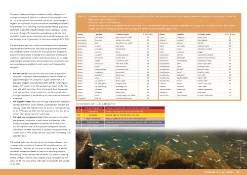
For species and species lineages considered critically endangered orendangered, a target of 100% of all confirmed existing populations wasset. For vulnerable and near threatened species and species lineages, atarget of ten populations was set (or maximum confirmed populations iffewer than ten exist), coinciding wherever possible with sub-quaternarycatchments selected for critically endangered and endangered species,and species lineages. The target of ten populations was derived fromthe IUCN criteria for conservation status which specify that as soon as aspecies drops below ten populations it becomes endangered (IUCN 2001).Fish point locality data from SAIAB and the Albany Museum were usedto guide selection of rivers and associated sub-quaternary catchmentsthat would serve as fish sanctuaries for each species. This database wassupplemented with expert knowledge from experienced fish biologistsin different regions of the country. Historical records that are no longervalid (owing to local extinctions) were excluded from consideration. Fishsanctuary maps were identified for each species, with three possiblecategories:• Fish sanctuaries: These are rivers and associated sub-quaternarycatchments required to meet threatened and near threatened fishpopulation targets. Fish sanctuaries in a good condition (A or Becological category) were selected as FEPAs, and the remaining onesbecame Fish Support Areas. Fish sanctuaries are shown on the FEPAmaps with a fish symbol (see Part 2 of this atlas). A red fish denotesa fish sanctuary that contains at least one critically endangered orendangered population; the remaining fish sanctuaries are shown witha black fish.• Fish migration areas: These cater for large migratory fish that requireconnectivity between certain habitats, usually between mainstem andtributary habitat. Fish migration areas are shown as Fish Support Areason the FEPA maps, but differ from fish sanctuaries in that they do notcontain a fish symbol (see Part 2 of this atlas).• Fish upstream management areas: These are rivers and associatedsub-quaternary catchments in which human activities need to bemanaged to prevent degradation of downstream fish sanctuariesand fish migration areas. All fish upstream management areas areidentified on the FEPA maps either as Upstream Management Areas, orin some cases as FEPAs if they were also required for representing riverecosystem types.Table 3.2: Freshwater fish species for which fish sanctuaries were explicitly identified. Species marked with an asterisk require taxonomic updating as recent research shows thatthey contain several distinct linrefined by regional fish biologists tocritically endangered (CR), endangered (EN) and vulnerable (VU) – were included. Species classified as data deficient (DD) by IUCN, but which contain several distinctlineages that are considered threatened were also included, as well as near threatened species (NT).Genus Species Common name IUCN Status Genus Species Common name IUCN StatusAmphilius natalensis* Natal mountain catfish DDClarias theodorae Snake catfish LCAustroglanis barnardi Spotted rock catfish ENGalaxias zebratus* Cape Galaxias DDAustroglanis gilli Clanwilliam rock catfish VUHydrocynus vittatus Tigerfish LCAustroglanis sclateri Rock catfish LCKneria auriculata Southern kneria CRBarbus amatolicus Amatole barb VULabeo seeberi Clanwilliam sandfish ENBarbus andrewi Witvis ENLabeo umbratus Moggel LCBarbus anoplus* Chubbyhead barb DDLabeobarbus capensis Clanwillliam yellowfish VUBarbus brevipinnis Shortfin barb NTOpsaridium peringueyi Southern barred minnow LCBarbus calidus Clanwilliam redfin VUOreochromis mossambicus Mozambique tilapia NTBarbus erubescens Twee River redfin CRPseudobarbus afer* Eastern Cape redfin NTBarbus hospes Namakwa barb LCPseudobarbus asper Smallscale redfin ENBarbus lineomaculatus Line-spotted barb VUPseudobarbus burchelli* Burchell’s redfin CRBarbus motebensis Marico barb VUPseudobarbus burgi* Berg River redfin ENBarbus pallidus* Goldie barb DDPseudobarbus phlegeton* Fiery redfin CRBarbus serra Sawfin ENPseudobarbus quathlambae* Maloti redfin ENBarbus sp. “Banhine” Banhine barb CRPseudobarbus tenuis* Slender redfin NTBarbus sp. “Ohrigstad” Ohrigstad barb DDSandelia bainsii Eastern Cape rocky ENBarbus sp. “Waterberg” Waterberg barb NTSandelia capensis* Cape kurper DDBarbus treurensis Treur River barb ENSerranochromis meridianus Lowveld largemouth ENBarbus trevelyani Border barb ENSilhouetta sibaya Sibayi goby ENChetia brevis Orange-fringed river bream ENVaricorhinus nelspruitensis Incomati chiselmouth NTChiloglanis bifurcus Incomati suckermouth ENDescription of IUCN categoriesCR Critically Endangered Facing an extremely high risk of extinction in the wildEN Endangered Facing a very high risk of extinction in the wildVU Vulnerable Facing a high risk of extinction in the wildNT Near Threatened Likely to qualify as CR, EN or VU in the near futureDD Data Deficient Inadequate information to make an assessment of its risk of extinctionLC Least Concern Not threatenedFish sanctuaries for every threatened and near threatened species werecombined and the number of threatened fish populations within eachsub-quaternary catchment was calculated to derive Figure 3.4. A list ofthreatened and near threatened fish that occur within any particularfish sanctuary can be obtained from the <strong>NFEPA</strong> DVD, either by queryingthe fish sanctuary shapefile, or by using the unique sub-quaternary codeshown on the FEPA maps (Part 2 of the atlas) to consult the look-up tableon the DVD.Thomas Peschak/WWF-SANational map products - 43 -


