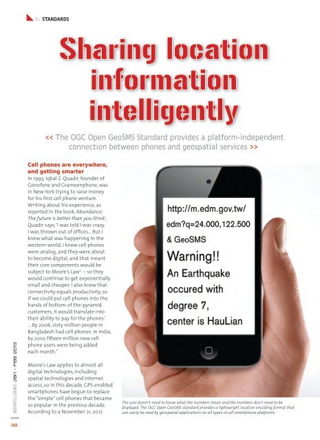
STANDARDSSharing locationinformationintelligently>GEOINTELLIGENCE jan - feb 2013Cell phones are everywhere,and getting smarterIn 1993, Iqbal Z. Quadir, founder ofGonofone and Grameenphone, wasin New York trying to raise moneyfor his first cell phone venture.Writing about his experience, asreported in the book, Abundance:The future is better than you think 1 ,Quadir says, ‘I was told I was crazy.I was thrown out of offices... But Iknew what was happening in thewestern world. I knew cell phoneswere analog, and they were aboutto become digital, and that meanttheir core components would besubject to Moore’s Law 2 – so theywould continue to get exponentiallysmall and cheaper. I also knew thatconnectivity equals productivity, soif we could put cell phones into thehands of bottom-of the-pyramidcustomers, it would translate intotheir ability to pay for the phones.’… By 2006, sixty million people inBangladesh had cell phones. In India,by 2010, fifteen million new cellphone users were being addedeach month.”Moore’s Law applies to almost alldigital technologies, includingspatial technologies and Inter<strong>net</strong>access, so in this decade, GPS-enabledsmartphones have begun to replacethe “simple” cell phones that becameso popular in the previous decade.According to a November 21, 2012The user doesn’t need to know what the numbers mean and the numbers don’t need to bedisplayed. The OGC Open GeoSMS standard provides a lightweight location encoding format thatcan easily be read by geospatial applications on all types on all smartphone platforms38
press release from Ericsson Mobility,approximately 40 per cent ofall phones sold in Q3 2012 weresmartphones and the growth ofsmartphone data traffic is expectedto exceed the overall average. Totalmobile subscriptions are expected toreach 6.6 billion by the end of 2012and 9.3 billion by the end of 2018.But what does the rapid spreadof cell phones and smartphonesmean for geospatial intelligence?What are the opportunities andwhat are the threats? If cell phones‘know’ their location, how canthey communicate that locationinformation? How can the locationof a cell phone, or the locationsof millions of cell phones, beintegrated into a larger picture ofthe world? How can users get theother spatial information they needto make decisions based on theirlocation?Even phones that do not have GPSor Inter<strong>net</strong> access can report theirapproximate location. Cell phonecompanies (carriers or operators)can determine the approximateposition of a phone – within akilometer or so – by ‘multilateration’of radio signals between differentcell phone towers. 3 The carriercan thus report a cell phone’sapproximate location to a crisiscenter, for example. Also, usingtext messages or recorded voicemessages, a carrier can sendlocation-related messages to oneor more cell phones in a particulargeographic area.GPS-enabled smartphones reportlocation much more precisely, andthey can report location directly tothe smartphone user as well as thecarrier.The carriers and cell phonemanufacturers determine whatusers can do with their GPS. Oftencarriers limit user access to freemapping and navigation services sothe carrier can charge for mappingand route finding. The general trend,however, is towards open access tothe inter<strong>net</strong>. Smart phones suchas the iPhone and phones that useGoogle’s Android operating systemmake it easy for app developersto access the latitude/ longitudecoordinates provided by the GPS;and thus, through hundreds ofavailable apps, users can accesslocation-based services ofmany kinds.Communicating locationinformation between differentcompanies’ smartphones, however,has not been easy because untilrecently there was no standard wayto do this. Communicating simplelatitude-longitude coordinatesisn’t complicated, but computersexpect consistency. To ensureinteroperability, a standard isrequired to establish rules suchas coordinate order (latitude thenlongitude), whether these numbersare to be expressed as floating pointnumbers or degrees, minutes andseconds, whether coordinates areseparated by a comma or a space,and so forth.As explained below, it turns out thatthe venerable SMS standard for textmessaging provides a fast, nearlyuniversal, low-bandwidth, vendorneutralmedium for conveyinglocation information. The OGCOpen GeoSMS Standard provides astandard encoding designed to usethis channel. This same lightweightencoding can be used to conveylocation information attachedto photos taken by smartphonecameras. It can also be used toconvey location information inmachine-to-machine messages, asin vehicle tracking applications orsensor alerts that operate throughwireless <strong>net</strong>works.OGC Open GeoSMS Standard:Using text messages tocommunicate locationAware of the industry trendsdescribed at the beginning ofthis article, in Chinese Taipei thegovernment-sponsored IndustrialTechnology Research Institute’s (ITRI)Information and CommunicationsResearch Laboratories developeda way for SMS-enabled handhelddevices to exchange coordinateswithout manual entry. Thisspecification soon came intowide use by a number of <strong>net</strong>workoperators and system integratorsin the region, and ITRI brought thespecification into the OGC to bemade into the OGC Open GeoSMSinternational standard.ITRI’s specification was developedwith an important disastermanagement application in mind.In Chinese Taipei, dangerous debrisflows of rock and soil are commonbecause of steep slopes, unstablesoils, earthquakes and monsoons.ITRI’s spatially enabled SMS playsa role in a sophisticated systemthat was developed for monitoringdebris flow conditions andwarning towns when a debris flowis imminent or in progress. Themonitoring is accomplished usinga wide array of sensors that areprogrammed to send messages toofficials and citizens via multiplechannels, including Open GeoSMS.Not-for-profit disaster relieforganisations such as Ushahidi,InRelief, Sahana and Haiti SDIVGI are implementing OpenGeoSMS. The Sahana platformfor disaster management wascreated in response to the 2004Sri Lanka tsunami. The Ushahidicrowdsourcing crisis informationcollection and map visualisationapplication was developed in 2007-2008 to help with the Kenyan crisis.Sinsai.info (http://www.sinsai.info)(Sinsai means earthquake disasterin Japanese) is a crisis-mapping sitethat used the Ushahidi platformfor response to the Great EastJapan Earthquake. It was launchedfour hours after the earthquakeoccurred.The Open GeoSMS candidatestandard was adopted as anofficial standard by the OGC’sinternational membership lastGEOINTELLIGENCE jan - feb 201339