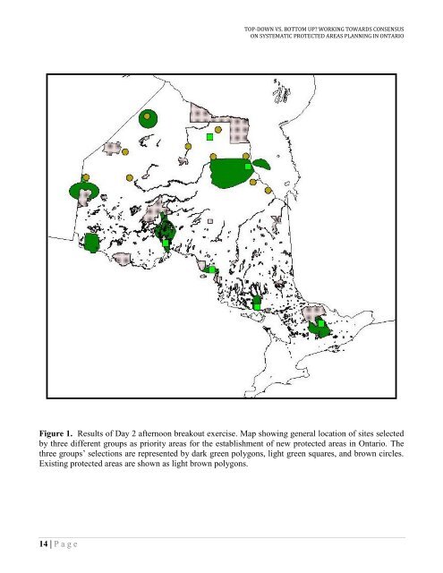
TOP-DOWN VS. BOTTOM UP? WORKING TOWARDS CONSENSUSON SYSTEMATIC PROTECTED AREAS PLANNING IN ONTARIOFigure 1. Results of Day 2 afternoon breakout exercise. Map showing general location of sites selectedby three different groups as priority areas for the establishment of new protected areas in Ontario. Thethree groups‟ selections are represented by dark green polygons, light green squares, and brown circles.Existing protected areas are shown as light brown polygons.14 | P a g e
SUMMARY OF THE PARKS RESEARCH FORUM OF ONTARIO (PRFO)STATE OF THE ART PROTECTED AREAS DESIGN WORKSHOP, 2006ConclusionsThe workshop illustrated that many agencies and researchers are applying scientific approaches to thedesign of protected areas. The workshop provided a forum for researchers to hear about each others‟methods, data sources and results. While we set a goal to identify congruencies and complementaritiesamong the various methods for engaging in systematic protected areas design, different groups inOntario varied quite dramatically in their approaches, data sets, and tools used. A number of the casestudies used in-house software for all or part of the analysis. While certain projects and datasets mightrequire customized software and GIS models to complete the analysis, without widespread sharing ofthese tools (via share-ware or open-source publishing), there is a high risk of individual groups“reinventing the wheel” and wasting valuable research time, energy, and funds to develop tools that mayalready exist. As well, inconsistencies in tools and methods make it difficult for planning projects to bereproduced by other research groups (reproducibility being the gold standard for scientific defensibilityin an experimental context) to verify results. Additionally, the variety of tools and data sets applied tothe various planning exercises may lead sceptics to conclude that systematic protected areas planningusing explicit design principles can be almost anything, leading to lack of confidence andunderinvestment. We encourage researchers to share their tools and techniques more widely, and hopethat this workshop facilitated an increased level of communication amongst protected areas researchersinvolved in systematic conservation planning.An additional goal of the workshop was to identify priority areas for implementation of protected areas,based on consensus among organizations, agencies and research methods. The priority areas forprotection as identified in the workshop case studies showed relatively little overlap. This is due, in largepart, to differences in the way research activities and target regions in Ontario were divided up amongstthe case studies (e.g., NCC focused its analysis on the Great Lakes basin, while WWFC focused strictlywithin northeastern Ontario). Only Crins and Davis‟ and Wiersma and Nudds‟ cases encompassed all ofOntario. However, there was also little overlap in the products between these latter two projects, whichmight have been due to the different biodiversity surrogates used (landform-vegetation associations <strong>vs</strong>.disturbance-sensitive mammals) or the methodologies used (GapTool <strong>vs</strong>. persistence-based targets andgreedy-heuristic algorithms), or the scale of analysis. Such discrepancies are problematic whenpresenting protected areas plans to politicians and decision makers who may view us as a homogeneousgroup of “protected areas researchers”.It is difficult to evaluate how well the workshop was able to achieve the goal of working towardconsensus on best practices. The structure of the breakout groups was intended to facilitate generalconsensus, but consensus within and between breakout groups was never formally assessed.Congruencies in priority areas that emerged out of the mock-planning exercise (Figure 1) wereencouraging. However, the rationales for site selection remained dominated by emphasis onrepresentation, and less of persistence. That is, sites were often selected because of presence ofrare/unique species or landform features, and with little consideration of all of the “Pressey Steps”necessary to encourage persistence of what is represented. Given that workshop participants contributedto the elaboration of the “Pressey Steps”, we hope that the resulting design principles captured by thisworkshop find wider application in the real world of protected areas planning and implementation.Overall, the workshop objective to conduct “research on research” was met. Feedback from participantsafter the workshop was very positive, with many commenting that it was one of the most useful and15 | P a g e