TOP-DOWN VS. BOTTOM UP? WORKING TOWARDS CONSENSUSON SYSTEMATIC PROTECTED AREAS PLANNING IN ONTARIOName of Presenter(s): Kara Brodribb & Dan Kraus1. Title of presentation: Great Lakes Conservation Blueprint for Biodiversity2. Name of representative protected area design project: Great Lakes Conservation Blueprint forTerrestrial and Freshwater Biodiversity3. Date of project inception: 20014. Number of staff involved in the project: Approximately 5, + approximately 20 GIS staff, + team ofcore science advisors5. Please describe the conservation applications for your project:NCC has been using the results of the Conservation Blueprint to more effectively focus the direction ofconservation resources. NCC has used the information to better understand and communicate theconservation priorities and needs for different areas in the Great Lakes basin. Within areas that havebeen identified as high priority in the Conservation Blueprint, NCC works with partners to develop longtermstrategic plans to better protect the most significant biodiversity values. Information from theBlueprint is used to support a broad array of land protection strategies, including prioritizing landparcels for acquisition and stewardship support, informing land use policy, and education.NCC is also working with Great Lakes partners in the U.S. to develop a binational understanding ofbiodiversity values and conservation. Combining this information will be important for betterunderstating the status, threats and conservation needs of the entire Great Lakes system. NCC andpartners are using this information to support a number of other conservation planning projects includingthe Great Lakes Islands Biodiversity study, and a LaMP-based Conservation Strategy for Lake Ontario.The Ontario Ministry of Natural Resources is using the results of the project in a number of waysincluding biodiversity reporting, land use planning, protected areas monitoring, and recovery planningfor species and habitats at risk.6. Brief overview of project:Goal/purpose of project: The goal of the Conservation Blueprint project is to identify a network of siteson the landscape that, if properly conserved, has the ability to sustain all elements of terrestrial andfreshwater biodiversity in the Great Lakes basin. The project methods include coarse- and fine-filterbiodiversity analysis and gap analysis.Study region for project: Ontario portion Great Lakes Ecoregion (terrestrial: all of Ecoregions 7E, 6E,5E, Ecodistricts 4E1, 4E3, 3E4, 3W3, 3W6, 4E2; aquatic: Great Lakes basin)Partners: The project was coordinated by NCC, OMNR and the Natural Heritage Information Centre.There were also partnerships with scientists from a number of other agencies including Ontario Parks,Environment Canada, Ducks Unlimited Canada, Trout Unlimited Canada, Ontario Power Generation,Fisheries and Oceans Canada, Royal Ontario Museum, University of Toronto, University of Guelph, etc.34 | P a g e
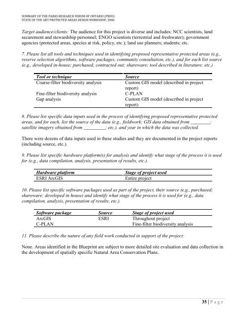
SUMMARY OF THE PARKS RESEARCH FORUM OF ONTARIO (PRFO)STATE OF THE ART PROTECTED AREAS DESIGN WORKSHOP, 2006Target audience/clients: The audience for this project is diverse and includes: NCC scientists, landsecurement and stewardship personnel; ENGO scientists (terrestrial and freshwater); governmentagencies (protected areas, species at risk, policy, etc.); land use planners; students; etc.7. Please list all tools and techniques used in identifying proposed representative protected areas (e.g.,reserve selection algorithms, software packages, community consultation, etc.), and for each list source(e.g., developed in-house; purchased; contracted out; shareware; tool described in literature; etc.)Tool or techniqueCoarse-filter biodiversity analysisFine-filter biodiversity analysisGap analysisSourceCustom GIS model (described in projectreport)C-PLANCustom GIS model (described in projectreport)8. Please list specific data inputs used in the process of identifying proposed representative protectedareas, and for each, list the source of the data (e.g., fieldwork; GIS data obtained from ________;satellite imagery obtained from _________; etc.), and year in which the data was collected.There were dozens of data inputs used in these studies and they are documented in the project reports(including source, etc.).9. Please list specific hardware platform(s) for analysis and identify what stage of the process it is usedfor (e.g., data compilation, analysis, presentation of results, etc.).Hardware platformESRI ArcGISStage of project usedEntire project10. Please list specific software packages used as part of the project, their source (e.g., purchased;shareware; developed in house) and identify what stage of the process it is used for (e.g., datacompilation, analysis, presentation of results, etc.).Software package Source Stage of project usedArcGIS ESRI Throughout projectC-PLANFine-filter biodiversity analysis11. Please describe the nature of any field work conducted in support of the project:None. Areas identified in the Blueprint are subject to more detailed site evaluation and data collection inthe development of spatially specific Natural Area Conservation Plans.35 | P a g e


