

Top-Down vs. Bottom Up: Working Towards Consensus ... - CASIOPA
Top-Down vs. Bottom Up: Working Towards Consensus ... - CASIOPA
Top-Down vs. Bottom Up: Working Towards Consensus ... - CASIOPA
- No tags were found...

You also want an ePaper? Increase the reach of your titles
YUMPU automatically turns print PDFs into web optimized ePapers that Google loves.
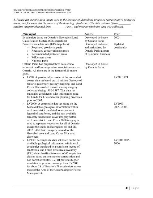
SUMMARY OF THE PARKS RESEARCH FORUM OF ONTARIO (PRFO)STATE OF THE ART PROTECTED AREAS DESIGN WORKSHOP, 20068. Please list specific data inputs used in the process of identifying proposed representative protectedareas, and for each, list the source of the data (e.g., fieldwork; GIS data obtained from ________;satellite imagery obtained from _________; etc.), and year in which the data was collected.Data input Source YearEcodistricts based on Ontario‟s Ecological Land Developed in-house 2003Classification System (GIS shapefiles)by Ontario ParksProtected area data sets (GIS shapefiles):Developed in-house‣ Regulated provincial parksand maintained by‣ Regulated conservation reservesOntario Parks as part‣ Recommended protected areasof its normal business‣ Wilderness areas‣ National parksOntario Parks has prepared three data sets torepresent landform/vegetation associations acrossOntario. All three are in the format of 25-metregrids.‣ LV28: A provincially consistent but somewhatcoarse data set based on 1:1 million Geology ofOntario quaternary geology mapping, and LandCover 28 classified remote sensing imagerycollected during 1986-1997. This data setmaintains consistency with information usedfor Lands for Life and other planning processesprior to 2005.‣ LV2000: A composite data set based on thebest available geological information withineach ecodistrict translated to a consistentlegend of landforms, and the best availableremotely sensed land cover imagery withineach ecodistrict. Land Cover 2000 imagery isused to represent vegetation for all of Ontarioexcept the south. In Ecoregions 6E and 7E,2002 LANDSAT imagery is used for theGreenbelt area and Land Cover 28 is usedelsewhere.‣ LVFRI: A composite data set based on the bestavailable geological information within eachecodistrict translated to a consistent legend oflandforms, and Forest Resources Inventory(FRI) data classified into a set of 45 vegetationclasses based on tree species composition andnon-forest attributes. LVFRI provides higherresolution vegetation coverage than LV2000for about 28 of Ontario‟s 71 ecodistricts acrossmost of the Area of the Undertaking for ForestManagement.Developed in-houseby Ontario Parks<strong>Up</strong>datedcontinuallyLV28: 1999LV2000:2005- 2006LVFRI: 2005-200641 | P a g e