GEOLOGY OF THE GREYMOUTH AREA - GNS Science
GEOLOGY OF THE GREYMOUTH AREA - GNS Science
GEOLOGY OF THE GREYMOUTH AREA - GNS Science
- No tags were found...

Create successful ePaper yourself
Turn your PDF publications into a flip-book with our unique Google optimized e-Paper software.
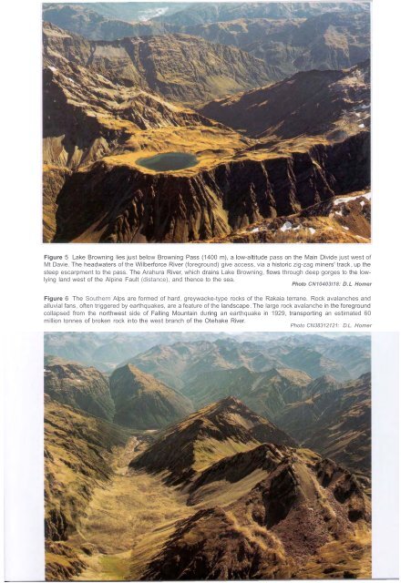
Figure 5 Lake Browning lies just below Browning Pass (1400 m), a low-altitude pass on the Main Divide just west ofMt Davie. The headwaters of the Wilberforce River (foreground) give access, via a historic zig-zag miners' track, up thesteep escarpment to the pass. The Arahura River, which drains Lake Browning, flows through deep gorges to the lowlyingland west of the Alpine Fault (distance), and thence to the sea.Photo CN10403l18: D.L HomerFigure 6 The Southern Alps are formed of hard, greywacke-type rocks of the Rakaia terrane. Rock avalanches andalluvial fans, often triggered by earthquakes, are a feature of the landscape. The large rock avalanche in the foregroundcollapsed from the northwest side of Falling Mountain during an earthquake in 1929, transporting an estimated 60million tonnes of broken rock into the west branch of the Otehake River.Photo CN38312121: D.L. Homer