ABSTRACTThe Greymouth 1:250 000 geological map covers13 000 km 2 , and includes the central part ofthe West Coastregion in the South Island ofNew Zealand. The map area isbisected by the Alpine Fault- a major strikC}-slip fault fonningthe active plate boundary between the Pacific and Australiantectonic plates. Late Cenozoic movement (which continuesto the present day) has led to the juxtaposition of twodifferent geological provinces.Southeast of the Alpine Fault the rocks are part of theMesozoic Torlesse composite terrane, a thick, highlydeformed sequence of mainly submarine fan sedimentaryrocks, of quartzofeldspathic, continental derivation. Thetopography is mountainous, and the Southern Alps rise fromnear sea level to a maximum height ofover 2200 metres.Northwest ofthe Alpine Fault the pre-Cretaceous rocks arePaleozoic metasedinientary and plutonic rocks that representa fragment of the Gondwanaland supercontinent.Gondwanaland started to break up in the Early Cretaceous,a period of widespread· emplacement of granitoid rocks,uplift, and detachment faults -resulting in the formation ofmetamorphic core complexes. Fanglomerates were depositedaround the rising mountain ranges.The olderrocks on both sides ofthe Alpine Fault were largelycovered by Cenozoic sediments. Regional extension led tosubmergence by the middle ofthe Oligocene,·and widespreaddeposition of limestone or calcareous sedimentary rocks.Development of the present oblique-compressional plateboundary started in the Early Miocene, and led to a complexlate Cenozoic history, with development of small faultboundedbasins and widespread uplift and erosion. Rapiduplift of the Southern Alps started in the Pliocene, but theWest Coast ranges did not start to rise and form the presentrange-and-basin topography until the early Quaternary.Regional uplift by folding and faulting continues to thepresent day.Glaciation during cool periods in the Quaternary resultedin downstream aggradation from moraines and down-valleyglacial outwash gravels. During warmer, interglacial periodsthere is evidence of higher sea levels near the coast frommarine terraces that have been subsequently uplifted.Gold has been mined for over 100 years from both quartzveins and alluvial deposits. Over70 000 kg ofgold has beenextracted from quartz veins in the Reefton Goldfield, andplanning is currently underway to open a new opencastmine.Substantial reserves ofilmenite have been defined by drillingin postglacial sands near the coast. The map area containsalmost all the reserves ofbituminous coal in New Zealand(300 million tonnes estimated as recoverable), mainly inthe Buller and Greymouth coalfields, although not all ofthis may be able to be mined. Recorded seeps and shows ofoil and gas have encouraged prospecting for hydrocarbons,but no commercial finds have yet been located.The Greymouth map area is subject to natural hazards,including a high level of seismic hazard from the AlpineFault and other active faults, with potential for earthquakeshaking, landsliding, liquefaction and ground rupture.Several large, damaging earthquakes with epicentres withinthe map area have occurred within the last 100 years.Landsliding, rockfall, tsunami and flooding are ongoinghazards.KeywordsGreymouth; West Coast region; 1:250 000 geological map; geographic information system; QMAP; digital data;bathymetry; Buller terrane; Takaka terrane; Torlesse composite terrane; Rakaia terrane; Pahau terrane; EskHead belt; metamorphism; textural zones; Karamea suite; Rahu suite; Separation Point suite; Alpine Fault;Southern Alps; Grey Valley; Paparoa Range; Victoria Range; Greenland Group; Gondwanaland; Waipounamuerosion surface; glaciation; interglacial; dredge tailings; gold; ilmenite; uranium; clay; greenstone; pounamu; .nephrite; limestone; coal; hydrocarbons; Kotuku oil seep; active fault; engineering geology; earthquake; ModifiedMercalli scale; landslide; tsunami, 133, J31, J32, J33, K29, K30, K31, K32, K33, L29, L30, L31, L32, L33.v
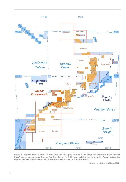
170" E: 175" E'%~O ::>_~ : ~- -- -- __c$>~ _ ------- -.-.-----.·-··r -.- -- -.- ----.. '-K"t,,;,,"00...... . 200~ -~ v :~ iis'-0'--.-- --..-,-. -..--.----- -. --.-- ---.-- --. ----.. ~!i:_~Whangar ~ i';SI-_ -,--!,i-.L---, '51,,I,.----i /~~7 mm/ rWak:ati6l!J ".I,MurihikuI, IAuckland, I: f-----r+- I -L._,--_----,; \ / /.... ~ :', Waikato . R ~O;~~~~ II ~ 11 !Chal/enger :, ';.j i 47 ~m/y~TaranakiB'aY";4,I. Raukumara ::, Tar,!~akl " - ) '.f< ; , iPlateau ; Basin ~ .' jL/ j ;I, ,' " HawKes I.~ 9:-?- -..------ ---~~~~-;~ ~;~~ .T'------..--..---- ------ -.-. --. --..-; ; j/ ~/' -.- -.-.:~~~~lf..4Q : i~·, ';S Plate Nelson well lnQt69! wa"a.~rapa ~ i1 '5 ,/;;.. / 'l>\:- !,/ ~ .-'" Ii ~ d~ :" QMAP : ' jfIf/f"V / I V .},\, :, ---.- ~ . 1-1" l!7.'9 -/,/ ..,,? " ' ,Greymouth I.... Jt./"Co' f ~ I\ ,,/:Z~oUra ...... .....r 41 mm/yr p, f/ ~Y.. ~ acific, /.0'-' - [if'£-! PlateI1 '~'~~;i -1;"?"'-~\'/" 38 in'1fl1 r~/ . \ ChristchurchHaas V~ Aor.aki "./ I ~ r"'-/, DunedinCampbel/ PlateauChatham Rise !I,,, ,I Waitakr - -- ------._--------- -. - - -"t - -.--. - _. -------- - -- - .-. . .. __ .~~? ~_ ~_20000i-...."".;.;'OO ~_....;;; 200Kilometres,,Bounty !Trough !,170" E ,175" E180" E'Figure 1 Regional tectonic setting of New Zealand showing the location of the Greymouth geological map and otherQMAP sheets, major offshore features (as illustrated by the 2000 metre isobath), and active faults. Arrows indicate thedirection and rate of convergence of the Pacific Plate relative to the Australian Plate.Adapted from Anderson & Webb (1994)vi
- Page 3 and 4: GEOLOGY OF THEGREVMOUT;H AREAScale
- Page 5: CONTENTSABSTRACT . v LATE CRETACEOU
- Page 9 and 10: ..""..""..""1 Angus 19842 Becker &
- Page 11 and 12: Cretaceous & Cenozoic sedimentary r
- Page 13 and 14: Figure 5 Lake Browning lies just be
- Page 15 and 16: Figure 9 About 350 000 to 250 000 y
- Page 17 and 18: Northwest of the Alpine Fault, the
- Page 19 and 20: Figure 14 Gneissic rocks of the Bul
- Page 21 and 22: Figure 15 Quarry in SluiceBox Limes
- Page 23 and 24: 16Figure 17 A selection of U-Pb dat
- Page 25 and 26: Figure 18 Typical lithologies of th
- Page 27 and 28: Figure 20 Typical sedimentary litho
- Page 29 and 30: association. The boundary between t
- Page 31 and 32: Figure 22 Gently dipping Paparoa Co
- Page 33 and 34: Figure 24 Aerial view of an opencas
- Page 35 and 36: Figure 27 Panoramic view looking ea
- Page 37 and 38: Late Miocene to Pliocene sedimentar
- Page 39 and 40: Interglacial Glacial Ag. a-isotopeS
- Page 41 and 42: Alluvial depositsAlluvial and f1u v
- Page 43 and 44: Postglacial lake deposits of peat a
- Page 45 and 46: J:,..,.~~ "'~}ii;~ ': ~, ' tf[' ~-;
- Page 47 and 48: Figure 43 Deep opencast pit (centre
- Page 49 and 50: Figure 44 A large lens of earliest
- Page 51 and 52: UndergroundOpencastMeasured Indicat
- Page 53 and 54: GEOLOGICAL HAZARDSSeismotectonic (e
- Page 55 and 56: Figure 49 The hillside beneath Mt R
- Page 57 and 58:
Figure 51 Active landslides and scr
- Page 59 and 60:
REFERENCESAdams, CJ.; Harper, C.T.;
- Page 61 and 62:
54Gair, H.S. 1962: Notes on the geo
- Page 63 and 64:
Nathan, S. 1978b: Sheets S31 & part
- Page 65 and 66:
Waight, T.E.; Weaver, S.D.; Muir, R