LATE CRETACEOUS AND TERfiARYLate Cretaceous to earliest Pleistocene sedimentary rocksrecord the format ion and subsequent deformation oflocalised, faul t-bounded basins in response to changingtectonic stresses across the developing boundary betweenthe Australian and Pacific plates. Most time intervals fromLate Cretaceou s to Earl y Pleistocene are represented,although no single basin has a complete sequence. Thesedimentary succession locally shows marked lateral faciesand thickness changes as well as abrupt changes indepocentres and changing paleo-highs. Virtually the wholearea was submerged be neath the sea by the latestOligocene, with a regression and the emergence of lowhills th rough the Miocene and Pliocene. The present daymountain ranges are a latest Cenozoic feature.T he Southern Alps, immediately southeast of the AlpineFault, did not stal1 to rise rapidly until late Cenozoic time.Although onl y two small areas of Cenozoic sedimentaryrocks are preserved southeast of the Alpine Fault in thi smap area, it is inferred that much of Canterbury wassubmerged during the Cenozoic (Field & Browne 1989),with maxi mum submergence during the Oligocene.Late Cretaceous to Paleocene sedimentary rocksLate Cretaceous to Paleocene rocks are restri cted to anarrow, NNE-trending basin (Paparoa Trough) in thecentral part of the map area (Nathan and others 1986).Paparoa Coal Measures (Kpc) consist of a non-marineassemblage of flu vial conglomerate, sandstone, lacustrinemudstone, and lensoid coal seams (Figs 22 & 23). Drillingfor coal and petro leum exploration has defined thethickness variatio n with in the formation, indicating amaximum thickness of abollt 750 metres in the axis of thetrough. Detailed mapping within the Greymouth Coalfield(Gage 1952) showed that the Paparoa Coal Measures canbe subdivided into seven units, now mapped as members(Nathan 1978a). The key to subdi vision is the recognitionof three lacustri ne mudstone marker bands separatingthicker un its of coal measures (predominantly quartzofeldspathicsandstone. with conglomerate and coal seams).The uppermost (Dunollie) member is di stinctl y morequartzose towards the top, indicating increased chemicaldecomposition of less stable mineraJs as the tempo of upliftand erosion slowed in the Early Paleocene.Basalt flows and breccia are interbedded withi.n the lowerpart of the Paparoa Coal Measures at several locaJities,and have been dated at 68-7 1Ma (Sewe ll and others 1988;Nathan and others 2000). They appear to be part of anepisode of latest Cretaceous basaltic volcanism that waswidespread on the West Coast (Nathan and others 1986).Pollen dating, summarised by Raine (1984), shows thatmost of the Paparoa Coal Measures is latest Cretaceous inage, but the uppermost part is Early Paleocene. TheCretaceous-Tertiary boundary occurs within a coal seamin the upper part of the Rewanui Member (Raine 1994;Vajda and others 2001).Eocene sedimenta ry rocksTectonic acti vity recommenced in the late Middle Eocene(about 38 million years ago), with regional extensionleading to the fo rmation of local basins, many faul tbounded, separated by areas of low-lying land. At the sametime a gradual marine transgressio n started , andprogressively inundated the whole West Coast region overthe succeeding 15 mi llion years. By the end of the Eocenethe map area had become an archipelago of low-lyingislands sunounded by shallow seas (Nathan and others1986).The oldest Eocene sedimentary rocks are Brunner CoalMeasures (Eb), c onsis ting o f quartz sandstone,conglomerate, carbonaceous shale, and lensoid coal seamslocally up to 10m thick (Flores & Sykes 1996; Titheridge1993). The formation is characteristically quartzose, beinglargely derived from deeply weathered, granitoid basementrocks. Having been deepl y buried in some areas, thesandstone beds are commonly silica-cemented, and thusform characteri stic bluffs and plateaus (Figs 10, 24).The coal measures are conformably (and in most placesg radationally) overlain by shallow-water sedimentaryrocks. The most widespread unit is massive, dark browncarbonaceous mudstone of the Ka iata Formation (Erk;Fig. 26) which locall y contains interbedded mass-flo wdeposits near Greymouth and Westport (Nathan and others1986). In some areas, the coal measures are overlain byshallow marine sandstone which has been given a varietyof local names (e.g., [sland Sandstone near Greymouth),but which are here generali sed as a single un it (Ers).Late Paleocene - Early Eocene unconformityEarly in the Paleocene there was a general slowing in tectonic activity. Sedimentation ceased over the whole of themap area, and there is no Late Paleocene - Early Eocene stratigraphic record. This break represents a period ofwidespread peneplanation and a regional unconformity that affected much of the New Zealand region (Suggate andothers 1978), more recently named Ihe Waipounamu erosion surface (LeMasurier & Landis 1996).Generally the rocks immediately beneath the unconformity are deeply leached, wilh the less resistant minerals suchas feldspar and biotite decomposed, leaving a residuum consisting mainlyofquartz and kaolin clay (Fig. 25). Wellman(1951) described the nature of the contact between the Paparoa Coal Measures and overlying Eocene sedimentsnear Greymouth, providing evidence for a break in sedimentation accompanied by subaerial weathering (Fig. 23).The Waipounamu erosion surface forms a marked topographic feature in several parts of the Greymouth map area(e.g. Fig. 10). In all cases the surface has been covered by Late Eocene-Oligocene sediments, and subsequentlyuplifted and exhumed in the late Cenozoic.'-----------------------------J 25
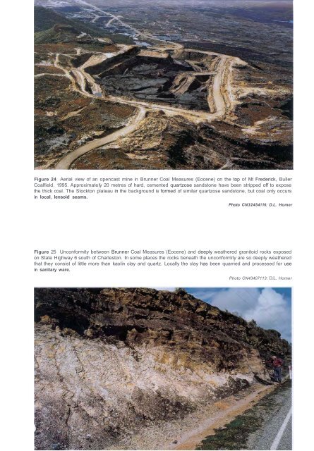
Figure 24 Aerial view of an opencast mine in Brunner Coal Measures (Eocene) on the top of Mt Frederick, BullerCoalfield, 1995. Approximately 20 metres of hard, cemented quartzose sandstone have been stripped off to exposethe thick coal. The Stockton plateau in the background is formed of similar quartzose sandstone, but coal only occursin local, lensoid seams.Photo CN32454116: D.L. HomerFigure 25 Unconformity between Brunner Coal Measures (Eocene) and deeply weathered granitoid rocks exposedon State Highway 6 south of Charleston. In some places the rocks beneath the unconformity are so deeply weatheredthat they consist of little more than kaolin clay and quartz. Locally the clay has been quarried and processed for usein sanitary ware.Photo CN43407113: D.L. Homer
- Page 3 and 4: GEOLOGY OF THEGREVMOUT;H AREAScale
- Page 5 and 6: CONTENTSABSTRACT . v LATE CRETACEOU
- Page 7 and 8: 170" E: 175" E'%~O ::>_~ : ~- -- --
- Page 9 and 10: ..""..""..""1 Angus 19842 Becker &
- Page 11 and 12: Cretaceous & Cenozoic sedimentary r
- Page 13 and 14: Figure 5 Lake Browning lies just be
- Page 15 and 16: Figure 9 About 350 000 to 250 000 y
- Page 17 and 18: Northwest of the Alpine Fault, the
- Page 19 and 20: Figure 14 Gneissic rocks of the Bul
- Page 21 and 22: Figure 15 Quarry in SluiceBox Limes
- Page 23 and 24: 16Figure 17 A selection of U-Pb dat
- Page 25 and 26: Figure 18 Typical lithologies of th
- Page 27 and 28: Figure 20 Typical sedimentary litho
- Page 29 and 30: association. The boundary between t
- Page 31: Figure 22 Gently dipping Paparoa Co
- Page 35 and 36: Figure 27 Panoramic view looking ea
- Page 37 and 38: Late Miocene to Pliocene sedimentar
- Page 39 and 40: Interglacial Glacial Ag. a-isotopeS
- Page 41 and 42: Alluvial depositsAlluvial and f1u v
- Page 43 and 44: Postglacial lake deposits of peat a
- Page 45 and 46: J:,..,.~~ "'~}ii;~ ': ~, ' tf[' ~-;
- Page 47 and 48: Figure 43 Deep opencast pit (centre
- Page 49 and 50: Figure 44 A large lens of earliest
- Page 51 and 52: UndergroundOpencastMeasured Indicat
- Page 53 and 54: GEOLOGICAL HAZARDSSeismotectonic (e
- Page 55 and 56: Figure 49 The hillside beneath Mt R
- Page 57 and 58: Figure 51 Active landslides and scr
- Page 59 and 60: REFERENCESAdams, CJ.; Harper, C.T.;
- Page 61 and 62: 54Gair, H.S. 1962: Notes on the geo
- Page 63 and 64: Nathan, S. 1978b: Sheets S31 & part
- Page 65 and 66: Waight, T.E.; Weaver, S.D.; Muir, R