
Create successful ePaper yourself
Turn your PDF publications into a flip-book with our unique Google optimized e-Paper software.
REFERENCE MAPS AIR MAPS<br />
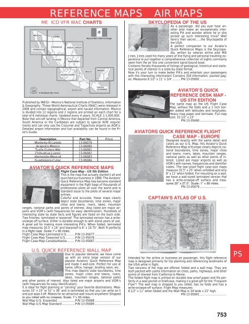
ME ICO VFR WAC CHARTS<br />
Published by INEGI - Mexico's National Institute of Statistics, Information<br />
& Geography. These World Aeronautical Charts (WAC) were released in<br />
2008 and contain topographical, airport and navaid information. Mexico<br />
is divided into 12 regions and 2 regions are printed on each chart for a<br />
total of 6 individual charts. Updated every 4 years. SCALE 1:1,000,000.<br />
Note that aircraft landing in Mexico that departed from Central America,<br />
South America or the Caribbean are subject to special AOE requirements<br />
and can only use the Cozumel and Tapachula airports as AOE's.<br />
Detailed airport information and fuel availablilty can be found in the Pilot's<br />
Guide.<br />
Description Part No. Price<br />
Monterey-N.Laredo 13-06079 .<br />
Acapulco-Mexico 13-06080 .<br />
Tuxtla Gutierz-Mer 13-06081 .<br />
Chihuahua-Juarez 13-06082 .<br />
Hermosillo-Mexicali 13-06083 .<br />
Guadalajara-Culiac 13-06084 .<br />
AVIATOR’S QUICK REFERENCE MAPS<br />
Flight Case Map - US 5th Edition<br />
This is the map that actually started it all and<br />
launched our business in 1988. The Aviators’<br />
Quick Reference Map has become standard<br />
equipment in the flight bags of thousands of<br />
professional pilots all over the world and is<br />
standard issue to the pilots of several major<br />
airlines.<br />
Colorful and accurate, these maps clearly<br />
depict state boundaries, time zones, major<br />
cities and towns, rivers, lakes, mountain<br />
ranges, national parks and points of interest. Also listed are major airports<br />
and VOR’s (with frequencies for easy identification). Hundreds of<br />
interesting state by state facts and figures are listed on the back side.<br />
Two finishes: laminated or tearproof. The laminated version has a writeon/wipe-off<br />
surface. Either is durable enough to with stand years of use.<br />
A great aid for making more interesting PA’s. When folded, laminated<br />
map measures 10.5” x 16” and tearproof is 8” x 10.75”. Both fit perfectly<br />
in a flight case. Scale 1”= 90 miles.<br />
Flight Case Map Laminated U.S..........P/N 13-05677..............................<br />
Flight Case Map Tearproof U.S...........P/N 13-05678..............................<br />
Flight Case Map Canada/Alaska.........P/N 13-05687..............................<br />
U.S. QUICK REFERENCE WALL MAP<br />
Due to popular demand, we have come<br />
up with an extra large version of our<br />
popular Aviators’ Quick Reference Map<br />
and made it wall-size. Perfect for use at<br />
home, office, hangar, briefing room, etc.<br />
This map depicts state boundaries, time<br />
zones, major cities and towns, rivers,<br />
lakes, mountain ranges, national parks<br />
and other points of interest. Also listed are major airports and VOR’s<br />
(with frequencies for easy identification).<br />
It is ideal for flight planning or “pinning” your favorite destinations. Measures<br />
33” x 23” or 52” x 36” and is laminated so that you can write on it<br />
and just wipe it off. Makes for an attractive wall mount anywhere! Shipped<br />
to you rolled with no creases. Scale: 1”= 55 miles.<br />
Wall Map U.S. Expanded ....................P/N 13-05688..............................<br />
Wall Map U.S Map Standard...............P/N 13-05689..............................<br />
SKYCLOPEDIA OF THE US<br />
As a passenger, did you ever hear another<br />
pilot make an exceptionally interesting<br />
PA and wonder where he or she<br />
picked up such interesting trivia? Well<br />
here’s their secret......the Skyclopedia of<br />
the USA.<br />
A perfect companion to our Aviator’s<br />
Quick Reference Maps is the Skyclopedia,<br />
written by veteran airline pilot Milt<br />
Jines. Jines used his many years of line flying and personal traveling experience<br />
to put together a comprehensive collection of sights commonly<br />
seen from the air into one convenient spiral-bound book.<br />
Contains literally thousands of listings of geological, historical and statistical<br />
points of interest in a state-by-state format.<br />
Now it’s your turn to make better PA’s and entertain your passengers<br />
with this interesting information! Contains 359 information- packed pages.<br />
Measures 8 1/2” x 11” x 3/4”..........PN 13-05692...............................<br />
AVIATOR’S QUICK<br />
REFERENCE DESK MAP -<br />
US 5TH EDITION<br />
The same map as the US Flight Case<br />
Map, without the folds and a 1 inch border<br />
added with lattitudes and longitudes.<br />
Heavy map paper and laminate. Full map<br />
size: 33 1/2” x 23”<br />
PN 13-05690...............................<br />
AVIATORS QUICK REFERENCE FLIGHT<br />
CASE MAP - EUROPE<br />
Designed exactly with the same detail and<br />
colors as our U.S. Map, this Aviator’s Quick<br />
Reference Map of Europe clearly depicts national<br />
boundaries, time zones, major cities<br />
and towns, rivers, lakes, mountain ranges,<br />
national parks as well as other points of interest.<br />
Listed are major airports as well as<br />
VOR’s with names, frequencies and identifier<br />
codes. The tear-proof flight case-size maps<br />
measure 32.5” x 25” when unfolded and only<br />
8” x 11” when folded. For mounting on a wall,<br />
we have a wall-sized laminated version that<br />
has a write-on/wipe-off surface and measures<br />
35” x 27.5”. Scale: 1” = 80 miles.<br />
PN 13-05679...............................<br />
CAPTAIN’S ATLAS OF U.S.<br />
Intended for the airline or business jet passenger, this flight reference<br />
map is designed primarily for trip planning and referencing landmarks of<br />
the USA while in flight.<br />
Two versions of the map are offered: folded and a wall map. They are<br />
both packed with useful information on cities, parks, highways, and other<br />
points of interest from California to Maine.<br />
The folded flight map is printed on durable tear-proof paper and fits perfectly<br />
in a seat pocket or briefcase, making it a great gift for the “Frequent<br />
Flyer”! The wall map is shipped to you rolled, has no folds and has a<br />
write-on/wipe-off surface. Flight Map measures<br />
8 1/2” x 11” when folded and the Wall Map is 34”wide x 23” high.<br />
PN 13-05691...............................<br />
753<br />
CM<br />
WP<br />
ME<br />
HA<br />
AP<br />
LG<br />
EP<br />
CS<br />
IN<br />
EL<br />
AV<br />
TO<br />
PS<br />
BV