
Create successful ePaper yourself
Turn your PDF publications into a flip-book with our unique Google optimized e-Paper software.
CM<br />
WP<br />
ME<br />
HA<br />
AP<br />
LG<br />
EP<br />
CS<br />
IN<br />
EL<br />
AV<br />
TO<br />
PS<br />
BV<br />
758<br />
INSTRUMENT NAVIGATION CHARTS<br />
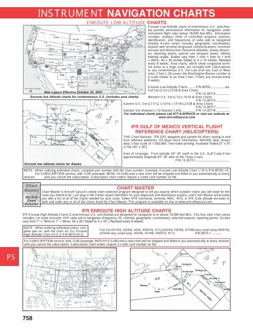
Enroute Low Altitude charts (Conterminous U.S. and Alaska)<br />
provide aeronautical information for navigation under<br />
instrument flight rules below 18,000 feet MSL. Information<br />
includes: airways; limits of controlled airspace; position,<br />
identification, and frequencies of radio aids to navigation<br />
(Alaska 4-color series includes geographic coordinates);<br />
airports with terminal air/ground communications; minimum<br />
enroute and obstruction clearance altitudes; airway distances;<br />
reporting points; special use airspace areas; military<br />
train ing routes. Scales vary from 1 inch = 5nm to 1 inch<br />
= 20nm. 50 x 20 inches folded to 5 x 10 inches. Revised<br />
every 8 weeks. Area charts, which show congested terminal<br />
areas at a large scale, are included with subscriptions<br />
to any conterminous U.S. Set Low (Full set, East or West<br />
sets). Chart L-28 covers the Washington-Boston corridor at<br />
a scale similar to an Area Chart. Charts are revised every<br />
8 weeks.<br />
Enroute Low Altitude Charts......... P/N 8070L.............. ./ea.<br />
Full Set (L1/2-L27/28 & Area Chart)<br />
New Layout Effective October 25, 2007.<br />
P/N 13-30714 .............. .<br />
Enroute low altitude charts for conterminous U.S. (includes area charts) Western U.S. Set (L1/2-L15/16 & Area Chart)<br />
P/N 13-30716 .............. .<br />
Eastern U.S. Set (L11/12, L13/14, L17/18-L27/28 & Area Chart)<br />
P/N 13-30717 .............. .<br />
Alaskan Set (Alaskan L1/2-Alaskan L3/4)................ P/N 13-30718 .............. .<br />
For individual charts please call 877-4-SPRUCE or visit our website at:<br />
www.aircraftspruce.com<br />
Enroute low altitude charts for Alaska<br />
IFR GULF OF MEXICO VERTICAL FLIGHT<br />
REFERENCE CHART (HELICOPTERS)<br />
THIS Chart features: IFR GPS waypoint grid system for direct routing to and<br />
from offshore platforms; Oil lease block information; NAVAID data, Airport<br />
data; Chart scale of 1:500,000; Two-sided printing; Available folded (5” x 9”)<br />
or flat (45” x 36”).<br />
Area of coverage: From latitude 26° 20’ north to the U.S. Gulf Coast.From<br />
approximately longitude 87° 30’ west to the Texas Coast.<br />
P/N 13-30721...................................... .<br />
NOTE: When ordering individual charts, complete part number with the chart number. Example: Enroute Low Altitude Chart L-10 is P/N 8070L-10.<br />
For SUBSCRIPTION service, add -SUB (example: 8070L-10-SUB) and a new chart will be shipped and billed to you automatically at every<br />
revision until you cancel the subscription. Subscription chart orders require a credit card number on file.<br />
CHART MASTER<br />
Chart Master is Aircraft Spruce’s online chart selection program designed to tell you exactly which aviation charts you will need for the<br />
route you intend to fly. Just plug in the 3 letter airport identifiers for your departure and destination airports, and Chart Master will provide<br />
you with a list of all of the charts needed for your route. Select VFR (sectional, terminal, WAC, AFD, or IFR (Low altitude enroute) or<br />
both and order any or all of the charts listed by Chart Master. This program is available on line at www.aircraftspruce.com.<br />
IFR ENROUTE HIGH ALTITUDE CHARTS<br />
IFR Enroute High Altitude Charts (Conterminous U.S. and Alaska) are designed for navigation at or above 18,000 feel MSL. This four color chart series<br />
includes: Jet route structure; VHF radio aid to navigation (frequency, ID, channel, geographic coordinates); selected airports; reporting points. (Scales<br />
vary from 1“ = 78nm to 1“ = 30nm. 55 x 20“ folded to 5 x 10“.) Revised every 8 weeks.<br />
NOTE: When ordering individual charts, complete<br />
part no. with the chart no. Ex: Enroute<br />
High Altitude Chart H1/2 is P/N 8075-H1/2.<br />
ENROUTE LOW ALTITUDE CHARTS<br />
Full Set (H1/H2, H3/H4, H5/6, H9/H10, H11),(H3/H4, H5/H6, H7/H8-very small area,H9/H10),<br />
(H3/H4-very small area, H5/H6, H7/H8, H9/H10, H11) P/N 8075-1 ...........<br />
For SUBSCRIPTION service: Add -SUB (example: 8075-H1/2-SUB) and a new chart will be shipped and billed to you automatically at every revision<br />
until you cancel the subscription. Subscription chart orders require a credit card number on file.