Water Resource Publication Duck Pond Drainage Basin OPP-WRP ...
Water Resource Publication Duck Pond Drainage Basin OPP-WRP ...
Water Resource Publication Duck Pond Drainage Basin OPP-WRP ...

You also want an ePaper? Increase the reach of your titles
YUMPU automatically turns print PDFs into web optimized ePapers that Google loves.
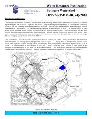
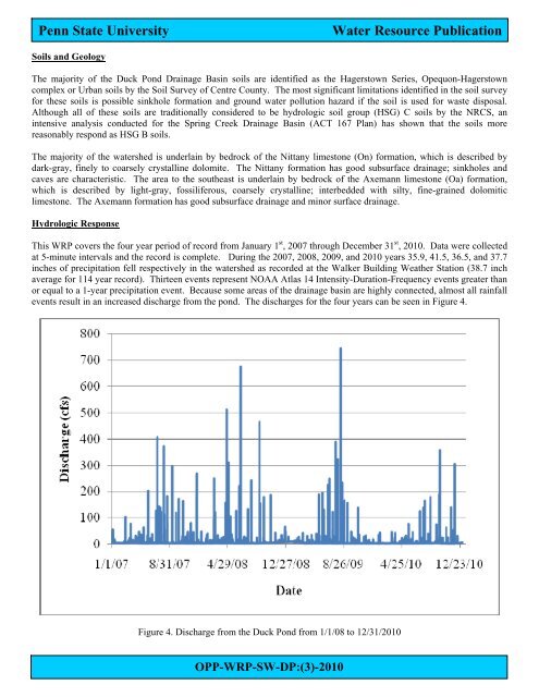
Penn State University<strong>Water</strong> <strong>Resource</strong> <strong>Publication</strong>Soils and GeologyThe majority of the <strong>Duck</strong> <strong>Pond</strong> <strong>Drainage</strong> <strong>Basin</strong> soils are identified as the Hagerstown Series, Opequon-Hagerstowncomplex or Urban soils by the Soil Survey of Centre County. The most significant limitations identified in the soil surveyfor these soils is possible sinkhole formation and ground water pollution hazard if the soil is used for waste disposal.Although all of these soils are traditionally considered to be hydrologic soil group (HSG) C soils by the NRCS, anintensive analysis conducted for the Spring Creek <strong>Drainage</strong> <strong>Basin</strong> (ACT 167 Plan) has shown that the soils morereasonably respond as HSG B soils.The majority of the watershed is underlain by bedrock of the Nittany limestone (On) formation, which is described bydark-gray, finely to coarsely crystalline dolomite. The Nittany formation has good subsurface drainage; sinkholes andcaves are characteristic. The area to the southeast is underlain by bedrock of the Axemann limestone (Oa) formation,which is described by light-gray, fossiliferous, coarsely crystalline; interbedded with silty, fine-grained dolomiticlimestone. The Axemann formation has good subsurface drainage and minor surface drainage.Hydrologic ResponseThis <strong>WRP</strong> covers the four year period of record from January 1 st , 2007 through December 31 st , 2010. Data were collectedat 5-minute intervals and the record is complete. During the 2007, 2008, 2009, and 2010 years 35.9, 41.5, 36.5, and 37.7inches of precipitation fell respectively in the watershed as recorded at the Walker Building Weather Station (38.7 inchaverage for 114 year record). Thirteen events represent NOAA Atlas 14 Intensity-Duration-Frequency events greater thanor equal to a 1-year precipitation event. Because some areas of the drainage basin are highly connected, almost all rainfallevents result in an increased discharge from the pond. The discharges for the four years can be seen in Figure 4.Figure 4. Discharge from the <strong>Duck</strong> <strong>Pond</strong> from 1/1/08 to 12/31/2010<strong>OPP</strong>-<strong>WRP</strong>-SW-DP:(3)-2010