

Geologic Mapping in Utah - Utah Geological Survey - Utah.gov
Geologic Mapping in Utah - Utah Geological Survey - Utah.gov
Geologic Mapping in Utah - Utah Geological Survey - Utah.gov

Create successful ePaper yourself
Turn your PDF publications into a flip-book with our unique Google optimized e-Paper software.
northwest over northern Canada—it has accelerated, deserted<br />
Canada, and is trekk<strong>in</strong>g across the Arctic Ocean toward Siberia.<br />
By 2018 it is expected to pass with<strong>in</strong> 250 miles of the geographic<br />
North Pole.<br />
A wander<strong>in</strong>g magnetic pole corresponds to a chang<strong>in</strong>g magnetic<br />
decl<strong>in</strong>ation for any particular location. The change of the magnetic<br />
decl<strong>in</strong>ation was first recognized nearly four centuries ago when<br />
discrepancies were noticed <strong>in</strong> compass read<strong>in</strong>gs over time at the<br />
same location. For Salt Lake City, decl<strong>in</strong>ation is currently decreas<strong>in</strong>g<br />
at a rate of about 7 m<strong>in</strong>utes of a degree per year. Besides updat<strong>in</strong>g<br />
decl<strong>in</strong>ation maps, magnetic field changes br<strong>in</strong>g about such<br />
actions as the occasional renumber<strong>in</strong>g and repa<strong>in</strong>t<strong>in</strong>g of airport<br />
runways, which are characteristically named based on magnetic<br />
head<strong>in</strong>g.<br />
Know<strong>in</strong>g the current magnetic decl<strong>in</strong>ation of your position allows<br />
you to determ<strong>in</strong>e compass bear<strong>in</strong>gs from a map that match what<br />
the actual bear<strong>in</strong>gs are <strong>in</strong> the real world. This is critical for crosscountry<br />
navigation from po<strong>in</strong>t A to po<strong>in</strong>t B. Decl<strong>in</strong>ation is <strong>in</strong>cluded<br />
<strong>in</strong> the explanatory <strong>in</strong>formation of U.S. <strong>Geologic</strong>al <strong>Survey</strong> (USGS)<br />
topographic quadrangle maps and maps <strong>in</strong>tended for navigational<br />
or wilderness use. On USGS maps, the decl<strong>in</strong>ation diagram shows<br />
geographic north as a vertical l<strong>in</strong>e with a five-po<strong>in</strong>ted star (H) at<br />
the top. The direction of magnetic north is <strong>in</strong>dicated by a l<strong>in</strong>e at an<br />
angle to the right (here <strong>in</strong> <strong>Utah</strong>) with an arrowhead and is marked<br />
“MN.” The diagram <strong>in</strong>cludes the size of the angle between geographic<br />
north and magnetic north <strong>in</strong> degrees, or mils, or typically<br />
both. Unrelated to decl<strong>in</strong>ation, USGS maps also <strong>in</strong>clude a third<br />
l<strong>in</strong>e (yes, a third north!) on the diagram marked “GN” or grid north,<br />
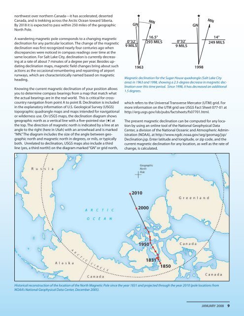
GN<br />
0°32'<br />
9 MILS<br />
1963<br />
MN<br />
16.5°<br />
293 MILS<br />
0°32'<br />
9 MILS<br />
GN<br />
1998<br />
MN<br />
14°<br />
249 MILS<br />
Magnetic decl<strong>in</strong>ation for the Sugar House quadrangle (Salt Lake City<br />
area) <strong>in</strong> 1963 and 1998, show<strong>in</strong>g a 2.5-degree decrease <strong>in</strong> magnetic decl<strong>in</strong>ation<br />
over this time period. S<strong>in</strong>ce 1998, it has decreased an additional<br />
1.5 degrees.<br />
which refers to the Universal Transverse Mercator (UTM) grid. For<br />
more <strong>in</strong>formation on the UTM grid see USGS Fact Sheet 077-01 at<br />
http://erg.usgs.<strong>gov</strong>/isb/pubs/factsheets/fs07701.html.<br />
The present magnetic decl<strong>in</strong>ation can be computed for any location<br />
by us<strong>in</strong>g an onl<strong>in</strong>e tool of the National Geophysical Data<br />
Center, a division of the National Oceanic and Atmospheric Adm<strong>in</strong>istration<br />
(NOAA), at http://www.ngdc.noaa.<strong>gov</strong>/seg/geomag/jsp/<br />
Decl<strong>in</strong>ation.jsp. Enter latitude and longitude, or zip code, and the<br />
current magnetic decl<strong>in</strong>ation for any location, as well as the rate of<br />
change, is calculated.<br />
Historical reconstruction of the location of the North Magnetic Pole s<strong>in</strong>ce the year 1831 and projected through the year 2010 (pole locations from<br />
NOAA’s National Geophysical Data Center, December 2005).<br />
JANUARY 2008 9


