

Geologic Mapping in Utah - Utah Geological Survey - Utah.gov
Geologic Mapping in Utah - Utah Geological Survey - Utah.gov
Geologic Mapping in Utah - Utah Geological Survey - Utah.gov

You also want an ePaper? Increase the reach of your titles
YUMPU automatically turns print PDFs into web optimized ePapers that Google loves.
From Field <strong>Mapp<strong>in</strong>g</strong> To Published Map<br />
by Kent D. Brown<br />
Most of us are familiar with photographs<br />
of early explorers of the American West,<br />
fight<strong>in</strong>g for their lives try<strong>in</strong>g to maneuver<br />
overloaded wooden boats down the rag<strong>in</strong>g<br />
Colorado River. Some of these explorers<br />
were geologists determ<strong>in</strong>ed to map the<br />
rugged expanse of unknown territory. Not<br />
only did they map the geology, but they<br />
also spent long periods of time mak<strong>in</strong>g<br />
relatively crude topographic maps on<br />
which the geologic maps were constructed.<br />
Today, geologic mapp<strong>in</strong>g <strong>in</strong> <strong>Utah</strong> cont<strong>in</strong>-<br />
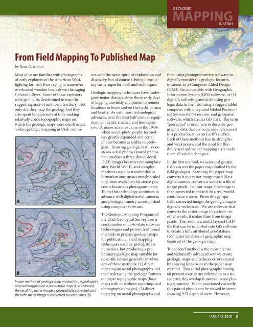
A<br />
B<br />
In one method of geologic map production, a geologist’s<br />
orig<strong>in</strong>al mapp<strong>in</strong>g on a paper base map (A) is scanned,<br />
the result<strong>in</strong>g raster image is geospatially corrected, and<br />
then the raster image is converted to vector l<strong>in</strong>es (B).<br />
ues with the same spirit of exploration and<br />
discovery, but of course is be<strong>in</strong>g done us<strong>in</strong>g<br />
vastly superior tools and techniques.<br />
<strong>Geologic</strong> mapp<strong>in</strong>g techniques have undergone<br />
major changes s<strong>in</strong>ce those early days<br />
of lugg<strong>in</strong>g unwieldy equipment to remote<br />
locations <strong>in</strong> boats and on the backs of men<br />
and beasts. As with most technological<br />
advances, over the next half century equipment<br />
got better, smaller, and less expensive.<br />
A major advance came <strong>in</strong> the 1940s<br />
when aerial-photography technology<br />
greatly expanded and aerial<br />
photos became available to geologists.<br />
Draw<strong>in</strong>g geologic features on<br />
stereo aerial photos (paired photos<br />
that produce a three-dimensional<br />
[3-D] image) became commonplace<br />
after World War II, and complex<br />
mach<strong>in</strong>es used to transfer this <strong>in</strong>formation<br />
onto an accurately scaled<br />
map were available; this stereo process<br />
is known as photogrammetry.<br />
Today this technology cont<strong>in</strong>ues to<br />
advance with digital aerial cameras<br />
and photogrammetry accomplished<br />
us<strong>in</strong>g computer software.<br />
The <strong>Geologic</strong> <strong>Mapp<strong>in</strong>g</strong> Program of<br />
the <strong>Utah</strong> <strong>Geologic</strong>al <strong>Survey</strong> uses a<br />
comb<strong>in</strong>ation of up-to-date software<br />
technologies and proven traditional<br />
methods to prepare geologic maps<br />
for publication. Field mapp<strong>in</strong>g<br />
techniques used by geologists are<br />
numerous, but produc<strong>in</strong>g a prelim<strong>in</strong>ary<br />
geologic map suitable for<br />
open-file release generally <strong>in</strong>volves<br />
one of three methods: (1) direct<br />
mapp<strong>in</strong>g on aerial photographs and<br />
then redraw<strong>in</strong>g the geologic features<br />
on paper topographic maps (base<br />
maps with or without superimposed<br />
photographic images), (2) direct<br />
mapp<strong>in</strong>g on aerial photographs and<br />
GEOLOGIC<br />
MAPPING IN UTAH<br />
then us<strong>in</strong>g photogrammetry software to<br />
digitally transfer the geologic features,<br />
<strong>in</strong> stereo, to a Computer Aided Design<br />
(CAD) file compatible with Geographic<br />
Information System (GIS) software, or (3)<br />
digitally collect<strong>in</strong>g and attribut<strong>in</strong>g geologic<br />
data <strong>in</strong> the field us<strong>in</strong>g a rugged tablet<br />
computer with <strong>in</strong>tegrated Global Position<strong>in</strong>g<br />
System (GPS) receiver and geospatial<br />
software, which creates GIS data. The term<br />
“geospatial” is used here to describe geographic<br />
data that are accurately referenced<br />
to a precise location on Earth’s surface.<br />
Each of these methods has its strengths<br />
and weaknesses, and the need for flexibility<br />
and <strong>in</strong>dividual mapp<strong>in</strong>g style make<br />
them all valid techniques.<br />
In the first method, we scan and geospatially<br />
correct the paper map drafted by the<br />
field geologist. Scann<strong>in</strong>g the paper map<br />
converts it to a raster image much like a<br />
digital camera converts a scene to a file of<br />
image pixels. For our maps, this image is<br />
then corrected to make it fit a real-world<br />
coord<strong>in</strong>ate system. From this geospatially<br />
corrected image, the geologic map is<br />
digitally vectorized. We use software that<br />
converts the raster image to vectors—<strong>in</strong><br />
other words, it makes l<strong>in</strong>es from image<br />
pixels. The result is a multi-layered CAD<br />
file that can be imported <strong>in</strong>to GIS software<br />
to create a fully attributed geodatabase<br />
(computer database of geographic map<br />
features) of the geologic map.<br />
The second method is the most precise<br />
and technically advanced way we create<br />
geologic maps and reduces errors caused<br />
by copy<strong>in</strong>g l<strong>in</strong>es twice <strong>in</strong> the paper map<br />
method. Two aerial photographs hav<strong>in</strong>g<br />
60 percent overlap are referred to as a stereo<br />
pair; this overlap is needed to use photogrammetry.<br />
When positioned correctly<br />
this pair of photos can be viewed <strong>in</strong> stereo<br />
show<strong>in</strong>g 3-D depth of view. However,<br />
JANUARY 2008 3


