

Geologic Mapping in Utah - Utah Geological Survey - Utah.gov
Geologic Mapping in Utah - Utah Geological Survey - Utah.gov
Geologic Mapping in Utah - Utah Geological Survey - Utah.gov

Create successful ePaper yourself
Turn your PDF publications into a flip-book with our unique Google optimized e-Paper software.
The Dome/ Diapir/ Dome<br />
Mounta<strong>in</strong> Dilemma<br />
by Sandy Eldredge<br />
An average of 270 <strong>in</strong>quiries about dome mounta<strong>in</strong>s<br />
reach our Web site every month. <strong>Utah</strong> teachers who<br />
address landforms often identify mounta<strong>in</strong> types<br />
formed by different processes. Up until the 1990s,<br />
some curricula materials listed four types of mounta<strong>in</strong>s<br />
(although there are more): fold, fault, volcanic,<br />
and dome. Teachers often def<strong>in</strong>ed a dome mounta<strong>in</strong><br />
as form<strong>in</strong>g from ris<strong>in</strong>g magma that pushed the<br />
overly<strong>in</strong>g rock layers upward to form a dome shape,<br />
without the magma break<strong>in</strong>g through the surface.<br />
However, geologists have a broader dome-mounta<strong>in</strong><br />
def<strong>in</strong>ition that <strong>in</strong>cludes any region of flat-ly<strong>in</strong>g sedimentary<br />
rocks warped upward to form a roughly circular<br />
shape, as well as accumulations of lava that pile<br />
up over a volcanic vent. Add<strong>in</strong>g to the confusion is<br />
that many mounta<strong>in</strong>s that do not fit the formal def<strong>in</strong>ition<br />
above are called dome mounta<strong>in</strong>s just because<br />
of their rounded shapes. These mounta<strong>in</strong>s should be<br />
referred to as just “dome-shaped” mounta<strong>in</strong>s.<br />
To help unravel some of the ambiguities, let’s take<br />
a look at several dome features and how they are<br />
formed.<br />
What is a dome?<br />
A dome is a circular or elliptical uplifted geologic feature<br />
on which the rock layers slope gently downward<br />
<strong>in</strong> all directions from a central high po<strong>in</strong>t. Generally<br />
the term is used for any dome-shaped landform.<br />
What are some of the dome structures?<br />
Lava domes, salt domes, salt diapirs, dome mounta<strong>in</strong>s,<br />
and laccoliths are several of many dome<br />
features.<br />
Southeastern <strong>Utah</strong>’s laccoliths are the La Sal, Henry,<br />
Abajo, and Navajo Mounta<strong>in</strong>s that rise above the<br />
flat sedimentary rock expanses. The La Sals, Henrys,<br />
and Abajos have aggregations of peaks composed<br />
of the igneous rock now exposed after the overly<strong>in</strong>g<br />
sedimentary rock layers were eroded off. Navajo<br />
Mounta<strong>in</strong>, a solitary dome mounta<strong>in</strong>, is different <strong>in</strong><br />
that the sedimentary rocks still cover the probable<br />
underly<strong>in</strong>g igneous <strong>in</strong>trusion.<br />
Teacher’s Corner<br />
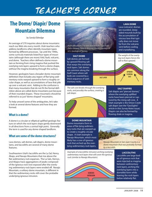
Elden Mounta<strong>in</strong> is a lava dome <strong>in</strong> the San Francisco<br />
volcanic field <strong>in</strong> Arizona. Photo courtesy of<br />
U.S. <strong>Geologic</strong>al <strong>Survey</strong>.<br />
SALT DOME<br />
Salt domes are formed<br />
by upward-flow<strong>in</strong>g salt<br />
that warps the overly<strong>in</strong>g<br />
rock layers. Salt domes<br />
are common along the<br />
Gulf Coast where salt<br />
beds are covered by a<br />
thick sequence of sedimentary<br />
rocks.<br />
IGNEOUS<br />
INTRUSION<br />
SALT LAYER<br />
The salt core breaks through the overly<strong>in</strong>g<br />
rocks, and possibly the surface, creat<strong>in</strong>g a<br />
salt diapir.<br />
DOME MOUNTAIN<br />
Dome mounta<strong>in</strong>s form <strong>in</strong><br />
areas of flat-ly<strong>in</strong>g sedimentary<br />
rocks that are warped up<br />
to create a roughly circular<br />
shape. A <strong>Utah</strong> example is<br />
Navajo Mounta<strong>in</strong>, which most<br />
likely has a core of igneous<br />
rock that arched up the overly<strong>in</strong>g<br />
sedimentary rock layers.<br />
Example of a laccolithic <strong>in</strong>trusion arch<strong>in</strong>g overly<strong>in</strong>g<br />
sedimentary rock layers that still cover the igneous<br />
rock (similar to Navajo Mounta<strong>in</strong>).<br />
LAVA DOME<br />
Lava (volcanic) domes<br />
are rounded, steepsided<br />
mounds built by<br />
the accumulation of<br />
viscous lava that typically<br />
does not move<br />
far from the volcanic<br />
vent before cool<strong>in</strong>g<br />
and crystalliz<strong>in</strong>g.<br />
The weight of the overly<strong>in</strong>g<br />
rock layers forces the<br />
salt to flow upward.<br />
UPWARD<br />
FLOWING<br />
SALT<br />
SALT DIAPIRS<br />
Salt diapirs are “pierced domes,”<br />
where the overly<strong>in</strong>g uplifted<br />
rocks have been pierced or ruptured<br />
by the ris<strong>in</strong>g salt core. A<br />
<strong>Utah</strong> example is the Onion Creek<br />
salt diapir (see the “GeoSights”<br />
article <strong>in</strong> this <strong>Survey</strong> Notes issue).<br />
Diapirs can also be formed by<br />
flow<strong>in</strong>g shale or magma.<br />
Navajo Mounta<strong>in</strong> <strong>in</strong> San Juan County is a<br />
dome mounta<strong>in</strong> that was probably formed<br />
by a laccolith.<br />
LACCOLITHS<br />
Laccoliths are large bodies<br />
of igneous rock that<br />
were <strong>in</strong>jected as magma<br />
between sedimentary<br />
rock layers, arch<strong>in</strong>g the<br />
overly<strong>in</strong>g layers <strong>in</strong>to a<br />
domelike form while<br />
leav<strong>in</strong>g the rock layers<br />
below relatively flat.<br />
JANUARY 2008 11


