M9a Rainfall and runoff introduction.pdf
M9a Rainfall and runoff introduction.pdf
M9a Rainfall and runoff introduction.pdf
- No tags were found...

You also want an ePaper? Increase the reach of your titles
YUMPU automatically turns print PDFs into web optimized ePapers that Google loves.
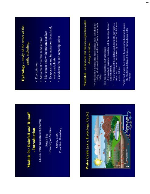
Module 9a: <strong>Rainfall</strong> <strong>and</strong> Runoff- IntroductionCE 378 Water Resources EngineeringRobert PittUniversity of AlabamaShirley ClarkPenn State HarrisburgWater Cycle (a.k.a. Hydrologic Cycle)Hydrology – study of the water of theearth, including:• Precipitation• Movement over the l<strong>and</strong> surface• Movement below the ground surface• Evaporation <strong>and</strong> transpiration from l<strong>and</strong>,water <strong>and</strong> plants• Condensation <strong>and</strong> reprecipitationWatershed – all l<strong>and</strong> area that drains to a specified outletduring a rainstorm“A watershed is the l<strong>and</strong> area between ridge lines, including thevalley, which contributes rainfall <strong>runoff</strong> to the stream in thevalley.”Two basic principles about watersheds:• A watershed’s perimeter boundary will be the ridge lines ofadjacent terrain.• Water will run off these ridges, <strong>and</strong> down into the valley, at90 o to each contour line crossed by the water. This is knownas the fall line.“Water will always flow across the contour <strong>and</strong> downhill, acrossthe shortest <strong>and</strong> steepest distance, perpendicular to thecontour.”1
Watershed Delineation ExampleXWatershed Delineation ExampleXWatershed Delineation HintsThe determination of a watershed’s area begins with the analysisof a topographic map of the region. The most downstreampoint of interest (a potential dam site, a culvert location, theoutlet of a stream, where a stream reaches a river, etc.) islocated. The area contributing flow to that site is then identifiedby application of a few simple rules:• Water flows downhill• Water tends to flow perpendicularly across the contour lines• Ridges are indicated by contour “V”s pointing downhill• Drainages are indicated by contour “V”s pointing upstream.2
Information SourcesThe Delineation ProcessUSGS Topographic Maps• The fundamental source of data for delineating <strong>and</strong> studyingwatersheds is the U.S. Geological Survey Quadrangle map. Each“Quad Sheet” map covers 7.5 minutes of longitude <strong>and</strong> latitude.• These maps give a wealth of information including topographiccontour lines, locations of cities, buildings, roads, road types,railroads, pipelines, water bodies, forested l<strong>and</strong>, stream networks,<strong>and</strong> USGS stream gauging stations <strong>and</strong> benchmarks.• Quad sheet maps typically have a scale of 1:24,000 (i.e. 1 inch onthe map = 24,000 inches in• Depending on the age of the map, elevation data may be in Englishor Metric units. Typically, here in the Midwest, the contourintervals of the elevation data are 5 feet or 1.5 meter. For watersheddelineation, quad sheet maps offer us the best starting point.The Delineation Process• There are two basic steps to follow in watershed delineation.• Step 1:– Choose the point of the watershed outlet. This is generally our point ofinterest for designing a structure or monitoring location.• Step 2:– Delineate the watershed boundary by drawing perpendicular lines acrossthe elevation contour lines for l<strong>and</strong> that drains to the point of interest.• Note - There are a few things to remember when you are workingwith topographic maps.– A watershed boundary always runs perpendicular to the contour lines.– “Arrows” that point upstream are valleys.– “Arrows” that point downstream are hills.Digital Elevation ModelsDigital Elevation Models (DEM’s) store topographic datain the form of grid cells. Typically, these grid cells have aresolution of 30 meters <strong>and</strong> elevation intervals of 1 foot or1 meter.Using a DEM within a Geographical Information System(GIS), we can perform digital terrain analysis (DTA) suchas calculating slopes, flow lengths, <strong>and</strong> delineatewatershed boundaries <strong>and</strong> stream networks.However, there are certain drawbacks to DTA becausesome algorithms are not very smart, especially indelineating watershed boundaries.3
Important Watershed CharacteristicsOther Important Watershed Factors• L<strong>and</strong> Cover <strong>and</strong> Use• Surface Roughness• Soil Characteristics– Texture– Soil Structure– Soil Moisture– Hydrologic Soil Groups6
Topographic Map Photo-updated 1978 Aerial Photograph Taken 1999 www.terraserver.com<strong>Rainfall</strong>-Runoff Processes• Runoff = <strong>Rainfall</strong> – Initial abstractions – Infiltration• Initial abstractions are mostly detention storage(“puddles”), interception by vegetation, flashevaporation, etc. Runoff cannot occur until theseinitial losses are satisified.• Infiltration mostly occurs on pervious surfaces <strong>and</strong> isrepresented by one of several historical equaitons(Horton’s equation, or the Green Ampt equation arethe most common).http://www.naturegrid.org.uk/rivers/graphics/pudd-soil.gif7
Initial AbstractionsMicro-scale detention storage “puddles” on rough pavementMonthly Pan Evaporation at Boulder City, NV110 inches (9.2 ft) annual totalOctNovDecJanFebMarTotalperiod:7.64.23.23.44.17.029.5NOAA Climatological DataAprilMayJuneJulyAugSeptTotalperiod:9.813.615.716.214.210.980.4St<strong>and</strong>ard Class A Evaporation Pan withcup anemometerU.S. Weather BureauMean AnnualEvaporation fromShallow Lakes(inches)U.S. Dept. of Agriculture, SoilConservation Service8
Soil modifications can result in greatly enhancedinfiltration in marginal soils.www.seafriends.org.nz/enviro/ soil/geosoil.htmPonding during very intense rain in areahaving s<strong>and</strong>y soils. Watershed Soil Characteristics• County Soil Surveys contain much informationconcerning local soils• Generally prepared with 2 samples per acre, thereforeonly general• They do not consider the disruption to the soils thatoccurs with l<strong>and</strong> development (compaction, cut <strong>and</strong>fill, etc.)• Basic information is very important, but informationmust be modified based on these modifications9
Soil SurveysSoil surveys have been generated by the U.S.Department of Agriculture (National ResourceConservation Service – formerly the SoilConservation Service) <strong>and</strong> are typically availablethrough the county extension office.Information typically available in a soil survey:• Soil type by general area• Descriptions of the various soil types• Tables of information regarding the various soil types• Soil classification (Hydrologic Soil Group A, B, C,<strong>and</strong> D)GeneralSoil MapforAlabamaAlabama Online Soil SurveyManuscriptshttp://soils.usda.gov/survey/online_surveys/alabama/Baldwin County (1964)Manuscript (13.0 MB)Index to Detailed Soil Map Sheets (630 KB)General Soil Map (927 KB)Barbour County (2004)Text, tables, <strong>and</strong> maps (2.2 MB)Butler County (1997)Text <strong>and</strong> Tables (4.0 MB)General Soil Map (453 KB)Index to Detailed Soil Map Sheets.Choctaw County (2003)Manuscript (2.64 MB)Index to Detailed Soil Map Sheets (1.26 MB)General Soil Map (493 KB)Soil Survey Background Information:• Soil scientists observed the steepness, length,<strong>and</strong> shape of the slopes; the general pattern ofdrainage; the kinds of crops <strong>and</strong> native plants;<strong>and</strong> the kinds of bedrock. They dug manyholes to study the soil profile, which is thesequence of natural layers, or horizons, in asoil. The profile extends from the surfacedown into the material in which the soilformed. The material is devoid of roots <strong>and</strong>other living organisms <strong>and</strong> has not beenchanged by other biological activity.10
Arendtsville Soil ProfileSoil Survey Information on Building SiteDevelopment• Shows the degree <strong>and</strong> kind of soil limitations that affectshallow excavations, dwellings with <strong>and</strong> without basements,small commercial buildings, local roads <strong>and</strong> streets, <strong>and</strong> lawns<strong>and</strong> l<strong>and</strong>scaping.• The limitations are considered slight if soil properties <strong>and</strong> sitefeatures are generally favorable for the indicated use <strong>and</strong>limitations are minor <strong>and</strong> easily overcome; moderate if soilproperties or site features are not favorable for the indicateduse <strong>and</strong> special planning, design, or maintenance is needed toovercome or minimize the limitations; <strong>and</strong> severe if soilproperties or site features are so unfavorable or so difficult toovercome that special design, significant increases inconstruction costs, <strong>and</strong> possibly increased maintenance arerequired. Special feasibility studies may be required where thesoil limitations are severe.11
Water Features of the Soil: Hydrologic Soil Group• Hydrologic soil groups are based on estimates of <strong>runoff</strong> potential. Soils areassigned to one of four groups according to the rate of water infiltration whenthe soils are not protected by vegetation, are thoroughly wet, <strong>and</strong> receiveprecipitation from long-duration storms.• The four hydrologic soil groups are:– Group A. Soils having a high infiltration rate (low <strong>runoff</strong> potential) whenthoroughly wet. These consist mainly of deep, well drained to excessively draineds<strong>and</strong>s or gravelly s<strong>and</strong>s. These soils have a high rate of water transmission.– Group B. Soils having a moderate infiltration rate when thoroughly wet. Theseconsist chiefly of moderately deep or deep, moderately well drained or well drainedsoils that have moderately fine texture to moderately coarse texture. These soilshave a moderate rate of water transmission.– Group C. Soils having a slow infiltration rate when thoroughly wet. These consistchiefly of soils having a layer that impedes the downward movement of water orsoils of moderately fine texture or fine texture. These soils have a slow rate ofwater transmission.– Group D. Soils having a very slow infiltration rate (high <strong>runoff</strong> potential) whenthoroughly wet. These consist chiefly of clays that have a high shrink-swellpotential, soils that have a high water table, soils that have a claypan or clay layer ator near the surface, <strong>and</strong> soils that are shallow over nearly impervious material.These soils have a very slow rate of water transmission.13
Precipitation patterns for a regiondetermined by:• Meteorological conditions• Geographic conditions• Topographic conditions• Geologic conditionsPrecipitationPrecipitation includes• Rain• Snow• Hail• SleetPrecipitation is the primary source of water in streams,lakes, springs <strong>and</strong> wells.Precipitation is expressed as an average intensity over aspecified time period (usually as rain depth/unit time)<strong>Rainfall</strong> characteristics• Duration: length of time over which aprecipitation event occurs• Volume: amount of precipitation occurringover the storm duration (usually reported as adepth that is assumed to have occurred evenlyacross watershed)• Frequency: the “regularity/oftenness” ofevents with the same duration <strong>and</strong> volume14
Intensity: volume/duration (units of depth/time)Frequency can be reported in two ways:• Exceedence probability: the probability that anevent having a specified depth <strong>and</strong> duration will beexceeded in one time period (usually 1 year)• Return period: average length of time betweenevents having the same depth <strong>and</strong> durationRelationship between exceedence period (p) <strong>and</strong> returnperiod (T):p = 1/TPrecipitation Data – <strong>Rainfall</strong> Maps15
<strong>Rainfall</strong> Patterns <strong>and</strong> IDF CurvesDeveloping Design Storms for DrainageDesign• Constant Intensity Design Storms• Unit Hyetograph Storms (such as the24-hour SCS Storm DesignDistribution)<strong>Rainfall</strong> Frequency• <strong>Rainfall</strong> frequency is commonly expressed as theaverage return period of the event.• The value should be expressed as the probability ofthat event occurring in any one year.• As an example, a 100-yr storm, has a 1% chance ofoccurring in any one year, while a 5-yr storm has a20% chance of occurring in any one year.• Multiple rare events may occur in any one year, butthat is not very likely.Design Storm Selection Guidelines(Source: Model Drainage Manual, American Association of State Highway <strong>and</strong> Transportation Officials,Washington, D.C. 1991 as given in Garber <strong>and</strong> Hoel. Traffic <strong>and</strong> Highway Engineering, Second Edition.PWS Publishing Company, 1997).Roadway ClassificationExceedence ProbabilityReturn PeriodRural principal arterial system2%50 yearRural minor arterial system2 – 4%25 – 50 yearRural collector system, major4%25 yearRural collector system, minor10%10 yearRural local road system10 – 20%5 – 10 yearUrban principal arterial system2 – 4%25 – 50 yearUrban minor arterial street system4%25 yearUrban collector street system10%10 yearUrban local street system10 – 20%5 – 10 yearNOTE: Federal law requires interstate highways to be provided with protection from the2% flood event, <strong>and</strong> facilities such as underpasses, depressed roadways, etc. where nooverflow relief is available should be designed for the 2% event.16
Time of Concentration (t c )• The duration must be equal to the time ofconcentration for the drainage area.• The time of concentration (t c ) is equal to the longestflow path (by time).• If the t c is 5 min for a storm having a return period of25 years, the associated peak intensity (which has aduration of 5 min) would be about 8.6 in/hr.• If the t c for this same return period was 40 min, thepeak rain intensity would be “only” 3.8 in/hr.Birmingham Intensity - Duration - Frequency (IDF) Curve<strong>Rainfall</strong> Frequency• <strong>Rainfall</strong> frequency is commonly expressed as theaverage return period of the event.• The value should be expressed as the probability ofthat event occurring in any one year.• As an example, a 100-yr storm, has a 1% chance ofoccurring in any one year, while a 5-yr storm has a20% chance of occurring in any one year.• Multiple rare events may occur in any one year, butthat is not very likely.17
SCS (NRCS) <strong>Rainfall</strong> DistributionsZones of Different <strong>Rainfall</strong> Distributions <strong>Rainfall</strong> Distributions in the Southeastern U.S.18
Probability of designstorm (design returnperiod) not beingexceeded during theproject life (designperiod).As an example, if aproject life was 5years, <strong>and</strong> a stormwas not to beexceeded with a 90%probability, a 50 yeardesign return periodstorm must be used.19