

GIS-based Environmental Sensitivity Index (ESI) mapping for oil ...
GIS-based Environmental Sensitivity Index (ESI) mapping for oil ...
GIS-based Environmental Sensitivity Index (ESI) mapping for oil ...
- No tags were found...

You also want an ePaper? Increase the reach of your titles
YUMPU automatically turns print PDFs into web optimized ePapers that Google loves.
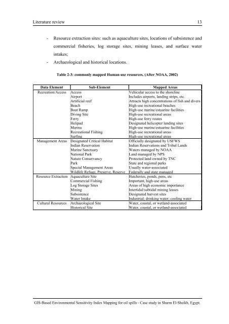
Literature review 13- Resource extraction sites: such as aquaculture sites, locations of subsistence andcommercial fisheries, log storage sites, mining leases, and surface waterintakes;- Archaeological and historical locations.Table 2-3: commonly mapped Human-use resources. (After NOAA, 2002)Data Element Sub-Element Mapped AreasRecreation/Access Access Vehicular access to the shorelineAirportIncludes airports, landing strips, etc.Artificial reefAttracts high concentrations of fish and diversBeachHigh-use recreational beachesBoat RampHigh-use marine/estuarine facilitiesDiving SiteHigh-use recreational areasFerryHigh-use ferry routesHelipadDesignated helicopter landing sitesMarinaHigh-use marine/estuarine facilitiesRecreational FishingHigh-use recreational areasSurfingHigh-use recreational areasManagement Areas Designated Critical Habitat Officially designated by USFWSIndian ReservationIndian Reservations and Tribal LandsMarine SanctuaryWaters managed by NOAANational ParkLand managed by NPSNature ConservancyProtected land owned by TNCParkState and regional parksSpecial Management Areas Usually water-associatedWildlife Refuge, Preserve, Reserve Federally and state managedResource Extraction Aquaculture SiteHatcheries, ponds, pens, etcCommercial FishingImportant, high-use areasLog Storage SitesAreas of high economic importanceMiningIntertidal/subtidal mining leasesSubsistenceDesignated harvest sitesWater IntakeIndustrial; drinking water; cooling waterCultural Resources Archaeological Site Water, coastal, or wetland-associatedHistorical SiteWater, coastal, or wetland-associated<strong>GIS</strong>-Based <strong>Environmental</strong> <strong>Sensitivity</strong> <strong>Index</strong> Mapping <strong>for</strong> <strong>oil</strong> spills - Case study in Sharm El-Sheikh, Egypt.


